- Point Isabel Regional Shoreline
-
For other uses, see Point Isabel (disambiguation).
Point Isabel Regional Shoreline 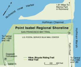
A map of the park and surrounding area, the land across the channel is known as North Point IsabelType Regional (East Bay Regional Parks) Location Richmond Area 23 acres (93,000 m2)s (9.3 hectares) Created 1975 Visitors 500,000 dogs Status Open all year Point Isabel Regional Shoreline in Richmond, California, operated by East Bay Regional Park District, is an award-winning park offering activities for humans as well as dogs. It also features a concession offering food for humans and grooming for pets. It has easy access for pedestrians, public transit, and private vehicles. A community organization, Point Isabel Dog Owners and Friends (PIDO), is dedicated to the maintenance and improvement of the park.
Contents
History
The 23-acre (93,000 m2) [1][2] park was acquired by the East Bay Regional Parks District in 1975 from the United States Postal Service which operated a large bulk mail facility there. The USPS offered to lease the land free of charge to the EBRPD until 2025 as a form of mitigation for the construction of their facility adjacent to the then-future shoreline park. The lease came with the condition of free public access.[3]
The park is currently undergoing about US $500,000 worth of capital improvements, including new irrigation systems and turf, fox tail removal, trail repavement, picnic sites and café seating. This is being funded by a portion of US $225 million collected by Measure AA (1998).[1]
The park, which receives over 500,000 canine visitors per year, was named the number one dog park by People for the Ethical Treatment of Animals (PETA) in 2006.[1]
It is named for the natural promontory of Point Isabel, which was itself named for landowner Victór Castro's daughter Isabel.[4]
The remains of Laci Peterson and her unborn child washed up, at two separate sites, on the shores of the park in 2003.
Overview
 A bird at the point.
The park is located along the eastern shore of the San Francisco Bay in the East Bay region of the Bay Area[1] and is administered by the East Bay Regional Park District. The park consists of the northwestern shoreline of the promontory of Point Isabel from Hoffman Marsh along Hoffman Channel to Richmond Inner Harbor.[5] The northern shore of the park against Hoffman Channel was formerly a sandy beach and has been modified from its original state by leveling and in-filling of the surrounding mudflats, tidal flats and other wetlands.[4] The rest of the area consists of a water treatment facility, radio towers, a US Postal Service facility, a Costco store, and office buildings. The parkland has an elevation of 16–25 feet (5–8 meters).
The Hoffman Channel is the outlet of Fluvius Innominatus creek from its mouth at the edge of its delta, Hoffman Marsh[6] The shoreline is lined with broken concrete blocks and other riprap.[5]
The park is open between 5 am and 10 pm PST; admission and parking are free, as stipulated by the lease agreement.[1][7] The park is fully wheelchair accessible.[1]
Eastshore State Park (ESP), a park incorporating wetlands along the shore of San Francisco Bay has already incorporated the Albany Mudflats to the south and hopes to incorporate Hoffman Marsh.[8] North Point Isabel Park, situated just north of the Point Isabel Shoreline, is already part of ESP.
 The park on a November day with Marin County in the background.
Point Isabel features two businesses aimed at visitors: Mudpuppy's Tub & Scrub, which is a dog grooming retail store and outlet, and the Sit & Stay Café, which offers drinks and sandwiches.[9]
The park also offers striking panoramic views of both Marin County mountains, San Francisco and the Golden Gate Bridge.[2] There are 3.2 miles (5.1 km) of flat trails which are generally wheelchair accessible and stroller friendly.[8] Part of trails in the park belongs to the San Francisco Bay Trail.[5]
The park supplies biodegradable bags called "mutt mitts" which are worn around the hand to retrieve animal waste. These bags cost the EBRPD about US$34,000 annually.[9][10]
Park rules
Leashes are optional for non-aggressive dogs in Point Isabel with certain restrictions. Dogowners must have a leash on hand, clean up their pet's waste and fill up holes dug by their pet. Dogs who become aggressive must be leashed immediately. Dogs are allowed to swim in Hoffman Channel, but not in Hoffman Marsh. Dogowners also must prevent their pets from disturbing feeding birds at low tide.[10]
Transportation
The park is served by AC Transit's 25 bus line, which links to the El Cerrito Plaza BART station and Downtown Berkeley.[11] The park is also accessible by car via I-80 and I-580 from the Central Avenue exit. There is ample parking in two parking lots and additional street parking as well.[8]
The park connects to the San Francisco Bay Trail leading into the Marina Bay neighborhood[12] northwestwards into Richmond and southwards through Berkeley to Emeryville.[13]
PIDO
Point Isabel Dog Owners and Friends (PIDO) is a community organization that works to raise funds for park maintenance and preservation.[9][10] Point Isabel has also been noted in the media for its safety, lack of vandalism, and cleanliness.[9]
The organization assists in funding mutt mitts and promotes their use to visitors. Self-policing by parkgoers and PIDO members has been credited with making the park dog waste-free.[9]
PIDO sponsors "good citizenship" testing and accreditation for dogs as well as fundraising events, volunteer park cleaning, and a dog festival entitled "Barktoberfest".[14]
See also
- Point Isabel, the promontory on which the park is situated.
Notes
- ^ a b c d e f Point Isabel profile, East Bay Regional Parks District, retrieved July 25, 2007
- ^ a b Perfect Picnics, Go dog, go: Bayside playground is a fetching spot for pups and their pals, San Francisco Chronicle, by Karola Saekel, May 23, 2007, retrieved July 30, 2007
- ^ Point Isabel text side, Point Isbael Regional Shoreline Brochure, East Bay Regional Parks District, retrieved August 26, 2007
- ^ a b El Cerrito Historical Society, Point Isabel, retrieved July 31, 2007
- ^ a b c Point Isabel map side, East Bay Regional Parks District, retrieved August 26, 2007
- ^ Baxter Creek & Fluvius Innominatus Topo, 1995, Museum of California, retrieved September 17, 2007
- ^ News and Announcements, PIDO, July 17, 2007, retrieved July 31, 2007
- ^ a b c Point Isabel Regional Shoreline, Bayhiker, retrieved August 1, 2007
- ^ a b c d e Point Isabel Shoreline the largest off-leash dog park in the nation, by Glen Martin, San Francisco Chronicle, August 16, 2004, retrieved July 25, 2007
- ^ a b c About Point Isabel, PIDO, retrieved August 1, 2007
- ^ 25, complete schedule, AC Transit, March 28, 2010, retrieved July 24, 2010
- ^ Leeways SF, Point Isabel Regional Park, retrieved July 31, 2007
- ^ fd_pointisabelshorelinemap.jpg/Point Isabel Regional Shoreline map, San Francisco Chronicle, retrieved July 31, 2007
- ^ Calendar, PIDO, retrieved August 1, 2007
External links
- Point Isabel Regional Shoreline at the East Bay Regional Parks District website
- Mudpuppy's Tub & Scrub and Sit & Stay Café
Coordinates: 37°53′56″N 122°19′27″W / 37.8990°N 122.3243°W
- Trails map
- Point Isabel at bay Hiker, report, images
- Pbase, photos
- Pido.org Point Isabel Dog Owners and Friends
- Point Isabel commentary at Yelp.com
East Bay Regional Parks Parks Anthony Chabot · Briones · Castle Rock · Contra Loma · Coyote Hills · Crockett Hills · Del Valle · Diablo Foothills · Dry Creek Pioneer · Garin · Lake Chabot · Middle Harbor Shoreline · Pleasanton Ridge · Redwood · Ridgelands · Shadow Cliffs · Sobrante Ridge · Temescal · Tilden · Wildcat CanyonShorelines Antioch/Oakley · Brooks Island · Carquinez Strait · Hayward · Martin Luther King Jr. · Martinez · Miller/Knox · Point Isabel · Point Pinole ·Preserves/Open Spaces Wilderness Areas Recreation Areas Trails Other Categories:- Richmond, California
- East Bay Regional Park District
- Parks in Richmond, California
- Dog parks in the United States


Wikimedia Foundation. 2010.