- Dent Blanche
-
Not to be confused with Dents Blanches.
Dent Blanche 
The northern ridge of Dent BlancheElevation 4,357 m (14,295 ft) Prominence 900 m (2,953 ft) [1] Parent peak Matterhorn Location Location in Switzerland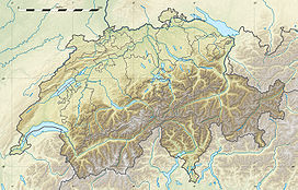
 Dent Blanche
Location Valais, Switzerland Range Pennine Alps Coordinates 46°02′03″N 7°36′43″E / 46.03417°N 7.61194°ECoordinates: 46°02′03″N 7°36′43″E / 46.03417°N 7.61194°E Climbing First ascent 1862 Easiest route rock/snow/ice climb The Dent Blanche is a mountain in the Pennine Alps, lying in the canton of Valais in Switzerland. With its 4,356 metres (14,291 ft) high summit, it is one of the highest peaks in the Alps.[2]
Contents
Naming
The original name was probably Dent d'Hérens, the actual name of the nearby Dent d'Hérens which does not overlook the Val d'Hérens. The nearby north face of the Dent d'Hérens is glaciated while the Dent Blanche holds much less snow, it was even called Dent Noire (Black Tooth) on the Woerl Atlas of 1842. In fact on older maps, in the area where lie both summits, only the name Weisszahnhorn (from German: White Tooth Peak) was indicated, the French name (Dent Blanche) appearing in 1820 only. Because cartographers usually made their observations far away from the mountainous remote areas and also because the Dent d'Hérens is sometime hidden behind the Dent Blanche thus less visible, the latter received the name. The inabitants of the lower Val d'Hérens called the actual Dent d'Hérens, Dent Blanche, but the ones of the upper Val d'Hérens called the mountain, Dent de Rong or Dent d'Erins, contributing to the general confusion. The actual names are official since the completion of the Dufour map in 1862.[3]
Geography
 Dent Blanche rising above the Val d'Hérens (right)
The summit of Dent Blanche is an important geographic place as it is the converging point of three ridges. The three valleys separated by them are the Val d'Hérens, Val d'Anniviers and Mattertal. The respective villages of Evolène, Zinal and Zermatt lie approximatively at the same distance of the mountain.
The Dent Blanche has four steep faces rising over four glaciers: The north-east face (also called north face) rises above the Grand Cornier Glacier (part of the Zinal Glacier), the south-east face rises above the Schönbiel Glacier (part of the Zmutt Glacier), the south-west face rises above the Manzettes Glacier (part of the Ferpècle Glacier) and, finally, the north-west face of Dent Blanche rises above the homonym glacier.
The four ridges encompass almost exactly the four cardinal directions. The west ridge is named Arête de Ferpècle and the east ridge is named Arête des Quatre Ânes. The Col de la Dent Blanche (3,531 m) lies at the foot of the northern ridge, the Bivouac de la Dent Blanche is located there. The Dent Blanche Hut lies at the foot of the southern ridge which is used as the normal route.
The region around Dent Blanche consists of many 4000 metres peaks. The Ober Gabelhorn (west), Dent d'Hérens and Matterhorn (south) are the closest high summits.
Climbing history
 Panorama from the Grand Mountet Hut with the Dent Blanche north face on the far right, the summit on the left is the Ober Gabelhorn
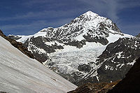 The south-east face and the southern ridge (normal route) on the left
The first ascent was made via the south ridge (Wandfluegrat), which is the less difficult route to the summit and the actual normal route. On 12 July 1862, T. S. Kennedy, after an attempt on the east face of the unconquered Matterhorn, almost reached the summit with the guides Peter Taugwalder and his son. But after a minor accident, Peter Taugwalder refused to go any higher. Kennedy would finally reach the summit only a few days later, on July 18, 1862 with W. Wigram, J. Croz and J. Konig, despite adverse weather conditions.[4]
A route on the west ridge was opened on 11 August 1882 by John Stafford Anderson and G. P. Baker, with guides Alois Pollinger and Ulrich Almer. They started from the Mountet Hut and arrived at the summit after a difficult 12 hours climbing on a dangerous ridge overlooking the north face. As Almer said on the summit: "We are four asses", the ridge was then named Arête des Quatre Ânes or Viereselsgrat (Ridge of the Four Asses).[4]
The north ridge was explored in 1899. On 28 August O. G. Jones, F. W. Hill with guides E. Furrer, C. Zurbriggen and J. Vuignier headed to the summit but they fell and only Hill survived. He reached alone the summit and a storm forced him to make a bivouac. He could report the news of the fatal accident in Zermatt only two days later.[4]
The first ascent of the north face is attributed to K. Schneider and F. Singer on 26 and 27 August 1932. They climbed from the left part at the base of the face to the summit. Only on 12 July 1966, M. and Y. Vaucher made a direct ascent on the north face.[4]
The first winter ascent by the north ridge was completed by P. Crettaz and J. Gaudin on March 2, 1963.
A solo winter ascent on the north face was made for the first time in 1968 by C. Bournissen.[4]
References
External links
- Dent Blanche on PeakWare - photos
- Dent Blanche on Summitpost
- Dent Blanche on Evolene's official webcam
Matter Valley Settlements Mountains Barrhorn · Brunegghorn · Bishorn · Weisshorn · Zinalrothorn · Ober Gabelhorn · Dent Blanche · Tête Blanche · Dent d'Hérens · Matterhorn · Klein Matterhorn · Breithorn · Pollux · Castor · Lyskamm · Monte Rosa · Gornergrat · Strahlhorn · Rimpfischhorn · Allalinhorn · Alphubel · Täschhorn · Dom · Lenzspitze · Nadelhorn · BalfrinGlaciers Categories:- Alpine Four-thousanders
- Mountains of Valais
- Mountains of the Alps
- Pennine Alps


Wikimedia Foundation. 2010.