- U.S. Route 6
-
U.S. Route 6
Grand Army of the Republic Highway 
Route information Length: 3,205 mi[1] (5,158 km) Existed: 1926[1] – present Major junctions West end:  US 395 in Bishop, CA
 I-15 near Provo, UT
 I-25 in Denver, CO
 I-35 near Des Moines, IA
 I-55 in Joliet, IL
 I-65 in Gary, IN
 I-75 in Bowling Green, OH
 I-90 in Cleveland, OH
 I-81 in Scranton, PA
 I-95 in Providence, RI
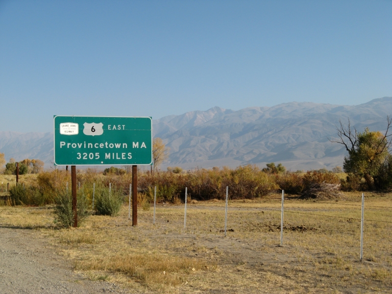
East end:  Route 6A in Provincetown, MA
Highway system United States Numbered Highways
List • Bannered • Divided • ReplacedU.S. Route 6 (US 6), also called the Grand Army of the Republic Highway, a name that honors an American Civil War veterans association, is a main route of the U.S. Highway system, running east-northeast from Bishop, California to Provincetown, Massachusetts. Until 1964, it continued south from Bishop to Long Beach, California, and was a transcontinental route. After U.S. Route 20, it is the second-longest U.S. highway in the United States and the longest continuous highway.
Contents
Route description
From 1936 until 1964, when most of its route through California was eliminated, US 6 was the longest highway in the country, but the truncation dropped its length below that of U.S. Route 20. When it was designated in 1926, it only ran east of Erie, Pennsylvania, and roughly fit into the overall grid (though the diagonal routing of U.S. Route 20 through Erie places it north of US 6). However, subsequent extensions, largely replacing the former U.S. Route 32 and U.S. Route 38 (which were in sequence), have taken it south of U.S. Route 30 near Chicago, Illinois, U.S. Route 40 near Denver, Colorado (past the end of US 38), U.S. Route 50 at Ely, Nevada, and even U.S. Route 70 near Los Angeles, California, due to its north–south alignment in that state.[2]
Since it was pieced together from other routes, US 6 does not serve a major transcontinental corridor, as other highways like U.S. Route 40 do. George R. Stewart, author of U.S. 40: Cross Section of the United States of America, initially considered US 6, but realized that "Route 6 runs uncertainly from nowhere to nowhere, scarcely to be followed from one end to the other, except by some devoted eccentric". In the famous "beat" novel On the Road by Jack Kerouac, protagonist Sal Paradise actually considers hitchhiking on US 6 to Nevada, but is told by a driver that "there's no traffic passes through 6" and that he'd be better off going via Pittsburgh (the Pennsylvania Turnpike).[2]
Lengths mi km CA 41 66 NV 305 491 UT 373 600 CO 467 752 NE 373 600 IA 320 515 IL 172 277 IN 149 240 OH 259 417 PA 394 634 NY 78 126 CT 116 187 RI 25 40 MA 118 190 Total 3205 5158  Heading east from Bishop, California.
California
Main article: U.S. Route 6 in CaliforniaThe modern US 6 in California is a short, two-lane, north–south surface highway from Bishop to the Nevada state line. Prior to a 1964 highway renumbering project, US 6 extended to Long Beach along what is now US 395, California 14, Interstate 5, Interstate 110/California 110, and California 1. Despite the renumbering having removed all freeway portions, it is still part of the California Freeway and Expressway System. US 6's former routing included a short segment of the famous Arroyo Seco Parkway.
Currently, US 6 begins at US 395 in Bishop and heads north between farms and ranches in the Chalfant Valley at the base of the 14,000' (4,200 m) western escarpment of the White Mountains. After about 30 miles (50 km) Benton is reached, which has a cafe and gas station. California 120 begins here, heading west past Mono Lake through Lee Vining, over Tioga Pass, and through Yosemite National Park to the San Joaquin Valley. US 6 continues north to the Nevada state line.
Nevada
Main article: U.S. Route 6 in NevadaFrom the California border, US 6 heads northeast through semi-desert Queen Valley with Boundary Peak (Nevada), Nevada's highest summit and Montgomery Peak in California on the right. These twin peaks are the northernmost high summits of the White Mountains, both over 13,000 ft (4,000 m). The highway then climbs into the Pinyon-Juniper zone and crosses Montgomery Pass 7,167 ft (2,185 m).
From the pass, US 6 descends into barren shadscale desert, passing Columbus Salt Marsh on the left, then merging with US 95 from Coaldale Junction to Tonopah. Nevada Test and Training Range begins about 15 mi (24 km) southeast of Tonopah.
Just east of Tonopah, US 6 continues east across a series of desert mountain ranges and valleys, including the Monitor Range. At Warm Springs, Nevada 375, also known as the "Extraterrestrial Highway," departs to the southeast and US 6 assumes a northeasterly alignment across the Reveille, Pancake, Grant and White Pine Ranges. Rainfall increases eastward, so valleys become less barren and peaks over 11,500 ft (3,500 m) add scenic interest.
Ely is the largest town on Route 6 in Nevada. US 50 joins Route 6 at Ely. East of Ely, Routes 6/50 cross the Schell Creek Range, known for verdant forests and meadows, and for a large deer and elk population. The highway descends to the Snake Valley, then crosses the Snake Range at Sacramento Pass, north of Nevada's second-highest mountain, Wheeler Peak, where a branch road accesses Great Basin National Park. Beyond the pass, US 6 passes just north of Baker, a Mormon farming community, and reaches the Utah state line.
Utah
Main article: U.S. Route 6 in Utah U.S. Route 6 in Emery County, Utah
US 6 enters and leaves Utah concurrent with US 50. However, the two routes are different through the state. US 50 is the newer and shorter route. US 6 is the former route of US 50. US 6 forms an arch-shaped route with Spanish Fork at the apex.
Colorado
Main article: U.S. Route 6 in ColoradoUS 6 is concurrent with Interstate 70 for a significant portion of its length from the Utah state line to Denver. Within the city limits, US 6 follows Denver's 6th Avenue (known as "6th Avenue Freeway"). The highway then travels north briefly, and follows Interstate 76 for most of its length east of Denver. It is unsigned while it is overlapped. The highest altitude along US 6 is 11,990 feet (3,650 m) at Loveland Pass, where it crosses the Continental Divide. It continues down Clear Creek Valley until it reaches I-70, where it is briefly overlapped until I-70 leaves Clear Creek Valley. US 6 continues down Clear Creek and into Denver, where it turns into a freeway with 6 lanes. East of Denver, it continues east while joined with I-76 until it reaches Sterling, where it diverges from the interstate. The last town in Colorado it passes is Holyoke.
 U.S. Route 6 in Colorado
Nebraska
Main article: U.S. Route 6 in NebraskaFrom the Colorado state line, US 6 starts going southeast. The first town it goes into is Imperial. US 6 conjoins with US 34 near Culbertson, passing through McCook. US 6 then moves to the northeast, through Hastings. At Hastings, US 34 diverges and moves north. US 6 parallels Interstate 80 north of Milford until it reaches Lincoln. At Lincoln, US 6 becomes Cornhusker Highway, and moves north of I-80, until Gretna. There US 6 moves due north and becomes West Dodge Road and Dodge Street in Omaha. It passes through downtown Omaha on parallel one-way streets and runs concurrent with Interstate 480 in Omaha on its last Nebraska segment. It crosses the Missouri River into Iowa on a girder bridge completed in 1966 that replaced the Ak-Sar-Ben Bridge, which was the first road bridge to connect the two cities.
Iowa
Main article: U.S. Route 6 in IowaUS 6 enters Iowa at Council Bluffs, across the Missouri River from Omaha, Nebraska. It heads due east until Lewis, where it turns sharply north-northeast to Atlantic. There, it runs concurrently with US 71 north until I-80. It overlaps with I-80 between US 71 and US 169 at De Soto. It runs north with US 169 to Adel, then turns east to go through Des Moines, where it is also known as Hickman Road joins Iowa Highway 28 at 63rd st and then heads north on Merle Hay Rd. Then turns East again on Douglas Ave, that turns in to Euclid and then Hubbell Ave. Route 6 is the reason that the north side of Des Moines' major east/west 4 lane street has three different names. At Altoona, US 6 rejoins I-80. It continues east with I-80 until Newton, where it splits northward from I-80 to run parallel. US 6 passes through Grinnell and Marengo before arriving in Iowa City, where it again crosses I-80. At West Liberty, it proceeds due east until Wilton, where it turns north to concurrency again with I-80. Arriving in Davenport, it becomes Kimberly Road until Interstate 74, with which it runs across the Mississippi River on the I-74 Bridge into Moline, Illinois.
Illinois
Main article: U.S. Route 6 in IllinoisIn Illinois, US 6 parallels Interstates 74 and 80, mostly along its original routing, overlapping with I-74 for its first 5 miles (8 km) and I-80 for the final 2 miles (5 km) of its routing in Illinois. US 6 directly serves the downtowns of many cities for its length, including Moline, Geneseo, Atkinson, Annawan, Ottawa, Channahon, and Joliet — unlike US 20, which, in Illinois, mainly consists of freeway sections that bypass the cities US 6 serves. Like nearby U.S. highways 30 and 52, US 6 avoids the Chicago city limits.
Indiana
Main article: U.S. Route 6 in IndianaUS 6 crosses the state line and shares the same Borman Expressway with Interstates 80 and 94 through Hammond and Gary, until Indiana 51 (Exit 15); it then runs south for about 2 miles (3.2 km) and turns east until it meets US 421 in Westville, then runs south for a mile, then east until it meets US 31 and US 35, and it shares the same road with US 33 for about 5 miles (8.0 km) until Ligonier, where US 33 breaks south toward Fort Wayne. From there it is mostly two lanes through Indiana until it meets the Ohio state line just east of Butler. Before the Borman Expressway was completed, US 6 was on Ridge Road, portions of which are now signed Business US 6.
Ohio
US 6 enters Ohio from Indiana in Williams County. It travels just south of Bryan before it passes through Napoleon, Bowling Green, and Fremont, before turning northeast towards Sandusky Bay and Lake Erie. After passing through Sandusky, the route follows the southern shore of Lake Erie, passing through Huron and Vermilion. After crossing the Charles Berry Bridge in Lorain, it passes through the western suburbs of Greater Cleveland as Lake Road in Sheffield Lake, Avon Lake, Bay Village, and Rocky River, and Clifton Boulevard in Lakewood and the West Blvd./Edgewater neighborhood of Cleveland proper. US 6 follows the Cleveland Memorial Shoreway into Downtown Cleveland, entering downtown by crossing the Detroit-Superior Bridge. US 6 follows Superior Avenue through Public Square and the East Side of Cleveland before turning east onto Euclid Avenue in East Cleveland and Chardon Road in the city of Euclid. US 6 continues eastward through Geauga County and finally into Ashtabula County before entering the state of Pennsylvania slightly north of Pymatuning Reservoir.
Ohio also has an alternate route of US 6 in the Cleveland area.
Pennsylvania
Main article: U.S. Route 6 in PennsylvaniaUS 6 runs for 394 miles (634 km) in Pennsylvania between its entrance point 20 miles (32 km) west of Meadville and its exit at Matamoras. From the Ohio border to US 322 in Conneaut Lake, the route runs in a southeasterly direction. US 6 then joins US 322 and heads east to Meadville, picking up US 19 west of the city. South of downtown, US 322 splits from the concurrency while US 6 and US 19 remain concurrent through Meadville. The two routes continue northward to Mill Village, where US 6 and US 19 split at a junction with US 6N.
For the remainder of its routing in Pennsylvania, US 6 runs roughly parallel to the New York-Pennsylvania border. Along the way, US 6 is concurrent with US 62 for a short distance near Warren. US 11 joins US 6 from the north in Factoryville. They run concurrently to Scranton, where US 11 continues south and US 6 east. At Milford, US 6 meets US 209. The two routes embark to the northeast, crossing the Delaware River from Matamoras to Port Jervis, New York.
New York
 US 6 climbing into the mountains of Harriman State Park, New YorkMain article: U.S. Route 6 in New York
The 79-mile (127 km) portion of US 6 in New York is located primarily in Orange County, with lengthy stretches in Putnam and Westchester counties, and a small segment in Rockland County. The route enters the state along with US 209 in Port Jervis. The two routes split just north of town, with US 209 taking a more northerly route to access Kingston. US 6, in contrast, runs primarily east–west through southern New York.
A section of US 6 runs concurrent with New York State Route 17 (the Quickway, or Southern Tier Expressway) between Goshen and Harriman. At Harriman, NY 17 becomes an at-grade road and heads south, while US 6 remains a limited-access highway as it heads east into Harriman State Park. Near the east side of the park, US 6 intersects the Palisades Interstate Parkway and runs concurrent with it to the Bear Mountain Bridge, where US 6 is joined by US 202 as it crosses the Hudson River.
On the other side of the river, US 6 and US 202 run along the Hudson to Peekskill, where the two routes split, allowing US 6 to continue to the northeast into Putnam County. In Brewster, US 6 meets US 202 once again. The routes become intertwined once more, running concurrent with one another into Connecticut.
 US 6 Bypass sign on the Roberts Expressway, now US 6
Connecticut
Main article: U.S. Route 6 in ConnecticutUS 6 runs for 116.3 miles (187.2 km) in Connecticut. It begins in the city of Danbury after crossing from New York, concurrent with US 202, and ends at the Rhode Island state line in the town of Killingly. In western Connecticut, US 6 either closely parallels or is concurrent with Interstate 84, serving as the local route in the suburbs of Danbury, Waterbury, Bristol, and Hartford. It crosses the Connecticut River (overlapped with I-84 and US 44) on the Bulkeley Bridge. In eastern Connecticut, US 6 is one of the principal routes connecting Hartford and Providence, R.I., passing through the small urban areas of Willimantic and Danielson. The unsigned portion of the Connecticut Turnpike then meets with US 6 shortly before crossing the Rhode Island state line.
Rhode Island
Main article: U.S. Route 6 in Rhode IslandUS 6 covers approximately 26.5 miles (42.6 km) in Rhode Island from Foster (western border with Killingly, CT) to East Providence (eastern border with Seekonk, MA). In and around Providence, US 6 overlaps with Route 10, as well as US 1A, US 44, and Interstates 95 and 195.
 Heading west from Provincetown, Mass.
Massachusetts
Main article: U.S. Route 6 in MassachusettsU.S. 6 runs approximately 117.5 miles (189.1 km) in Massachusetts. It parallels I-195 between Providence, R.I., and Wareham, and serves as the local business route. US 6 continues onto Cape Cod across the Sagamore Bridge as a freeway from Bourne to Orleans. North of Orleans, it becomes a surface road again to its terminus in Provincetown.
History
New England

The first interstate numbering along the path of US 6 was Route 3 (NE-3) of the New England road marking system, designated in 1922. This route connected Provincetown with the Connecticut-New York border via Providence, Hartford, and Danbury.[3][4] In late 1925, the Joint Board on Interstate Highways approved the preliminary plan for U.S. Highways. US 6 was restricted to New England and southeastern New York, with its vague description matching the existing Route 3 to Danbury, Connecticut, and heading west from there to U.S. Route 7 at Brewster, New York.[5] By the time the final plan was approved in late 1926, a second section had been added, from the New York-Pennsylvania border at Port Jervis, New York west to U.S. Route 120 in Kane, Pennsylvania.[6] This did not last long, for the April 1927 route log shows the eastern segment running only to the border of New York, short of Brewster, while the western segment was extended in both directions - east to Kingston, New York, and west to Erie, Pennsylvania (the latter replacing part of US 120). The western segment was also swapped with U.S. Route 106 between Carbondale and Tunkhannock, Pennsylvania, taking US 6 through Scranton.[7] The gap through New York was eliminated in 1928 with a new alignment across the state, crossing the Hudson River on the Bear Mountain Bridge; the old route between Kingston and Port Jervis became the first U.S. Route 6N.[2]
While US 6 replaced the general corridor of Route 3 in New England, some portions used different alignments. One of these was on Cape Cod, where Route 3 had used a southerly alignment that is now Route 28. Instead, US 6 followed the more direct route between Buzzards Bay and Orleans that had been the southern extremity of Route 6, and now known as Route 6A. Farther west, in Connecticut, US 6 ran via South Coventry, while Route 3 had served Andover; the old route became U.S. Route 6A.[citation needed] US 6 is now on the old Route 3, while the South Coventry route now carries Route 31. A different alignment was also chosen for US 6 between Plainville and Woodbury; Route 3 ran via Milldale and Waterbury, and became parts of Route 14 and Route 10 in the 1932 renumbering.[8] Here US 6 mostly remains on its original routing, with the main difference being between Hartford and Terryville, where US 6 followed the present Route 4, Route 10, and Route 72. The final difference was from Danbury west to the New York state line; here US 6 ran straight west, while Route 3 had left the Danbury area to the south, curving to the southwest through Ridgefield to the border. Part of this became U.S. Route 7, while the rest became Route 35 in 1932.[citation needed][3][4][7]
In New York, US 6 replaced all of Route 37 - known as the "Bridge Route" - over the Bear Mountain Bridge, overlapped part of Route 17, and was assigned to an unnumbered road from Middletown west to Port Jervis.[9] The original route, which soon became US 6N, replaced Route 50, and is now part of U.S. Route 209. The part of US 6 in Pennsylvania replaced Route 7, also known as the Roosevelt Highway, an auto trail.[4] The Roosevelt Highway Association extended the name east with US 6 to Cape Cod by 1930.[10]
Extensions
Two other routes that would become part of US 6 were included in the 1925 plan: U.S. Route 32 from Chicago, Illinois to Omaha, Nebraska, and U.S. Route 38 from Lincoln, Nebraska, to Greeley, Colorado.[5] As part of the fine-tuning during 1926, US 38 was extended east from Lincoln to Omaha, allowing U.S. Route 77, which had been assigned to this road, to extend north to Sioux City. These routes, which now connected end-to-end at Omaha, replaced a large portion of the Detroit-Lincoln-Denver Highway, which split at Princeton to bypass Chicago to the south via Joliet. They followed existing state highways: 2 and 14 in Colorado, 7 in Nebraska, 2 and 7 in Iowa, and 7 and 18 in Illinois.[4][6]
Most of US 32 and all of US 38 became a western extension of US 6 on June 8, 1931, and the Roosevelt Highway name followed.[11] To connect western Pennsylvania to central Indiana, relatively minor roads[4] (including the route for SR 6 in Indiana) were used, except west of Joliet, where it used a part of the old Detroit-Lincoln-Denver Highway. The short stub to Erie formed at the old west end became U.S. Route 6N, and US 32 remained in Illinois, running independently from Chicago to Princeton and overlapping US 6 to Davenport, Iowa.[2] US 32 has since been absorbed into U.S. Route 34.
The Roosevelt Highway Association continued to push for an extension,[12] and in December 1936 the American Association of State Highway Officials made US 6 (and thus the Roosevelt Highway) a transcontinental route from Cape Cod, Massachusetts to Long Beach, California.[13][14] It took a new route from Wiggins, Colorado, southwest to Denver (the old route to Greeley became an extended U.S. Route 34[citation needed]) and west over the Rocky Mountains to Leadville, overlapping U.S. Route 24 to Grand Junction and U.S. Route 50 to Spanish Fork, Utah. From Spanish Fork to Ely, Nevada, it followed a roadway that had yet to be improved in areas; the rest of the route, from Ely to Southern California, followed the old Midland Trail, running almost north–south in California. The unimproved segment from Ely east to Delta, Utah, about 160 miles (260 km) long, was, according to Business Week, "nothing but a wagon trail-rutted, filled with dust...one of the worst chunks of federal [sic] road in the country." Paving was completed in September 1952, with a two-day celebration in Delta marking the occasion.[2]
Major William L. Anderson, Jr. of the U.S. Army recommended that US 6 be designated the Grand Army of the Republic Highway, honoring the Union soldiers in the Civil War. The Sons of Union Veterans of the Civil War began pushing for the name in April 1934. Massachusetts, the first state to apply the name, passed a law to do so on February 2, 1937; it was not until at least 1948 that all states had agreed. The highway was formally dedicated at the Long Beach end on May 3, 1953,[2] though the Roosevelt Highway Association continued to exist at least through the 1960s.[15]
Modern history
As part of the 1964 renumbering in California, US 6 was truncated to its intersection with U.S. Route 395 at Bishop. The portion that did not overlap other routes, including US 395 and State Route 11, was redesignated State Route 14.[2][16]
Starting in the spring of 1983 U.S. 6 was a discontinuous route for almost one year, due to a massive landslide that destroyed the town of Thistle, Utah. The highway was rebuilt by blasting a path higher up the canyon wall. The landslide remains the most costly in the history of the United States.
See also
- Bannered routes of U.S. Route 6
- U.S. Route 106
- U.S. Route 206
- U.S. Route 138
- U.S. Route 6N (Pennsylvania)
- U.S. Route 6N (New York)
- Massachusetts Route 6A
References
- ^ a b US Highways From US 1 to US 830 Robert V. Droz
- ^ a b c d e f g Richard F. Weingroff, U.S. 6: The Grand Army of the Republic Highway
- ^ a b National Survey Company, The official National Survey maps and guide for Southern New England: Massachusetts, Connecticut, Rhode Island, 1926, accessed via the Broer Map Library
- ^ a b c d e Rand McNally Auto Road Atlas, 1926, accessed via the Broer Map Library
- ^ a b Report of Joint Board on Interstate Highways, October 30, 1925, Approved by the Secretary of Agriculture, November 18, 1925
- ^ a b United States System of Highways, November 11, 1926
- ^ a b United States Numbered Highways, American Highways (AASHO), April 1927
- ^ Connecticut State Highway Department, state map, 1932
- ^ Automobile Blue Book: Standard Touring Guide of America, 1926 and 1927 editions, Vol. 1 (New York and New England) (Automobile Blue Books, Inc., Chicago) – fold-out maps and turn by turn guides show the Port Jervis to Middletown route as unnumbered.
- ^ Wellsboro Gazette, Sixty Roosevelt Highway Association Members in Session, September 25, 1930
- ^ McKean County Democrat, Roosevelt Highway Route is Extended to Colorado, June 18, 1931
- ^ McKean County Democrat, Roosevelt Highway Association Renders Valuable Services, December 26, 1935
- ^ Times Independent, Roosevelt Highway at Last Gets Official Routing over No. 50, December 31, 1936, p. 5
- ^ Wellsboro Agitator, January 6, 1937: "The action taken at the recent San Francisco meeting of the American Association of State Highway Officials now gives it a single federal highway number from the Atlantic to the Pacific."
- ^ McKean County Democrat, 4-Lane Rt. 6 plan to be Discussed in Smethport, February 17, 1966
- ^ California Highway Department, 1963 State Highway Map and 1963 District VII State Highway Numbering Map
External links
- US-6 endpoint photos
- Federal Highway Administration: US 6
- U.S. Route 6 Tour Association
- Route 6: The Longest U.S. Transcontinental Highway
- US 6 in Connecticut (Scott Oglesby)
- Pennsylvania Route 6 Tourist Association
- Linesville, Pa., National U.S. Route 6 Museum Site
 Main U.S. Routes
1 2 3 4 5 6 7 8 9 10 11 12 13 14 15 16 17 18 19 20 21 22 23 24 25 26 27 28 29 30 31 32 33 34 35 36 37 38 40 41 42 43 44 45 46 48 49 50 51 52 53 54 55 56 57 58 59 60 61 62 63 64 65 66 67 68 69 70 71 72 73 74 75 76 77 78 79 80 81 82 83 84 85 87 89 90 91 92 93 94 95 96 97 98 99 101 163 400 412 425 Lists U.S. Routes • Bannered • Divided • Bypassed Browse numbered routes ←  SR 5
SR 5OH SR 7  →
→←  Route 2A
N.E. Route 4  →Categories:
- U.S. Route 6
- U.S. Highway System
- U.S. Highways in Indiana
- Transportation in Gary, Indiana
- U.S. Highways in Nebraska
- U.S. Highways in Ohio


Wikimedia Foundation. 2010.