- Hurricane Ioke
-
Hurricane/Typhoon Ioke Typhoon (JMA) Category 5 Hurricane/Super Typhoon (SSHS) 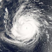
Hurricane Ioke on August 24, 2006. Formed August 20, 2006 Dissipated September 6, 2006 Highest winds 10-minute sustained:
195 km/h (120 mph)
1-minute sustained:
260 km/h (160 mph)Lowest pressure 915 mbar (hPa; 27.02 inHg)
(Lowest ever recorded in the Central Pacific)Fatalities None Damage $88 million (2006 USD) Areas affected Johnston Atoll, Wake Island, Minamitorishima, southern Alaska Part of the 2006 Pacific hurricane season and the 2006 Pacific typhoon season Hurricane Ioke (also referred to as Typhoon Ioke, international designation: 0612, JTWC designation: 01C, and sometimes called Super Typhoon Ioke) was the strongest hurricane ever recorded in the Central Pacific. The first storm to form in the Central Pacific in the 2006 Pacific hurricane season, Ioke was a record breaking, long-lived and extremely powerful storm that traversed the Pacific for 19 days, reaching the equivalent of Category 5 status on the Saffir-Simpson Hurricane Scale three times.
The cyclone developed from the Intertropical Convergence Zone on August 20 far to the south of Hawaii. Encountering warm waters, little wind shear, and well-defined outflow, Ioke intensified from a tropical depression to Category 4 status within 48 hours. Late on August 22 it rapidly weakened to Category 2 status before crossing over Johnston Atoll. Two days later favorable conditions again allowed for rapid strengthening, and Ioke attained Category 5 status on August 25 before crossing the International Date Line. As it continued westward its intensity fluctuated, and on August 31 it passed near Wake Island with winds of 155 mph (249 km/h). Ioke gradually weakened as it turned northwestward and northward, and by September 6 it had transitioned into an extratropical cyclone. The remnants of Ioke accelerated northeastward and ultimately crossed into Alaska.
Ioke did not affect any permanently populated areas in the Central Pacific or Western Pacific basins as a hurricane or a typhoon. A crew of 12 people rode out the hurricane in a hurricane-proof bunker on Johnston Atoll; the crew estimated winds reached over 100 mph (160 km/h), which damaged trees on the island but did not impact the island's bird population. The hurricane left moderate damage on Wake Island totaling $88 million (2006 USD), including blown off roofs and damaged buildings, though the infrastructure of the island was left intact; all military personnel were evacuated from the island. Later, the extratropical remnants of Ioke produced a severe storm surge along the Alaskan coastline, causing beach erosion.
Contents
Meteorological history
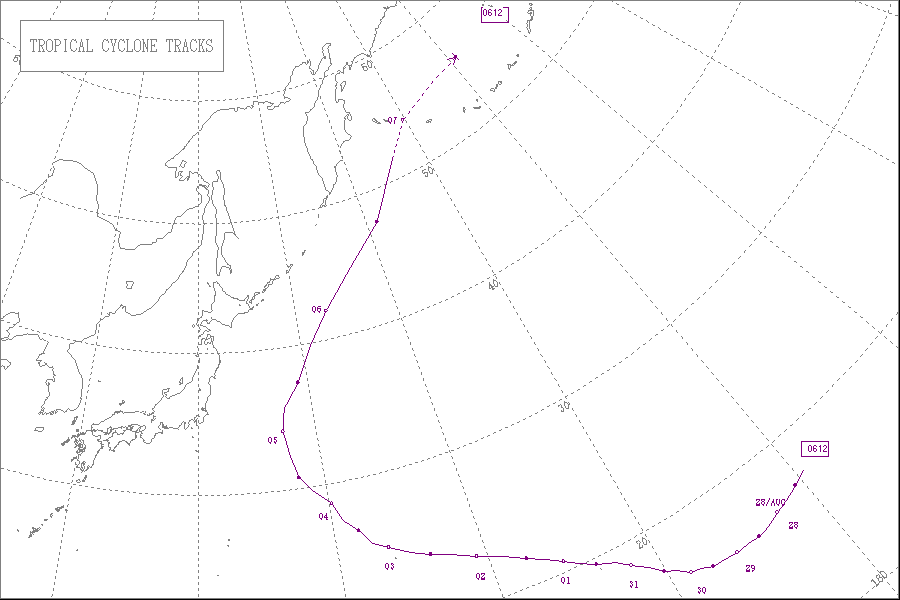
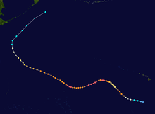 Storm path
The Intertropical Convergence Zone (ITCZ) spawned a tropical disturbance with a low-level circulation far to the southeast of Hawaiʻi in the middle of August 2006. Under the influence of a strong westward-moving subtropical ridge to its north, the disturbance tracked nearly due westward, with deep convection in the region increasing and decreasing on a daily basis. It slowly became better organized, and early on August 20 the disturbance developed into Tropical Depression One-C while located about 775 mi (1,247 km) south of Honolulu, Hawaii. At the time, there was no convection associated with the ITCZ within 10° Longitude.[1]
With wind shear practically non-existent and sea surface temperatures of around 82 °F (28 °C), conditions favored strengthening,[1] and operationally the cyclone was forecast to reach minimal hurricane status within four days before beginning to weaken.[2] The depression attained tropical storm status within six hours of developing.[1] The Central Pacific Hurricane Center designated the system with the name Ioke (
 /iːˈoʊkeɪ/), Hawaiian for the name Joyce.[3] Subsequently, Ioke quickly strengthened, and by late on August 20 the storm developed a central dense overcast and the beginnings of an eyewall;[4] early on August 21 the storm intensified into a hurricane, just 24 hours after first developing.[1]
 Typhoon Ioke gathering strength after crossing the International Date Line
Hurricane Ioke steadily deepened as it continued west-northwestward, with better definition of the eye and deepening of the eyewall convection.[5] Near the International Date Line a frontal trough turned the hurricane to the northwest, and after a period of rapid deepening Ioke attained winds of 135 mph (217 km/h) early on August 22 while located about 280 mi (450 km) southeast of Johnston Atoll. After maintaining Category 4 status on the Saffir-Simpson Hurricane Scale for about 18 hours,[1] southwesterly wind shear slightly disrupted the inner core of the hurricane,[6] and Ioke quickly weakened to winds of about 105 mph (169 km/h). Late on August 22, the hurricane passed about 30 mi (48 km) south of Johnston Atoll,[1] with the northeastern portion of the eyewall crossing the atoll early on August 23.[7] After turning westward later in the day, wind shear began to decrease, allowing a second period of rapid deepening. By August 24 the hurricane maintained a 23 mi (37 km) closed eyewall,[8] and on August 25 Ioke attained Category 5 status on the Saffir-Simpson Hurricane Scale while located about 970 mi (1,560 km) west-southwest of the Hawaiian Island of Kauaʻi.[1]
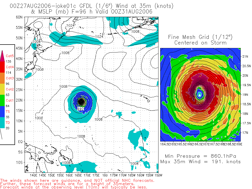
After maintaining Category 5 status for about 18 hours,[1] Hurricane Ioke weakened slightly due to an eyewall replacement cycle.[9] Completing the cycle on August 26,[10] the hurricane restrengthened to Category 5 status. The trough to its west tracked further away from the hurricane, allowing the subtropical ridge to build ahead of the hurricane which turned Ioke to the southwest.[1] The overall environment remained very favorable for sustainment of the powerful cyclone. Strong upper-level cyclones far to its northwest provided outflow channels and light wind shear, with warm water temperatures along its path.[10] With the conditions, the Geophysical Fluid Dynamics Laboratory hurricane model predicted Ioke to reach winds of 220 mph (350 km/h), with a predicted minimum pressure of 860 mbar (hPa).[11] Early on August 27, the pressure dropped to 915 mbar (hPa), and shortly thereafter Ioke crossed the International Date Line, becoming a 160 mph (260 km/h) typhoon.[1]
 Typhoon Ioke after brushing Wake Island
Unofficially referred as a super typhoon by the Joint Typhoon Warning Center (JTWC), Ioke remained at the equivalence of a Category 5 hurricane for about 12 hours after crossing the Date Line. It then began a slight weakening trend on August 28,[12] due to increased inflow from the ridge to its north.[13] On August 29, the cyclone turned to the west and west-northwest while tracking around the periphery of the subtropical ridge, and Ioke again reached the equivalence of Category 5 status.[12] The Japan Meteorological Agency (JMA) assessed Ioke as attaining peak 10 minute sustained winds of 120 mph (190 km/h) on August 30.[14] Later that day, the typhoon weakened to the equivalent of a Category 4 hurricane for the final time, and on August 31 Ioke passed very near Wake Island with winds of about 155 mph (249 km/h).[12]
 Typhoon Ioke after going over Wake Island
By September 1, increased wind shear and drier air caused the eye of Ioke to become cloud-filled and elongated,[15] and by September 2 Ioke was undergoing another eyewall replacement cycle.[16] On September 2, Ioke passed about 50 mi (80 km) north of Minami Torishima with winds of about 125 mph (201 km/h).[17] Gradual weakening continued, and the typhoon steadily shifted its track to the northwest around the subtropical ridge. A deepening trough turned Ioke to the north-northwest and north,[18] and the cyclone weakened to a tropical storm a few hundred miles east of Japan. After accelerating northeastward, the cyclone began losing tropical characteristics, and the JTWC declared Ioke as an extratropical cyclone on September 5.[12] The JMA maintained Ioke as a typhoon until a day later, and maintained Ioke as a tropical cyclone until it was declared extratropical midday on September 6. The extratropical remnants of Ioke were tracked by the JMA until September 7 when it was located near the Aleutian Islands of Alaska.[14] The storm deepened as it approached the Aleutians, and re-developed winds of hurricane-force. It entered the Bering Sea on September 8, and after turning eastward crossed the Aleutian Islands and entered the Gulf of Alaska. The extratropical remnants of Ioke dissipated near southeastern Alaska on September 12.[19]
Preparations and Impact
Johnston Atoll
Late on August 21, about 24 hours prior to its closest approach, the Central Pacific Hurricane Center issued a hurricane warning for uninhabited territory of Johnston Island,[20] due to the uncertainty of whether anyone was on the island.[21] A United States Air Force vessel and a 12 person crew were on the island, and after securing their ship the crew took shelter in a hurricane-proof concrete bunker.[1][22] There were no meteorological observations on the island, but the crew estimated tropical storm force winds lasted for about 27 hours with hurricane force winds lasting six to eight hours; peak wind gusts were estimated at 110 to 130 mph (180 to 210 km/h). The crew sustained no injuries, and their ship received only minor damage. Hurricane Ioke, with a portion of its eye crossing the atoll, left an estimated 15% of the palm trees on the island with their tops blown off, with some ironwood trees blown over; the island bird population was unaffected. The hurricane produced rough surf which washed away a portion of a sea wall and an adjacent road.[1]
Wake Island
 Damage on Wake Island after Ioke
Under the threat of the typhoon for several days, two C-17 Globemaster III airlifters evacuated between 188–200 military personnel from Wake Island to Hawaii, the first full-scale evacuation of the island since Typhoon Sarah in 1967.[23][24] A buoy just east of the island recorded a pressure of 921.5 mbar as Ioke crossed directly over it.[25] Before the typhoon passed just north of the island, an anemometer recorded hurricane force winds with a peak wind gust of 100 mph (160 km/h) before the instrument stopped reporting.[26] Sustained winds were estimated to have reached 155 mph (249 km/h), with gusts to 190 mph (310 km/h).[27] The minimum central pressure recorded on the island was 934 mbar at 0906 UTC on August 31.[26] The typhoon was expected to produce a storm surge of 18 ft (5.5 m) and wave heights of 40 ft (12 m) along Wake Island, where the highest point is 20 ft (6.1 m). Additionally, heavy rainfall from the typhoon left buildings flooded, with 2 ft (0.61 m) of standing water found several days after its passage.[28]
The powerful winds of Typhoon Ioke caused extensive damage to the island's power grid, leaving most power lines to buildings and backup generators damaged. The combination of the winds and storm surge flooding damaged 70% of the buildings in the territory, many of which with moderate roof damage. All low-lying areas were described as being covered with sea water or sand, and the territory was left without running water.[28] Communications were downed on the island, with satellite dishes and cables destroyed.[29] Damage to the infrastructure was extensive, though repairable and less than expected.[30] Damage on the island was estimated at $88 million (2006 USD, $90 million 2007 USD).[31]
Japan and Alaska
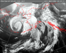 The extratropical remnants of Ioke over the Bering Sea, west of Alaska.
On September 1, the Japan Meteorological Agency ordered the temporary evacuation of its staff on Minami Torishima, under threat of the typhoon. The agency expected high waves and winds on the island.[32] Facilities on the island were damaged, although it was repaired and fully operational within three weeks after the storm.[33]
The extratropical remnant of Ioke produced a storm surge and high surf in excess of 30 ft (9.1 m) along the southwestern coastline of Alaska, which coincided with the astronomical high tide; the combination led to minor flooding along Bristol Bay and Yukon-Kuskokwim Delta.[34] Wind gusts peaked at 84 mph (135 km/h) in Unalaska.[35] The system produced moderate to heavy rainfall across the western portion of Alaska, including daily rainfall records of 1.15 inches (29 mm) at Bethel and 0.67 inches (17 mm) at Kotzebue. Rainfall continued into the southeastern portion of the state, contributing to above-normal rainfall totals near Juneau.[36]
Records and aftermath
Hurricane Ioke became one of five hurricanes to reach Category 5 status on the Saffir-Simpson Hurricane Scale in the Central North Pacific Ocean, and the only one originating in the basin. With an estimated minimum central pressure of 915 mbar (27.019 inHg), the cyclone attained the lowest estimated surface pressure for any hurricane within the basin,[1] surpassing the previous minimum set by Hurricane John in 1994.[37] Ioke maintained at least Category 4 status, or wind speeds greater than 131 mph (211 km/h), for 198 consecutive hours, which was the longest continuous time period at that intensity ever observed for any tropical cyclone anywhere on Earth.[1] Additionally, the cyclone remained at the equivalence of a super typhoon for 174 consecutive hours, which was also a record.[25] As a result of its extended duration and intensity, Hurricane/Typhoon Ioke accrued an Accumulated cyclone energy index of 82 104 kt2, which set a new worldwide record.[38]
The United States Coast Guard first performed an aerial assessment of damage on Wake Island on September 2, three days after the typhoon struck. The flight indicated an overall damage smaller than expected, and reported a lack of oil spill or hazardous material leak. The U.S. Coast Guard arrived by boat with a team on September 7, with a preliminary damage assessment completed four days later; the team repaired a generator to provide power.[28] A second crew analyzed the stability of the airfield, and after core tests workers cleared the runway to allow flights onto the territory.[39] On September 13, a group of engineers restored power on the island.[40] About a month after the cyclone, several buildings were operational.[30]
The Central Pacific Hurricane Center requested the retirement of the name, and in April 2007, the name Ioke was retired, and replaced with Iopa.[41]
See also
- 2006 Pacific hurricane season
- 2006 Pacific typhoon season
- List of Category 5 Pacific hurricanes
- List of tropical cyclones
- Timeline of the 2006 Pacific hurricane season
- Timeline of the 2006 Pacific typhoon season
- List of storms in the 2006 Pacific hurricane season
References
- ^ a b c d e f g h i j k l m n Central Pacific Hurricane Center (2007). "2006 Tropical Cyclones Central North Pacific". http://www.prh.noaa.gov/cphc/summaries/2006.php. Retrieved 2007-10-06.
- ^ Matsuda (2006). "Tropical Depression One-C Discussion One". Central Pacific Hurricane Center. http://www.prh.noaa.gov/cphc/tcpages/archive/2006/TCDCP2.CP012006.1.0608200252. Retrieved 2007-10-07.
- ^ Central Pacific Hurricane Center (August 3, 2005). "Tropical Storm Ioke Discussion Number 2". National Oceanic and Atmospheric Administration. http://www.prh.noaa.gov/cphc/tcpages/archive/2006/TCDCP2.CP012006.2.0608200853. Retrieved 2006-08-20.
- ^ Nash (2006). "Tropical Storm Ioke Discussion Four". Central Pacific Hurricane Season. http://www.prh.noaa.gov/cphc/tcpages/archive/2006/TCDCP2.CP012006.4.0608202049. Retrieved 2007-10-06.
- ^ Houston (2006). "Hurricane Ioke Discussion Seven". Central Pacific Hurricane Season. http://www.prh.noaa.gov/cphc/tcpages/archive/2006/TCDCP2.CP012006.7.0608211447. Retrieved 2007-10-06.
- ^ Browning (2006). "Hurricane Ioke Discussion Twelve". Central Pacific Hurricane Season. http://www.prh.noaa.gov/cphc/tcpages/archive/2006/TCDCP2.CP012006.12.0608222105. Retrieved 2007-10-06.
- ^ Donaldson (2006). "Hurricane Ioke Discussion Thirteen". Central Pacific Hurricane Season. http://www.prh.noaa.gov/cphc/tcpages/archive/2006/TCDCP2.CP012006.13.0608230245. Retrieved 2007-10-06.
- ^ Kodama (2006). "Hurricane Ioke Discussion Twenty". Central Pacific Hurricane Season. http://www.prh.noaa.gov/cphc/tcpages/archive/2006/TCDCP2.CP012006.20.0608242050. Retrieved 2007-10-06.
- ^ Burke (2006). "Hurricane Ioke Discussion Twenty-Five". Central Pacific Hurricane Season. http://www.prh.noaa.gov/cphc/tcpages/archive/2006/TCDCP2.CP012006.25.0608260248. Retrieved 2007-10-09.
- ^ a b Browning (2006). "Hurricane Ioke Discussion Twenty-Six". Central Pacific Hurricane Season. http://www.prh.noaa.gov/cphc/tcpages/archive/2006/TCDCP2.CP012006.26.0608260919. Retrieved 2007-10-09.
- ^ Geophysical Fluid Dynamics Laboratory (2006). "GFDL Hurricane Ioke Prediction: 2006-08-31 00z". NOAA. http://i35.photobucket.com/albums/d178/RattleMan/GFDL-860mb-191kt.png. Retrieved 2007-10-09.
- ^ a b c d Joint Typhoon Warning Center (2007). "Super Typhoon 01C". http://www.usno.navy.mil/NOOC/nmfc-ph/RSS/jtwc/atcr/2006atcr/NWP_IO/StormNWP_IO/cp01.html. Retrieved 2007-10-10.
- ^ Alpha Forecast Team (2006). "Typhoon Ioke Prognostic Reasoning NR 033". Joint Typhoon Warning Center. ftp://ftp.met.fsu.edu/pub/weather/tropical/GuamStuff/2006082803-WDPN.PGTW. Retrieved 2007-10-10.
- ^ a b Japan Meteorological Agency (2006). "2006 Western North Pacific Tropical Cyclones Best Track". http://www.jma.go.jp/jma/jma-eng/jma-center/rsmc-hp-pub-eg/Besttracks/bst2006.txt. Retrieved 2007-10-10.
- ^ Bravo Forecast Team (2006). "Typhoon Ioke Prognostic Reasoning NR 051". Joint Typhoon Warning Center. ftp://ftp.met.fsu.edu/pub/weather/tropical/GuamStuff/2006090115-WDPN.PGTW. Retrieved 2007-10-10.
- ^ Charlie Forecast Team (2006). "Typhoon Ioke Prognostic Reasoning NR 055". Joint Typhoon Warning Center. ftp://ftp.met.fsu.edu/pub/weather/tropical/GuamStuff/2006090215-WDPN.PGTW. Retrieved 2007-10-10.
- ^ Hendricks (2006). "Typhoon Ioke (01C) Advisory Number 56". Guam National Weather Service. http://weather.unisys.com/hurricane/archive/06090218. Retrieved 2007-10-16.
- ^ Delta Forecast Team (2006). "Typhoon Ioke Prognostic Reasoning NR 061". Joint Typhoon Warning Center. ftp://ftp.met.fsu.edu/pub/weather/tropical/GuamStuff/2006090403-WDPN.PGTW. Retrieved 2007-10-10.
- ^ George P. Bancroft (2007). "Marine Weather Review—North Pacific Area September through December 2006". NOAA National Center for Environmental Prediction. http://www.vos.noaa.gov/MWL/apr_07/northpacific.shtml. Retrieved 2007-10-16.
- ^ Kodama & Ballard (2006). "Hurricane Ioke Public Advisory Eight". Central Pacific Hurricane Center. http://www.prh.noaa.gov/cphc/tcpages/archive/2006/TCPCP2.CP012006.8.0608212103. Retrieved 2007-10-13.
- ^ Office of the Federal Coordinator for Meteorology (2007). "Actions and Recommendations for the 61st Interdepartmental Hurricane Conference" (PDF). p. 115. http://www.ofcm.gov/ihc07/web-61st-IHC-Booklet.pdf. Retrieved 2009-07-22.
- ^ Leone, Diana (2006-08-23). "Hawaiian-named storm hits Johnston Isle". Star Bulletin. http://starbulletin.com/2006/08/23/news/story01.html. Retrieved 2006-08-25.
- ^ Andrew Leonhard (2006-08-29). "Wake evacuated -- Airmen airlift 188 from Pacific Island". Air Force Print News. http://www.af.mil/news/story.asp?id=123026137. Retrieved 2007-10-14.
- ^ Associated press (2006). "Wake Island evacuated as Super Typhoon Ioke closes in". Anchorage Daily News. Archived from the original on May 28, 2008. http://web.archive.org/web/20080528023150/http://dwb.adn.com/news/alaska/ap_alaska/story/8132157p-8024611c.html. Retrieved 2008-10-31.
- ^ a b Gary Padgett (2006). "Tropical Cyclone Summary for August 2006". http://www.australiasevereweather.com/cyclones/2007/summ0608.htm. Retrieved 2007-10-11.
- ^ a b NOAA (2006). "Meteorological Observations for Wake Island on August 31, 2006". http://tidesandcurrents.noaa.gov/data_menu.shtml?bdate=20060830&bdate_Month=7&edate=20060831&edate_Month=7&unit=1&shift=&stn=1890000+Wake+Island%2C+U.+S.+TRUST+TERRITORY&type=Meteorological+Observations&format=View+Data. Retrieved 2007-10-15.
- ^ Chris Vadnais (2006-09-13). "Teams fly to Wake Island to assess damage". Air Force Print News. http://www.af.mil/news/story.asp?id=123026973. Retrieved 2007-10-15.
- ^ a b c Rob Tebben (2006). "Ioke on Wake Island" (PDF). Air Force Weather Observer. http://www.afweather.af.mil/shared/media/document/AFD-061108-011.pdf. Retrieved 2007-10-15.
- ^ Chris Vadnais (2006-09-17). "Airmen piece together Wake Island connectivity puzzle". Air Force Print News. http://www.af.mil/news/story.asp?id=123027270. Retrieved 2007-10-16.
- ^ a b Chris Vadnais (2006-09-29). "Airmen Add Up Damage at Wake" (PDF). Air Force Print News. http://www2.hickam.af.mil/shared/media/document/AFD-061101-039.pdf. Retrieved 2007-10-16.
- ^ Advisory Council for Historic Preservation (2007). "Spring 2007 Case Digest — Protecting Historic Properties" (PDF). p. 17. http://www.achp.gov/docs/case_spring_07small.pdf. Retrieved 2007-10-15.
- ^ Japan Meteorological Agency (2006). "Evacuation of Minami Torishima during Typhoon Ioke" (in Japanese). http://www.jma.go.jp/jma/press/0609/01a/marcus.html. Retrieved 2007-10-16.
- ^ Japan Meteorological Agency (2006). "About Weather Observation Reopening of the South Torishima Meteorological Observing Station" (in Japanese). http://www.jma.go.jp/jma/press/0609/29a/marcus.html. Retrieved 2008-12-06.
- ^ National Climatic Data Center (2006). "Event Report for Alaska". http://www4.ncdc.noaa.gov/cgi-win/wwcgi.dll?wwevent~ShowEvent~604224. Retrieved 2007-10-16.
- ^ National Climatic Data Center (2006). "Event Report for Alaska (2)". http://www4.ncdc.noaa.gov/cgi-win/wwcgi.dll?wwevent~ShowEvent~604225. Retrieved 2007-10-16.
- ^ Cattle Network (2006). "National Weather early for September 2006". Archived from the original on September 27, 2007. http://web.archive.org/web/20070927015657/http://www.cattlenetwork.com/content.asp?contentid=67684. Retrieved 2006-09-14.
- ^ Hurricane Research Division (2007). "Northeast Pacific Ocean Tropical Cyclone Best Track". NOAA. http://www.aoml.noaa.gov/hrd/hurdat/NEpacifichurdat.html. Retrieved 2007-10-11.
- ^ Mark Saunders, Adam Lea (2007). "Summary of 2006 NW Pacific Typhoon Season and Verification of Authors’ Seasonal Forecasts" (PDF). Tropical Storm Risk. http://tsr.mssl.ucl.ac.uk/docs/TSRNWP2006Verification.pdf. Retrieved 2007-10-11.
- ^ Chris Johnson (2006). "In the Wake of Ioki". U.S. Military. http://www.msc.navy.mil/sealift/2006/November/ioki.htm. Retrieved 2007-10-15.
- ^ Chris Vadnais (2006-09-20). "Power pros 'wire' Wake Island". Air Force Print News. http://www.pacaf.af.mil/news/story.asp?id=123027610. Retrieved 2007-10-16.
- ^ Dennis H. McCarthy (2007). "National Weather Service Instruction Tropical Cyclone Names and Pronunciation Guide" (PDF). http://www.weather.gov/directives/sym/pd01006006curr.pdf. Retrieved 2007-12-29.
External links
- The CPHC's archive on Hurricane Ioke
- The CPHC's Best Track Data on Hurricane Ioke
- The JMA's Best Track Data on Typhoon Ioke (0612) (Japanese)
- The JMA's RSMC Best Track Data (Graphics) on Typhoon Ioke (0612)
- The JMA's RSMC Best Track Data (Text)
Retired Pacific hurricane names due to impact Eastern Central The most powerful tropical cyclones by area of formation or impact North central Pacific Hurricane Ioke (2006)
— 920 hPaAustralia Cyclone Inigo (2003)
— 900 hPaNorth Indian Ocean Orissa Cyclone (1999)
— 912 hPaNortheast Pacific Hurricane Linda (1997)
— 902 hPaSouth Pacific Cyclone Zoe (2002)
— 890 hPaSouthwest Indian Ocean Cyclone Gafilo (2004)
— 895 hPaNorth Atlantic Hurricane Wilma (2005)
— 882 hPaWestern Pacific Typhoon Tip (1979)
— 870 hPaCategory 5 Pacific hurricanes 1950s 1970s 1990s 2000s 2010s Celia (2010) Book:Category 5 Pacific hurricanes •
  Category:Category 5 Pacific hurricanes •
  Portal:Tropical cyclones
Tropical cyclones of the 2006 Pacific hurricane season
List of storms · Timeline2EGHI*KMORSaffir–Simpson Hurricane Scale TD TS C1 C2 C3 C4 C5 Book · Category · Portal ·  WikiProject ·
  CommonsCategories:
- 2006 in Alaska
- 2006 Pacific hurricane season
- 2006 Pacific typhoon season
- Category 5 Pacific hurricanes
- Hurricanes in Alaska
- Johnston Atoll
- Pacific Northwest storms
- Retired Pacific hurricanes
- Typhoons
- Wake Island


Wikimedia Foundation. 2010.