- Shawangunk Grasslands National Wildlife Refuge
Geobox Protected Area
name = Shawangunk Grasslands
native_name =
other_name =
other_name1 =
category_local =National Wildlife Refuge
category_iucn = IV
image_size = 300
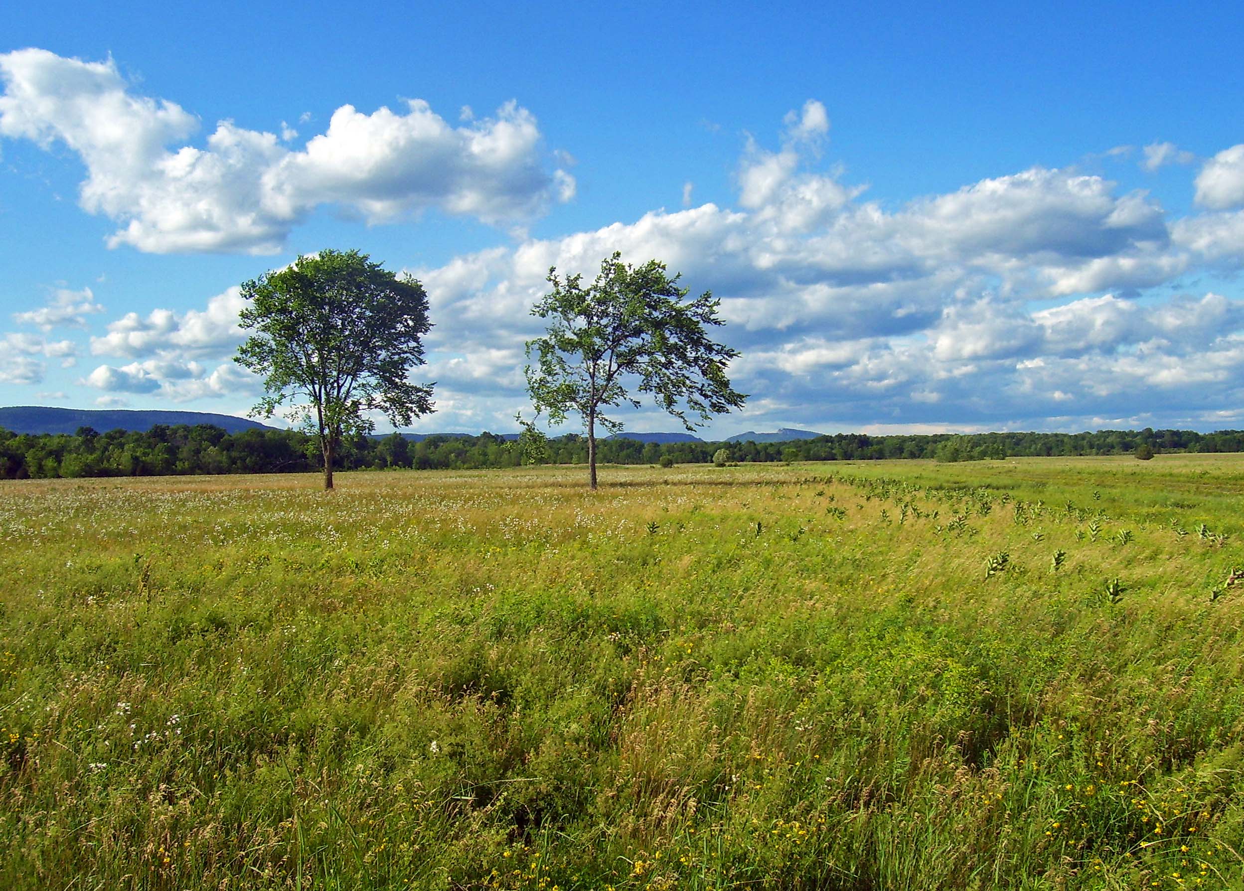
image_caption = View of theShawangunk Ridge from within the Shawangunk Grasslands National Wildlife Refuge.
etymology = "schawan", Dutch transliteration of MunseeLenape for "in the smoky air"
country =USA
country1 =
state =New York
region_type = County
region = Ulster
district_type = Town
district = Shawangunk
location = Galeville
lat_d = 41
lat_m = 38
lat_s = 14
lat_NS = N
long_d = 74
long_m = 12
long_s = 17
long_EW = W
elevation =
area_imperial = 0.84
area1_imperial =
area1_type =
length_imperial = 1
length_orientation = N-S
width_imperial = 1.1
width_orientation = E-W
highest =
highest location = Along Hoagerburgh Road in NW corner
highest_lat_d = 41
highest_lat_m = 38
highest_lat_s = 32
highest_lat_NS = N
highest_long_d = 74
highest_long_m = 13
highest_long_s = 01
highest_long_EW = W
highest_elevation_imperial = 380
lowest =
lowest_location = unnamed stream on eastern border
lowest_lat_d = 41
lowest_lat_m = 38
lowest_lat_s = 22
lowest_lat_NS = N
lowest_long_d = 74
lowest_long_m = 11
lowest_long_s = 55
lowest_long_EW = W
lowest_elevation_imperial = 260
biome = Temperate grassland
biome_share = 71
biome1 = Temperate woodland
biome1_share = 29
geology =
geology1 =
plant =Purple milkweed
plant1 =Coontail
animal =Bobolink
animal1 =Savannah sparrow
animal2 =Grasshopper sparrow
animal3 =Upland sandpiper
animal4 =horned lark
animal5 =Eastern meadowlark
animal6 =Short-eared owl
established_type =
established = 1999
established1_type =
established1 =
management_body =U.S. Fish and Wildlife Service
management_location =Wallkill River National Wildlife Refuge
management_lat_d = 41
management_lat_m = 12
management_lat_s = 04
management_lat_NS = N
management_long_d = 74
management_long_m = 33
management_long_s = 59
management_long_EW = W
management_elevation = 540
visitation = 5,500
visitation_note = PDFlink| [http://library.fws.gov/CCPs/SG-Final/Chapter3.pdf Shawangunk Grasslands National Wildlife Refuge, Comprehensive Conservation Plan (CCP), Chapter 3] ,|701 KiB 3-8, retrieved July 17, 2007.]
visitation_year =
free_type =
free =
free1_type =
free1 =

map_locator_x =
map_locator_y =
map_size = 300
map_caption = Location of Shawangunk Grasslands National Wildlife Refuge
within New York State
map_locator = New York
map1 = Shawangunk Grasslands NWR USFWS map.png
showing land types and boundaries
map_first =
website = http://www.fws.gov/northeast/shawangunk/wildlife refuge located in Ulster County,New York ,USA .Formerly the Galeville Military Airport, it was decommissioned in 1994 and turned over to theUnited States Fish and Wildlife Service in 1999. It serves as a waypoint for grassland-dependent migratory birds.History
The 565-acre (2.1 km²) refuge first became U.S. federal property in the early 1940s, when the U.S. Army bought what was then
swamp land and filled it in with soil from the nearbyflood plain s to build an airbase to meet its sudden need to train pilots as a result ofWorld War II .cite web |url=http://www.fws.gov/northeast/shawangunk/history.htm|title=History |accessdate=2007-07-18 |format= |work=Shawangunk Grasslands National Wildlife Refuge] It stopped using the base years after the war, in the early 1970s, and in later years it would be variously used by the nearbyUnited States Military Academy and as a training facility by theFBI Rothbaum, Rebecca; June 20, 2002; " [http://cityguide.pojonews.com/fe/DayTrips/stories/dt_shawangunk_grasslands.asp Wildlife lives on in Shawangunk Grasslands] "; "Poughkeepsie Journal "; retrieved July 18, 2007.] and U.S. Marshals Service.CCP, 3-6.]In 1994 the Department of Defense decided it no longer needed the property. Five years later, after a protracted struggle with the Town of Shawangunk, which had wanted to develop the land as a park (and was eventually granted 55 acres (22 ha) for that purpose, today Galeville Park), it was conveyed to the
U.S. Fish and Wildlife Service (FWS), which had wanted to protect the land as one of the state's top ten areas for grassland-dependent migratory birds. It is today managed as a subunit of theWallkill River National Wildlife Refuge , 35 miles (56 km) to the south.Recently the FWS began
mowing and deshrubbing the 350 acres (1.4 km²) that makes up the refuge's core grasslands. This is essential for the grasslands would revert to the original wooded swamp if left untended.cite web |url=http://www.fws.gov/northeast/shawangunk/management.htm |title=Grassland Management |accessdate=2007-07-18 |format= |work=Shawangunk Grasslands National Wildlife Refuge]Geography
The Shawangunk Grasslands National Wildlife Refuge is situated in the central portion of the town, closer to Wallkill than Walker Valley. It is a roughly rectangular parcel that sits slightly west of the
Wallkill River , just below the crest of the divide between it and itstributary Shawangunk Kill , itself a relatively unspoiled stream and important habitat the FWS has been working to protect. [http://training.fws.gov/library/pubs5/web_link/text/sha_kill.htm#Shawangunk%20Kill Shawangunk Kill] retrieved from training.fws.gov July 21, 2007.] The site is roughly bounded by Hoagerburgh Road (Ulster County 18) on the west, Albany Post Road (Ulster County 9) on the east, Long Lane (Ulster County 18A) on the north (where the town park is located and Bates Lane to the south. Public access is provided near the southwest corner, off Hoagerburgh.The central area of the property, the former airport, is bounded on all sides by woodland and shrubland (except for a small corridor around the main public access road) which makes up 165 acres (66 ha) of the total. The 400 acres (1.6 km²) that account for the core grassland also boast the former airport's 3,500-foot–long (1,067 m)
runway s and equivalenttaxiway s, taking up about 30 acres (12 ha) along the southern and western bounds of the grasslands. From this open space, it is possible to see much of the surrounding area's scenic highlights, particularly theShawangunk Ridge to the west.Geology
Like much of the
Hudson Valley , the Shawangunk Grasslands show the signs of glaciation during the last Ice Age, even though they were created much more recently through human action. Thetopsoil in the grasslands contains a high level ofclay , which forms a barrier to most water filtering downward. Throughout the entire refuge, thewater table is at least 3 feet (1 m) below the surface. Frequent freezing and melting during the winter results in pit-and-hummock topography throughout much of the refuge.CCP, 3-8.]Ecology and biology
The grasslands created by the airport's construction are one of only two such locations in the region that can support the 12 species of birds dependent on them. Some of them, according to the FWS, need at least 10-20 acres (4-8 ha), per nesting pair. A total of 151 bird species have been documented in the refuge, including 58 that use it for breeding.CCP, 3-15.]
Fauna
The Shawangunk Grasslands are especially important to these grassland-dependent species:
*
Bobolink
*Eastern meadowlark
*Grasshopper sparrow
*Horned lark
*Northern harrier
*Savannah sparrow
*Short-eared owl
*Upland sandpiper In addition several
hawk andfalcon species (not grassland-dependent) have been seen at the siteCCP, 3-17.] , andblack-billed cuckoo andwood thrush have been nesting in the woodland portions.PDFlink| [http://library.fws.gov/CCPs/SG-Final/Chapter4.pdf CCP Chapter 4: Management Direction and Implementation] |805 KiB , 4-19; retrieved July 17, 2007.] Non-bird species that have settled into the habitat include severalturtle species, small-mouthed bass and sunfish in the one small pond on the siteCCP, 3-14.] andwhite-tailed deer in the woodlands.The FWS has also been alerted to the possibility that
Indiana bat s, a federalendangered species , may be exploiting opportunities provided by the refuge. Ahibernaculum of 30,000 bats has been reported 18 miles (29 km) to the northeast, and there is evidence that some have roosted closer to the refuge. The agency has been monitoring the refuge to see if any Indiana bats begin to use dead trees asroost ing sites or begin to forage on the site.CCP, 3-11, 3-12.]Flora
While the refuge is protected primarily for the bird life, several rare or uncommon
plant species have also been found in the grasslands, whereKentucky bluegrass is the dominant speciesCCP, 4-14]Frank's sedge ,small-flowered agrimony ,purple milkweed ,small white aster ,Bush's sedge ,coontail andwatermeal .CCP, 3-12.] A few tree species, such aswhite ash ,American elm ,eastern red cedar , andpin oak , also flourish in those sections. The woodlands on the periphery are dominated by several oak species,red maple ,sugar maple ,shagbark hickory andtulip tree s.The grasslands have also been inviting for severalinvasive species , most notablypurple loosestrife , butgoldenrod andgray dogwood as well. FWS's mowing and other grassland-preservation efforts are aimed at removing or controlling those species.Management
In 2002, the Fish and Wildlife Service finished its first final Comprehensive Conservation Plan for the Shawangunk Grasslands. Its primary goal in managing the area is to preserve and, where possible, extend the existing grassland.CCP, 4-10.] By mowing, deshrubbing and continuing to work with local farmers who are allowed to graze animals on the land and
hay it under special use permits, it hopes to maintain a diverse enough selection of grasses for all species.CCP, 4-10 through 4-15.] Similarly, one mature tree per 10 acres (4 ha) of grassland will be maintained for predatory bird species.CCP, 4-16.] In the longer term, FWS plans to create up to 30 more acres (12 ha) of grassland by removing the runway pavement and restoring the original cover. An 8-foot (2 m) wide strip ofconcrete would be left for use as a publictrail . While grasses are already beginning to grow through cracks in the runways, the agency would prefer not to wait as aircraft continue to make illegal landings at the refuge, disturbing the birds, despite markings on the runways themselves and on aviation charts of the area indicating that the facility is closed. It has not yet determined how this will be done in the most environmentally sensitive fashion.CCP, 4-17 and 4-18.] Similarly, it hopes to restore the original stream pattern through the property by removing theculvert s and other reroutings necessary for the construction of the airfield.CCP, 4-20, 4-21.] Since the woodlands surrounding the grasslands cannot be converted into grasslands, FWS will maintain them as such. The 26 acres (10 ha) of grass and shrublands within the woods will be allowed to return to woodland as well. They have become important habitat as well.CCP, 4-19, 20.]FWS has also committed itself to exploring a number of ways to control the invasive plant species in the refuge, such as
herbicide s, releasingbeetle andweevil species that feed on the invaders and controlled burns in addition to the methods it already employs. Its goal is to reduce their presence to less than 10% of the refuge within 10 years.CCP, 4-20.]Some of its employees have expressed concerns about whether any pollutants might be left over from previous military use of the site, particularly around a communications center demolished in 1973. While the agency does not presently believe there is any cause for concern, it will be monitoring the situation and plans an environmental assessment.
Partner organizations
The FWS has credited other organizations, public and private, with helping it to fulfill its goals for the refuge. The former is represented by its state-level counterpart, the
New York State Department of Environmental Conservation (NYSDEC), which has shared data with it, participated in the planning process and works with local communities to protect wildlife habitat. Among the latter, the local and stateAudubon Society chapters advocated strongly for the area's protection, since the society had declared the airport site an Important Bird Area in 1998.cite web |url=http://iba.audubon.org/iba/viewSiteProfile.do?siteId=807&navSite=state |title=Site Profile: Shawangunk Grasslands |accessdate=2007-07-21 |format= |work= .] Other organizations have played supporting roles by helping to perform management tasks and raising awareness. There is as yet no Friends of Shawangunk Grasslands National Wildlife Refuge as there is at other refuges, but FWS would like for one to be formed.CCP, 3-9, 10.]Recreation
While the refuge is easily accessible to the public, activities within it are strictly limited to those that are wildlife-dependent: walking,
nature photography ,birdwatching and in wintersnowshoe ing andcross-country skiing .Jogging is not allowed, nor is any activity that would bring other animals (such as dogs or horses) or motorized vehicles into the area, since that would likely disturb the nesting birds.CCP, 4-5.] All visitors must remain on the paved roads or runways. The refuge is open from one hour before sunrise to one hour after sunset year-round.CCP, 4-9.]Among the motorized vehicles banned from the refuge are
radio-controlled aircraft . Model airplane enthusiasts, who took to the site and its abandoned runways before it was transferred to FWS, had hoped to continue to be allowed to do so under its management. Many of them wrote in with public comments favoring their hobby, saying wild birds and model airplanes could indeed coexist as they had for thirty years of model aviation at the former airportPDFlink| [http://www.drchristine.com/rccr/news/0203.pdf Airflow, March-April 2002 issue of newsletter of the Radio Control Club of Rochester] |417 KiB , retrieved July 21, 2007.] . While eventually 90% of the comments that addressed it supported model airplaning, FWS did not believe that it was compatible with the goal of preserving a safe habitat for the birds, and officially banned it.Academy of Model Aeronautics president Carl Maroney charged that the agency had made up its mind before soliciting public input.cite news |first=Paul |last=Brooks |coauthors=Wayne Hall |title=Birds and toy planes won't mix at refuge |url=http://archive.recordonline.com/archive/2002/02/24/pbnoplan.htm |work= |publisher="Times-Herald Record " |date=February 24 ,2002 |accessdate=2007-07-21 ]FWS was also criticized by
animal rights groupscite web |url=http://ga0.org/indefenseofanimals/alert-description.html?alert_id=4123062 |title=Stop Bow Hunting in National Wildlife Refuge |accessdate=2007-07-21 |format= |work= ] for its decision to allowbowhunting of deer on the refuge during the state season in the fall, the only hunting it decided was compatible with the refuge's mission. Most bowhunters, it said, will be usingtree stand s on the perimeter and will only need to enter the site briefly to retrieve any kills. It will be administered under a special fee permit system. Fishing will also be permitted in the refuge's pond, but it will not be stockedCCP, 4-6.] although it may be expanded if it proves to be a popular enough activity.CCP, 4-29] Currently, the agency estimates the refuge receives about 5,500 visitors a year, contributing $257,840 to the local economy. Most of them have been birdwatchers, many drawn by the chance to watch the short-eared owl, one of the few owls that hunt in daylight.cite news |first=Wayne |last=Hall |authorlink= |coauthors= |title= Wintering owls take to the skies at dusk |url=http://archive.recordonline.com/archive/2004/12/18/wayne18.htm |work= |publisher="Times-Herald Record " |date=December 28 ,2004 |accessdate=2007-07-21 ] Ultimately the agency hopes to provide a more complete trail system, possibly connecting to the town park and allowing better wildlife viewing. It would like to expand the current parking area and provide an interior contact point for the public, with one employee at the refuge at all times.CCP, maps 4-1 and 4-2, pages 4-11, 12. Also see text at 4-24, 25 and 26.]References
External links
* [http://www.fws.gov/northeast/shawangunk/ Preserve webpage]
Wikimedia Foundation. 2010.