- City of Leeds
-
For the local government district in existence from 1835 to 1974, see County Borough of Leeds.
City of Leeds — City & Metropolitan borough — 
Coat of armsMotto: "Pro Rege et Lege" "For King and the law"
Leeds shown within England
Coordinates: 53°47′59″N 1°32′57″W / 53.79972°N 1.54917°W Sovereign state United Kingdom Constituent country England Region Yorkshire and the Humber Ceremonial county West Yorkshire Admin HQ Leeds Borough Charter 1207 Town Charter 1626 City status 1893 City of Leeds Met. District created 1974 Government - Type Metropolitan borough, City - Governing body Leeds City Council - Lord Mayor Cllr Rev'd Alan Taylor - Leader of the Council Cllr Keith Wakefield (Labour) - Chief Executive Tom Riordan - MPs: Rachel Reeves (L)
Hilary Benn (L)
Alec Shelbrooke (C)
Ed Balls (L)
Fabian Hamilton (L)
George Mudie (L)
Greg Mulholland (LD)
Stuart Andrew (C)Area - Total 213 sq mi (551.72 km2) Highest elevation[1] 1,115 ft (340 m) Lowest elevation[2] 33 ft (10 m) Population (2010 est.) - Total 798,800 (Ranked 2nd) - Density 3,574/sq mi (1,380/km2) - Ethnicity
(2001 census)[3]89.1% White
5.4% Asian or Asian British
2.0% Black or Black British
1.7% Mixed Race
1.8% Chinese and otherTime zone Greenwich Mean Time (UTC+0) - Summer (DST) British Summer Time (UTC+1) Postcode areas LS, WF Area code(s) 0113, 01924, 01937, 01943, 01977 ISO 3166-2 GB-LDS ONS code 00DA NUTS 3 UKE42 OS grid reference SE296338 Euro. Parlt. Const. Yorkshire & the Humber Website www.leeds.gov.uk Coordinates: 53°47′59″N 1°32′57″W / 53.79972°N 1.54917°W The City of Leeds is a local government district of West Yorkshire, England, governed by Leeds City Council, with the status of a city and metropolitan borough. The metropolitan district includes Leeds and the towns of Farsley, Garforth, Guiseley, Horsforth, Morley, Otley, Pudsey, Rothwell, Wetherby and Yeadon.[4] It has a population of 798,800 (2010 est.) and is the second largest local government district in England by population; and the second largest metropolitan district by area.
The current city boundaries were set on 1 April 1974 by the provisions of the Local Government Act 1972, as part a reform of local government in England. The city is a merger of eleven former local government districts; the unitary City and County Borough of Leeds combined with the municipal boroughs of Morley and Pudsey, the urban districts of Aireborough, Garforth, Horsforth, Otley and Rothwell, and parts of the rural districts of Tadcaster, Wharfedale and Wetherby from the West Riding of Yorkshire.
For its first 12 years the city had a two-tier system of local government; Leeds City Council shared power with the West Yorkshire County Council. Since the Local Government Act 1985 Leeds City Council has effectively been a unitary authority, serving as the sole executive, deliberative and legislative body responsible for local policy, setting council tax, and allocating budget in the city, and is a member of the Leeds City Region Partnership. Thc City of Leeds is divided into 31 civil parishes and a single unparished area.
Contents
History
Main articles: History of Leeds and History of local government in YorkshireBackground
The Borough of Leeds was created in 1207, when Maurice Paynel, lord of the manor, granted a charter covering a small area adjacent to a crossing of the River Aire, between the old settlement centred on Leeds Parish Church to the east and the manor house and mills to the west. In 1626 a charter was granted by Charles I, incorporating the entire parish as the Borough of Leeds; it was reformed by the Municipal Corporations Act 1835. The parish and borough included the chapelries of Chapel Allerton, Armley, Beeston, Bramley, Farnley, Headingley cum Burley, Holbeck, Hunslet, Leeds, Potternewton and Wortley. The borough was located in the West Riding of Yorkshire and gained city status in 1893. When a county council was formed for the riding in 1889, Leeds was excluded from its area of responsibility and formed a county borough. The borough made a significant number of territorial expansions, expanding from 21,593 acres (87.38 km2) in 1911 to 40,612 acres (164.35 km2) in 1961;[5] adding in stages the former area of the Roundhay, Seacroft, Shadwell and Middleton parishes and gaining other parts of adjacent districts.
Formation
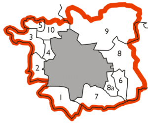
A review of local government arrangements completed in 1969 proposed the creation of a new large district centered on Leeds, occupying 317,000 acres (1,280 km2) and including 840,000 people. The proposed area was significantly reduced in a 1971 white paper; and within a year every local authority to be incorporated into it protested or demonstrated.[6] The final proposal reduced the area further and following the enactment of the Local Government Act 1972, the county borough was abolished on 1 April 1974 and its former area was combined with that of the municipal boroughs of Morley and Pudsey; the urban districts of Aireborough, Horsforth, Otley, Garforth and Rothwell; and parts of the rural districts of Tadcaster, Wetherby and Wharfedale. The new district gained both borough and city status, as had been held by the county borough; and forms part of the county of West Yorkshire.
Formation of the metropolitan district in 1974 The former county borough is shaded in grey. Other areas: - Municipal Borough of Morley
- Municipal Borough of Pudsey
- Aireborough Urban District
- Horsforth Urban District
- Otley Urban District
- Garforth Urban District
- Rothwell Urban District
- 8a. Tadcaster Rural District (part)
- Wetherby Rural District (part)
- Wharfedale Rural District (part)
Geography
The district and its settlements are situated in the eastern foothills of the Pennines astride the River Aire whose valley, the Aire Gap, provides a road and rail corridor that facilitates communications with cities to the west of the Pennines. The district extends 15 miles (24 km) from east to west and 13 miles (21 km) from north to south; with over 65% covered with green belt land. The highest point, at 1,115 feet (340 m), is at its north western extremity on the eastern slopes of Rombalds Moor, better known as Ilkley Moor, on the boundary with the City of Bradford. The lowest points are at around 33 feet (10 m), in the east: where River Wharfe crosses the boundary with North Yorkshire south of Thorp Arch Trading Estate and where the River Aire (at this point forming the City of Wakefield boundary) meets the North Yorkshire boundary near Fairburn Ings. To the north and east Leeds is bordered by North Yorkshire: Harrogate district to the north and Selby district to the east. The remaining borders are with other districts of West Yorkshire: Wakefield to the south, Kirklees to the south west, and Bradford to the west.[7]
Governance
Main article: Leeds City CouncilLeeds City Council is the local authority of the district. The council is composed of 99 councillors, three for each of the city's wards. Elections are held three years out of four, on the first Thursday of May. One third of the councillors are elected, for a four year term, in each election. 2004 saw all seats up for election due to boundary changes. It is currently run by a Labour administration. Before the 2011 election, the council had been under no overall control since 2004. The Chief Executive of Leeds City Council is Tom Riordan while the Leader of the Council is Councillor Keith Wakefield of the Labour Party. West Yorkshire does not have a county council, so Leeds City Council is the primary provider of local government services. The district forms part of the Yorkshire and the Humber region of England.
The district consists of the unparished area of Leeds and 31 civil parishes. These form the lowest tier of local government[8] and absorb some limited functions from Leeds City Council in their areas. The councils of Horsforth, Morley, Otley and Wetherby are town councils.[9] The 27 other civil parishes are:
- Bramham cum Oglethorpe
- Bramhope and Carlton
- Clifford
- Collingham with Linton
- Drighlington
- East Keswick
- Gildersome
- Great and Little Preston
- Harewood
- Kippax
- Ledsham
- Ledston
- Micklefield
- Pool in Wharfedale
The district is represented by eight MPs (one jointly with Wakefield), for the constituencies of Elmet and Rothwell (Alec Shelbrooke, Conservative); Leeds Central (Hilary Benn, Labour); Leeds East (George Mudie, Labour); Leeds North East (Fabian Hamilton, Labour); Leeds North West (Greg Mulholland, Lib Dem); Leeds West (Rachel Reeves, Labour); Pudsey (Stuart Andrew, Conservative); and Morley and Outwood (Ed Balls, Labour; three wards of this constituency are in Leeds and two in Wakefield). Leeds is within the Yorkshire and the Humber European constituency, which is represented by two Liberal Democrat, one Conservative, one Labour, one UKIP, and one BNP MEPs.[10]. The voting figures for Leeds in the European Parliament election in June 2009 were: Conservative 22.6%, Labour 21.4%, UKIP 15.9%, Lib Dem 13.8%, BNP 10.0%, Green 9.4%[11].
Demography
Leeds compared 2001 UK Census[12] City of Leeds
metropolitan districtYorkshire
and the HumberEngland Population 715,402 4,964,833 49,138,831 White 91.8% 93.5% 90.9% Asian 4.5% 4.5% 4.6% Black 1.4% 0.7% 2.3% As of the 2001 UK census, the district had a total population of 715,402.[12] Of the 301,614 households in Leeds, 33.3% were married couples living together, 31.6% were one-person households, 9.0% were co-habiting couples and 9.8% were lone parents, following a similar trend to the rest of England.[13] The population density was 1,967 /km2 (5,090 /sq mi)[13] and for every 100 females, there were 93.5 males. Of those aged 16–74, 30.9% had no academic qualifications, higher than the 28.9% in all of England.[14] Of the residents, 6.6% were born outside the United Kingdom, lower than the England average of 9.2%.[15]
The majority of people in Leeds identify themselves as Christian.[16] The proportion of Muslims is average for the country.[16] Leeds has the third-largest Jewish community in the United Kingdom, after those of London and Manchester. The areas of Alwoodley and Moortown contain sizeable Jewish populations.[17] 16.8% of Leeds residents in the 2001 census declared themselves as having "no religion", which is broadly in line with the figure for the whole of the UK (also 8.1% "religion not stated").
The crime rate in Leeds is well above the national average, like many other English major cities.[18][19] In July 2006, the think tank Reform calculated rates of crime for different offences and has related this to populations of major urban areas (defined as towns over 100,000 population). Leeds was 11th in this rating (excluding London boroughs, 23rd including London boroughs).[20] The table below details the population of the current area of the district since 1801, including the percentage change since the last available census data.
Population growth in City of Leeds since 1801 Year 1801 1811 1821 1831 1841 1851 1861 1871 1881 1891 1901 1911 1921 1931 1941 1951 1961 1971 1981 1991 2001 Population 94,421 108,459 137,476 183,015 222,189 249,992 311,197 372,402 433,607 503,493 552,479 606,250 625,854 646,119 668,667 692,003 715,260 739,401 696,732 716,760 715,404 % change – +14.87 +26.75 +33.13 +21.40 +12.51 +24.48 +19.67 +16.44 +16.12 +9.73 +9.73 +3.23 +3.24 +3.49 +3.49 +3.36 +3.38 −5.77 +2.87 −0.19 Source: Vision of Britain[21] Economy
Main article: Economy of LeedsLeeds has a diverse economy with the service sector now dominating over the traditional manufacturing industries. It is the location of one of the largest financial centres in England outside London. New tertiary industries such as retail, call centres, offices and media have contributed to a high rate of economic growth. This is a chart of trend of regional gross value added of Leeds at current basic prices with figures in millions of British pounds sterling.[22]
Year Regional Gross
Value Added4Agriculture1 Industry2 Services3 1995 8,713 43 2,652 6,018 2000 11,681 32 2,771 8,878 2003 13,637 36 3,018 10,583 Education
Education Leeds, a non-profit company owned by Leeds City Council, has provided educational services since 2001.[23]
Transport
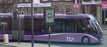 FTR bus service
 Main article: Transport in Leeds
Leeds city centre is connected to the National Rail network at Leeds railway station. Public transport in West Yorkshire is coordinated by the West Yorkshire Passenger Transport Executive, under the control of a joint-board of local authorities in the county and including Leeds City Council. The transport authority is notable for providing a zero-fare bus service in Leeds city centre, the FreeCityBus.
Twin towns
Leeds City Council has several twinning or partnership arrangements:
It also has "strong contacts" with the following cities "for the purposes of ongoing projects":[26]
 Stockholm, Sweden
Notes and references
- Notes
- ^1 includes hunting and forestry
- ^2 includes energy and construction
- ^3 includes financial intermediation services indirectly measured
- ^4 Components may not sum to totals due to rounding
- References
- ^ Max at SE140445 Hawksworth Moor in extreme west of city
- ^ Min at points where city boundary crosses Rivers Aire and Wharfe in extreme east.
- ^ National Statistics: Neighbourhood Statistics. "Leeds (Local Authority): Key Figures for People and Society: Population and Migration". http://www.neighbourhood.statistics.gov.uk/dissemination/LeadKeyFigures.do?a=3&b=276810&c=leeds&d=13&e=13&g=382985&i=1001x1003x1004&m=0&r=1&s=1206488787312&enc=1. Retrieved 2008-03-25.
- ^ Van den Berg 2006, p. 179.
- ^ Vision of Britain - Leeds MB/CB (historic map) population (area ). Retrieved on 2009-09-24.
- ^ Derek Fraser (1982). A History of modern Leeds. Manchester University Press.
- ^ "Leeds Maps - Leeds City Region". Leeds City Council. http://www.leeds.gov.uk/maps/leeds_cr.html. Retrieved 2009-04-16.
- ^ "Parish and Town Councils". Leeds City Council. http://www.leeds.gov.uk/Council_and_democracy/Councillors_democracy_and_elections/Parish_and_town_councils.aspx. Retrieved 2009-04-01.
- ^ "Leeds civil parish map 2008". Leeds City Council. http://www.leeds.gov.uk/maps/leeds_mpb.html. Retrieved 2009-04-01.
- ^ "Your MEPs". http://www.europarl.org.uk/section/your-meps/findmep?filter0=Yorkshire+%26amp%3B+the+Humber. Retrieved 2011-03-10.
- ^ Rogers, Simon (10 June 2009). "Exactly how well did the BNP do where you live?". Guardian: Data Blog. http://www.guardian.co.uk/news/datablog/table/2009/jun/09/european-elections-elections-2009. Retrieved 2009-07-14.
- ^ a b "Leeds Metropolitan Borough ethnic group". Office for National Statistics. http://neighbourhood.statistics.gov.uk/dissemination/LeadTableView.do?a=7&b=276810&c=Leeds&d=13&e=16&g=382985&i=1001x1003x1004&o=1&m=0&r=1&s=1231357883004&enc=1&dsFamilyId=87. Retrieved 2009-07-22.
- ^ a b "Leeds Metropolitan Borough household composition (households)". Office for National Statistics. http://neighbourhood.statistics.gov.uk/dissemination/LeadTableView.do?a=7&b=276810&c=Leeds&d=13&e=16&g=382985&i=1001x1003x1004&o=1&m=0&r=1&s=1231357883004&enc=1&dsFamilyId=165. Retrieved 2009-07-22.
- ^ "Leeds Metropolitan Borough key statistics". Office for National Statistics. http://neighbourhood.statistics.gov.uk/dissemination/LeadKeyFigures.do?a=7&b=276810&c=Leeds&d=13&e=16&g=382985&i=1001x1003x1004&o=1&m=0&r=1&s=1231357882989&enc=1. Retrieved 2009-07-22.
- ^ "Leeds Metropolitan Borough country of birth data". Office for National Statistics. http://neighbourhood.statistics.gov.uk/dissemination/LeadTableView.do?a=7&b=276810&c=Leeds&d=13&e=16&g=382985&i=1001x1003x1004&o=1&m=0&r=1&s=1231357883004&enc=1&dsFamilyId=85. Retrieved 2009-07-22.
- ^ a b "Leeds Census 2001". http://www.statistics.gov.uk/census2001/profiles/00DA-A.asp.
- ^ M. Freedman (1988) "The Leeds Jewish Community" pp. 161–174 in L. S. Tate (ed) Aspects of Leeds ISBN 1-871647-38-X
- ^ "Crime figures in Leeds". http://www.upmystreet.com/local/police-crime/figures/l/Leeds-4292.html.
- ^ "Crime Statistics for Leeds Apr 2005 - Mar 2006". Home Office. http://www.crimestatistics.org.uk/tool/Default.asp?region=7&force=28&cdrp=106&l1=0&l2=0&l3=0&sub=0&v=36.
- ^ "Urban Crime Rankings". July 2006. Archived from the original on 2008-03-08. http://web.archive.org/web/20080308195432/http://www.reform.co.uk/filestore/pdf/Urban+crime+rankings,+Reform,+July+2006.pdf.
- ^ "Leeds District: total population". Vision of Britain. http://www.visionofbritain.org.uk/data_cube_table_page.jsp?data_theme=T_POP&data_cube=N_TPop&u_id=10057140&c_id=10001043&add=N. Retrieved on 19 December 2008.
- ^ "Regional Gross Value Added". Office for National Statistics. pp. 240–253. http://www.statistics.gov.uk/downloads/theme_economy/RegionalGVA.pdf.
- ^ "Education Leeds – the organisation". EducationLeeds.co.uk. http://www.educationleeds.co.uk/DisplayText.aspx?section=17&pageno=195. Retrieved 2009-07-22.
- ^ "Leeds - Brno partnership". Leeds City Council. http://www.leeds.gov.uk/page.aspx?pageidentifier=74bb3508-0d14-45f3-b7d7-ec8a267c27be. Retrieved 2009-09-24.
- ^ "Brno - Partnerská města" (in Czech). © 2006-2009 City of Brno. http://www.brno.cz/index.php?nav02=1985&nav01=34&nav03=1010&nav04=1016&nav05=1249&nav06=1272. Retrieved 2009-07-17.
- ^ a b "International relations". Leeds City Council. http://www.leeds.gov.uk/About_Leeds/international_relations.aspx. Retrieved 2009-09-24.
- ^ "Leeds - Dortmund partnership". Leeds City Council. http://www.leeds.gov.uk/Advice_and_benefits/Tourism_and_travel/Town_twinning/Leeds__Dortmund_partnership.aspx. Retrieved 2009-09-24.
- ^ "Leeds - Durban partnership". Leeds City Council. http://www.leeds.gov.uk/page.aspx?pageidentifier=6555f52e-1de9-499b-8eda-7b86bf24ac8c. Retrieved 2009-09-24.
- ^ "Leeds - Hangzhou partnership". Leeds City Council. http://www.leeds.gov.uk/page.aspx?pageidentifier=32283a2b-11e6-4257-b018-ca6f95567d1a. Retrieved 2009-09-24.
- ^ "Leeds - Lille partnership". Leeds City Council. http://www.leeds.gov.uk/page.aspx?pageidentifier=ac0a4504-f720-4eff-9376-5bff2a4576a0. Retrieved 2009-09-24.
- ^ "Leeds - Louisville partnership". Leeds City Council. http://www.leeds.gov.uk/page.aspx?pageidentifier=f665edae-e44d-495b-b4e3-0385a941082f. Retrieved 2009-09-24.
- ^ "Leeds - Siegen partnership". Leeds City Council. http://www.leeds.gov.uk/Advice_and_benefits/Tourism_and_travel/Town_twinning/Leeds__Siegen_partnership.aspx. Retrieved 2009-09-24.
- Bibliography
- Burt, Steven; Grady, Kevin (1994), The Illustrated History of Leeds, Breedon Books, ISBN 1 873626 35 5
- Fraser, Derek (1982), A History of Modern Leeds, Manchester University Press, ISBN 9780719007811
- Van den Berg, Leo (2006), The Safe City: Safety and Urban Development in European Cities, Ashgate, ISBN 9780754647232
External links
- Leeds travel guide from Wikitravel
- Leeds City Council Leeds City Council.
- 'Leeds Chamber of Commerce & Industry' Leeds Chamber of Commerce & Industry.
- 'Leeds Initiative' Leeds Initiative city partnership.
- Leodis Leeds Library & Information Service photograph archive.
Leeds Topics Culture Places List of towns, villages, areas and suburbsGovernment City of Leeds • Leeds City CouncilPeople Ceremonial county of West Yorkshire Metropolitan districts City of Bradford • City of Leeds • City of Wakefield • Metropolitan Borough of Calderdale • Metropolitan Borough of KirkleesMajor settlements Batley • Bingley • Bradford • Brighouse • Castleford • Cleckheaton • Denholme • Dewsbury • Elland • Farsley • Featherstone • Garforth • Guiseley • Halifax • Hebden Bridge • Hebden Royd • Heckmondwike • Hemsworth • Holmfirth • Horsforth • Huddersfield • Ilkley • Keighley • Knottingley • Leeds • Meltham • Mirfield • Morley • Mytholmroyd • Normanton • Ossett • Otley • Pontefract • Pudsey • Rothwell • Shipley • Silsden • South Elmsall • Sowerby Bridge • Todmorden • Wakefield • Warley Town • Wetherby • Yeadon
See also: List of civil parishes in West YorkshireTopics Parliamentary constituencies • West Yorkshire Joint Services • Monastic houses • Museums • WindmillsCities of the United Kingdom England Bath · Birmingham · Bradford · Brighton and Hove · Bristol · Cambridge · Canterbury · Carlisle · Chester · Chichester · Coventry · Derby · Durham · Ely · Exeter · Gloucester · Hereford · Kingston upon Hull · Lancaster · Leeds · Leicester · Lichfield · Lincoln · Liverpool · London · Manchester · Newcastle upon Tyne · Norwich · Nottingham · Oxford · Peterborough · Plymouth · Portsmouth · Preston · Ripon · St Albans · Salford · Salisbury · Sheffield · Southampton · Stoke-on-Trent · Sunderland · Truro · Wakefield · Wells · Westminster · Winchester · Wolverhampton · Worcester · York
Scotland Wales Northern Ireland Metropolitan counties and metropolitan districts Greater Manchester 
Merseyside South Yorkshire Tyne and Wear West Midlands West Yorkshire - Bradford
- Calderdale
- Kirklees
- Leeds
- Wakefield
Categories:- Leeds City Region
- Cities in Yorkshire and the Humber
- Local government districts in West Yorkshire
- Metropolitan boroughs
- Leeds
- Local government districts of Yorkshire and the Humber


Wikimedia Foundation. 2010.