- Pons Cestius
-
Pons Cestius
(Pons Gratiani)
The Pons Cestius in its modern formOfficial name Ponte Cestio Carries Tiber Island-Trastevere Crosses Tiber Locale Rome, Italy Design Arch bridge Material Stone Longest span 13.7 m Number of spans 3 Construction end Between 62 and 27 BC (first stone bridge) 
The Roman bridge around 1880, before its reconstruction The Pons Cestius (Italian: Ponte Cestio, meaning "Cestius' Bridge") is a Roman stone bridge in Rome, Italy, spanning the Tiber to the west of the Tiber Island. The original version of this bridge was built around the 1st century BC (some time between 62 and 27 BC), after the Pons Fabricius, sited on the other side of island. Both the ponti Cestius and Fabricius were long-living bridges; however, whereas the Fabricius remains wholly intact, the Ponte Cestio was partly dismantled in the 19th century, with only some of the ancient structure preserved.
The Pons Cestius is the first bridge that reached the right bank of Tiber from the Tiber Island. Whereas the island was long connected with the left bank of the Tiber and the heart of ancient Rome, even before the pons Fabricius, the right bank (Transtiber) remained unconnected until the Cestius was constructed. Several prominent members of the Cestii clan from the 1st century BC are known, but it is uncertain which of them built this bridge.[1]
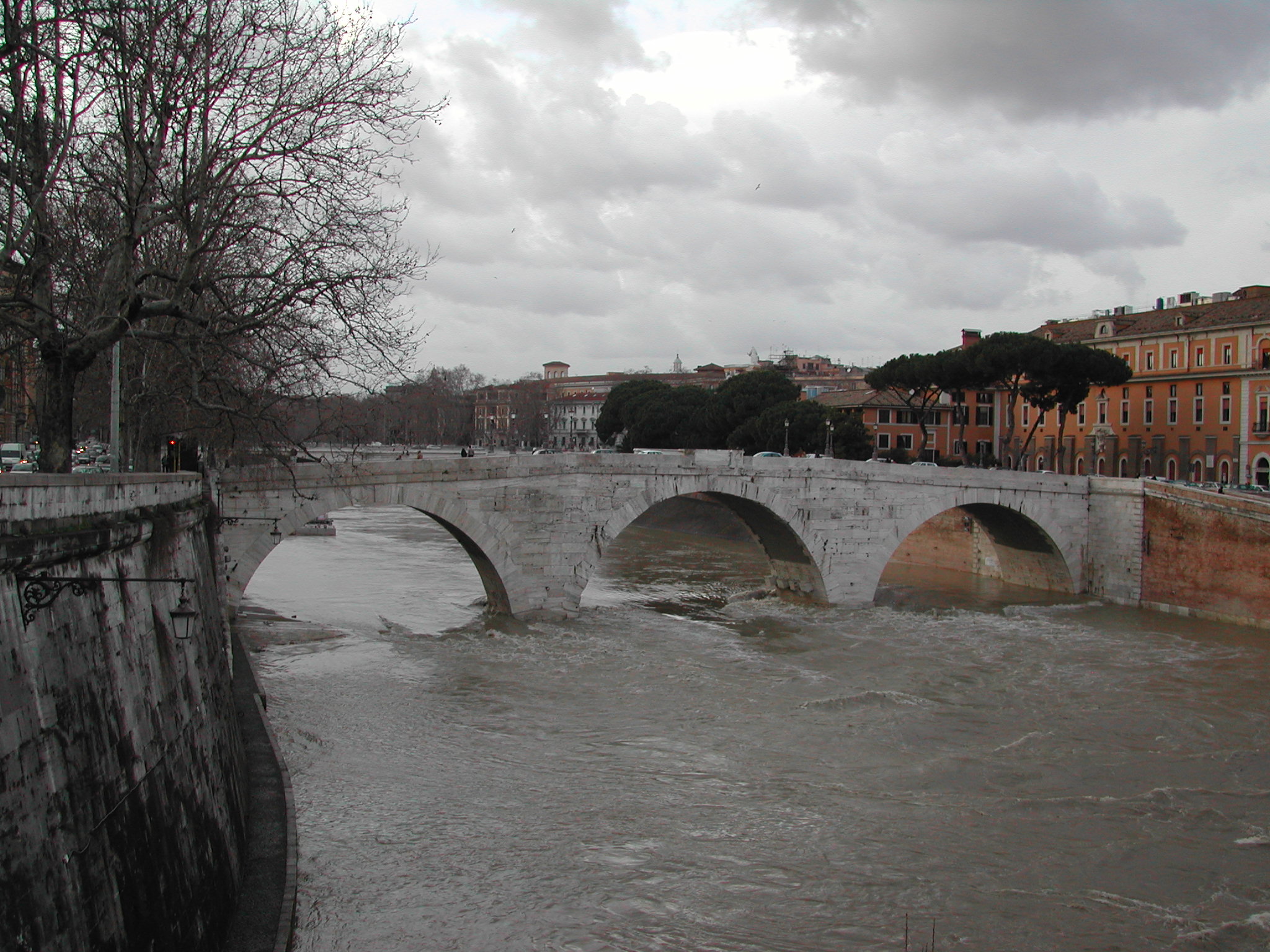
 The Tiber running high, December 2008
In the 4th century the Pons Cestius was rebuilt by the Emperors Valentinian I, Valens and Gratian and re-dedicated in 370 as the Pons Gratiani. The bridge was rebuilt using tuff and peperino, with a facing of travertine. Some of the rebuilding material came from the demolished porticus of the nearby Theatre of Marcellus.[2]
During the building of the walls along the river embankment in 1888–1892, the bridge had to be demolished and rebuilt, as the western channel was widened from 48 to 76 meters. The ancient bridge, which had two small arches, was simply not long enough. A new bridge, with three large arches, was constructed in its stead, with its central arch reusing about two-thirds of the original material.
See also
References
- ^ Samuel Ball Platner. "Pons Cestius (from A Topographical Dictionary of Ancient Rome)". http://penelope.uchicago.edu/Thayer/E/Gazetteer/Places/Europe/Italy/Lazio/Roma/Rome/_Texts/PLATOP*/Pons_Cestius.html.
- ^ Claridge, Amanda (1998). Rome: An Oxford Archaeological Guide. Oxford: Oxford Univ. Press.
Sources
- O’Connor, Colin (1993). Roman Bridges. Cambridge University Press. pp. 66f.. ISBN 0-521-39326-4
External links
 Media related to Pons Cestius at Wikimedia Commons
- LacusCurtius: Pons Cestius
- Pons Cestius at Structurae
- The Waters of Rome: Tiber River Bridges and the Development of the Ancient City of Rome
- Tiber Island information (Italian)
Ancient Bridges on the Tiber (from source to mouth) Upstream: Milvius (Molle) · Ælius (Sant'Angelo) · Neronianus† · Agrippae (Sisto) · Aurelius†
After the Island: Fabricius · Cestius · Æmilius (Rotto)† · Sublicius† · Probi††: partly or wholly underwater or demolished · Names are in the original Latin; in parentheses are the Italian names that differ significantly
Roman bridges England 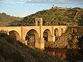
France Pont Ambroix • Pont de Bornègre • Pont Flavien • Pont du Gard • Pont Julien • Pont sur la Laye • Pont des Marchands • Pont Serme • Roman Bridge (Saint-Thibéry) • Roman Bridge (Vaison-la-Romaine) Germany Iran Band-e Kaisar Italy Pons Aemilius • Pons Agrippae • Ponte Altinate • Pons Cestius • Pons Fabricius • Pons Neronianus • Pons Probi • Pons Sublicius • Pont d'Aël • Pont de Pierre (Aosta) • Pont-Saint-Martin • Ponte d'Augusto (Rimini) • Ponte Corvo • Ponte del Gran Caso • Ponte Milvio • Ponte Molino (Padua) • Ponte Nomentano • Ponte Pietra (Verona) • Ponte di Pioraco • Ponte di Quintodecimo • Ponte Salario • Ponte San Lorenzo • Ponte Sant'Angelo • Susegana Bridge Lebanon Leontes Bridge Portugal Ponte de Rubiães • Ponte Nova da Cava da Velha • Roman Bridge (Chaves) Romania Spain Acueducto de los Milagros • Alcántara Bridge • Alcántara Bridge (Toletum) • Alconétar Bridge • Aqüeducte de les Ferreres • Puente Romano (Mérida) • Segovia Aqueduct Bridge Syria Bridge at Nimreh • Gemarrin Bridge • Kharaba Bridge Turkey Aesepus Bridge • Arapsu Bridge • Bridge at Oinoanda • Constantine's Bridge (Mysia) • Eurymedon Bridge (Aspendos) • Eurymedon Bridge (Selge) • Karamagara Bridge • Kemer Bridge • Limyra Bridge • Makestos Bridge • Nysa Bridge • Penkalas Bridge • Pergamon Bridge • Sangarius Bridge • Severan Bridge • Taşköprü (Adana) • Valens Aqueduct Bridge • White Bridge (Mysia)
Coordinates: 41°53′24.8″N 12°28′38″E / 41.890222°N 12.47722°ECategories:- Bridges in Rome
- Roman bridges in Italy
- Deck arch bridges
- Stone bridges
- 1st-century BC bridges


Wikimedia Foundation. 2010.