- Mold, Flintshire
-
Coordinates: 53°09′58″N 3°07′59″W / 53.166°N 3.133°W
Mold Welsh: Yr Wyddgrug 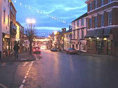
Mold High Street, with Christmas lights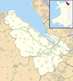
 Mold
Mold
Mold shown within FlintshirePopulation 9,568 (2001 Census)[1] OS grid reference SJ237640 Principal area Flintshire Ceremonial county Clwyd Country Wales Sovereign state United Kingdom Post town MOLD Postcode district CH7 Dialling code 01352 Police North Wales Fire North Wales Ambulance Welsh EU Parliament Wales UK Parliament Delyn Welsh Assembly Delyn List of places: UK • Wales • Flintshire Mold (Welsh: Yr Wyddgrug) is a town in Flintshire, North Wales, on the River Alyn. It is the administrative seat of Flintshire County Council, and was also the county town of Clwyd from 1974 to 1996. According to the 2001 UK Census, it has a population of 9,568.[1]
Contents
Origin of the name
The placename Mold originates from the Norman-French "mont-hault" (high hill), and is recorded as Mohald in a document of 1254. The Welsh language placename of Yr Wyddgrug is recorded as Gythe Gruc in a document of 1280-1, and comes from the words "Yr" (the), "gwydd" (tomb, sepulchre) and "crug" (mound).
History
The town grew up around the now ruined Mold Castle, built by Robert de Montalt in around 1140, and the site of frequent battles between English and Welsh forces. The castle was apparently captured for the Welsh by Owain Gwynedd in 1146, though it is equally possible that reports of this event refer to a castle of the same name in mid-Wales. It was lost to Henry II of England in 1167, and recaptured by the Welsh in 1201. A further period of English authority commenced in 1241, when Dafydd ap Llywelyn yielded possession of the castle to the de Montalt family; however he recaptured it in 1245.
About a mile west of the town is Maes Garmon, (The Field of Germanus), the traditional site of the Alleluia Victory by British forces led by Germanus of Auxerre over invading Picts and Scots, fought shortly after Easter 430.
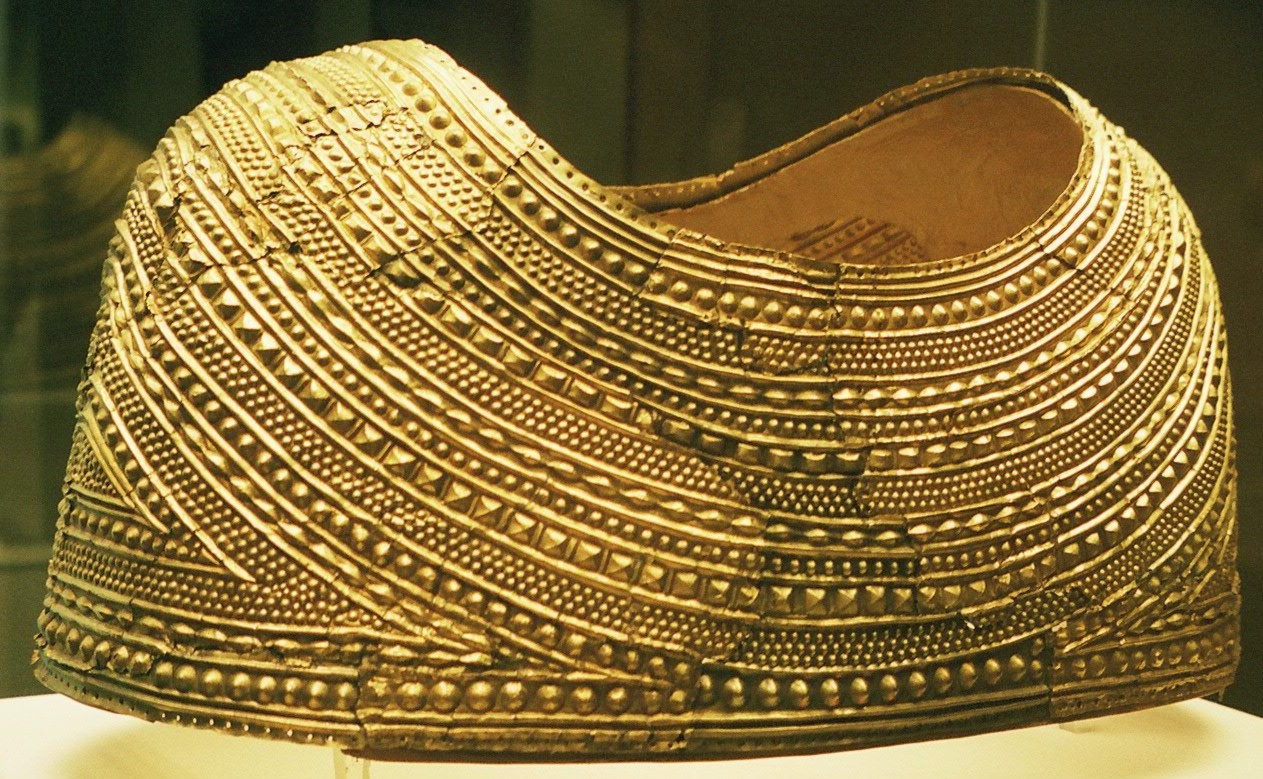
 The Mold cape
In 1833, workmen digging a prehistoric mound at Bryn yr Ellyllon (Fairies' or Goblins' Hill) discovered a unique golden cape, which dates from 1900-1600 BC in the Bronze Age. The cape weighs 560 g and was produced from a single gold ingot about the size of a golf ball. Unfortunately it was broken when found and the fragments were shared out among the workmen, with the largest piece going to Mr Langford, tenant of the field in which the mound stood. The find was recorded by the vicar of Mold and came to the notice of the British Museum. In 1836 Langford sold his piece to the Museum and subsequently most of the pieces were recovered, though there is a tradition that the wives of some of the workmen sported new jewellery after the find! Restored, the cape now forms one of the great treasures of the British Museum in London.[2][3]
Mold hosted the National Eisteddfod in 1923, 1991 and 2007. There was an unofficial National Eisteddfod event in 1873.
Mold was linked to Chester by the Mold Railway, with a large British Rail station together with adjacent marshalling yards and engine sheds; however, these closed when Croes Newydd at Wrexham was opened. The station was closed in 1962 in the Beeching Cuts of the early 1960s, though the track survived until the mid 1980s to serve the Synthite chemical works. A Tesco supermarket was built on the station site in the 1990s.
The Mold Riot
In the summer of 1869 a riot occurred in the town[4] which had considerable effect on the subsequent policing of public disturbances in Great Britain. On 17 May 1869, John Young, the English manager of the nearby Leeswood Green colliery, angered his workers by announcing a pay cut. He had previously strained relationships with them by banning the use of the Welsh language underground. Two days later, following a meeting at the pithead, the miners attacked Young before frogmarching him to the police station. Seven men were arrested and ordered to stand trial on 2 June. All were found guilty and the convicted ringleaders, Ismael Jones and John Jones, were sentenced to a month's hard labour. A large crowd had assembled to hear the verdict, and the Chief Constable of Flintshire had arranged for police from all over the county and soldiers from Chester to be present. As the convicts were being transported to the railway station the crowd grew restive and threw missiles at the officers. The soldiers opened fire on the crowd, killing four people[4] including one completely innocent bystander. Although he strenuously denied the connection, Daniel Owen's first novel, Rhys Lewis, published in instalments in 1882-1884, was heavily based on these events. Daniel Owen was a writer who lived in Mold.
Community
Attractions in Mold include St Mary's Church (a 15th century parish church), a small museum and the regional arts centre, Clwyd Theatr Cymru.
Mold is a cittaslow (slow food town), which became the first town in Wales to achieve this distinction.[5] Mold has a market every Wednesday and Saturday at which much fresh produce can be obtained. For speciality and fresh local food, the Celyn Farmers' Market is held on the first Saturday of every month in Mold (and it continues, as it started, on the third Sunday of the month in nearby Northop). There are several producers in the Mold markets who also appear regularly at the famous Borough Market in London. The Mold Food & Drink Festival is held during September each year. The food festival has a central event area on the edge of the town centre, and many central and nearby businesses contribute to the event.
Mold has two secondary schools that serve the town and the surrounding villages. With approximately 1,800 pupils, the Alun School is the largest school in the county. It is adjoined by the only Welsh language secondary school in Flintshire, Ysgol Maes Garmon.
Climate
As with the rest of the British Isles, Mold experiences a maritime climate with cool summers and mild winters. The nearest official Met Office weather station for which online records are available is at Loggerheads,[6] about 3 miles west of the town centre.
The highest temperature recorded in the area was 31.7 °C (89.1 °F) during august 1990.[7] However, the warmest day is typically around 26.4 °C (79.5 °F)[8] in an 'average' year, one of around 4 days[9] to reach a temperature of 25.1 °C (77.2 °F) or above.
The lowest temperature recorded was −18.7 °C (−1.7 °F) during december 1981.[10] In a more typical year the coldest night averages around −9.7 °C (14.5 °F),[11] with a total of 62.1 frosty nights.[12]
Rainfall averages 925mm per year, with almost 152 days reporting at least 1mm of precipitation.[13]
Climate data for Loggerheads 210m asl, 1971-2000, Extremes 1961-2005 (Weather Station 3 Miles West of Mold) Month Jan Feb Mar Apr May Jun Jul Aug Sep Oct Nov Dec Year Record high °C (°F) 15.7
(60.3)16.7
(62.1)22.2
(72.0)23.2
(73.8)25.0
(77.0)29.4
(84.9)30.1
(86.2)31.7
(89.1)27.2
(81.0)23.9
(75.0)17.6
(63.7)14.6
(58.3)31.7
(89.1)Average high °C (°F) 6.3
(43.3)6.4
(43.5)8.5
(47.3)10.8
(51.4)14.4
(57.9)16.7
(62.1)19.0
(66.2)18.6
(65.5)15.8
(60.4)12.4
(54.3)8.8
(47.8)7.1
(44.8)12.07
(53.72)Average low °C (°F) 0.3
(32.5)0.2
(32.4)1.7
(35.1)2.6
(36.7)4.9
(40.8)8.0
(46.4)10.2
(50.4)10.0
(50.0)8.1
(46.6)5.4
(41.7)2.6
(36.7)0.9
(33.6)4.58
(40.24)Record low °C (°F) −18.3
(−0.9)−16.7
(1.9)−18.3
(−0.9)−11
(12.2)−4.3
(24.3)−2.1
(28.2)0.7
(33.3)1.1
(34.0)−2
(28.4)−6.2
(20.8)−10.9
(12.4)−18.7
(−1.7)−18.7
(−1.7)Precipitation mm (inches) 82.24
(3.2378)62.74
(2.4701)72.38
(2.8496)62.72
(2.4693)60.88
(2.3969)70.82
(2.7882)62.32
(2.4535)74.31
(2.9256)86.96
(3.4236)90.74
(3.5724)104.03
(4.0957)95.65
(3.7657)925.79
(36.4484)Source: Royal Dutch Meteorological Institute[14] Notable people
- Jonny Buckland, guitarist for Coldplay, hails from Pantymwyn (a village two miles from Mold) and attended the Alun School.
- Ron Hughes, a former professional footballer who enjoyed a long career with Chester City F.C. and played for and managed Mold Alexandra F.C., was born in Mold.
- Rhys Ifans, actor who appeared in the films Notting Hill, The 51st State and Kevin & Perry Go Large, attended Mold's Welsh speaking high school, Maes Garmon.
- Rhodri Meilir, actor best known for playing the character 'Alfie' in BBC comedy, My Family.
- Daniel Owen, Welsh language novelist.
- Adam Walton, BBC Radio Wales DJ, attended the Alun School and comes from Nannerch (a nearby village).
- Richard Wilson, a Welsh landscape painter, and one of the founder members of the Royal Academy, settled in Mold in 1781 and is buried in the grounds of St Mary's Church, Mold.
- Shaun Delaney, film actor, raised in Mold and attended Mold Alun High School.
- Joy Formidable, alternative rock band who formed and lived in Mold
References
- ^ a b 2001 Census: Mold. Office for National Statistics. http://neighbourhood.statistics.gov.uk/dissemination/LeadTableView.do?a=3&b=800990&c=mold&d=16&e=15&g=414668&i=1001x1003x1004&m=0&r=1&s=1222362554421&enc=1&dsFamilyId=779. Retrieved 25 September 2008
- ^ The Mold gold cape. British Museum. http://www.britishmuseum.org/explore/highlights/highlight_objects/pe_prb/t/the_mold_gold_cape.aspx. Retrieved 25 September 2008
- ^ Mold cape. BBC Wales. http://www.bbc.co.uk/wales/northeast/sites/flintshire/pages/cape.shtml. Retrieved 19 October 2007
- ^ a b Mold Riot of 1869. Historic UK. http://www.historic-uk.com/HistoryUK/Wales-History/MoldRiots.htm. Retrieved 2 August 2009
- ^ Cittaslow Status for Mold. Mold Town Council. http://moldtowncouncil.org.uk/moldtc/index.php?Cittaslow_Mold:Cittaslow_Status_for_Mold. Retrieved 25 September 2008
- ^ "Station Locations". MetOffice. http://web.archive.org/web/20010702200913im_/http://www.metoffice.gov.uk/climate/uk/networks/images/climnet3_jan2001.gif.
- ^ "1990 High". KNMI. http://eca.knmi.nl/utils/monitordetail.php?seasonid=14&year=1990&indexid=TXx&stationid=1808.
- ^ "1971-2000 Average Warmest day". KNMI. http://eca.knmi.nl/utils/calcdetail.php?seasonid=0&periodid=1971-2000&indexid=TXx&stationid=1808.
- ^ "1971-2000 Average >25c days". KNMI. http://eca.knmi.nl/utils/calcdetail.php?seasonid=0&periodid=1971-2000&indexid=SU&stationid=1808.
- ^ "December 1981 low". KNMI. http://eca.knmi.nl/utils/monitordetail.php?seasonid=18&year=1981&indexid=TNn&stationid=1808.
- ^ "1971-2000 average coldest night". KNMI. http://eca.knmi.nl/utils/calcdetail.php?seasonid=0&periodid=1971-2000&indexid=TNn&stationid=1808.
- ^ "1971-2000 Frost Incidence". KNMI. http://eca.knmi.nl/utils/calcdetail.php?seasonid=0&periodid=1971-2000&indexid=FD&stationid=1808.
- ^ "1971-2000 average wetdays". KNMI. http://eca.knmi.nl/utils/calcdetail.php?seasonid=0&periodid=1971-2000&indexid=RR1&stationid=1808.
- ^ "Loggerheads-Colomendy 1971-2000 averages". Met Office. http://eca.knmi.nl/utils/mapserver/climatology.php?indexcat=**&indexid=RR&periodidselect=1971-2000&seasonid=0&scalelogidselect=no&minx=-715238.095239&miny=-4609761.904762&maxx=151428.571429&maxy=-3959761.904761&MapSize=560%2C420&imagewidth=560&imageheight=420&CMD=QUERY_POINT&CMD=QUERY_POINT#bottom. Retrieved 25 Sep 2011.
External links
- Official Tourism and Business Database search for Mold
- Mold Town Council
- Mold Food and Drink Festival
- BBC Wales's Mold website
- Community Website About the Historic Market Town
- www.geograph.co.uk : photos of Mold and surrounding area
Categories:- Towns in Flintshire
- Welsh county towns
- Towns of the Welsh Marches


Wikimedia Foundation. 2010.