- Oxspring
-
Coordinates: 53°30′50″N 1°35′38″W / 53.514°N 1.594°W
Oxspring 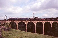
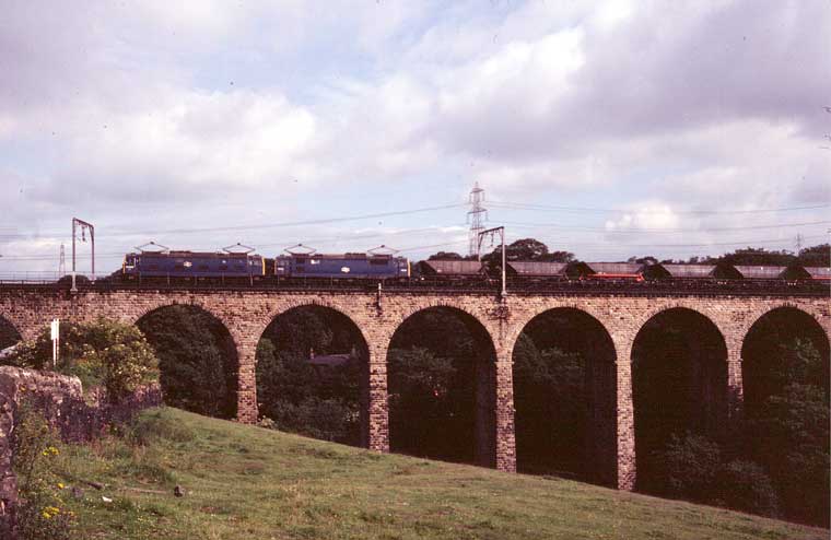
The Oxspring Viaduct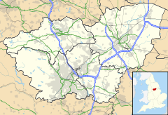
 Oxspring
Oxspring shown within South YorkshirePopulation 1,048 (2001) OS grid reference SE270020 Parish Oxspring Metropolitan borough Barnsley Metropolitan county South Yorkshire Region Yorkshire and the Humber Country England Sovereign state United Kingdom Post town SHEFFIELD Postcode district S36 Dialling code 01226 Police South Yorkshire Fire South Yorkshire Ambulance Yorkshire EU Parliament Yorkshire and the Humber UK Parliament Barnsley West and Penistone Website http://www.oxspring-parish.com List of places: UK • England • Yorkshire Oxspring is a village and civil parish in the Metropolitan Borough of Barnsley in South Yorkshire, England. At the 2001 census it had a population of 1,048.[1]
History
Old maps going back two hundred years or more do not mark a village on the site of present day Oxspring. Instead they mark the hamlet of High Oxspring alongside the top road and they show the position of the former Manor House or Lodge, which until recently was marked on Ordnance Survey maps in the special letters used to indicate an ancient place. The original Oxspring undoubtedly lay across the River Don from the present village.
The earliest historical reference to Oxspring is in the Domesday Book of 1086. The meaning of the name is literally "ox spring". The whereabouts of the original settlement is unknown but the most likely site is that of the former Manor House, which occupied a commanding position on an outcrop of shale above the river. For centuries Oxspring consisted of just a few scattered farms and water driven mills. The Domesday Book also records Rough Birchworth, "the enclosure where birch trees grow". Here was a separate manor and a small farming community with all the buildings clustered together. These two manors together formed the township of Oxspring within the old parish of Penistone. The word "township" has fallen out of use, but in Middle Ages it meant the basic unit of local government.
Little is known about the mediaeval lords who used Oxspring as their surname. In 1547, Godfrey Bosville of Gunthwaite Hall bought the manors of Oxspring, Rough Birchworth and Hornthwaite and almost immediately began to erect the building that was described at the beginning of this century as "The Lodge or Old Manor House", and completed by 1580. In that year Godfrey Bosville's will refers to "the bed and bedsteads at my lodge at Oxspring, and tables and forms there, with all harness, crossbows, rack and artillery". Apparently Bosville used it both as a hunting lodge and as the meeting place of the Oxspring manorial court. As he normally resided at Gunthwaite, the lodge was let to tenant farmers. It became uninhabitable in the late nineteenth century and fell into ruin during the decade before the First World War. Old photographs show that thick stone walls masked a timber-framed building in the post and truss style, which was two and a half storeys high. One room had oak panelling, but elsewhere the timbers were exposed and the gaps between them were filled with well-tempered clay. The staircase wound its way round a newel post with solid oak steps.
The River Don was the source of power to mills in the Middle Ages, and at Oxspring this included the lord's fulling mill or walk mill, where cloth was fulled after it had been woven. In 1306 Robert de Oxspring had granted part of this mill to Henry de Rockley, and further references appear in the records from the sixteenth century onwards. Winterbottom's Wire Works has long occupied the site, but the wooded hillside to the north is still known as Walk Mill Bank. In 1743 John Wood of Oxspring was one of three local fullers who agreed not to full the cloth of any clothier who did not use the new cloth market at Penistone (now Clark's chemist shop), and the township had at least five clothiers in 1806.
In 1818 a private Act of Parliament authorised the enclosure of the 250 or so acres of common land within the township. The Parish Council possesses a copy of the award and map, which were completed eight years later. Before this it had been possible to walk all the way from Oxspring to Thurlstone over common moorland. The work of the enclosure commissioners is still evident in the regular shaped fields and straight roads that characterise the southern part of the parish. A curious feature resulting from this enclosure is the narrow tongue of land that protrudes from Oxspring parish towards Throstle Nest. No doubt this was designed to allow access to the Hartcliff to Green Moor road, which was part of an important mediaeval highway along which salt was brought from Cheshire to Rotherham. Throstle Nest was a prominent boundary point, known as Bleak Royd in old perambulations, where the township of Oxspring met those of Hunshelf and Langsett.
The historical biography Years of Grace by Phylis Crossland describes life in Victorian Oxspring.
References
- Years of Grace: A Biographical Story of Life in a Rural Area of England, 1850-1973, by Phyllis Crossland. Hallamshire Press, 1994. ISBN 1874718458
External links
Categories:- Villages in South Yorkshire
- Geography of Barnsley

Wikimedia Foundation. 2010.