- Lanark County, Ontario
Infobox Settlement
name =
official_name =Lanark County
other_name =
native_name =
nickname = The Maple Syrup Capital of Ontario
settlement_type =County
total_type =
motto =
imagesize =
image_caption =
flag_size =
image_
seal_size =
image_shield =
shield_size =
image_blank_emblem =
blank_emblem_type =
blank_emblem_size =
imagesize =
image_caption =
flag_size =
image_
seal_size =
image_shield =
shield_size =
image_blank_emblem =
blank_emblem_type =
blank_emblem_size =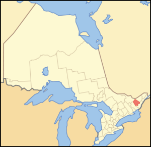
mapsize = 300px
map_caption = Location of Lanark County
mapsize1 =
map_caption1 =
image_dot_
dot_mapsize =
dot_map_caption =
dot_x = |dot_y =
pushpin_
pushpin_label_position =
pushpin_map_caption =
pushpin_mapsize =
subdivision_type = Country
subdivision_name = CAN
subdivision_type1 = Province
subdivision_name1 = ONT
subdivision_type2 =
subdivision_name2 =
seat_type =County seat
seat =Perth
parts_type =Municipalities
parts_style =
parts =Towns & townships
p1 =Beckwith (township)
p2 =Carleton Place (town)
p3=Drummond/North Elmsley (township)
p4=Lanark Highlands (township)
p5=Mississippi Mills (town)
p6=Montague (township)
p7=Perth (town)
p8=Tay Valley (township)
government_footnotes =
government_type =
leader_title =
leader_name =
leader_title1 =
leader_name1 =
established_title =
established_date =
area_magnitude =
unit_pref =Imperial
area_footnotes =cite web |url=http://www12.statcan.ca/english/census06/data/profiles/community/Details/Page.cfm?Lang=E&Geo1=CD&Code1=3509&Geo2=PR&Code2=35&Data=Count&SearchText=Lanark&SearchType=Begins&SearchPR=35&B1=All&Custom= |title=Community highlights for Lanark |accessdate=2007-12-28 |last= |first= |coauthors= |date= |work= |publisher=]
area_total_km2 =
area_land_km2 = 2979.14
area_water_km2 =
area_total_sq_mi =
area_land_sq_mi =1150.25
area_water_sq_mi =
area_water_percent =
elevation_footnotes =
elevation_m =
elevation_ft =
elevation_max_m =
elevation_max_ft =
elevation_min_m =
elevation_min_ft =
population_as_of =2006
population_footnotes =
population_note =
population_total = 63785
population_density_km2 =21.4
population_density_sq_mi =55.5
timezone = EST
utc_offset = -5
timezone_DST = EDT
utc_offset_DST = -4
coor_type =
latd= |latm= |lats= |latNS=
longd= |longm= |longs= |longEW=
postal_code_type =
postal_code =
area_code =
website = [http://www.county.lanark.on.ca/ Lanark County website]
footnotes =Lanark County is a
county located in theCanadian province ofOntario . As of 2001, the population is 62,495. Itscounty seat is Perth.The county took its name from the town of
Lanark inScotland .Geography
According to
Statistics Canada , the county has a total area of convert|1150.25|sqmi|km2|2.Economy
The county is one of the top centres of
maple syrup production in Ontario and describes itself as "The Maple Syrup Capital of Ontario".Demographics
As of the
census GR|2 of 2001, there were 62,495 people, 23,905 households, and 18,090 families residing in the county. Thepopulation density was PD mi2 to km2|54|precision=0|spell=UK. There are 27,781 housing units.There were 23,905 households out of which 32.54% had children living with them, 32.54% were married couples living together, 23.32% are one-person households, and 12.31% are other household types.
In the county, the population was spread out with 19.68% of the population under the age of 15, 11.78% from 15 to 24, 27.39% from 25 to 44, 25.85% from 45 to 64, and 15.28% who were 65 years of age or older. The median age was 40.
The median income for a household in the county was $49,701, and the median income for a family was $56,873. Males have an average income of $45,494 versus $33,525 for females.
Towns and townships
*Almonte (town)
*Beckwith (township)
*Carleton Place (town)
*Drummond/North Elmsley (township)
*Lanark Highlands (township)
*Mississippi Mills (town)
*Montague (township)
*Perth (town)
*Tay Valley (township)While the town of Smiths Falls is physically within the boundaries of the county, it is a separated municipality and is not under the administration of the county government.
Original townships
*Bathurst (Now part of Tay Valley)
*Beckwith (Still exists)
*Dalhousie (Now part of Lanark Highlands)
*Darling (Now part of Lanark Highlands)
*Drummond (Now part of Drummond/North Elmsley)
*Lanark (Now part of Lanark Highlands)
*Lavant (Now part of Lanark Highlands)
*Montague (Still exists)
*North Burgess (Now part of Tay Valley)
*North Elmsley (Now part of Drummond/North Elmsley)
*North Sherbrooke (Now part of Lanark Highlands)
*Pakenham (Now part of the Town of Mississippi Mills)
*Ramsay (Now part of the Town of Mississippi Mills)
*South Sherbrooke (Now part of Tay Valley)References
External links
* [http://www.county.lanark.on.ca/ Lanark County website]
* [http://www.archives.gov.on.ca/english/exhibits/maps/counties/lanark.htm The Changing Shape of Ontario: 1951 map of Lanark county]
* [http://www.communitytransitsolutions.ca Community Transit Solutions]
* [http://groups.yahoo.com/group/declutterizeonlanarkcounty DeClutterize Lanark County Canada]
* [http://www.virtualmuseum.ca/pm.php?id=exhibit_home&fl=0&lg=English&ex=00000091 The Joy of Effort - A History of Physical Activity]
Wikimedia Foundation. 2010.