- North Shore (Sydney)
-
North Shore
New South Wales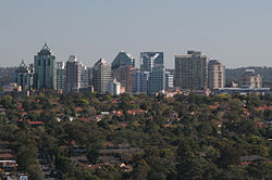
ChatswoodPopulation: 207,241 (2007) [1] LGA:  North
North
ShoreThe North Shore is an informal term used to describe the primarily residential area of northern metropolitan Sydney, in the state of New South Wales, Australia. The term usually refers to the suburbs located on the north shore of Sydney Harbour between Middle Harbour and the Lane Cove River, up to the northern border of the Ku-ring-gai local government area. Since it is not clearly defined, it has been incorrectly used to refer to suburbs further west to the Ryde Bridge, although this wider description encompasses what is also known as the Northern Suburbs.
Contents
History
Before British settlement, the Lower North Shore was home to the Gorualgal (Mosman and southern Willoughby) and Cammeraygal (North Sydney and Eastern Lane Cove).
After the establishment of Sydney in 1788, settlement of the North Shore of the harbour was quite limited. One of the first settlers was James Milson (1785-1872) who lived in the vicinity of Jeffrey Street in Kirribilli, directly opposite Sydney Cove. The north shore was more rugged than the southern shore and western areas of the harbour and had limited agricultural potential. The early activities in the area included tree felling, boatbuilding and some orchard farming in the limited areas of good soil. The North Shore Line was built in the 1890s. Access to the Sydney CBD, located on the southern shore of the harbour remained difficult until the completion of the Sydney Harbour Bridge in 1932. This led to commencement the development of suburbs on the North Shore.
Cumberland County mapping from 1792 to 1894 indicate that the four local governments that stand today were derived from 1[citation needed]: the Parish of Willoughby. From the Parish of Willoughby came the City of Willoughby and the municipalities of Mosman, Lane Cove and North Sydney. North Sydney was formerly known as St. Leonards.
Geography
 The suburb of Chatswood lies in the centre of the North Shore
 Lavender Bay Wharf
 Tunks Park, Cammeray
Most of the North Shore suburbs are part of the Hawkesbury Plateau, a large sandstone plateau overlaid by a system of ridges and gullies. The Plateau begins north of the Port Jackson and runs up until the Hawkesbury River. Thus much of the North Shore is hilly with many steep valleys running down into the harbour and the rivers on either side. These ridges and valleys were originally populated with dry sclerophyll forest, much of which still remains. There are many small parks and areas of the sclerophyll forest adjacent to and within residential areas, earning the area the nickname "the leafy North Shore". The Lane Cove National Park and the Garigal National Park include many areas of remnant bushland adjacent to the Lane Cove River and Middle Harbour. There is excellent bushwalking, abseiling and bouldering around Lindfield and North Turramurra. Gordon houses one of Sydney's largest bat colonies in a Bat reserve leading to Middle Harbour.
Upper North Shore
The "Upper North Shore" usually refers to the suburbs north of Chatswood, east of the Lane cove river and south of the uppermost border of the Ku-ring-gai council area. It is made up of the handful of suburbs encompassing the Ku-ring-gai council. The area is known for its clean leafy streets, stately homes and high property prices. Ku-ring-gai was rated as having the number 1 quality of life in Australia (there are 590 Australian Local Government Areas) in the BankWest Quality of Life Index 2008.
Lower North Shore
The Lower North Shore encompasses all of the North Shore's northern shore of Sydney Harbour stretching from the Lane cove River in the west to Middle Head (Mosman) in the east and includes Mosman, Kirribilli and Longueville.
The Lower North Shore usually refers to the suburbs adjacent to the harbour such as Neutral Bay, Waverton, Mosman, Cremorne, Lavender Bay, Milsons Point, Cammeray and North Sydney. The Lower North Shore has an eastern boundary adjacent to Middle Harbour, or at the Roseville Bridge at Castle Cove and Roseville Chase. The term Lower North Shore can include the local government areas of Municipality of Mosman, City of Willoughby, Municipality of Lane Cove and North Sydney Council.
The region is home to hundreds of parks and reserves, including Sydney Harbour National Park and the Lane Cove National Park. Local sportsgrounds include North Sydney Oval, the region's largest in capacity, followed by Chatswood Oval and Christie Park. Major waterways in the region include Port Jackson, the Lane Cove River, the Parramatta River, Middle Harbour and the many creek systems that branch out from these main aquatic lifelines.
Transport
The main transport routes on the North Shore are Military Road, the Pacific Highway and the Warringah Expressway, and the North Shore Line and the Northern Line, which provide access to the central business district of Sydney over the Sydney Harbour Bridge. Many bus routes also serve the area, particularly the lower North Shore, and ferries connect many of the harbourside suburbs with Circular Quay in the central business district.
Commercial areas
 The Forum, St Leonards
 North Sydney from the air
Significant commercial and retail centres on the North Shore include North Sydney, Crows Nest, Chatswood, St Leonards, Neutral Bay and Gordon.
The North Shore has two large commercial centres located at North Sydney and Chatswood with many international companies have their Australian or Asia Pacific Headquarters in this part of Sydney. The region's largest central business district at North Sydney, is home to a modern urban skyline of skyscrapers. Although North Sydney has none of Sydney's major shopping centres, it is home to scores of speciality stores and cafés. Chatswood is one of the largest retail areas. It is home to large shopping centres such as Westfield Chatswood, Chatswood Chase and apartment towers such as The Sebel. St Leonards is another large commercial area featuring mostly office space and apartments.
Landmarks
 Taronga Zoo
The Lower North Shore has many unique landmarks such as: The Sydney Harbour Bridge, Taronga Zoo in Mosman, Kirribilli House (Sydney residence of the Prime Minister of Australia), Luna Park and Balmoral Beach. At a Sydney or local level however, landmarks are more plentiful and include: The Lane Cove Azalea Beds, Blues Point Tower, Eden Gardens, the Balmoral Rotunda, the Stanton Library in North Sydney, Lane Cove Plaza, Zenith Towers at Chatswood, Northpoint Tower in North Sydney, Cammeray suspension bridge at Cammeray, Echo Point Park in Roseville Chase, the Royal North Shore Hospital, the Hornsby Water Clock, the 'Forum' in St Leonards and North Sydney Oval.
Landmark churches in the area include St Mary's in North Sydney, Christ Church in Lavender Bay, the Gladesville-Macquarie Chapel and St Paul's in Chatswood.
Events and celebrations
The Willoughby Spring Festival is held throughout the Willoughby local government area, in September each year. The festival lasts for a month and features over 40 events including live music/entertainment, exhibitions, cultural celebrations, business events and many more community activities. The highlight is the annual Willoughby StreetFair where the Chatswood CBD is taken over by market stalls, performers, dancers and musicians. The StreetFair features the Willoughby Street Parade which included over 1,000 participants in 2007.
The Lower North Shore's other main festivals/events include: Tartan Day at Lane Cove, the Guringgai Festival honouring northern Sydney's Aboriginals, the Moocooboola Festival at Hunters Hill, the Mosman Festival, Lane Cove's Cammeraygal Festival, Chinese New Year at Chatswood. Mosman, North Sydney, Willoughby also holds an annual art prize. All local government areas in the region and around the country celebrate Australia Day, which is the 26th of January.
Organisations
The local newspapers are the 'Hornsby Advocate', 'The North Shore Times', 'The Mosman Daily' and the North Shores' local lifestyle publication 'NORTHSIDE'.
Climate
North Shore, Sydney has a temperate climate. Turramurra is the wettest place not just in the North Shore, but the whole of Sydney, with an average of 1724mm of rainfall per year.
Climate data for North Shore, Sydney Month Jan Feb Mar Apr May Jun Jul Aug Sep Oct Nov Dec Year Record high °C (°F) 44
(111)42
(108)39
(102)33
(91)29
(84)25
(77)24
(75)29
(84)33
(91)38
(100)41
(106)41
(106)44
(111)Average high °C (°F) 28
(82)27
(81)26
(79)23
(73)20
(68)15
(59)15
(59)16
(61)19
(66)23
(73)25
(77)27
(81)22 Average low °C (°F) 21
(70)20
(68)17
(63)14
(57)9
(48)8
(46)7
(45)8
(46)10
(50)14
(57)17
(63)20
(68)13 Record low °C (°F) 10
(50)9
(48)8
(46)7
(45)3
(37)-0
(32)−1
(30)0
(32)4
(39)5
(41)7
(45)9
(48)−1
(30)Precipitation mm (inches) 147
(5.79)208
(8.19)160
(6.3)134
(5.28)102
(4.02)88
(3.46)54
(2.13)39
(1.54)22
(0.87)37
(1.46)57
(2.24)112
(4.41)1,160
(45.67)% humidity 77 81 79 74 68 62 54 63 68 71 72 74 68 Avg. precipitation days 15 19 17 14 12 10 7 4 3 4 7 13 125 Sunshine hours 220 188 198 192 183 165 198 220 216 223 234 226 2,482 Source: Bureau of Meteorology[2] List of suburbs
Upper North Shore
Lower North Shore
- Northbridge
- Northwood
- Riverview
- St Leonards
- Waverton
- Willoughby
- Willoughby North
- Wollstonecraft
- Woolwich
Localities
- Clifton Gardens
- Cremorne Junction
- Georges Heights
- Gore Hill
- Osborne Park
- Spit Junction
- The Spit
References
- ^ http://www.colliersresidential.com/files//research/sydneys_upper_and_lower_north_shore_pw_nov_08.pdf
- ^ "Sydney (Observatory Hill)". Climate statistics for Australian locations. Bureau of Meteorology. http://www.bom.gov.au/climate/averages/tables/cw_066062.shtml. Retrieved 11 December 2009.
Regions of Sydney Local Government Areas of SydneyAshfield · Auburn · Bankstown · Blacktown · Botany Bay · Burwood · Camden · Campbelltown · Canada Bay · Canterbury · Fairfield · The Hills · Holroyd · Hornsby · Hunter's Hill · Hurstville · Kogarah · Ku-ring-gai · Lane Cove · Leichhardt · Liverpool · Manly · Marrickville · Mosman · North Sydney · Parramatta · Penrith · Pittwater · Randwick · Rockdale · Ryde · Strathfield · Sutherland · City of Sydney · Warringah · Waverley · Willoughby · WoollahraCategories:


Wikimedia Foundation. 2010.