- Cockley Cley
-
Coordinates: 52°36′24″N 0°38′44″E / 52.60673°N 0.64554°E
Cockley Cley 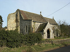
Cockley Cley All Saints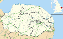
 Cockley Cley
Cockley Cley shown within NorfolkArea 17.94 km2 (6.93 sq mi) Population 138 - Density 8 /km2 (21 /sq mi) OS grid reference TF792042 Parish Cockley Cley District Breckland Shire county Norfolk Region East Country England Sovereign state United Kingdom Post town SWAFFHAM Postcode district PE37 Police Norfolk Fire Norfolk Ambulance East of England EU Parliament East of England List of places: UK • England • Norfolk Cockley Cley is a village and civil parish in the English county of Norfolk. It covers an area of 17.94 km2 (6.93 sq mi) and had a population of 138 in 58 households as of the 2001 census.[1] For the purposes of local government, it falls within the district of Breckland.
Its church, All Saints, is one of 124 existing round-tower churches in Norfolk. It was restored in 1866-1888 by diocesan architect Richard Phipson.[2] In 1991 part of the tower collapsed. The interior was not harmed and still exhibits the Victorian idea of how a church should look. The north arcade is 14th century, and it has been copied for the south arcade.[3]
References
- ^ Census population and household counts for unparished urban areas and all parishes. Office for National Statistics & Norfolk County Council (2001). Retrieved 20 June 2009.
- ^ Wilson, Bill (2002). Norfolk, Part 2. Yale UP. p. 265. ISBN 9780300096576. http://books.google.com/books?id=qsqx_SK3bzUC&pg=PA265.
- ^ The Round Tower Churches of Norfolk by Lyn Stilgoe and Dorothy Shreeve, Canterbury Press, Norwich; ISBN 1-85311-448-0
External links
Categories:- Breckland
- Villages in Norfolk
- Civil parishes in Norfolk
- Norfolk geography stubs


Wikimedia Foundation. 2010.