- Oropedio Lasithiou
-
Oropedio Lasithiou
Οροπέδιο Λασιθίου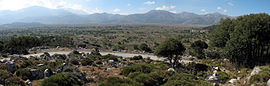
Panorama of the Lasithi PlateauLocation 
 Oropedio Lasithiou
Coordinates 35°11′N 25°28′E / 35.183°N 25.467°ECoordinates: 35°11′N 25°28′E / 35.183°N 25.467°E Location within the region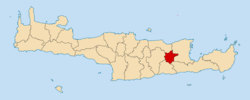
Government Country: Greece Region: Crete Regional unit: Lasithi Population statistics (as of 2001) Municipality - Population: 3,152 - Area: 130.0 km2 (50 sq mi) - Density: 24 /km2 (63 /sq mi) Other Time zone: EET/EEST (UTC+2/3) Auto: AN Oropedio Lasithiou or Lasithi Plateau (Greek: Οροπέδιο Λασιθίου) is a large scenic plain, and a municipality, located in the Lasithi peripheral unit in eastern Crete, Greece. The seat of the municipality is the village Tzermiado.[1]
Contents
Geography
The Lasithi Plateau stretches (11 km (6.8 mi) in the E-W direction and 6 km (3.7 mi) in the N-S direction. It is approximately 70 km (43 mi) east from Heraklion and lies at an average altitude of 840 m (2,760 ft), which makes it one of the few permanently inhabited areas of such altitude around the Mediterranean. Winters are often very harsh and snow on the plain and surrounding mountains can persist until mid-spring. Lasithi plateau is famous for its white-sailed windmills that have been used for decades to irrigate the land. Despite their vast number (some 10,000) in the past, most of them have been abandoned nowadays in favour of modern diesel and electrical pumps.
History
The fertile soil of the plateau, due to alluvial run-off from melting snow, has attracted inhabitants since Neolithic times (6000 BC). Minoans and Dorians followed and the plateau has been continuously inhabited since then, except a period that started in 1293 and lasted for over two centuries during the Venetian occupation of Crete. During that time and due to frequent rebellions and strong resistance, villages were demolished, cultivation prohibited, and natives were forced to leave and forbidden to return under a penalty of death. A Venetian manuscript of the thirteenth century describes the troublesome plateau of Lasithi as spina nel cuore (di Venezia) - a thorn in the heart of Venice. Later, in the early 15th century, Venetian rulers allowed refugees from the Greek mainland (eastern Peloponnese) to settle in the plain and cultivate the land again. To ensure good crops, Venetians ordered the construction of a large system of drain ditches (linies, Greek: λίνιες) that are still in use. The ditches transfer the water to Honos (Greek: Χώνος), a sinkhole in the west edge of the plateau.
During the Greek War of Independence in January 1823, Hassan Pasha led an army of Ottoman and Egyptian forces sent by Muhammad Ali that seized the plateau killing most residents who had not fled to the mountains. In May 1867 during the great Cretan revolt, Ottoman and Egyptian forces under the command of Pashas Omar and Ismail Selim marched towards the Lasithi plateau. Their aim was to strike a decisive blow on the revolutionaries who used it as their hideout. After fierce fighting, the outnumbered rebels were defeated and forced to retreat to the slopes of Dikti. Between 21 and 29 of May, many village dwellers were slaughtered or taken slaves, their homes were set ablaze after being looted and livestock and crops were destroyed.[2] The monastery of Kroustalenia that was the seat of the revolutionary committee was also destroyed.
Archaeological sites
There are several caves of archaeological interest in the surrounding countryside, of which Diktaion Andron (Greek: Δικταίον Άντρον, also Diktaean / Diktaian Cave) near the village of Psychro (Greek: Ψυχρό) is the birthplace of Zeus according to Greek Mythology. Zeus is also said to have used Diktaion Andron as his hiding place after abducting Europa.
Economy
Permanent residents derive most of their income from agriculture and animal farming. A small fraction of the population is also occupied in tourism.
Gallery
-

Lasithi Plateau in white.
-

The symbol of the plateau, an irrigation windmill.
-

Ruins of abandoned windmills once used to grind cereals in Ampelos saddle.
-

Lasithi Plateau municipal seal.
See also
External links
References
- ^ Kallikratis law Greece Ministry of Interior (Greek)
- ^ Γ. Παναγιωτάκης: Οι μάχες του Οροπεδίου Λασιθίου, Πατρίς onLine, 2 Ιουνίου 2006
Administrative division of the Crete Region Area: 8,336km² • Population : 601,131 (2001) • Capital: Heraklion Regional unit of Chania Regional unit of HeraklionArchanes–Asterousia • Faistos • Gortyna • Heraklion • Hersonissos • Malevizi • Minoa Pediada • ViannosRegional unit of LasithiAgios Nikolaos • Ierapetra • Oropedio Lasithiou • SiteiaRegional unit of Rethymno
Regional governor: Stavros Arnaoutakis • Website www.pkr.gov.gr -