- Cape Breton Island
Infobox Islands
name = Cape Breton
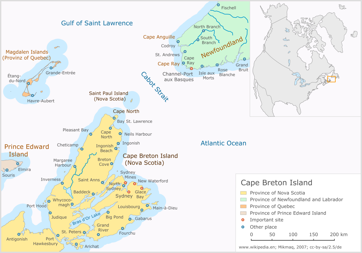
image caption = Cape Breton Island, Nova Scotia, Canada
image size =
locator
Location map|Canada Nova Scotia|lat=46.166667|long=-60.75|marksize=16
map_custom = yes
native name =
native name link =
nickname =
location =Atlantic Ocean
coordinates = coord|46|10|N|60|45|W|display=inline
archipelago =
total islands =
major islands =
area = convert|10311|km2|sqmi|abbr=on
rank = 77th
length =
width =
highest mount = White Hill
elevation = convert|532|m|ft|abbr=on
country = Canada
country admin divisions title = Province
country admin divisions = flag|Nova Scotia
country admin divisions title 1 =
country admin divisions 1 =
country admin divisions title 2 =
country admin divisions 2 =
country largest city =
country largest city population =
population = 147,454
population as of = 2001
density = 14.30
ethnic groups =
additional info =Cape Breton Island (French: "île du Cap-Breton" - formerly "île Royale",
Scottish Gaelic : "Eilean Cheap Breatuinn", Míkmaq: "Únamakika", simply: "Cape Breton") is anisland on the Atlantic coast ofNorth America . It likely corresponds to the French word "Breton", referring toBrittany .Cape Breton Island is part of the province of
Nova Scotia ,Canada . Although physically separated from theNova Scotia peninsula by theStrait of Canso , it is artificially connected to mainland Nova Scotia by theCanso Causeway . The island is located east-northeast of the mainland with its northern and westerncoast s fronting on theGulf of St. Lawrence ; its western coast also forming the eastern limits of theNorthumberland Strait . The eastern and southern coasts front the Atlantic Ocean; its eastern coast also forming the western limits of theCabot Strait . Its landmass slopes upward from south to north, culminating in the highlands of its northern cape. A saltwater estuary,Bras d'Or Lake , dominates the centre of the island.The island is divided into four of Nova Scotia's eighteen counties: Cape Breton, Inverness, Richmond, and Victoria. Their total population as of the 2001 census numbered 147,454 "Cape Bretoners"; this is approximately 16% of the provincial population. Cape Breton Island has experienced a decline in population of approximately 6.8% since the previous census in 1996. Approximately 72% of the island's population is located in the Cape Breton Regional Municipality (CBRM) which includes all of Cape Breton County and is often referred to as
Industrial Cape Breton , given the history ofcoal mining and steel manufacturing in this area.The island contains five reserves of the Mi'kmaq Nation, these being: Eskasoni, Membertou, Wagmatcook,
We'kopaq/Waycobah , andPotlotek/Chapel Island . Eskasoni is the largest in both population and land area.History
Cape Breton Island's first residents were likely Maritime Archaic Indians, ancestors of the
Mi'kmaq Nation, the later of whom inhabited the island at the time of European discovery. Giovanni Caboto (John Cabot) reportedly visited the island in 1497 to become the first Renaissance European explorer to visit present-day Canada. However, historians are unclear as to whether Cabot first visited Newfoundland or Cape Breton Island. This discovery is commemorated by Cape Breton'sCabot Trail .A fishing colony was established on the island about 1521–22 by the Portuguese under
João Alvares Fagundes . As many as 200 settlers lived in the nameless village in what is now present day Ingonish (location according to some historians) on the island's northwestern peninsula. The fate of the colony is unknown, but it is mentioned as late as 1570. ["Francisco de Souza"; Tratado das Ilhas Novas, 1570 ]On
February 8 ,1631 , Charles I granted Cape Breton Island to Robert Gordon ofLochinvar and his son Robert.The island saw active settlement by
France with the island being included in the colony ofAcadia . A Frenchgarrison was established in the central eastern part at Ste-Anne in the early 18th century, before relocating to a much larger fortification at Louisbourg to improve defences at the entrance to theGulf of St. Lawrence and defend France's fishing fleet on theGrand Banks . They also built theLouisbourg Lighthouse in 1734, the first lighthouse in Canada and one of the first in North America. The French named the island "Île Royale". It remained part of colonial France until it was ceded to Britain under the Treaty of Paris in 1763. Britain merged the island with its adjacent colony of Nova Scotia (present day peninsular Nova Scotia andNew Brunswick ).Some of the first British-sanctioned settlers to the island following the
Seven Years' War were Irish, although upon settlement, they merged with local French communities to form a culture rich in both music and tradition. From 1763 to 1784 the island was administratively part of the colony ofNova Scotia and governed from Halifax.The first permanently settled Scottish community on Cape Breton Island was
Judique , settled in 1775 by Michael Mor MacDonald. He spent his first winter using his upside-down boat for shelter, which is reflected in the architecture of the village's Community Centre. He composed a song about the area called "O's alainn an t-aite", or "Fair is the Place."In 1784, Britain split the colony of Nova Scotia into three separate colonies: New Brunswick, Cape Breton Island, and present-day peninsular Nova Scotia, in addition to the adjacent colonies of St. John's Island (renamed Prince Edward Island in 1798) and Newfoundland. The colony of Cape Breton Island had its capital at Sydney on its namesake harbour fronting on Spanish Bay and the
Cabot Strait . Its first Lieutenant-Governor wasJoseph Frederick Wallet DesBarres (1784–1787) and his successor wasWilliam Macarmick (1787). From 1799 to 1807 the military commandant was John Despard, brother of Edward. ["John Despard"; The Companion to British History, Routledge ]An order forbidding the granting of land in Cape Breton, issued in 1763, was removed in 1784. The mineral rights to the island were given over to the Crown by an order-in-council. The British government had intended that the Crown take over the operation of the mines when Cape Breton was made a colony, but this was never done, probably because of the rehabilitation cost of the mines. The mines were in a neglected state, caused by careless operations dating back at least to the time of the final fall of Louisbourg.
In 1820, the colony of Cape Breton Island was merged for the second time with Nova Scotia, this being present-day peninsular Nova Scotia. This development is one of the factors which led to large-scale industrial development in the Sydney Coal Field of eastern Cape Breton County (see
Industrial Cape Breton ). By the late 19th century, as a result of the faster shipping, expanding fishery and industrialization of the island, exchanges of people between the island of Newfoundland and Cape Breton increased beginning a cultural exchange that continues to this day.During the first half of the 19th century, Cape Breton Island experienced an influx of
Highland Scots numbering approximately 50,000 as a result of theHighland Clearances . Today, the descendants of the Highland Scots dominate Cape Breton Island's culture, particularly in rural communities. To this day Gaelic is still the first language of a number of elderly Cape Bretoners. A campaign by the provincial government during the 19th and early 20th centuries aimed to eradicate the use of Gaelic among school children. The growing influence of English-dominated media from outside the Scottish communities saw the use of this language erode quickly during the 20th century. Many of the Scots who immigrated there were either Roman Catholics or Presbyterians.Tourism promotions beginning in the 1950s recognized the importance of the Scottish culture to the province, and the provincial government started encouraging the use of Gaelic once again. The establishment of funding for the
Gaelic College of Celtic Arts and Crafts and formal Gaelic languageinstruction in public schools are intended to address the near-loss of this culture to English assimilation.The turn of the 20th century saw Cape Breton Island at the forefront of scientific achievement with the now-famous activities launched by inventors
Alexander Graham Bell andGuglielmo Marconi .Following his successful invention of the
telephone and being relatively wealthy, Bell acquired land near Baddeck in 1885, largely due to surroundings reminiscent of his early years inScotland . He established a summer estate complete with research laboratories, working with deaf people - includingHelen Keller - and continued to invent. Baddeck would be the site of his experiments withhydrofoil technologies as well as theAerial Experiment Association , financed by his wife, which saw the first powered flight in theBritish Empire when the AEA "Silver Dart" took off from the ice-covered waters ofBras d'Or Lake . Bell also built the forerunner to theiron lung and he experimented with breeding sheep.Marconi's contributions to Cape Breton Island were somewhat less than Bell's as he merely used the island's geography to his advantage in transmitting the first trans-Atlantic
radio message from a station constructed at Table Head in Glace Bay to a receiving station atPoldhu inCornwall ,England .Geography
The island measures 10,311 square kilometres in area (3,981 sq mi), making it the 75th largest island in the world and Canada's 18th largest island. Cape Breton Island is composed mainly of rocky
shore s, rollingfarm land, glacialvalley s, barren headlands,mountain s, woods andplateau s. Geological evidence suggests that at least part of the island was originally joined with present-dayScotland andNorway , now separated by millions of years ofcontinental drift .The northern portion of Cape Breton Island is dominated by the
Cape Breton Highlands , commonly shortened to simply the "Highlands", which are an extension of the Appalachian mountain chain. The Highlands comprise the northern portions of Inverness and Victoria counties. In 1936 the federal government established theCape Breton Highlands National Park covering convert|949|km2|sqmi|abbr=on across the northern third of the Highlands. TheCabot Trail scenic highway also encircles the coastal perimeter of the plateau.Cape Breton Island's hydrological features include the
Bras d'Or Lake system, a salt-waterfjord at the heart of the island, andfreshwater features includingLake Ainslie , theMargaree River system, and the Mira River. Innumerable smallerriver s andstream s drain into the Bras d'Or Lakeestuary and onto the Gulf of St. Lawrence and Atlantic coasts.Cape Breton Island is now joined to the mainland by the
Canso Causeway , completed in 1955, enabling directroad and railtraffic to and from the island, but requiringmarine traffic to pass through theCanso Canal at the eastern end of thecauseway .Cape Breton Island is divided into four counties: Cape Breton, Inverness, Richmond, and Victoria.
Demographics
The island's residents can be grouped into five main cultures; Scottish,
Mi'kmaq ,Acadian , Irish, and English, with respective languages Gaelic, Mi'kmaq, French, and English. English is now the primary spoken language, though Mi'kmaq, Gaelic and French are still heard.Later migrations of
Black Loyalists ,Italians , andEastern European s mostly settled in the eastern part of the island around the Industrial Cape Breton region. The population of Cape Breton Island has been in decline for almost two decades with an increasing population exodus in recent years due to economic conditions.According to the Census of Canada, the population of Cape Breton Island in 2001 was 147,454, a 6.8% decline from 158,260 in 1996.
Racial/Ethnic composition
*95.0% Caucasian
*3.6%Mi'kmaq (Canadian First Nation)
*0.7% Black
*0.1%Arab Religious groups
[http://www.statcan.ca/ Statistics Canada] in 2001 reported a "religion" total of 107,880 for Cape Breton, including 3,915 with "no religious affiliation." [ [http://www12.statcan.ca/english/census01/products/standard/themes/RetrieveProductTable.cfm?Temporal=2001&PID=55822&METH=1&APATH=3&PTYPE=55440&THEME=56&FREE=0&AID=0&FOCUS=0&VID=0&GC=0&GK=0&SC=1&CPP=99&SR=1&RL=0&RPP=9999&D1=0&D2=0&D3=0&D4=0&D5=0&D6=0&GID=431530 Table from Statistics Canada] ] Major categories included:
* Roman Catholic: 69,820
* Protestant: 32,575 (including 13,790 United Church and 10,170 Anglican)
* Orthodox: 395
* Jewish: 235
* Muslim: 135Synagogues in Sydney and Glace Bay serve a small historic Jewish community (which was once one of the larger ones in eastern Canada) while more recent Muslim immigrants hold Friday prayers at
Cape Breton University . Buddhists are a tiny minority (70 in 2001, according to Statistics Canada), althoughGampo Abbey in Pleasant Bay has been operational since 1984.Economy
Cape Breton Island has two major coal deposits: the Sydney Coal Field in the southeastern part of the island along the Atlantic Ocean drove the Industrial Cape Breton economy throughout the 19th and 20th centuries - until after
World War II its industries were the largest private employers in Canada; the Inverness Coal Field in the western part of the island along the Gulf of St. Lawrence is significantly smaller but hosted several mines.Sydney has traditionally been the main port, with various facilities in a large, sheltered, natural harbour. It is the Island's largest commercial center and home to the Island's daily newspaper, the
Cape Breton Post , as well as its only active television studio,CJCB-TV , and several radio stations. TheMarine Atlantic terminal at North Sydney is the terminal for large ferries travelling to Channel–Port aux Basques and seasonally to Argentia on the island of Newfoundland.Point Edward on the west side of Sydney Harbour is the location of Sydport, a former navy base (warship|HMCS|Protector) now converted to commercial use. The
Canadian Coast Guard College is located nearby at Westmount. Petroleum, bulk coal, and cruise ship facilities are also located in Sydney Harbour.Glace Bay is the second largest urban community in population and was the island's main coal mining centre until its last mine ceased operation in the 1980s. Glace Bay served as the hub of the Sydney & Louisburg Railway and also as a major fishing port. At one time, Glace Bay was known as the largest town in Nova Scotia, based on population.Port Hawkesbury has risen to prominence since the completion of the Canso Causeway and
Canso Canal created an artificial deep-water port, allowing extensive petrochemical, pulp and paper, and gypsum handling facilities to be established. The Strait of Canso is completely navigable to seaway-max vessels, and Port Hawkesbury is open to the deepest-draught vessels on the world's oceans. Large marine vessels may also enter Bras d'Or Lake through the Great Bras d'Or channel whereas small craft have the additional use of the Little Bras d'Or channel orSt. Peters Canal . TheSt. Peters Canal is no longer used by commercial shipping on Cape Breton Island but is an important waterway for recreational vessels.The industrial Cape Breton area faced several challenges with the closure of the
Cape Breton Development Corporation 's (DEVCO)coal mine s and theSydney Steel Corporation 's (SYSCO)steel mill . In recent years the Island's residents have been attempting to diversify the area economy by investing in tourism developments,call centre s, and small businesses, as well as manufacturing ventures in such fields as auto parts, pharmaceuticals, and window glazings.While the Cape Breton Regional Municipality is in transition from an industrial to a service-based economy, the rest of Cape Breton Island outside of the industrial area surrounding Sydney-Glace Bay has been more stable, with a mixture of fishing, forestry, small-scale agriculture, and tourism.
Tourism in particular has grown throughout the post-Second World War era, especially the growth in vehicle-based touring, which was furthered by the creation of the
Cabot Trail scenic drive. The scenery of the island is rivalled in northeastern North America only by Newfoundland and Cape Breton Island tourism marketing places a heavy emphasis on its Scottish Gaelic heritage through events such as the Celtic Colours Festival, held each October, as well as promotions through theGaelic College of Celtic Arts and Crafts .A popular attraction for tourists isn't on the land, but in the water - whales. Whale-watching cruises are operated by numerous vendors from Baddeck to Cheticamp. The most popular species of whale found in Cape Breton's waters is the Pilot whale.
The primary east-west road on the island is Highway 105, the
Trans-Canada Highway , although Trunk 4 is also heavily used. Highway 125 is an important arterial route around Sydney Harbour in theCape Breton Regional Municipality . TheCabot Trail , circling the Cape Breton Highlands, and Trunk 19, along the western coast of the island, are important secondary roads. Railway connections between the port of Sydney toCanadian National Railway in Truro are maintained by theCape Breton and Central Nova Scotia Railway .The
Cabot Trail is a scenic road circuit around and over theCape Breton Highlands with spectacular coastal vistas; over 400,000 visitors drive the Cabot Trail each summer and fall. Coupled withFortress Louisbourg , it has driven the growth of the tourism industry on the island in recent decades. The "Condé Nast" travel guide has rated Cape Breton Island as one of the best island destinations in the world.Traditional music
Cape Breton is well known for its traditional fiddle music, which was brought to North America by Scottish
immigrants during theHighland Clearances . The traditional style has been well preserved in Cape Breton, andceilidh s have become a popular attraction for summer tourists. Inverness County in particular has a heavy concentration of musical activity, with regular performances in communities such as Mabou and Judique. Judique is recognized as 'Bhaile nam Fonn', (literally: Village of Tunes) or the 'Home of Celtic Music', featuring the Celtic Music Interpretive Centre. Performers who have received significant recognition outside of Cape Breton includeBuddy MacMaster ,Natalie MacMaster ,Ashley MacIsaac ,The Rankin Family ,Aselin Debison , andThe Barra MacNeils .The Men of the Deeps are a male choral group of current and former miners from the industrial Cape Breton area.Film and television
*"" starring
Adam Beach
*"Johnny Belinda " byElmer Blaney Harris .
*"Margaret's Museum " starringHelena Bonham Carter .
*"The Bay Boy " starringKiefer Sutherland .
*"New Waterford Girl "
*"The Hanging Garden "
*"Marion Bridge"
*"My Bloody Valentine"
*"Pit Pony", TV movie and series adapted from the novel by Joyce BarkhouseNotable people
The Arts
*
Don Domanski , Canada's premier poet
*Nathan Bishop , singer-songwriter fromCeltae
*John Allan Cameron , singer-songwriter, from Glencoe Station, credited as the "Godfather" of Cape Breton's modern Celtic music revival
*Joe Cormier , fiddle player, organizer of Cape Breton Symphony, Cheticamp. http://www.rounder.com/series/nat/cormier1.html, http://www.sheldonbrown.org/revels/cormier.html
*J.P. Cormier , singer-songwriter, fiddle, mandolin, banjo guitar-player, Cheticamp.
*Lesley Crewe , Author of "Relative Happiness" and "Shoot Me"
* Mark Day, film & television actor, writer, and producer from Port Hawkesbury
*Aselin Debison , singer-songwriter
* Winston "Scotty" Fitzgerald, fiddle player from White Point, Victoria County, Nova Scotia
*Danny Gallivan ,Hockey Night in Canada sportscaster
*Bruce Guthro , singer-songwriter
*Mary Jane Lamond , Gaelic singer
*Angus MacAskill , giant and circus performer
*Ashley MacIsaac , fiddle player from Creignish
*Slowcoaster , jam rock band
*Daniel MacIvor , actor, playwright, theatre director and film director from Sydney
*Hugh MacLennan ,Governor General's Awards winning Author "Barometer Rising ", and "Two Solitudes ".
*Alistair MacLeod , author
*Steve Arbuckle , actor
* TheBarra MacNeils , singing group
*Rita MacNeil , singer-songwriter, from Big Pond
*Buddy MacMaster , fiddle player from Judique
*Natalie MacMaster , fiddle player from Troy
* [http://www.duncanwells.ca Duncan Wells] , singer-songwriter
*Daniel Petrie , Hollywood filmmaker
*The Rankin Family , singers-songwriters, from Mabou
*Rick Ravanello , actor,Hart's War , various TV series including 24, andDesperate Housewives
*Harold Russell , Academy Award winning actor for his portrayal of Homer Parrish, in the 1946 film "The Best Years of Our Lives ".
*Gordie Sampson , singer-songwriter from Big PondAthletes
*
Al MacInnis
*Mike McPhee
*Aaron Johnson
*Johnny Miles
* Bobby SmithPolitics and business
*
John Buchanan ,Premier of Nova Scotia
*Mayann Francis , First Black Lieutenant Governor ofNova Scotia
* Angus L. MacDonald,Premier of Nova Scotia
*Rodney MacDonald ,Premier of Nova Scotia
*Allan MacEachen , Former Deputy Prime Minister / Finance Minister
*Russell MacLellan ,Premier of Nova Scotia
*Elizabeth May , Leader of theGreen Party of Canada
*John W. Morgan , Mayor of Cape Breton Regional Municipality
*Irving Schwartz , Businessman, Philanthropist, member of theOrder of Canada Religion
*
Moses E. Kiley ,Roman Catholic archbishop of theRoman Catholic Archdiocese of Milwaukee ,Milwaukee, Wisconsin See also
*
Canadian Gaelic
*Cape Breton accent
*Cape Breton Labour Party
*Cape Breton Regional Municipality, Nova Scotia
*Provinces and territories of Canada
*Province of Cape Breton
*Cape Breton References
* [http://www12.statcan.ca/english/census01/products/standard/popdwell/Table-CD-D.cfm?T=2&SR=1&S=1&O=A&PR=12 Counties of Nova Scotia; Statistics Canada]
* [http://atlas.nrcan.gc.ca/site/english/learningresources/facts/islands.html Sea islands: Natural Resources Canada Atlas of Canada]
* [http://www12.statcan.ca/english/census01/products/standard/popdwell/Table-CD-M.cfm?T=2&PR=12&CD=1217&SR=1 Cape Breton County and its divisions, Nova Scotia; Statistics Canada]External links
* [http://cbwireless.ednet.ns.ca/index.html Cape Breton Wireless Heritage Society]
* [http://www.provinceofcapebreton.com/ Movement for a Free and Independent Province of Cape Breton]
* [http://www.duncanwells.ca/4men.htm Cape Breton Island's 4 Men In A Tub]
* [http://www.cape-breton.com Cape Breton Island Directory]
* [http://irishcaper.ca Caper Canada]
* [http://www.fotw.net/flags/ca-ns-cb.html Flags of Cape Breton Island, on Flags of the World.net website]
* [http://www.visit.victoriacounty.com Visit Victoria County]
* [http://www.hikethehighlandsfestival.com Hike the Highlands Festival]
* [http://www.capebretonisland.com Cape Breton Island Showcase]
Wikimedia Foundation. 2010.