- Movri (municipality)
-
Movri
ΜόβρηLocation 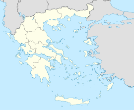
 Movri
MovriCoordinates 38°6′N 21°28′E / 38.1°N 21.467°ECoordinates: 38°6′N 21°28′E / 38.1°N 21.467°E Location within the peripheral unit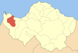
Government Country: Greece Region: West Greece Regional unit: Achaea Municipality: West Achaea Population statistics (as of 2001) Municipal unit - Population: 5,106 - Area: 86.48 km2 (33 sq mi) - Density: 59 /km2 (153 /sq mi) Other Time zone: EET/EEST (UTC+2/3) Elevation (center): 10 m (33 ft) Postal: 250 05 Telephone: 26930 Auto: ΑΧ Movri (Greek: Μόβρη) is a former municipality in Achaea, West Greece, Greece. Since the 2011 local government reform it is part of the municipality West Achaea, of which it is a municipal unit.[1] Population 5,106 (2001). It is named after the mountain range Movri. The seat of the municipality was in Sageika.
Subdivisions
The municipal unit Movri is subdivided into the following communities (constituent villages in brackets):
- Fragka (Fragka, Spaneika, Tsakonika)
- Kareika (Kareika, Gomosto, Karamesineika, Rachi)
- Krinos
- Limnochori (Limnochori, Kalamaki, Kato Limnochori, Paralia Kalamakiou)
- Myrtos (Myrtos, Giouleika, Pournari)
- Sageika (Sageika, Apostoli, Bouteika, Gerouseika, Vrachneika, Stathmos)
References
- ^ Kallikratis law Greece Ministry of Interior (Greek)
External links
- Municipality of Movri (Greek)
Subdivisions of the municipality of West Achaea Municipal unit of Dymi Agiovlasitika · Alissos · Ano Achaia · Elaiochori · Kato Achaia · Kato Alissos · Niforeika · PetrochoriMunicipal unit of Larissos Municipal unit of Movri Municipal unit of Olenia Achaiko · Agios Nikolaos Kralis · Agios Stefanos · Ano Soudenaiika · Arla · Chaikali · Charavgi · Fostaina · Galanaiika · Gkaneika · Kato Mazaraki · Lousika · Mitopoli · Portes · SantomeriCategories:- Populated places in Achaea
- West Greece geography stubs


Wikimedia Foundation. 2010.