- Dobbs Ferry (Metro-North station)
-
Dobbs Ferry 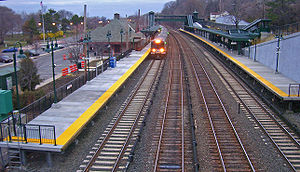
Southbound M7A EMU train stopping at Dobbs FerryStation statistics Address 11 Station Plaza, between
High & Palisades Streets
Dobbs Ferry, NY, 10522Lines Connections Bee-Line Bus System: 1C, 1T, 1W, 6, 66 Platforms 2 side platforms Tracks 4 Parking 576 Spaces Other information Electrified 700V (DC) third rail Fare zone 4 Services Preceding station Metro-North Railroad Following station toward Grand CentralHudson Line toward PoughkeepsieThe Dobbs Ferry Metro-North Railroad station serves residents of Dobbs Ferry, New York via the Hudson Line. Trains leave for New York City every 25 to 35 minutes on weekday rush-hour (peak trains). Trains run hourly during non-peak times, and on weekends and holidays. It is 19.9 miles from Grand Central Terminal and travel time to Grand Central is about 44 minutes by local train.
Platforms and tracks
This station has two high-level side platforms each eight cars long. The west platform next to Track 4 is generally used by southbound or Manhattan-bound trains. The east platform next to Track 3 is generally used by northbound or outbound trains.
The Hudson Line has four tracks; the two inner tracks not next to either platform are used by express trains. Only one of the express tracks is powered.
External links
- Metro-North Railroad - Dobbs Ferry
- List of upcoming train departure times and track assignments from MTA
- Station House from Google Maps Street View
- north entrance from Google Maps Street View
- Metro-North M1&M7 at Dobbs Ferry sta. on YouTube
Coordinates: 41°00′45″N 73°52′46″W / 41.012378°N 73.879487°W
Categories:- Metro-North Railroad stations in New York
- Stations along New York Central Railroad lines
- Transportation in Westchester County, New York
- New York railway station stubs

Wikimedia Foundation. 2010.