- Winehaven, California
Infobox_nrhp | name =Winehaven
nrhp_type =
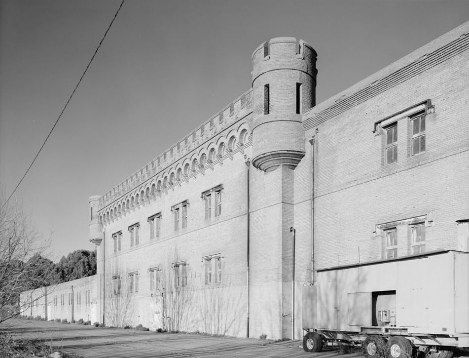
caption = Building 1 (storage cellar), Winehaven
location=Richmond, California
lat_degrees = 37 | lat_minutes = 57 | lat_seconds = 04.7 | lat_direction = N
long_degrees = 122 | long_minutes = 25 | long_seconds = 02.8 | long_direction = W
area =
built =1907
added =October 2 ,1978
governing_body = United States Navy
refnum=78000658 cite web|url=http://www.nr.nps.gov/|title=National Register Information System|date=2006-03-15|work=National Register of Historic Places|publisher=National Park Service]Winehaven was a
winery and town in Richmond,California , that held the title of "world's largest winery" for 12 years (1907–1919).cite web | url=http://www.cr.nps.gov/nr/travel/wwIIbayarea/win.htm | title=Winehaven (Point Molate) | work=World War II in the San Francisco Bay Area | publisher=National Park Service | accessdate=2007-04-09] It later became afuel depot for theUnited States Navy .After the
1906 San Francisco earthquake left the city in ruins, the "California Wine Association" moved to Point Molate, a promontory on the east shore ofSan Pablo Bay , and began construction of Winehaven. At the peak of the season, as many as 400 workers lived here, as all of the California Wine Association's shipments to foreign, coastal and New York markets sailed from the Winehaven dock--shipment capacity was 500,000 gallons (1,892,705 liters) a month, and 40 ships sailed annually for New York alone. The winery was shut down byProhibition in 1919; and the company sold off its assets to avoid bankruptcy. Winehaven went mostly unused from about 1920 until the late 1930s.The Navy bought the 412-
acre s (167 ha) site in 1941, moved into the winery buildings, and constructed 20 large concrete tanks on the hillsides above for a fuel depot. Thousands of drums of fuel were stored in huge buildings, pipelines were laid, a new pier was built and the old one was eventually removed. The old Winehaven Hotel was pressed into service for a period asbarracks andmess hall , and the workers' houses were renovated for the use of naval personnel. The Commanding Officer of the Naval Fuel Depot was assigned the largest house on the bluff overlooking the others, which previously had been the home of the winery superintendent.Despite the switch from wine to fuel, the historic district remains virtually unaltered from its days as a winery. There are 35 buildings in the National Register historic district built between 1907 and 1919, the most notable being the castle-like Winehaven Building adorned with crenellated
parapet and cornerturret s. Also within the district is the Winemaster's House (Building 60), which became the Commanding Officer's residence, and the Village of Point Molate, a row of turn-of-the-century cottages used to house Winehaven and military families. The Navy continued to operate the fuel depot during theKorean War andVietnam War until it was decommissioned in 1995.References
External links
* [http://www.ci.richmond.ca.us/index.asp?NID=113 Historical Sites in the City of Richmond]
* [http://www.ebls.org/pdf/Newsletter_Volume_1_Issue_2.pdf Good info on Winehaven is included here]
Wikimedia Foundation. 2010.