- Port Hedland, Western Australia
-
Port Hedland
Western Australia
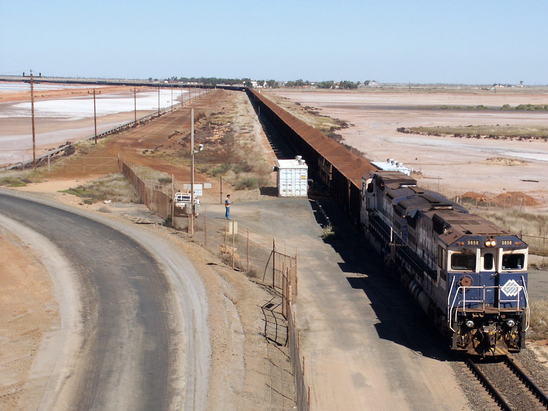
BHP iron ore train arriving into Port Hedland. The train is hauled by six locomotives (three pairs through the train).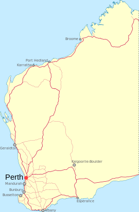
 Port Hedland
Population: 11,557(2006 census)[1] Established: 1880s Postcode: 6721 Coordinates: 20°18′36″S 118°36′04″E / 20.310°S 118.601°ECoordinates: 20°18′36″S 118°36′04″E / 20.310°S 118.601°E Elevation: 6 m (20 ft) Time zone: AWST (UTC+8) Location: 1322 km (821 mi) from Perth LGA: Town of Port Hedland State District: Pilbara Federal Division: Durack Mean max temp Mean min temp Annual rainfall 33.2 °C
92 °F19.4 °C
67 °F309.1 mm
12.2 inPort Hedland is the highest tonnage port in Australia [2] and largest town[3] in the Pilbara region of Western Australia, with a population of approximately 14,000 (this includes its satellite suburb South Hedland, 18 km away).
Port Hedland is a natural deep anchorage port which, as well as being the main fuel and container receival point for the region, was seen as perfect for shipment of the iron ore being mined in the ranges located inland from the town. The ore is moved by railway lines from four major iron ore deposits to the east and south of Port Hedland area. In August 2010 the port exported 13.6 million tonnes of iron ore.[4] Other major resource activities supported include the offshore natural gas fields, salt, manganese, and livestock. Grazing of cattle and sheep was formerly a major revenue earner for the region but this has slowly declined. Port Hedland was formerly the terminus for the WAGR Marble Bar Railway which serviced the gold mining area of Marble Bar.
Contents
History
 Iron ore mines in the Pilbara region.
Port Hedland is known by the Indigenous Kariyarra and Nyamal people as Marapikurrinya, which either means "place of good water" (as told by a Nyamal language speaker) and makes reference to the three reliable fresh water soaks that can still be seen in and around the town, or as the town council's website says "refers to the hand like formation of the tidal creeks coming off the harbour (marra - hand, pikurri - pointing straight and nya - a place name marker)".[5] According to Dreamtime legend there was a huge blind water snake living in the landlocked area of water known as Jalkawarrinya. This landlocked area is now the turning basin for the ships that enter the port and as the story goes, "the coming of the big ships meant it was unable to stay".
Though the coastline in the area had been explored in the 18th century, Captain Peter Hedland was one of the first Europeans to explore the harbour for the purpose of developing an export port. Peter Hedland arrived in the area in April 1863 onboard his boat, Mystery that he had built himself at Point Walter on the banks of the Swan River. He named the harbour Mangrove Harbour and reported that it would make a good landing site with a well protected harbour and that there was also fresh water available. What Hedland failed to point out was that the harbour was difficult to enter because of a huge sandbar that sealed the entrance meaning it was only accessible at high tide and that it was difficult to enter in bad weather because of the narrow entrance.[6]
In 1866, the resident Magistrate of Roebourne, Treverton Sholl, commissioned Charles Wedge to investigate alternative town sites to Roebourne. Wedge reported that Port Hedland's suitability was pessimistic. In 1891, exploration of the area by Tom Traine, John Wedge and Syd Hedley identified two landings and described the harbour as "pretty as well as safe". In September 1895, Cossack residents requested the District Surveyor to survey the headland at Port Hedland and requested the Government to build a jetty.
Goldsworthy Mining developed an iron ore mine approximately 100 kilometres east of Port Hedland in the early 1960s and built the towns of Goldsworthy and later Shay Gap as mine sites. A rail line was then built to Port Hedland where dredging was undertaken to deepen and widen the port's channel and a wharf was built opposite the township of Port Hedland on Finucane Island. Shipment of ore began on 27 May 1966 when the Harvey S Mudd sailed from Port Hedland to Japan with 24,900 tonnes of ore.
In 1967 iron ore was discovered at Mount Whaleback and a mining venture was undertaken that included the establishment of a new town, Newman, 426 km of rail from the mine to the port and the development of processing equipment at both Newman and Port Hedland. In 1986, at a cost of $87 million, the existing channel was dredged to allow the port to increase the tonnage of those ships able to enter the port. Prior to dredging the port was only able to load vessels less than 2,000 tonnes but today it is able to accommodate ships over 250,000 tonnes.
1968 plane crash
Main article: MacRobertson Miller Airlines Flight 1750On 31 December 1968, a Vickers Viscount operated by MacRobertson Miller Airlines crashed at nearby Indee Station. The plane had flown from Perth to Port Hedland without incident until about 10 minutes before landing it suffered a catastrophic right hand spar failure with the wing separating from the fuselage. All 26 on board, including the pilot, a first officer and 2 hostesses were killed.[7][8]
Geography and climate
The climate of Port Hedland is warm to hot, with mean maximum temperatures of 36.4 °C (97.5 °F) in January and 27.1 °C (80.8 °F) in July. Maximum temperatures in summer are usually moderated by a warm but humid sea breeze. Annual rainfall (falling almost exclusively between December and June) averages 311.5 mm (12.26 in) but because of erratic cyclones is subject to some of the largest variations in the world. As an illustration, in 1942 1,040 mm (41 in) fell, but in 1944 only 32 mm (1.3 in) fell and the town went for over 300 days with no rain[9]. The high summer temperatures experienced in Port Hedland mean that most tourists to the area choose to visit in the cooler months between May and September.
Temperatures
Climate data for Port Hedland Month Jan Feb Mar Apr May Jun Jul Aug Sep Oct Nov Dec Year Record high °C (°F) 49.0
(120.2)48.2
(118.8)45.9
(114.6)42.4
(108.3)38.8
(101.8)35.5
(95.9)34.4
(93.9)36.8
(98.2)42.2
(108.0)46.9
(116.4)47.4
(117.3)47.9
(118.2)49.0
(120.2)Average high °C (°F) 36.4
(97.5)36.2
(97.2)36.8
(98.2)35.2
(95.4)30.6
(87.1)27.6
(81.7)27.1
(80.8)29.1
(84.4)32.3
(90.1)34.8
(94.6)36.2
(97.2)36.7
(98.1)33.2 Average low °C (°F) 25.5
(77.9)25.5
(77.9)24.5
(76.1)21.4
(70.5)17.2
(63.0)14.2
(57.6)12.3
(54.1)13.2
(55.8)15.4
(59.7)18.3
(64.9)21.3
(70.3)24.0
(75.2)19.4 Record low °C (°F) 18.1
(64.6)16.3
(61.3)15.8
(60.4)12.2
(54.0)7.0
(44.6)4.7
(40.5)3.2
(37.8)3.7
(38.7)7.7
(45.9)11.1
(52.0)12.4
(54.3)16.6
(61.9)3.2
(37.8)Rainfall mm (inches) 57.9
(2.28)93.2
(3.669)48.7
(1.917)23.0
(0.906)27.2
(1.071)21.2
(0.835)11.1
(0.437)5.0
(0.197)1.3
(0.051)0.9
(0.035)2.5
(0.098)18.5
(0.728)309.1
(12.169)Source: Bureau of Meteorology[10] Located between Port Hedland and South Hedland are the large salt hills of Dampier Salt, a subsidiary of Rio Tinto. These large mounds have almost become a tourist attraction in their own right.
Immigration detention facility
In 1991 an immigration detention facility was opened at Port Hedland to deal with the arrival of boat people seeking asylum. Port Hedland was seen as a good location as it is in an area where many illegal boat people were entering Australia, and had an international airport that would allow for easy deportations when required. The Detention Centre was privatised by the John Howard Government in the late 1990s. The centre was closed in 2004 due to the falling numbers of asylum seekers arriving by boat to Australia's northwest. The town mayor called for the federal government to allow the town to use the detention centre to accommodate the many new mine workers needed in the town's current mining boom. A lack of accommodation makes it difficult for companies to operate efficiently as they are unable to house staff or consultants within the town's small number of hotels. The Detention Centre, which is situated on the beach front and was formerly single-men's quarters for Mount Newman Mining (now BHP Billiton).[11] The centre is now operating as the Beachfront.
Blackrock Stakes
The Blackrock Stakes is a 122 km race from Whim Creek to Port Hedland in which competitors, either in teams or as individuals, push a wheel barrows weighed down with iron ore. It was first run in 1971 and what developed has raised more than $1 million for charity and caused grown men, women and children to lump a wheelbarrow full of iron ore from a remote mine site and into Port Hedland.[12]
Teams of 10, trios, duos and lone runners now push modified wheelbarrows containing 11 kgs of iron ore over the distance.
See also
- Pilbara historical timeline
- Pilbara newspapers
- Port Hedland International Airport
- Port Hedland Saltworks Important Bird Area
References
- ^ Australian Bureau of Statistics (25 October 2007). "Port Hedland (Urban Centre/Locality)". 2006 Census QuickStats. http://www.censusdata.abs.gov.au/ABSNavigation/prenav/LocationSearch?collection=Census&period=2006&areacode=UCL523600&producttype=QuickStats&breadcrumb=PL&action=401. Retrieved 2009-08-31.
- ^ "Port Hedland Port Authority". http://www.phpa.com.au/. Retrieved 2006-12-03.
- ^ CityPopulation.de: Australia
- ^ "Port Hedland Aug iron ore exports fall 7.1 pct m/m". 14 September 2010. http://www.hellenicshippingnews.com/index.php?option=com_content&task=view&id=120648&Itemid=79. Retrieved 2010-09-15.
- ^ Town of Port Hedland (18 March 2005). "History". http://www.porthedland.wa.gov.au/town/history.html. Retrieved 2006-11-18.
- ^ Hardie, J. (1981). Nor'westers of the Pilbara Breed. Port Hedland, Western Australia: Shire of Port Hedland. ISBN 0-9594155-0-5.
- ^ "Port Hedland, Western Australia: Aircraft Crash". Emergency Management Australia disasters database. http://www.ema.gov.au/ema/emadisasters.nsf/c85916e930b93d50ca256d050020cb1f/2e2b655f537bf80bca256d33000583b9?OpenDocument. Retrieved 2008-10-29.
- ^ "Vickers Viscount aircrash near Port Hedland, 1968 - 26 dead". johnwilliambarnes.spaces.live.com/Blog. 11 April 2008. http://johnwilliambarnes.spaces.live.com/Blog/cns!BE3AFDE98176603D!906.entry. Retrieved 2008-10-30.
- ^ Port Hedland Post Office in 1944
- ^ "Climate statistics". http://www.bom.gov.au/climate/averages/tables/cw_004032_All.shtml. Retrieved 2009-03-01.
- ^ North West Telegraph, 7 February 2007
- ^ ABC Blackrock States broadcast.
External links
- Port Hedland
- WA Planning Commission - Land Use Survey (1999)
- Bureau of Meteorology: Port Hedland Meteorological Office
- Port Hedland Port Authority
Towns in the Pilbara region of Western Australia Cossack · Dampier · Goldsworthy · Jigalong · Karratha · Marble Bar · Newman · Nullagine · Onslow · Pannawonica · Paraburdoo · Point Samson · Port Hedland · Roebourne · Shay Gap · South Hedland · Telfer · Tom Price · Whim Creek · Wickham · Wittenoom
Cities of Western Australia Capital city Metropolitan cities Regional cities Large towns Iron ore mining in Western Australia BHP Billiton PortsPort Hedland (Nelson Point & Finucane Island)RailwaysGoldsworthy railway · Mount Newman railwayMinesFortescue Metals PortsPort Hedland (Herb Elliott Port)RailwaysFortescue railwayMinesRio Tinto Atlas Iron MinesPardoo mine · Wodgina mineOther operations MinesCockatoo Island · Jack Hills · Koolan Island · Koolanooka · Koolyanobbing · Tallering Peak Ports · Railways · MinesCategories:
- Towns in Western Australia
- Mining towns in Western Australia
- Port cities in Australia
- Ports and harbours of Western Australia
- Pilbara
- Coastal towns in Western Australia


Wikimedia Foundation. 2010.