- Last glacial period
-
"Last glacial" redirects here. For the period of maximum glacier extent during this time, see Last Glacial Maximum.
The last glacial period was the most recent glacial period within the current ice age occurring during the last years of the Pleistocene, from approximately 110,000 to 10,000 years ago.[1]
During this period there were several changes between glacier advance and retreat. The maximum extent of glaciation was approximately 18,000 years ago. While the general pattern of global cooling and glacier advance was similar, local differences in the development of glacier advance and retreat make it difficult to compare the details from continent to continent (see picture of ice core data below for differences).
From the point of view of human archaeology, it falls in the Paleolithic and Mesolithic periods.
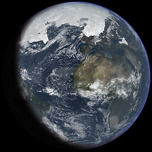 An artist's impression of the last glacial period at glacial maximum. Based on: "Ice age terrestrial carbon changes revisited" by Thomas J. Crowley (Global Biogeochemical Cycles, Vol. 9, 1995, pp. 377–389
Origin and definition
The last glacial period is sometimes colloquially referred to as the "last ice age", though this use is incorrect because an ice age is a longer period of cold temperature in which ice sheets cover large parts of the Earth, such as Antarctica. Glacials, on the other hand, refer to colder phases within an ice age that separate interglacials. Thus, the end of the last glacial period is not the end of the last ice age. The end of the last glacial period was about 12,500 years ago, while the end of the last ice age may not yet have come: little evidence points to a stop of the glacial-interglacial cycle of the last million years.
The last glacial period is the best-known part of the current ice age, and has been intensively studied in North America, northern Eurasia, the Himalaya and other formerly glaciated regions around the world. The glaciations that occurred during this glacial period covered many areas, mainly on the Northern Hemisphere and to a lesser extent on the Southern Hemisphere. They have different names, historically developed and depending on their geographic distributions: Fraser (in the Pacific Cordillera of North America), Pinedale, Wisconsinan or Wisconsin (in central North America), Devensian (in the British Isles), Midlandian (in Ireland), Würm (in the Alps), Mérida (in Venezuela), Weichselian (in Scandinavia and Northern Europe), Vistulian (in northern Central Europe), Valdai in Eastern Europe and Zyryanka in Siberia, Llanquihue in Chile, and Otira in New Zealand.
Overview
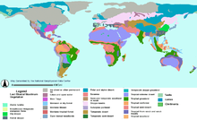 Vegetation types at time of last glacial maximum.
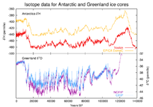
The last glaciation centered on the huge ice sheets of North America and Eurasia. Considerable areas in the Alps, the Himalaya and the Andes were ice-covered, and Antarctica remained glaciated.
Canada was nearly completely covered by ice, as well as the northern part of the USA, both blanketed by the huge Laurentide ice sheet. Alaska remained mostly ice free due to arid climate conditions. Local glaciations existed in the Rocky Mountains and the Cordilleran ice sheet and as ice fields and ice caps in the Sierra Nevada in northern California.[2] In Britain, mainland Europe, and northwestern Asia, the Scandinavian ice sheet once again reached the northern parts of the British Isles, Germany, Poland, and Russia, extending as far east as the Taimyr Peninsula in western Siberia.[3] The maximum extent of western Siberian glaciation was reached approximately 18,000 to 17,000 BP and thus later than in Europe (22,000–18,000 BP).[4] Northeastern Siberia was not covered by a continental-scale ice sheet.[5] Instead, large, but restricted, icefield complexes covered mountain ranges within northeast Siberia, including the Kamchatka-Koryak Mountains.[6][7]
The Arctic Ocean between the huge ice sheets of America and Eurasia was not frozen throughout, but like today probably was only covered by relatively shallow ice, subject to seasonal changes and riddled with icebergs calving from the surrounding ice sheets. According to the sediment composition retrieved from deep-sea cores there must even have been times of seasonally open waters.[8]
Outside the main ice sheets, widespread glaciation occurred on the Alps-Himalaya mountain chain. In contrast to the earlier glacial stages, the Würm glaciation was composed of smaller ice caps and mostly confined to valley glaciers, sending glacial lobes into the Alpine foreland. To the east the Caucasus and the mountains of Turkey and Iran were capped by local ice fields or small ice sheets.[9],[10] In the Himalaya and the Tibetan Plateau, glaciers advanced considerably, particularly between 47,000–27,000 BP[11] and in contrast to the widespread contemporaneous warming elsewhere.[12] The formation of a contiguous ice sheet on the Tibetan Plateau is controversial.[13][14][15]
Other areas of the Northern Hemisphere did not bear extensive ice sheets but local glaciers in high areas. Parts of Taiwan for example were repeatedly glaciated between 44,250 and 10,680 BP[16] as well as the Japanese Alps. In both areas maximum glacier advance occurred between 60,000 and 30,000 BP[17] (starting roughly during the Toba catastrophe). To a still lesser extent glaciers existed in Africa, for example in the High Atlas, the mountains of Morocco, the Mount Atakor massif in southern Algeria, and several mountains in Ethiopia. In the Southern Hemisphere, an ice cap of several hundred square kilometers was present on the east African mountains in the Kilimanjaro Massif, Mount Kenya and the Ruwenzori Mountains, still bearing remnants of glaciers today.[18]
Glaciation of the Southern Hemisphere was less extensive because of current configuration of continents. Ice sheets existed in the Andes (Patagonian Ice Sheet), where six glacier advances between 33,500 and 13,900 BP in the Chilean Andes have been reported.[19] Antarctica was entirely glaciated, much like today, but the ice sheet left no uncovered area. In mainland Australia only a very small area in the vicinity of Mount Kosciuszko was glaciated, whereas in Tasmania glaciation was more widespread.[20] An ice sheet formed in New Zealand, covering all of the Southern Alps, where at least three glacial advances can be distinguished.[21] Local ice caps existed in Irian Jaya, Indonesia, where in three ice areas remnants of the Pleistocene glaciers are still preserved today.[22]
Named local glaciations
Pinedale or Fraser glaciation, Rocky Mountains, USA
The Pinedale (central Rocky Mountains) or Fraser (Cordilleran ice sheet) glaciation was the last of the major glaciations to appear in the Rocky Mountains in the United States. The Pinedale lasted from approximately 30,000 to 10,000 years ago and was at its greatest extent between 23,500 and 21,000 years ago.[23] This glaciation was somewhat distinct from the main Wisconsin glaciation as it was only loosely related to the giant ice sheets and was instead composed of mountain glaciers, merging into the Cordilleran Ice Sheet.[24] The Cordilleran ice sheet produced features such as glacial Lake Missoula, which would break free from its ice dam causing the massive Missoula floods. Geologists estimate that the cycle of flooding and reformation of the lake lasted on average of 55 years and that the floods occurred approximately 40 times over the 2,000 year period between 15,000 and 13,000 years ago.[25] Glacial lake outburst floods such as these are not uncommon today in Iceland and other places.
Wisconsin glaciation, North America
The Wisconsin Glacial Episode was the last major advance of continental glaciers in the North American Laurentide ice sheet. At the height of glaciation the Bering land bridge potentially permitted migration of mammals, including people, to North America from Siberia.
It radically altered the geography of North America north of the Ohio River. At the height of the Wisconsin Episode glaciation, ice covered most of Canada, the Upper Midwest, and New England, as well as parts of Montana and Washington. On Kelleys Island in Lake Erie or in New York's Central Park, the grooves left by these glaciers can be easily observed. In southwestern Saskatchewan and southeastern Alberta a suture zone between the Laurentide and Cordilleran ice sheets formed the Cypress Hills, which is the northernmost point in North America that remained south of the continental ice sheets.
The Great Lakes are the result of glacial scour and pooling of meltwater at the rim of the receding ice. When the enormous mass of the continental ice sheet retreated, the Great Lakes began gradually moving south due to isostatic rebound of the north shore. Niagara Falls is also a product of the glaciation, as is the course of the Ohio River, which largely supplanted the prior Teays River.
With the assistance of several very broad glacial lakes, it carved the gorge now known as the Upper Mississippi River, filling into the Driftless Area and probably creating an annual ice-dam-burst.
In its retreat, the Wisconsin Episode glaciation left terminal moraines that form Long Island, Block Island, Cape Cod, Nomans Land, Marthas Vineyard, Nantucket, Sable Island and the Oak Ridges Moraine in south central Ontario, Canada. In Wisconsin itself, it left the Kettle Moraine. The drumlins and eskers formed at its melting edge are landmarks of the Lower Connecticut River Valley.
Tahoe, Tenaya, and Tioga, Sierra Nevada, USA
In the Sierra Nevada, there are three named stages of glacial maxima (sometimes incorrectly called ice ages) separated by warmer periods. These glacial maxima are called, from oldest to youngest, Tahoe, Tenaya, and Tioga.[26] The Tahoe reached its maximum extent perhaps about 70,000 years ago. Little is known about the Tenaya. The Tioga was the least severe and last of the Wisconsin Episode. It began about 30,000 years ago, reached its greatest advance 21,000 years ago, and ended about 10,000 years ago.
Greenland glaciation
In Northwest Greenland, ice coverage attained a very early maximum in the last glacial period around 114,000. After this early maximum, the ice coverage was similar to today until the end of the last glacial period. Towards the end glaciers readvanced once more before retreating to their present extent.[27] According to ice core data, the Greenland climate was dry during the last glacial period, precipitation reaching perhaps only 20% of today's value.[28]
Devensian & Midlandian glaciation, in Britain and Ireland
The name Devensian glaciation is used by British geologists and archaeologists and refers to what is often popularly meant by the latest Ice Age. Irish geologists, geographers, and archaeologists refer to the Midlandian glaciation as its effects in Ireland are largely visible in the Irish Midlands. The name Devensian is derived from the Latin Dēvenses, people living by the Dee (Dēva in Latin), a river on the Welsh border near which deposits from the period are particularly well represented.[29]
The effects of this glaciation can be seen in many geological features of England, Wales, Scotland, and Northern Ireland. Its deposits have been found overlying material from the preceding Ipswichian Stage and lying beneath those from the following Flandrian stage of the Holocene.
The latter part of the Devensian includes Pollen zones I-IV, the Allerød and Bølling Oscillations, and the Older and Younger Dryas climatic stages.
Alternative names include: Weichsel glaciation or Vistulian glaciation (referring to the Polish river Vistula or its German name Weichsel). During the glacial maximum in Scandinavia, only the western parts of Jutland were ice-free, and a large part of what is today the North Sea was dry land connecting Jutland with Britain. It is also in Denmark that the only Scandinavian ice-age animals older than 13,000 BC are found.[citation needed] In the period following the last interglacial before the current one (Eemian Stage), the coast of Norway was also ice-free.[citation needed]
The Baltic Sea, with its unique brackish water, is a result of meltwater from the Weichsel glaciation combining with saltwater from the North Sea when the straits between Sweden and Denmark opened. Initially, when the ice began melting about 10,300 ybp, seawater filled the isostatically depressed area, a temporary marine incursion that geologists dub the Yoldia Sea. Then, as post-glacial isostatic rebound lifted the region about 9500 ybp, the deepest basin of the Baltic became a freshwater lake, in palaeological contexts referred to as Ancylus Lake, which is identifiable in the freshwater fauna found in sediment cores. The lake was filled by glacial runoff, but as worldwide sea level continued rising, saltwater again breached the sill about 8000 ybp, forming a marine Littorina Sea which was followed by another freshwater phase before the present brackish marine system was established. "At its present state of development, the marine life of the Baltic Sea is less than about 4000 years old," Drs. Thulin and Andrushaitis remarked when reviewing these sequences in 2003.
Overlying ice had exerted pressure on the Earth's surface. As a result of melting ice, the land has continued to rise yearly in Scandinavia, mostly in northern Sweden and Finland where the land is rising at a rate of as much as 8–9 mm per year, or 1 meter in 100 years. This is important for archaeologists since a site that was coastal in the Nordic Stone Age now is inland and can be dated by its relative distance from the present shore.
Würm glaciation, the Alps
The term Würm is derived from a river in the Alpine foreland, approximately marking the maximum glacier advance of this particular glacial period. The Alps have been the area where first systematic scientific research on ice ages has been conducted by Louis Agassiz in the beginning of the 19th century. Here the Würm glaciation of the last glacial period was intensively studied. Pollen analysis, the statistical analyses of microfossilized plant pollens found in geological deposits, has chronicled the dramatic changes in the European environment during the Würm glaciation. During the height of Würm glaciation, ca 24,000–10,000 ybp, most of western and central Europe and Eurasia was open steppe-tundra, while the Alps presented solid ice fields and montane glaciers. Scandinavia and much of Britain were under ice.
During the Würm, the Rhône Glacier covered the whole western Swiss plateau, reaching today's regions of Solothurn and Aarau. In the region of Bern it merged with the Aar glacier. The Rhine Glacier is currently the subject of the most detailed studies. Glaciers of the Reuss and the Limmat advanced sometimes as far as the Jura. Montane and piedmont glaciers formed the land by grinding away virtually all traces of the older Günz and Mindel glaciation, by depositing base moraines and terminal moraines of different retraction phases and loess deposits, and by the pro-glacial rivers' shifting and redepositing gravels. Beneath the surface, they had profound and lasting influence on geothermal heat and the patterns of deep groundwater flow.
Merida glaciation, Venezuelan Andes
The name Mérida Glaciation is proposed to designate the alpine glaciation which affected the central Venezuelan Andes; during the Late Pleistocene. Two main moraine levels have been recognized: one between 2600 and 2700 m, and another between 3000 and 3500 m elevation. The snow line during the last glacial advance was lowered approximately 1200 m below the present snow line (3700 m). The glaciated area in the Cordillera de Mérida was approximately 600 km2; this included the following high areas from southwest to northeast: Páramo de Tamá, Páramo Batallón, Páramo Los Conejos, Páramo Piedras Blancas, and Teta de Niquitao. Approximately 200 km2 of the total glaciated area was in the Sierra Nevada de Mérida, and of that amount, the largest concentration, 50 km2, was in the areas of Pico Bolívar, Pico Humboldt (4,942 m), and Pico Bonpland (4,893 m). Radiocarbon dating indicates that the moraines are older than 10,000 years B.P., and probably older than 13,000 years B.P. The lower moraine level probably corresponds to the main Wisconsin glacial advance. The upper level probably represents the last glacial advance (Late Wisconsin).[30][31][32][33]
Llanquihue glaciation, southern Andes
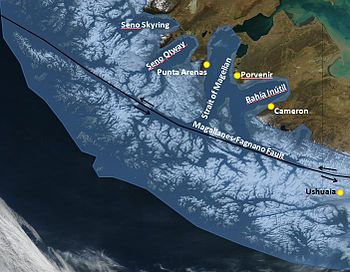 Map showing the extent of the Patagonian Ice Sheet in the Strait of Magellan area during the last glacial period. Selected modern settlements are shown with yellow dots.
The Llanquihue glaciation takes its name from Llanquihue Lake in southern Chile which is a fan-shaped piedmont glacial lake. On the lake's western shores there are large moraine systems of which the innermost belong to the last glacial period. Llanquihue Lake's varves are a node point in southern Chile's varve geochronology. During the last glacial maximum the Patagonian Ice Sheet extended over the Andes from about 35°S to Tierra del Fuego at 55°S. The western part appears to have been very active, with wet basal conditions, while the eastern part was cold based. Palsas seems to have developed at least in the unglaciated parts of Isla Grande de Tierra del Fuego. The area west of Llanquihue Lake was ice-free during the LGM, and had sparsely distributed vegetation dominated by Nothofagus. Valdivian temperate rainforest was reduced to scattered remnants in the western side of the Andes.[34]
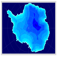 Modelled maximum extent of the Antarctic ice sheet 21,000 years before present
Antarctica glaciation
During the last glacial period Antarctica was blanketed by a massive ice sheet, much like it is today. The ice covered all land areas and extended into the ocean onto the middle and outer continental shelf.[35][36] According to ice modelling, ice over central East Antarctica was generally thinner than today.[37]
See also
- Glacial history of Minnesota
- Glacial lake outburst flood
- Glacial period
- Ice age
- Last Glacial Maximum
- Late Glacial Maximum
- Sea level rise
- Timeline of glaciation
- Valparaiso Moraine
References
- ^ Glaciation of Wisconsin, Lee Clayton, John W. Attig, David M. Mickelson, Mark D. Johnson, and Kent M. Syverson, University of Wisconsin, Dept. of Geology
- ^ Clark, D.H.: Extent, timing, and climatic significance of latest Pleistocene and Holocene glaciation in the Sierra Nevada, California. Ph.D. Thesis, Washington Univ., Seattle (pdf, 20 Mb)
- ^ Möller, P. et al.: Severnaya Zemlya, Arctic Russia: a nucleation area for Kara Sea ice sheets during the Middle to Late Quaternary. Quaternary Science Reviews Vol. 25, No. 21–22, pp. 2894–2936, 2006. (pdf, 11.5 Mb)
- ^ Matti Saarnisto: Climate variability during the last interglacial-glacial cycle in NW Eurasia. Abstracts of PAGES – PEPIII: Past Climate Variability Through Europe and Africa, 2001
- ^ Lyn Gualtieri et al.: Pleistocene raised marine deposits on Wrangel Island, northeast Siberia and implications for the presence of an East Siberian ice sheet. Quaternary Research, Vol. 59, No. 3, pp. 399–410, May 2003. Abstract: doi:10.1016/S0033-5894(03)00057-7
- ^ Zamoruyev, V., 2004. Quaternary glaciation of north-east Asia. In: Ehlers, J., Gibbard, P.L. (Eds.), Quaternary Glaciations: Extent and Chronology: Part III: South America, Asia, Africa, Australia, Antarctica. Elsevier, Netherlands, pp. 321–323.
- ^ Barr, I.D, Clark C.D. 2011. Glaciers and Climate in Pacific Far NE Russia during the Last Glacial Maximum. Journal of Quaternary Science. doi: 10.1002/jqs.1450
- ^ Robert F. Spielhagen et al.: Arctic Ocean deep-sea record of northern Eurasian ice sheet history. Quaternary Science Reviews, Vol. 23, No. 11-13, pp. 1455–1483, 2004. Abstract: doi:10.1016/j.quascirev.2003.12.015
- ^ Richard S. Williams, Jr., Jane G. Ferrigno: Glaciers of the Middle East and Africa – Glaciers of Turkey. U.S.Geological Survey Professional Paper 1386-G-1, 1991 (pdf, 2.5 Mb)
- ^ Jane G. Ferrigno: Glaciers of the Middle East and Africa – Glaciers of Iran. U.S.Geological Survey Professional Paper 1386-G-2, 1991 (pdf, 1.25 Mb)
- ^ Lewis A. Owen et al.: A note on the extent of glaciation throughout the Himalaya during the global Last Glacial Maximum, Quaternary Science Reviews, V. 21, No. 1, 2002, pp. 147–157. Abstract: doi:10.1016/S0277-3791(01)00104-4
- ^ Quaternary stratigraphy: The last glaciation (stage 4 to stage 2), University of Otago, New Zealand
- ^ Matthias Kuhle, 2002: A relief-specific model of the ice age on the basis of uplift-controlled glacier areas in Tibet and the corresponding albedo increase as well as their positiv climatological feedback by means of the global radiation geometry.- Climate Research 20: 1–7.
- ^ Matthias Kuhle, 2004: The High Glacial (Last Ice Age and LGM) ice cover in High and Central Asia. Development in Quaternary Science 2 (c, Quaternary Glaciation – Extent and Chronology, Part III: South America, Asia, Africa, Australia, Antarctica, Eds: Ehlers, J.; Gibbard, P.L.), 175–199. (Elsevier B.V., Amsterdam)..
- ^ Lehmkuhl, F.: Die eiszeitliche Vergletscherung Hochasiens – lokale Vergletscherungen oder übergeordneter Eisschild? Geographische Rundschau 55 (2):28–33, 2003. English abstract
- ^ Zhijiu Cui et al.: The Quaternary glaciation of Shesan Mountain in Taiwan and glacial classification in monsoon areas. Quaternary International, Vol. 97–98, pp. 147–153, 2002. Abstract: doi:10.1016/S1040-6182(02)00060-5
- ^ Yugo Ono et al.: Mountain glaciation in Japan and Taiwan at the global Last Glacial Maximum. Quaternary International, Vol. 138–139, pp. 79–92, September–October 2005. Abstract: doi:10.1016/j.quaint.2005.02.007
- ^ James A.T. Young, Stefan Hastenrath: Glaciers of the Middle East and Africa – Glaciers of Africa. U.S. Geological Survey Professional Paper 1386-G-3, 1991 (PDF, 1.25 Mb)
- ^ Lowell, T.V. et al.: Interhemisperic correlation of late Pleistocene glacial events, Science, v. 269,p. 1541-1549, 1995. Abstract (pdf, 2.3 Mb)
- ^ C.D. Ollier: Australian Landforms and their History, National Mapping Fab, Geoscience Australia
- ^ A mid Otira Glaciation palaeosol and flora from the Castle Hill Basin, Canterbury, New Zealand, New Zealand Journal of Botany. Vol. 34, pp. 539–545, 1996 (pdf, 340 Kb)
- ^ Ian Allison and James A. Peterson: Glaciers of Irian Jaya, Indonesia: Observation and Mapping of the Glaciers Shown on Landsat Images, U.S. Geological Survey professional paper; 1386, 1988. ISBN 0-607-71457-3
- ^ Brief geologic history, Rocky Mountain National Park
- ^ Ice Age Floods, From: U.S. National Park Service Website
- ^ Richard B. Waitt, Jr.: Case for periodic, colossal jökulhlaups from Pleistocene glacial Lake Missoula, Geological Society of America Bulletin, v.96, p.1271-1286, October 1985. Abstract
- ^ Alan R Gillespie and Paul H Zehfuss, 2004. "California", in Quaternary glaciations: extent and chronology, Volume 2, Ed. Jürgen Ehlers and Philip Leonard Gibbard, p. 57.Book
- ^ Svend Funder (ed.) Late Quaternary stratigraphy and glaciology in the Thule area, Northwest Greenland. MoG Geoscience, vol. 22, 63 pp., 1990. Abstract
- ^ Sigfus J. Johnsen et al.: A "deep" ice core from East Greenland. MoG Geoscience, vol. 29, 22 pp., 1992. Abstract
- ^ OED
- ^ * Schubert, Carlos (1998) "Glaciers of Venezuela" US Geological Survey (USGS P 1386-I)
- ^ Late Pleistocene glaciation of Páramo de La Culata, north-central Venezuelan Andes
- ^ Mahaney William C., Milner M. W., Kalm Volli, Dirsowzky Randy W., Hancock R. G. V., Beukens Roelf P.: Evidence for a Younger Dryas glacial advance in the Andes of northwestern Venezuela
- ^ Maximiliano B., Orlando G., Juan C., Ciro S.: Glacial Quaternary geology of las Gonzales basin, páramo los conejos, Venezuelan andes
- ^ http://www.esd.ornl.gov/projects/qen/nercSOUTHAMERICA.html South America during the last 150,000 years.
- ^ Anderson, J. B.; Shipp, S. S.; Lowe, A. L.; Wellner, J. S.; Mosola, A. B. (2002). "The Antarctic Ice Sheet during the Last Glacial Maximum and its subsequent retreat history: a review". Quaternary Science Reviews 21 (1–3): 49–70. doi:10.1016/S0277-3791(01)00083-X.
- ^ Ingolfsson, O. (2004). "Quaternary glacial and climate history of Antarctica". In Ehlers, J.; Gibbard, P. L.. Quaternary Glaciations: Extent and Chronology 3: Part III: South America, Asia, Africa, Australia, Antarctica. New York: Elsevier. pp. 3–43. http://www.hi.is/~oi/AG-326%202006%20readings/Antarctica/Ingolfsson_SUMMARY.pdf.
- ^ Huybrechts, P. (2002). "Sea-level changes at the LGM from ice-dynamic reconstructions of the Greenland and Antarctic ice sheets during the glacial cycles". Quaternary Science Reviews 21 (1–3): 203–231. doi:10.1016/S0277-3791(01)00082-8.
Further reading
- Bowen, D.Q., 1978, Quaternary geology: a stratigraphic framework for multidisciplinary work. Pergamon Press, Oxford, United Kingdom. 221 pp. ISBN 978-0-08-020409-3
- Ehlers, J., and P.L. Gibbard, 2004a, Quaternary Glaciations: Extent and Chronology 2: Part II North America. Elsevier, Amsterdam. ISBN 0-444-51462-7
- Ehlers, J., and P L. Gibbard, 2004b, Quaternary Glaciations: Extent and Chronology 3: Part III: South America, Asia, Africa, Australia, Antarctica. ISBN 0-444-51593-3
- Gillespie, A.R., S.C. Porter, and B.F. Atwater, 2004, The Quaternary Period in the United States [of America]. Developments in Quaternary Science no. 1. Elsevier, Amsterdam. ISBN 978-0-444-51471-4
- Harris, A.G., E. Tuttle, S.D. Tuttle, 1997, Geology of National Parks: Fifth Edition. Kendall/Hunt Publishing, Iowa. ISBN 0-7872-5353-7
- Matthias Kuhle, 1988: The Pleistocene Glaciation of Tibet and the Onset of Ice Ages- An Autocycle Hypothesis. In: GeoJournal 17 (4), Tibet and High-Asia I. 581–596.
- Mangerud, J., J. Ehlers, and P. Gibbard, 2004, Quaternary Glaciations : Extent and Chronology 1: Part I Europe. Elsevier, Amsterdam. ISBN 0-444-51462-7
- Sibrava, V., Bowen, D.Q, and Richmond, G.M., 1986, Quaternary Glaciations in the Northern Hemisphere, Quaternary Science Reviews. vol. 5, pp. 1–514.
- Pielou, E.C., 1991. After the Ice Age : The Return of Life to Glaciated North America. University Of Chicago Press, Chicago, Illinois. ISBN 0-226-66812-6 (paperback 1992)
External links
- National Atlas of the USA: Wisconsin Glaciation in North America: Present state of knowledge
- ncdc.noaa.gov
Ice ages Quaternary glaciation Current glaciationPleistocene glaciationPre-Quaternary glaciations Timeline of glaciation Categories:- Climate history
- Glaciology
- Ice ages
- Periods and stages in archaeology
- Pleistocene
- Holocene


Wikimedia Foundation. 2010.