- Pyllini
-
Pyllini
ΠυλλήνηLocation 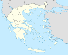
 Pyllini
Coordinates 38°32′N 21°49′E / 38.533°N 21.817°ECoordinates: 38°32′N 21°49′E / 38.533°N 21.817°E Location within the peripheral unit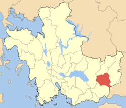
Government Country: Greece Region: West Greece Regional unit: Aetolia-Acarnania Municipality: Nafpaktia Population statistics (as of 2001) Municipal unit - Population: 2,000 - Area: 124.0 km2 (48 sq mi) - Density: 16 /km2 (42 /sq mi) Other Time zone: EET/EEST (UTC+2/3) Pyllini (Greek: Πυλλήνη or Πυλήνη) is a former municipality in Aetolia-Acarnania, West Greece, Greece. Since the 2011 local government reform it is part of the municipality Nafpaktia, of which it is a municipal unit.[1] Population 2,000 (2001). The seat of the municipality was in Simos.
Subdivisions
The municipal unit Pyllini is subdivided into the following communities (constituent villages in brackets):
- Famila (Platanias, Sykea, Famila)
- Anthofyto (Anthofyto, Leptokarya)
- Gavros (Gavros, Koutsogiannaiika)
- Dorvitsia
- Eleftheriani
- Milea
- Palaiopyrgos (Palaiopyrgos, Perivolia)
- Pokista
- Simos (Simos, Kampos, Palaiochori)
- Stranoma (Stranoma, Ano Kampos, Kato Kampos, Loutra Stachtis)
- Stylia (Stylia, Agia Tiada)
References
- ^ Kallikratis law Greece Ministry of Interior (Greek)
Municipal unit of Antirrio Municipal unit of Apodotia Ano Chora · Ampelakiotissa · Anavryti · Aspria · Elatovrysi · Elatou · Grammeni Oxya · Grigori · Kalloni · Katafygio · Kato Chora · Kentriki · Kokkinochori · Kryoneria · Kydonea · Lefka · Limnitsa · Mandrini · Podos · TerpsitheaMunicipal unit of Chalkeia Ano Vasiliki · Gavrolimni · Galatas · Kalavrouza · Perithori · Trikorfo · VasilikiMunicipal unit of Naupactus Municipal unit of Platanos Achladokastro · Agios Dimitrios · Arachova · Chomori · Dendrochori · Kastanea · Klepa · Livadaki · Neochori · Perdikovrysi · Perista · PlatanosMunicipal unit of Pyllini Anthofyto · Dorvitsia · Eleftheriani · Famila · Gavros · Milea · Palaiopyrgos · Pokista · Simos · Stranoma · StyliaCategories:- West Greece geography stubs
- Populated places in Aetolia-Acarnania


Wikimedia Foundation. 2010.