- Oberrüti
-
Oberrüti 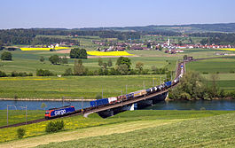
Country Switzerland 
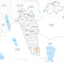
Canton Aargau District Muri 47°10′N 8°24′E / 47.167°N 8.4°ECoordinates: 47°10′N 8°24′E / 47.167°N 8.4°E Population 1,350 (Dec 2010)[1] - Density 251 /km2 (651 /sq mi) Area 5.37 km2 (2.07 sq mi)[2] Elevation 416 m (1,365 ft) Postal code 5647 SFOS number 4237 Surrounded by Dietwil, Hünenberg (ZG), Risch (ZG), Sins Website www.oberrueti.ch
SFSO statistics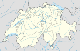
 OberrütiMap of Oberrüti
 The title of this article contains the character ü. Where it is unavailable or not desired, the name may be represented as Oberrueti.
Oberrüti is a municipality in the district of Muri in the canton of Aargau in Switzerland.
Contents
History
Oberrüti is first mentioned in 1236 as Ruty. In wasn't until the creation of the Canton of Aargau in 1803 that the name became Oberrüti.[3]
Oberrüti was part of the Habsburgs high court district of Meienberg. After the conquest of the Aargau in 1415, it became part of Lucerne. From 1425 until 1798 it was part of the Freie Ämter, which were governed as "subject lands" by all or some of the Confederates. The Twingherrschaft belonged to the Lords of Hünenberg. The Lords of Hünenberg also founded the village church of St. Ruprecht, which is first mentioned in 1275. After 1415 they sold the whole property to Ulrich Hertenstein, a citizen of Lucerne. He, then, ceded the rights to Kappel Abbey in 1448. From 1498 to 1798 the village government and church Jus patronatus or patronage rights were held by the city of Zug. In 1803 the Canton of Aargau was formed and Oberrüti became part of it. The ferry over the Reuss river was originally a Habsburg fief. It was in operation from 1413 until 1884.[3]
Geography
Oberrüti has an area, as of 2009[update], of 5.37 square kilometers (2.07 sq mi). Of this area, 3.76 km2 (1.45 sq mi) or 70.0% is used for agricultural purposes, while 0.82 km2 (0.32 sq mi) or 15.3% is forested. Of the rest of the land, 0.53 km2 (0.20 sq mi) or 9.9% is settled (buildings or roads), 0.15 km2 (37 acres) or 2.8% is either rivers or lakes and 0.07 km2 (17 acres) or 1.3% is unproductive land.[4]
Of the built up area, housing and buildings made up 5.0% and transportation infrastructure made up 3.7%. Out of the forested land, all of the forested land area is covered with heavy forests. Of the agricultural land, 45.6% is used for growing crops and 22.9% is pastures, while 1.5% is used for orchards or vine crops. All the water in the municipality is in rivers and streams. Of the unproductive areas, 1.3% is unproductive vegetation.[4]
The municipality is located in the Muri district, in the southern most portion of the canton. It is located along the Reuss. It consists of the village of Oberrüti and scattered small settlements and individual houses.
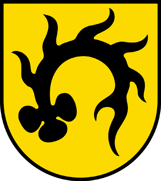
Coat of arms
The blazon of the municipal coat of arms is Or an Antler embowed Sable.[5]
Demographics
Oberrüti has a population (as of December 2010[update]) of 1,350[1] As of June 2009[update], 7.1% of the population are foreign nationals.[6] Over the last 10 years (1997–2007) the population has changed at a rate of 21.4%. Most of the population (as of 2000[update]) speaks German(97.2%), with Portuguese being second most common ( 0.6%) and English being third ( 0.5%).[7]
The age distribution, as of 2008[update], in Oberrüti is; 144 children or 11.8% of the population are between 0 and 9 years old and 230 teenagers or 18.9% are between 10 and 19. Of the adult population, 133 people or 10.9% of the population are between 20 and 29 years old. 138 people or 11.3% are between 30 and 39, 255 people or 21.0% are between 40 and 49, and 175 people or 14.4% are between 50 and 59. The senior population distribution is 80 people or 6.6% of the population are between 60 and 69 years old, 50 people or 4.1% are between 70 and 79, there are 10 people or 0.8% who are between 80 and 89,and there are 2 people or 0.2% who are 90 and older.[8]
As of 2000[update] the average number of residents per living room was 0.64 which is more people per room than the cantonal average of 0.57 per room. In this case, a room is defined as space of a housing unit of at least 4 m2 (43 sq ft) as normal bedrooms, dining rooms, living rooms, kitchens and habitable cellars and attics.[9] About 68.3% of the total households were owner occupied, or in other words did not pay rent (though they may have a mortgage or a rent-to-own agreement).[10]
As of 2000[update], there were 24 homes with 1 or 2 persons in the household, 134 homes with 3 or 4 persons in the household, and 199 homes with 5 or more persons in the household.[11] As of 2000[update], there were 381 private households (homes and apartments) in the municipality, and an average of 2.9 persons per household.[7] In 2008[update] there were 216 single family homes (or 46.6% of the total) out of a total of 464 homes and apartments.[12] There were a total of 7 empty apartments for a 1.5% vacancy rate.[12] As of 2007[update], the construction rate of new housing units was 3.3 new units per 1000 residents.[7]
In the 2007 federal election the most popular party was the SVP which received 32.4% of the vote. The next three most popular parties were the CVP (27.3%), the FDP (13.6%) and the SP (11.9%).[7]
The historical population is given in the following table:[3][8]
year population 1850 539 1900 409 1950 479 1980 506 1990 740 2000 1,097 Economy
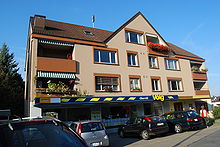 Volg Supermarket in Oberrüti
As of 2007[update], Oberrüti had an unemployment rate of 1.74%. As of 2005[update], there were 63 people employed in the primary economic sector and about 27 businesses involved in this sector. 83 people are employed in the secondary sector and there are 18 businesses in this sector. 95 people are employed in the tertiary sector, with 14 businesses in this sector.[7]
In 2000[update] there were 577 workers who lived in the municipality. Of these, 444 or about 76.9% of the residents worked outside Oberrüti while 93 people commuted into the municipality for work. There were a total of 226 jobs (of at least 6 hours per week) in the municipality.[13] Of the working population, 11.6% used public transportation to get to work, and 60.1% used a private car.[7]
Religion
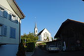 Church of Oberrüti
From the 2000 census[update], 803 or 73.2% were Roman Catholic, while 208 or 19.0% belonged to the Swiss Reformed Church.[11]
Education
In Oberrüti about 82.7% of the population (between age 25-64) have completed either non-mandatory upper secondary education or additional higher education (either university or a Fachhochschule).[7] Of the school age population (in the 2008/2009 school year[update]), there are 126 students attending primary school in the municipality.[11]
Oberrüti is home to the Schul-u.Gde.Bibliothek Oberrüti (school and municipal library of Oberrüti). The library has (as of 2008[update]) 1,190 books or other media, and loaned out 1,710 items in the same year. It was open a total of 81 days with average of 3 hours per week during that year.[14]
References
- ^ a b Canton of Aargau Statistical Office, MS Excel document – Bevölkerungsbestand per 31.12.2010 nach Gemeinde, Geschlecht u. Nationalität (German) accessed 11 May 2011
- ^ Arealstatistik Standard - Gemeindedaten nach 4 Hauptbereichen
- ^ a b c Oberrüti in German, French and Italian in the online Historical Dictionary of Switzerland.
- ^ a b Swiss Federal Statistical Office-Land Use Statistics 2009 data (German) accessed 25 March 2010
- ^ Flags of the World.com accessed 26-May-2010
- ^ Statistical Department of Canton Aargau -Bereich 01 -Bevölkerung (German) accessed 20 January 2010
- ^ a b c d e f g Swiss Federal Statistical Office accessed 26-May-2010
- ^ a b Statistical Department of Canton Aargau -Bevölkerungsdaten für den Kanton Aargau und die Gemeinden (Archiv) (German) accessed 20 January 2010
- ^ Eurostat. "Housing (SA1)" (pdf). Urban Audit Glossary. 2007. p. 18. http://www.bfs.admin.ch/bfs/portal/en/index/international/22/lexi.Document.116365.pdf. Retrieved 12 February 2010.
- ^ Urban Audit Glossary pg 17
- ^ a b c Statistical Department of Canton Aargau - Aargauer Zahlen 2009 (German) accessed 20 January 2010
- ^ a b Statistical Department of Canton Aargau (German) accessed 20 January 2010
- ^ Statistical Department of Canton Aargau-Bereich 11 Verkehr und Nachrichtenwesen (German) accessed 21 January 2010
- ^ Swiss Federal Statistical Office, list of libraries (German) accessed 14 May 2010
Abtwil | Aristau | Auw | Beinwil | Benzenschwil | Besenbüren | Bettwil | Boswil | Buttwil | Bünzen | Dietwil | Geltwil | Kallern | Merenschwand | Mühlau | Muri | Oberrüti | Rottenschwil | Sins | Waltenschwil
Aargau | Districts of Canton Aargau | Municipalities of the canton of Aargau
 Categories:
- Municipalities of Aargau
- Municipalities of Switzerland


Wikimedia Foundation. 2010.