- Cressbrook
-
Coordinates: 53°15′18″N 1°44′56″W / 53.255°N 1.749°W
Cressbrook 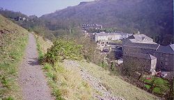
Looking down on the Cressbrook Mill complex, from the diverted Monsal Trail.
 Cressbrook
Cressbrook shown within DerbyshireOS grid reference SK168731 District Derbyshire Dales Shire county Derbyshire Region East Midlands Country England Sovereign state United Kingdom Post town BUXTON Postcode district SK17 Police Derbyshire Fire Derbyshire Ambulance East Midlands EU Parliament East Midlands List of places: UK • England • Derbyshire Cressbrook is a village in the Peak District National Park in Derbyshire. Before its Enclosure Act of 1762 Cressbrook did not exist. It later grew up around a textile mill complex built alongside the River Wye, first by Richard Arkwright and then later by his son Richard, JL Philips and Brother Cotton Spinners and McConnel and Company.
Until McConnel's period of ownership the village did not exist beyond a collection of buildings in the immediate vicinity of the mill. When McConnel's workforce objected to the quality of the housing available he took it upon himself to build the model village that has now become Cressbrook. Building started in the late 1830s and was later extended by Henry McConnel's daughter, Mary Worthington, in 1902 to include a village club, modelled on a working men's club. Cressbrook Mill became bankrupt in 1965, after which time it changed from being a private mill estate to the public village that it now is.
The Monsal Trail passes Cressbrook Mill. This 8.5 miles (13.7 km) walk and cycleway mostly follows the old trackbed of the Manchester, Buxton, Matlock and Midlands Junction Railway where, from 1866 to 1959, the village of Cressbrook was served by Monsal Dale railway station.[1] Today the tunnel at Cressbrook is closed for safety reasons, and the route diverts across the river Wye next to the Mill.
Publications
The history of Cressbrook was recently captured in the book Behind The View — Life and times in Cressbrook, a Derbyshire Mill village. This was written by and published by the Cressbrook Community association with the help of a grant from the Local Heritage Initiative, a Countryside Agency project.
References
- ^ Truman, P., Hunt, D., (1989) Midland Railway Portrait Sheffield: Platform 5 Publishing
External links
 Media related to Cressbrook at Wikimedia CommonsCategories:
- Towns and villages of the Peak District
- Villages in Derbyshire
- Derbyshire geography stubs


Wikimedia Foundation. 2010.