- Tirana County
-
Tirana County
Qarku i Tiranës— County —  Location of Tirana County within Albania.
Country  Albania
Number of Districts 2 Capital Tirana Government – Prefekt Lulzim Basha (PD) Area – Total 1,652 km2 (637.8 sq mi) Population (2010)[1] – Total 800,347 – Density 484.5/km2 (1,254.8/sq mi) Time zone CET (UTC+1) – Summer (DST) CEST (UTC+2) Website www.qarkutirane.gov.al The County of Tirana (Albanian: Qarku i Tiranës) is one of the 12 counties of Albania. It consists of the districts Kavajë and Tirana and its capital is Tirana. It has 800,347 inhabitants and with that it has the largest number of people of the Counties of Albania.[2]
Contents
History
The area now occupied by the city of Tirana has been populated since Paleolithic times[3] dating back 10,000 to 30,000 years ago, as evidenced by tools that were found near Mount Dajt's quarry terrain, as well as inside the Cave of the Pellumba. As argued by various archaeologists, Tirana and its suburbs are filled with Illyrian toponyms and legends as the city's precincts are some of the earliest regions in Albania to be inhabited.[4]
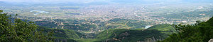 View of Tirana from Mount Dajt
Various remains discovered in fortresses, churches, villages, and during urban constructions in and around Tirana provide evidence for continuous activity throughout much of human history. The oldest discovery in the area of Tirana was a mosaic, dating back to the 3rd century A.D., with several other remains found at the Fountain of Shengjin, near a medieval temple. A castle, possibly called Tirkan or Theranda, was built by Emperor Justinian in 520 AD and restored by Ahmed Pasha Toptani in the 18th century.[4] The area had no special importance in Illyrian and classical times. In 1510, Marin Barleti, an Albanian Catholic priest and scholar, in the biography of the Albanian national hero Skanderbeg, Historia de vita et gestis Scanderbegi Epirotarum principis (The story of life and deeds of Skanderbeg, the prince of Epirotes), referred to this area as a small village.[5]
The records of the first land registrations under the Ottomans in 1431–32 show that Tirana consisted of 60 inhabited areas, with nearly 2,028 houses and 7,300 inhabitants. The 1583 census records show that Tirana had 110 inhabited areas, with 2,900 houses and 20,000 inhabitants. Sulejman Bargjini, a local ruler, established the Ottoman town in 1614 with a mosque, a commercial centre and a hammam (Turkish sauna). The town was located along caravan routes and it began to develop in the beginning of the 16th century, when a bazaar was established, and its craftsmen manufactured silk and cotton fabrics, leather, ceramics and iron, silver, and gold artifacts. Sited in a fertile plain, the Tirana area exported 2,600 barrels of olive oil and 14,000 packages of tobacco to Venice by 1769.
During this period, the Et'hem Bey Mosque built by Molla Bey of Petrela, began to be constructed. It employed the best artisans in the country and was completed in 1821 by Molla's son, who was also Sulejman Pasha's grandnephew. In 1800, the first newcomers arrived in the settlement, the so-called ortodoksit. They were Vlachs from villages of Korçë and Pogradec who settled around the area of today's Park on the Artificial Lake.[6] Later, they started to be known as the llacifac and were the first Christians to arrive after the foundation of the town. In 1807, Tirana became the center of the Sub-Prefecture of Krujë-Tirana. After 1816, Tirana languished under the control of the Toptani family of Krujë. In 1865, Tirana became a Sub-Prefecture of the newly created Vilayet of Shkodër and Sanjak of Durrës. The Albanian language started to be taught in Tirana's schools in 1889. The patriotic club "Bashkimi" was founded in 1908 while on November 28, 1912, the national flag was raised in agreement with Ismail Qemali. During the Balkan Wars, the town was temporarily occupied by the Serbian army, and in 1914–15, it took part in uprising of the villages led by Haxhi Qamili.
Geography
The County of Tirana covers an area of 1,652 km². The population was 781,087 in 2006, with a population density of 410 inhabitants per square kilometre. Its estimated population in 2010 is 800,347.[1][2]
Tirana County has a shoreline on the Adriatic Sea. On the land, it borders Durrës to the north, Dibër to the northeast, Elbasan to the southeast and Fier to the south.[1][2]
 Tirana by Spot Satellite
The main river flowing through Tirana County is the Ishëm River and the Tiranë River, which both flow through the city of Tirana itself. The city of Tirana's average altitude is 110 meters (360 ft) above sea level and its highest point measures 1,828 m (5,997.38 ft) at Mali me Gropa. The city is on the same parallel as Naples, Madrid and Istanbul and on the same meridian as Budapest and Krakow. The city of Tirana contains a total of four artificial lakes: the Tirana Artificial Lake around which was built the Big Park, the Kodër-Kamëz Lake, Farka Lake, and Tufina Lake.
 Erzen valley in Tirana County, viewed from Petrelë Castle
South of the city of Tirana is the Erzen valley, with its hills, olive groves, and surrounding mountains.[7] The town of Petrelë lies in this area and has a rich history, containing a tower which was built in the 5th century AD and which was used mostly to watch for Ottoman troops marching towards inner Albania.
The southern part of Tirana County, which borders Elbasan County is very mountainous and contains several lakes. More lakes, however, are located in the northwestern part of the county, north of Kavajë, including Kavajë Lake. The county borders the Adriatic Sea on the West where several beach side facilities exist. A well known is Plazhi i Gjeneralit Beach equipped with camping, wooden cabins, and catering facilities. Other beach areas are located near the village of Spille.
Dajti National Park is situated 26 km east of the capital of Tirana. The park has a surface area of 3,300 hectares. This park is highly frequented by day and is considered the 'Natural Balcony of Tirana'. The Dajti Mountain together with the south Priska Mountain (1353m) consists of the national park which has an exact area of 29,216.9 hectares.[8]
Politics and government
As of 2009, there are 32 representatives of Tirana County with setas in the Parliament of Albania out of 140.
Administrative divisions
District Capital District
Population (2010)[9]Area (km²) Municipalities Kavajë District Kavajë 82,921 414 Golem, Gosë, Helmës, Kavajë, Kryevidh, Lekaj, Luz i Vogël, Rrogozhinë, Sinaballaj, Synej Tirana District Tirana 717,426 1238 Baldushk, Bërxullë, Bërzhitë, Dajt, Farkë, Kamëz, Kashar, Krrabë, Ndroq, Paskuqan, Petrelë, Pezë, Prezë, Shëngjergj, Tirana, Vaqarr, Vorë, Zall-Bastar, Zall-Herr - Tirana District Region
Under a special constitutional dispensation, the Regional Council of Tirana has been formed as a local governing body. The council is in the heart of Tirana, which is called the Tirana District Region and covers an area of 33 km². It is delimited by the Durres District, Dibër District, Fier District, Elbasan District and the Adriatic Sea. This region with Mediterranean climate (mild winter and hot summer) has amazing beaches of the Adriatic coast in the vicinity of Kavaja and which is also famous for the Mediterranean flora and fauna. The district has a population of 887,567 of which 75% is urban and the balance 25% is a rural.[10]
Members
The following members are chosen:[11]
- Ferdinand Poni
- Suzana Guxholli
- Njazi Kosovrasti
- Dhori Kule
- Eneida Guria
- Besnik Aliaj
- Enkelejda Sallaku
- Bledi Kasmi
- Arjana Bekteshi
- Shezai Rrokaj
- Edmond Panariti
- Tahir Muhedini
- Maksim Begeja
- Agim Kraja
- Enver Reçi
Economy
 Bank of Albania
The city of Tirana is the economy heartland of Tirana County and the nation of Albania and is a major industrial centre. It has experienced rapid growth and established many new industries since the 1920s. The principal industries include agricultural products and machinery, textiles, pharmaceuticals, and metal products. It contains many of the important businesses and institutions including the Tirana Stock Exchange and the Tirana Bank, both of which have grown in productivity since 1996.
The TID tower at 85 meters is being constructed in the city. Tirana has several extensive shopping huge malls, such as City Park at 3 km² and the QTU Shopping Centre, located to the northwest of Tirana on the road to Durrës.
A partnership was instituted under USAID funding between the Tirana City and Catawba County of North Carolina (USA), which was extended in two phases between 2000–2004 and 2005–2007 for planning and implementing several management and development measures in Tirana, with expertise provided by the Catawba County. The improvements in the urban conglomerate covered wide disciplines of proper municipal budgeting and revenue generation, improvement of urban environment, particularly solid waste collection and management involving private sector participation for land fill operations of the Sharra landfill and improving infrastructure assets to match with growing urbanization of Tirana.[12]
Landmarks
 Skanderbeg Monument
 Left: Kavajë Mosque. Right: National Historical Museum.
Tirana contains many notable landmarks which are of major importance to the regional cultural heritage. These include Tirana Castle and national monuments such as the Skanderbeg Monument, Enver Hoxha Mausoleum, the Suleyman Pasha Tomb, the Tomb of Kapllan Pasha, Unknown Soldier and Mother Albania (statue). Outside of Tirana is Petrelë Castle.
The construction of Et'hem Bey Mosque commenced in 1789 by Molla Bey and it was finished in 1823 by his son Edhem Pasha (Haxhi Ethem Bey), great-grandson of Sulejman Pasha. During the totalitarianism of the Socialist People's Republic of Albania, the mosque was closed. However, on January 18, 1991, despite opposition from communist authorities, 10,000 people entered carrying flags during the fall of communism in Albania.[13] The frescoes of the mosque depict trees, waterfalls and bridges; still life paintings are a rarity in Islamic art. Tirana contains several important Christian places of worship such as the St Paul's Cathedral, Zemra e Krishtit Catholic Church, Resurrection of Christ Orthodox Cathedral of Tirana and Saint Procopius Church of Tirana. The church of Shën Premte, located in the village of Çetë in Kavajë District has also been a recognized Cultural Monument since 1963.[14] A notable mosque is located in Kavajë.
Most of the major museums in Tirana County are located in the city of Tirana. These include museums of national importance such as the National Historical Museum, National Gallery of Figurative Arts of Albania, Natural Sciences Museum of Albania, National Archaeological Museum, Ethnographic Museum and the National Archives of Albania. The National Archives were created in 1949 by Government decree and contains documents of national and international importance.[15] The main library in Tirana County is the National Library of Albania in Tirana, founded in 1920.[16] and inaugurated on December 10, 1922.[17]
Tirana Park on the Artificial Lake was built in the 1950s and was formerly called Park of Saint Procopius from the Saint Procopius Church of Tirana, that is located there. The park includes the Presidential Palace of Tirana, whose building was started by Zog of Albania. The park also includes Botanical Gardens of Tirana and Tirana Zoo and also a complex of swimming pools.[18]
Mount Dajti National Park
Main article: Mount DajtiMount Dajti National Park is situated 26 km east of the capital and 50 km east of the Mother Teresa Airport. The park has a surface area of 3,300 hectares. This park is highly frequented by day and is considered the 'Natural Balcony of Tirana'. The Dajti Mountain together with the south Priska Mountain (1353m) consists of the national park which has an exact area of 29,216.9 hectares.[8] The area of 3,300 acres (13 km2) protected since 1966 has been enlarged in 2006. The core zone is now 9,000 acres (36 km2). In addition to the forests and the beautiful mountain landscape with many wild flowers protection is provided to numerous mammals. In the park, there are wild boar, Eurasian wolf, red fox, European hare, brown bears and wildcats. In the lower part of the mountains, the vegetation is scrub determined with much heath, myrtle and fragaria. Around the 1,000 metres altitude zone, oak dominates. It follows with beech forests with some conifers. On the top there is almost no vegetation.
The mountain can be reached through a narrow asphalted mountain road onto an area known as Fusha e Dajtit. This was the location of a summer camp but now is the site of many restaurants. From this small area there is an excellent view of Tirana and its plain, that is the reason for calling the place as the Balcony of Tirana. From June 2005, hikers and visitors of the mountain can use a gondola lift from the eastern outskirts of Tirana to Fusha e Dajtit (the field of Dajti) at 1050 meters altitude. On the summit of Dajti there are several transmitters of radio and television. On Dajti, traces of prehistoric settlements have been found. Also, fortifications from later periods have been discovered.
Education
The majority of the important universities and education centres in Tirana County are located in Tirana. These include the University of Tirana, Agricultural University of Tirana, University of New York Tirana, Kristal University, Marin Barleti University, Marubi film school, Skanderbeg Military University, European University of Tirana, Luarasi University, Polytechnic University of Tirana, Academy of Physical and Sports Education Vojo Kushi and Tirana International School and many high schools. The Academy of Music and Arts of Albania and the Academy of Sciences of Albania are both located in Tirana; the Academy of Sciences of Albania has the country's largest academic library containing 8,120,000 volumes in 1986.[19][20]
Sports
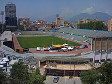 Qemal Stafa Stadium
Football is popular in Tirana County. Tirana has several notable football clubs such as KF Tirana, Partizani Tirana and Dinamo Tirana. There are several other clubs in Tirana County such as Besa Kavajë in Kavajë, founded in 1922 and KS Egnatia Rrogozhinë in Rrogozhinë, founded in 1964.[21] Major sports venues in Tirana are the Qemal Stafa Stadium, Selman Stërmasi Stadium and the Asllan Rusi Palace of Sports.
Transport
 Central Tirana with on the background Presidential Palace
Municipal, national and international transport links have developed in Tirana County over recent years. Until recent years, overland connections through Greece and Montenegro had many bureaucratic or security problems. The national roads SH1, SH2 and SH3 pass through the county and meet in Tirana city.[22] Tirana is yet to build an outer ring road that would drastically reduce traffic congestion in the city.
Bus
Local transport within Tirana is by bus or taxi. Group taxis (known as furgons) running multiple passengers operate on many pre-determined but unofficial routes and departure times are dictated by when sufficient passenger numbers justify running costs. Coach and minibus services also run, again according to demand, to the coast and northern and southern Albania from different locations in Tirana. International coach services connect to Greece, via Korçë or Kakavije, to Kosovo via the new Durrës-Morine highway, and to the Republic of Macedonia via Struga.
Rail
See also: Albanian Railways and Durrës–Tiranë railway Train passing through Tirana County on the way to Durrës
There are regular passenger services to Durrës and from Durrës to Pogradec, via Elbasan. The Tirana Railway Station is north of Skanderbeg Square, alongside the coach terminal at the north end of Boulevard Zogu I. There are no international passenger services, although there is a freight-only railway through Shkodër to Montenegro (though this is currently not in use).[23]
Air
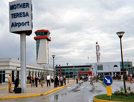
Tirana International Airport Mother Theresa (Nënë Tereza in Albanian), also known as Rinas Airport, is located 15 kilometres northwest of the city, off the road to Durrës and was reconstructed in 2007. The expansion resulted in an increased number of passengers per annum, estimated in 1.5M passengers for 2009.[24] It airlines using the airport include Albanian Airlines. Flights run to Athens, London, Rimini, Bari, Genoa, Rome, Bologna, Munich, Frankfurt, Istanbul, Vienna among other places. It is one of the biggest airports in the region. Several foreign airlines also serve Rinas Airport: Alitalia (from Rome and Milan), British Airways (from London Gatwick Airport), Austrian Airlines (from Vienna), Adria Airways (Ljubljana), Jat Airways (Belgrade), Lufthansa (Munich), Malev (Budapest), Olympic Air (Athens), Hemus Air (Sofia) and Turkish Airlines (Istanbul). In summer there is a direct charter flight from JFK, New York.
Sea
The nearest major port is at the Port of Durrës, that is 36 km distant from the Tirana city. Passenger ferries from Durrës sail to Trieste, Ancona, Otranto, Brindisi, Bari, Lecce, Genoa (Italy), Zadar, Dubrovnik (Croatia), Maribor, Koper (Slovenia), Gdansk (Poland), Bar (Montenegro), Corfu (Greece) and others.
Media
Most of the important media outlets in Tirana County are located in Tirana, including Tirana TV, TVSH, Club FM, Tirana, Albania Today, Dita and the Tirana Observer.
Notable people
Tirana
- Abdi bej Toptani, signatory of the Albanian Declaration of Independence
- Albert Brojka – Former Tirana Mayor
- Aleksandër Meksi – Former Prime Minister
- Bamir Topi – current President of Albania
- Beqir Balluku – Former member of the Politburo he was accused as organizer of a coup d'etat in 1974, and sentenced to death.
- Blendi Nallbani- football player
- Edi Rama – current Tirana Mayor
- Elsa Lila – singer
- Erjon Bogdani – football player
- Essad Pasha – politician
- Fatos Nano – former Prime Minister of Albania
- Gjergj Xhuvani – movie director
- Inva Mula – opera singer
- Kledi Kadiu – dancer and actor who lives and works in Italy
- Leka, Crown Prince of Albania – heir of King Zog I
- Masiela Lusha – actress, poet, and writer
- Murat bej Toptani, signatory of the Albanian Declaration of Independence
- Pandeli Majko – twice Prime Minister of Albania
- Rexhep Meidani – former President of Albania
- Saimir Kumbaro – film director
- Sali Kelmendi – Former Tirana Mayor
- Skënder Sallaku – comic actor
- Vedat Kokona – Albanian translator
- Klodiana Shala – Athlete
Kavajë
- Aleksander Moisiu, 20th Century Actor of European Stage and Cinema
- Spiro Moisiu, General Commander of the National Liberation Army during World War II
- Alfred Moisiu, 4th President of the Republic of Albania
- Mustafa Krantja, Famous Conductor and Founder of the Symphonic Orchestra
- Kristina Koljaka, First Albanian Female Sculptor and author of many notable works, the most famous of which was the Statue of Lenin in Central Tirana.
- Kolë Xhumari, Creator of the Children's Book also known as Abetare
- Ermir Dobjani, People's Advocate Ombudsman 2000–present
- Parashqevi Simaku, Popular singer of the 1980s
- Agim Hushi, Tenor
- Altin Rraklli, First Albanian Footballer to play in the Bundesliga
- Lorenc Goga, Weightlifter – Silver medal winner at the 1996 Summer Olympic Games in Atlanta, representing Greece as Leonidas Kokkas.
- Andi Lila, Defensive player of KF Tirana and capped with Albania
References
- ^ a b c "POPULLSIA SIPAS PREFEKTURAVE, 2001–2010". Albanian Institute of Statistics. http://www.instat.gov.al/graphics/doc/tabelat/Treguesit%20Sociale/Popullsia/POP%202009/t4%20.xls. Retrieved 2010-09-09.
- ^ a b c "Population by prefectures,1 January 2010". Government of Albania. http://www.instat.gov.al/graphics/doc/tabelat/Treguesit%20Sociale/Popullsia/POP%202009/t4%20.xls.
- ^ As argued by Prof. Dr. Muzafer Korkuti, an Albanian archeologists and researcher. "Tirane si qëndër e Historisë dhe Trashëgimisë Kulturore"
- ^ a b Heppner, Harald (1994). Hauptstädte in Südosteuropa: Geschichte, Funktion, nationale Symbolkraft. Wien u.a. Böhlau. pp. 133, 135. ISBN 9783205982555. http://books.google.com/?id=EzVfQTE-dD8C&pg=PA135&dq=Theranda+name&q=Theranda%20name.
- ^ To know more about the history of Tirana, please consult Tirana ne shekuj: Terona, Theranda, Tirkan, Tirannea, Tirana : monografi, disa artikuj e materiale arkivore kushtuar historisë së Tiranës by Skënder Jasa. (Victoria, 1997)
- ^ (Albanian) ""Tiranasit" e ardhur rishtaz". Gazeta Shqiptare. http://www.forumishqiptar.com/showthread.php?t=11897. Retrieved 2008-08-17.
- ^ "Petrela Castle". Albania.shqiperia.com. http://albania.shqiperia.com/kat/m/shfaqart/aid/2287/Petrela-Castle.html. Retrieved October 26, 2010.
- ^ a b "RRJETI I ZONAVE TE MBROJTURA NE SHQIPERI". Albanian Ministry of Environment, Forests and Water Administration. http://www.moe.gov.al/upload/zona%20te%20mbrojtura/Tabela-ZM-Maj-2010.pdf. Retrieved 2010-09-06.
- ^ "POPULLSIA SIPAS RRETHEVE, 2001–2010". Albanian Institute of Statistics. http://www.instat.gov.al/graphics/doc/tabelat/Treguesit%20Sociale/Popullsia/POP%202009/t2.xls. Retrieved 2010-09-09.
- ^ Regional Council of Tirana|accessdate=2010-10-26|publisher=Tirana County
- ^ [1]
- ^ "Tirana, Albania – Catawba County, NC Partnership" (pdf). USAID. http://pdf.usaid.gov/pdf_docs/PDACK691.pdf. Retrieved 2010-10-26.
- ^ Albania's economy in transition and turmoil, 1990–97 By Anthony Clunies Ross, Petar Sudar page 57 ([2])
- ^ "Objekte fetare me statusin: "Monument Kulture"" (in Albanian). REPUBLIKA E SHQIPËRISË KOMITETI SHTETËROR PËR KULTET. http://kshk.gov.al/index.php?fq=brenda&gj=gj1&kid=19. Retrieved October 26, 2010.
- ^ "Main Page AQSH". Central Archives of Albania. http://www.albarchive.gov.al/cms/front_content.php?client=1&changelang=3&idcat=139&changelang=2. Retrieved October 26, 2010.
- ^ Etleva Domi (June 23, 2003). National Library of Albania. Encyclopedia of Library and Information Science. doi:10.1081/E-ELIS-120008530. http://www.informaworld.com/smpp/content~content=a713531790~db=all~order=title. Retrieved October 26, 2010.
- ^ "Albanian National Bibliography". University of Illinois at Urbana-Champaign. http://www.library.uiuc.edu/spx/class/nationalbib/natbibalbania.htm. Retrieved October 26, 2010.
- ^ Gottschling, Anila. "What to visit in Tirana" (in Albanian). http://www.tirana-online.de/vizita.shtml. Retrieved October 26, 2010.
- ^ "Arta Academy". Art Academy. http://www.artacademy.al/. Retrieved November 1, 2010.
- ^ World Encyclopedia of Library and Information Services By Robert Wedgeworth Third Edition ISBN 0-8389-0609-5 Page 41
- ^ "KS Egnatia Rrogozhinë". Football.co.uk. http://www.football.co.uk/teams/albania/ks_egnatia_rrogozhine/index.shtml. Retrieved November 1, 2010.
- ^ Google. Google Maps (Map).
- ^ Metropol (18/05/2010). "Treni elektrik, Olldashi padit Spartak Poçin" (in Albanian). Metropol. http://www.gazetametropol.com/tekst.php?idt=65794. Retrieved 13 September 2010.
- ^ "Tirana Aiport records further growth in the first nine months of 2009". Tirana International Airport. http://www.tirana-airport.com/?RoseToken=160172155187150151177202197084168180238114147166153090150154149152154155089155156154160214184090168180231crc471. Retrieved November 1, 2010.
External links
Counties of Albania Municipalities of Tirana County Capital: TiranaKavajë District 
Tirana District Categories:


Wikimedia Foundation. 2010.