- Souris River
-
Souris River Mouse River, Rivière Souris  The Souris River in the town of Souris, Manitoba.
Countries  Canada,
  United States
States/Provinces  Saskatchewan,
  North Dakota,
  Manitoba
Tributaries - left Antler - right Gainsborough Cities Minot, ND, Souris, MB, Weyburn, SK, Melita, MB Mouth Assiniboine River - coordinates 49°39′54″N 99°34′07″W / 49.665°N 99.56861°W Length 435 mi (700 km) Basin 23,600 sq mi (61,124 km2)  The Red River drainage basin, with the Souris River highlighted
 Alameda Dam and Reservoir
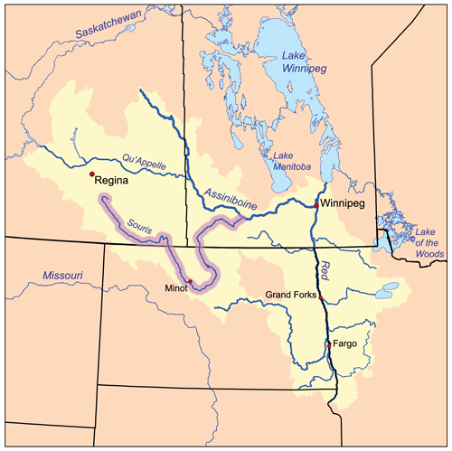
The Souris River (French: rivière Souris) or Mouse River (as it is alternatively known in the U.S.) is a river in central North America. It is about 700 km (435 mi) in length and drains about 23,600 square miles (61,100 km2). It rises in the Yellow Grass Marshes north of Weyburn, Saskatchewan. It wanders south through North Dakota beyond Minot to its most southern point at the city of Velva, ND and then back north into Manitoba. The river passes through the communities of Melita, Hartney, Souris and Wawanesa and on to its confluence with the Assiniboine River at Treesbank, about 25 miles (40 km) south east of Brandon. The main tributaries which flow into the Souris in Manitoba are the Antler River, the Gainsborough and Plum Creeks. Much of its drainage basin is fertile silt and clay deposited by former glacial Lake Souris.
The channel capacity of the river in Manitoba varies from about 150 cubic feet per second (4.2 m3/s) near the border, to about 1,400 cubic feet per second (40 m3/s) through Melita, to about 1,100 cubic feet per second (31 m3/s) near Lauder and 1,700 cubic feet per second (48 m3/s) near Hartney. North of Hartney the capacity increases to more than 3,000 cubic feet per second (85 m3/s). The drop between the border and Hartney is only about 6 inches per mile (9.5 cm/km).
During the period from 1930 to 1941 severe drought conditions prevailed and PFRA constructed four stock watering dams. In 1937 the Snyder and Ross Dams were built near Melita. In 1938 the Napinka Dam was built and the Hartney Dam was built in 1941. These were all stop log dams with a total capacity of 2,400 acre feet (3,000,000 m3). The Souris Dam was originally built in 1911 and was rebuilt in 1935. The Wawanesa Dam was completed in 1951 storing about 320 acre feet (390,000 m3) of water.
Most of the annual flow of the Souris River comes from snow melt and spring rains. The annual flow volume varies dramatically from 3,400 acre feet (4,200,000 m3) in 1937 to 2,100,000 acre feet (2.59 km3) in 1976. It is expected that the total runoff for 2011 at Wawanesa will exceed 3,800,000 acre feet (4.69 km3) about a one in 500 year event. The average annual runoff is equivalent to 3 mm over the entire Souris River watershed.[1]
Two large dams in Saskatchewan, Rafferty Dam and Alameda Dam were built, in part, to reduce flood peaks on the Souris River.
In summer 2011, a historic flood affected much of the Souris River basin, overtopping levees and causing the evacuation of about 11,000 residents in Minot as well as significant damage to farmland and other property along the length of the river.
Contents
Fish species
Fish species include walleye, yellow perch, northern pike, white sucker, black bullhead, brown bullhead and burbot.
Tributaries
- Long Creek
- Short Creek
- Moose Mountain Creek
- Des Lacs River
- Livingston Creek
- Wintering River
- Deep River
- Little Deep Creek
- Spring Coulee
- Cut Bank Creek (Cut Bank Creek (North Dakota))
- North Lake
- Egg Creek
- Hay Coulee
- Buffalo Lodge Lake
- South Egg Creek
- Egg Creek
- North Lake
- Little Deep Creek
- Willow Creek[disambiguation needed
 ]
]
- Snake Creek (North Dakota)
- Oak Creek[disambiguation needed ]
- Ox Creek
- Stone Creek[disambiguation needed ]
- Boundary Creek (North Dakota)
- Antler River
- Gainsborough Creek
Cities along the river
- Weyburn, Saskatchewan
- Estevan, Saskatchewan
- Roche Percee, Saskatchewan
- Oxbow, Saskatchewan
- Burlington, North Dakota
- Minot, North Dakota
- Velva, North Dakota
- Towner, North Dakota
- Westhope, North Dakota
- Melita, Manitoba
- Souris, Manitoba
- Wawanesa, Manitoba
Rural Municipalities along the river
- Souris Valley No. 7, Saskatchewan
See also
- List of rivers of Manitoba
- List of rivers of North Dakota
- List of rivers of Saskatchewan
References
- ^ Archived data from Water Survey Canada
External links
- USGS Canoeing Information
- International Joint Commission page on the Souris River
- Rafferty and Alameda Dams
- West Souris River Conservation District
- [1] Fish Species of Saskatchewan
- [2] Encyclopedia of Saskatchewan
Categories:- Rivers of Manitoba
- Rivers of North Dakota
- Rivers of Saskatchewan
- International rivers of North America
- Hudson's Bay Company trading posts


Wikimedia Foundation. 2010.