- Cologne Stadtbahn
-
KVB
 Stadtbahn
Info Locale Cologne (Köln)
GermanyTransit type light rail (Stadtbahn) Number of lines 11 Number of stations 222 Daily ridership 507,000[when?] Annual ridership 201,000,000,000[when?] Website www.kvb-koeln.de Operation Operator(s) Kölner Verkehrs-Betriebe (KVB) Number of vehicles 380[when?] Train length 60 meters (200 ft) Technical Track gauge 1,435 mm (4 ft 8 1⁄2 in) KVB system map 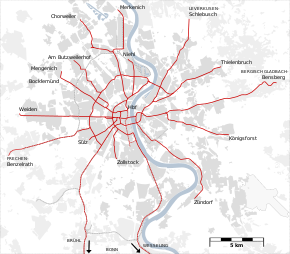
The Cologne Stadtbahn is a light rail system in the German city of Cologne, including several surrounding cities (Bergisch-Gladbach, Bonn, Bornheim, Brühl, Frechen, Hürth, Leverkusen-Schlebusch, Wesseling). The term Stadtbahn denotes a system that encompasses elements of streetcars as well as subways (U-Bahn) and interurban rail, even including three lines that are licensed as heavy rail and used by freight trains as well as Stadtbahn vehicles. Two of these lines connect the Cologne Stadtbahn to the Bonn Stadtbahn. These lines (16 and 18) are jointly operated by both cities' transport authorities, resulting in both systems and the lines connecting them sometimes collectively referred to as Stadtbahn Rhein-Sieg. The Cologne Stadtbahn is operated by the Kölner Verkehrsbetriebe (KVB) and the Bonn Stadtbahn is operated by the Stadtwerke Bonn (SWB - City of Bonn Utilities Division). The KVB and SWB are members of the Verkehrsverbund Rhein-Sieg (VRS - Rhein-Sieg Transit Authority, formed in 1987 to consolidate the transit authorities in the metropolitan Cologne area and operate a joint fare structure). There are 34 underground stations.
Contents
History
The Cologne Stadtbahn traces its history to the first horsecar lines that operated in Cologne since 1877. Within a few years, several companies had built an extensive network. Because none of these companies showed interest in electrifying their lines, the city of Cologne bought these companies effective 1 January 1900. Electric streetcars were introduced and additional lines built until 1912, including Vorortbahnen to surrounding villages outside the city limits. Outside the city center, these lines had separated right-of-way and were more similar to "real" railroads than to trams.
During World War II, Cologne suffered heavy damage. The city center was almost completely destroyed and the tram lines with it. After the war, there were only a few of the existing lines rebuilt in the downtown area, while at the same time automobile traffic increased heavily. To improve the situation, construction of the first tunnel began in 1963. When the tunnel was opened in November 1968, it was integrated into the tram network, instead of a separate subway operation. Since then, existing tram lines were gradually replaced with tunnels, some elevated track and surface lines with separated right of way. From 1973 until 2006 there have been light rail vehicles operating together with classic tram car on the same lines.
Underground construction in the downtown Cologne area is often obstructed by the fact that archeologists in Cologne, one of Germany's oldest cities, have legal rights to dig in all future building sites within the medieval city limits before all heavy construction machinery.
Current routes
 entrance to Friesenplatz station on Hohenzollernring
 technical map
Because the light rail network evolved from the tram network instead of replacing it, there were numerous stations served by both light rail and tram vehicles for almost three decades. While high platforms for stepless entry into light rail vehicles could be built on the outer branches, stations in the city center had to have low platforms to support trams as well. The introduction of low-floor technology in the early 1990s promised wheelchair-accessible entry throughout the network without having to build several hundred high platforms. To allow the introduction of low-floor trains without having to demolish existing high platforms, the network was divided into two sub-networks of different floor heights.
On weekdays, all lines are served in 5 to 10-minute intervals from 6 am to 8 pm, with little or no service between around 1 am and about 4.30 am, and usually 15-minute intervals in the early night and early morning. On weekends, there is an hourly service throughout the night. Because several lines overlap on the routes through the city center, some stations are served by up to 30 trains per hour in each direction.
route length avg. speed 1 Weiden West – Junkersdorf – Neumarkt – Bf Deutz - Kalk Post - Kalk Kapelle – Brück – Refrath - Bensberg
during peak hours 5-minute intervals Junkersdorf–Brück24.9 km (15.5 mi) 27.2 km/h (16.9 mph) 3 Mengenich – Bocklemünd – Bickendorf - Bf Ehrenfeld – Bf West – Neumarkt – Bf Deutz – Buchheim – Holweide – Thielenbruch
off-peak service ends at Holweide20.1 km (12.5 mi) 26.2 km/h (16.3 mph) 4 Bocklemünd – Bickendorf – Bf Ehrenfeld – Bf West – Neumarkt – Bf Deutz – Mülheim, Wiener Platz – Dünnwald - Schlebusch
evening service starts at Bickendorf21.5 km (13.4 mi) 28.0 km/h (17.4 mph) 5 Sparkasse Am Butzweilerhof - Ossendorf – Neuehrenfeld - Bf West – Dom/Hbf – Reichenspergerplatz 10.3 km (6.4 mi) 20.4 km/h (12.7 mph) 7 Frechen – Marsdorf – Braunsfeld – Neumarkt – Poll - Porz – Zündorf
Frechen–Braunsfeld served in 20-minute intervals except for peak hours25.5 km (15.8 mi) 25.5 km/h (15.8 mph) 9 Sülz – Universität – Bf Süd – Neumarkt – Bf Deutz – Kalk Post - Kalk Kapelle – Ostheim - Königsforst
5-minute intervals Universität–Bf Deutz except for school holidays15.4 km (9.6 mi) 25.0 km/h (15.5 mph) 12 Merkenich – Niehl – Ebertplatz – Hansaring – Ringe – Zollstock
Merkenich–Niehl served in 20-minute intervals from 9am to 1pm16.5 km (10.3 mi) 22.0 km/h (13.7 mph) 13 Sülzgürtel – Aachener Str. – Bf Ehrenfeld – Gürtel – Bf Mülheim – Buchheim - Holweide 15.4 km (9.6 mi) 28.9 km/h (18.0 mph) 15 Chorweiler – Longerich – Ebertplatz – Hansaring – Ringe – Ubierring
during peak hours 5-minute intervals Longerich–Ubierring15.2 km (9.4 mi) 24.0 km/h (14.9 mph) 16 Niehl, Sebastianstraße – Dom/Hbf – Neumarkt – Ubierring – Sürth – Wesseling – Bonn Hbf – Bonn-Bad-Godesberg
20-minute intervals from Sürth (during peak hours from Wesseling)44.4 km (27.6 mi) 33.3 km/h (20.7 mph) 18 Thielenbruch – Buchheim – Bf Mülheim – Dom/Hbf – Neumarkt – Klettenberg – Brühl – Bonn Hbf
5-minute intervals Buchheim–Klettenberg, 20-minute intervals from Brühl46.2 km (28.7 mi) 33.4 km/h (20.8 mph)  Appellhofplatz/Breite Straße station before renovation with a train
Low-floor lines
East-West lines

The first step towards the introduction of a low-floor light rail network was concentrating four lines on similar routes on a common east-west-corridor in 1994. Within short time, these lines were equipped with low platforms 35 cm above street level on every single station. While there are some stretches that can be described as classic tramway lines, the majority of the east-west-network has been upgraded to a high standard with long sections having separated right-of-way, justifying the term "low-floor light rail" (Niederflurstadtbahn).
In 2007, the 8 line, which previously operated during peak hours, stopped service. All its runs were integrated into the schedules of the lines 7 and 9.
1 Weiden West (S-Bahn) – Junkersdorf – Rheinenergiestadion – Aachener Straße/Gürtel – Rudolfplatz – Neumarkt – Deutz/Messe Rail – Kalk – Brück – Refrath – Bensberg 7 Frechen – Marsdorf – Aachener Straße/Gürtel – Rudolfplatz – Neumarkt – Poll – Porz – Zündorf 9 Sülz – Zülpicher Straße/Gürtel – University – Zülpicher Platz – Neumarkt – Deutz/Messe Rail – Kalk – Vingst – Ostheim – Rath/Heumar – Königsforst Ring lines

When it became clear to city authorities that the construction of a large number of additional high platforms was not financially feasible, other options were investigated. It was deemed most economical to create a second low-floor network and equip the remaining lines with high platforms. Between the stations "Ebertplatz" and "Barbarossaplatz", there are two possible routes. It was decided that the future low-floor lines would be concentrated in the tunnel underneath the Cologne Ring road, while high-floor lines would use the tunnel under the Central station.
This change was implemented in December 2003, after the high platforms at the Hansaring station were removed. In 2006, the tracks of the Chorweiler station were raised with additional gravel. Since then, all "Ringe" lines are operated with low-floor vehicles. In 2007, the line 6, which had only operated during peak hours, was replaced by additional trains of line 15.
12 Merkenich – Fordwerke – Wilh.-Sollmann-Straße – Ebertplatz – Friesenplatz – Barbarossaplatz – Eifelstraße – Zollstock 15 Chorweiler – Longerich – Wilh.-Sollmann-Straße – Ebertplatz – Friesenplatz – Barbarossaplatz – Eifelstraße – Chlodwigplatz – Ubierring High-floor lines
The high-floor network consists of all lines operated by "classic" light rail vehicles with a floor height of roughly one meter above street level. Since the separation from the low-Floor network. high platforms are being built in stations in the city center at a rate of one or two per year. As of 2009, the most frequented stations have been upgraded with the exception of the Barbarossaplatz station.
Lines 3 and 4, since the construction of temporary platforms at the Severinstraße station while the actual station gets modernized and connected to the North-Southern tunnel, are Cologne's first HF lines completely equipped with level entrance. The western branch of line 5 still has one station (Liebigstraße) without any platform at all, requiring passengers to climb into the trains from street level. Except a few stops, all of it's stations were made high-floor when the line was extended into the Butweilerhof industrial area.
Line 13 is also referred to as the "beltway" (Gürtel) line, because it is the only line that does not touch the city center. Most of the line runs along a series of roads of the same name. The northern part of the 13 is built as an elevated railway. High-floor platforms are still very rare on this line.
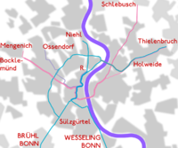
Lines 16 and 18 are the longest lines in the network, connecting Cologne to Bonn via railway lines.
3 Mengenich – Bocklemünd – Venloer Straße/Gürtel – Hans-Böckler-Platz – Friesenplatz – Neumarkt – Severinstraße – Deutz/Messe Rail – Buchheim – Holweide – Dellbrück – Thielenbruch 4 Bocklemünd – Venloer Straße/Gürtel – Hans-Böckler-Platz – Friesenplatz – Neumarkt – Severinstraße – Deutz/Messe Rail – Mülheim – Höhenhaus – Dünnwald – Schlebusch 5 Sparkasse Am Butzweilerhof - IKEA Am Butzweilerhof - Alter Flughafen Butzweilerhof – Subbelrather Str./Gürtel – Hans-Böckler-Platz – Friesenplatz – Dom/Central Station – Ebertplatz – Reichensperger Platz 13 Sülzgürtel – Zülpicher Straße/Gürtel – Dürener Straße/Gürtel – Aachener Straße/Gürtel – Venloer Straße/Gürtel – Subbelrather Straße/Gürtel – Nußbaumer Straße – Escher Straße –Neusser Straße/Gürtel – Amsterdamer Straße/Gürtel – Slabystraße – Mülheim – Buchheim – Holweide 16 Bonn-Bad Godesberg – Bonn Main Station – Wesseling – Sürth – Rodenkirchen – Ubierring – Barbarossaplatz – Neumarkt – Dom/Central Station – Ebertplatz – Reichensperger Platz – Niehl 18 Bonn Main Station – Brühl – Klettenberg – Sülzgürtel – Barbarossaplatz – Neumarkt – Dom/Central Station – Ebertplatz – Reichensperger Platz – Slabystraße – Mülheim – Buchheim – Holweide – Dellbrück – Thielenbruch Butzweilerhof extension (Line 5)
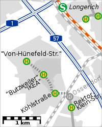
The Kölner Verkehrsbetriebe (KVB) constructed a new 185 km (115 mi) long extension from the former Ossendorf terminus into the Butzweilerhof/Gewerbegebiet Ossendorf area. 3 new stations (Alter Flughafen Butzweilerhof, IKEA am Butzweilerhof and the new terminus, Sparkasse Am Butzweilerhof) were added to the existing Line 5. Construction of the extension costed about €18 million, with 5 million euros being financed through the companies which will benefit from the extension. The remaining 13 million euros were financed by the KVB Köln (Cologne Transit Authority).
The extension begins near the former terminus Ossendorf, which has been removed, crosses the tracks of the HGK,[1] along the southern edge of the Hugo-Eckener-Strasse with the 1st station (Alter Flughafen Butzweilerhof) being placed at the corner of Hugo-Eckener-Strasse and Köhlstrasse; then along a newly constructed street which continues in an easternly direction from Köhlstraße. Traveling along the newly-built IKEA am Butzweilerhof retail center (location of the 2nd station), the track crosses another newly constructed street which emerges from the lengthed Richard-Byrd-Straße. The extension ends at the intersection of Richard-Byrd-Straße and Von-Hünefeld-Straße.
The extension opened on December 12, 2010.[2]
Future expansion
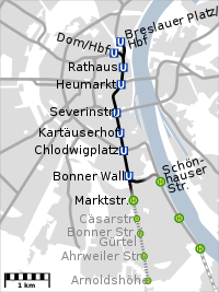
The current expansion project under construction is a new North-South tunnel (Nord-Süd-Stadtbahn, NSS). On March 3, 2009 the building of the City's archive collapsed into a Stadtbahn's tunnel under construction on the Severinstraße, killing two people.[3] Poor construction, the theft of necessary iron reinforcements and several ground water break-ins into the tunnel, which were not reported and not controlled properly by construction supervision, are among the alleged causes for this catastrophe.[3][4] Because of the ensuing delay in construction, the opening of the NSS is estimated for 2015 or even as late as 2017. In order to make use of already completed tunnels and stations, a shorter service running from Dom/Central Station to Rathaus (city hall) is planned to start operation in December 2012,[5] re-routing line 5 from its current terminus at Reichenspergerplatz to serve the new NSS. A further expansion to Heumarkt could be operated from 2013.[5] The extra cost of approximately 4 million Euros is planned to mitigate the negative perception of the NSS project due to the collapse as well as budget increases, late completion (originally planned for 2011) and disruption. Other partial openings are not deemed feasible before the complete opening in 2015/2017.[6]
The new 3 km long tunnel will be the first newly built line since the opening of the original downtown tunnel in 1968. Every line opened in between had been just a replacement for current or previous surface lines.
The oldest tunnel of the Cologne Stadtbahn is currently served by 30 trains per hour in each direction. Many consider this beyond the tunnel's capacity. Because the tunnel was built using a cut-and-cover technique, it follows major roads distant from the old city center with its narrow alleys. To solve both problems, an additional pair of tunnels was bored directly underneath the historic downtown areas. As a bonus, travel time of line 16 will decrease by about 10 minutes, because the NSS enables it to avoid the detour from Ubierring to Barbarossaplatz, only to return to the Rhine at the Central Station. It is also the final step in the separation of the high-floor and low-floor networks.
In order to avoid the possible destruction of archaeological artefacts underneath one of the oldest cities in Germany, the NSS was bored down to nearly 30 meters below ground level. At the location of the future stations however, archaeological digs were still required and are cited as one of the reasons for the already significant cost overruns. While initially estimated to cost around 600 million euro, the current price tag is calculated at around 960 million euros. Because the second stage, connecting the tunnel to the line along the Rhine river has not yet been tendered, but is expected to cost another 100 million, total cost is likely to exceed 1 billion euros.
Rolling stock
 Third-generation Type B LRV in new livery
 Two K5000 high-floor trams at Äußere Kanalstraße station
 New low-floor tram K4500 at its presentation on 18 April 2005
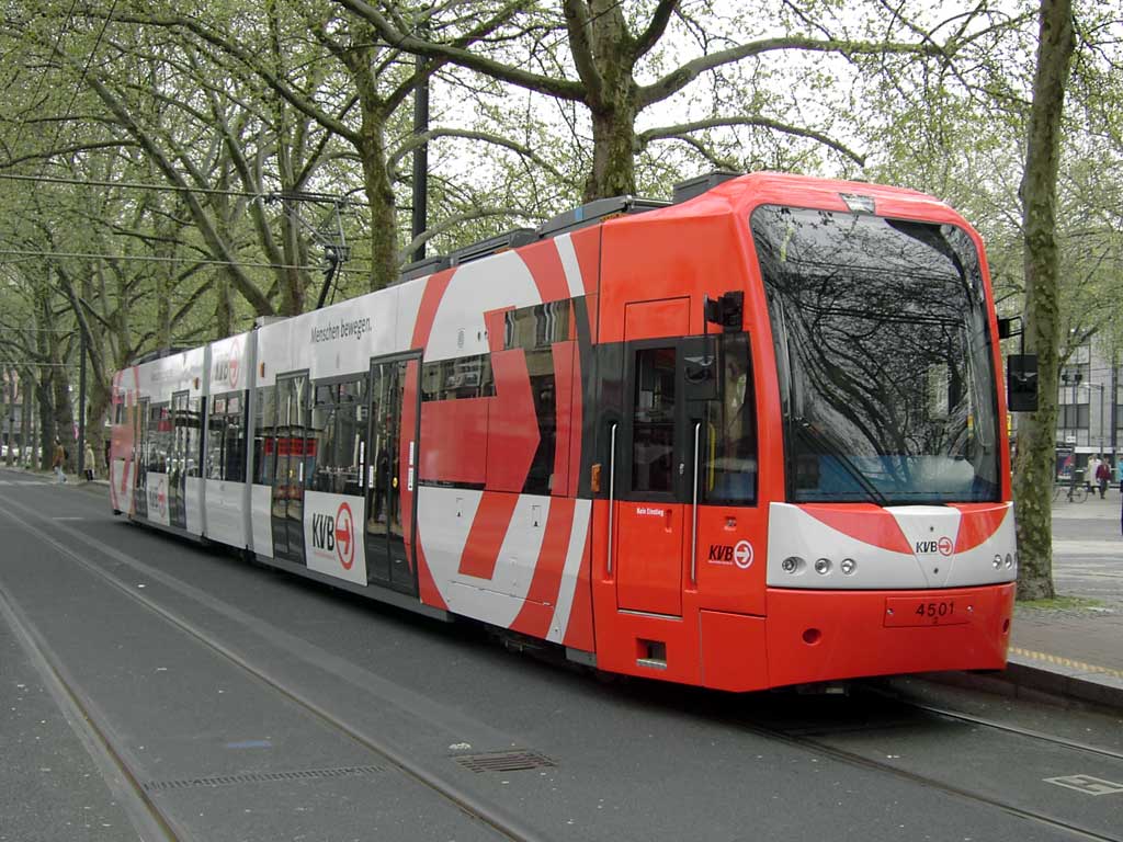
Since the last traditional tram cars were retired in 2006, the active rolling stock consists exclusively of light rail vehicles. All of them are slightly below 30 m (98 ft 5 in) long, 2.65 m (8 ft 8 in) wide, seat around 70 passengers and are approved for 80 km/h (50 mph) or more. With rare exceptions all services are operated by two units coupled together.
In 1973, Cologne received two prototypes of the Type B LRV. Since then, 172 units of four generations were delivered to Cologne until 1996. The first generation (series 2000) is currently being retired, while the second generation (series 2100) is due to receive a major overhaul for at least another 15 years of service.
After tests with a low-floor tram from Vienna, a similar vehicle was developed for Cologne by Bombardier Transportation, later known as the Flexity Swift family. A total of 124 low-floor trams were delivered between 1995 and 1998, referred to as "K4000". These vehicles received numbers starting with 4001.
When DUEWAG, producer of the Type B light rail vehicle was sold to Siemens Transportation Systems and later dissolved, additional Type B cars were no longer available. When a new series of high-floor vehicles, to be named "K5000", was needed, Siemens presented the "CitySprinter". In August 1999, after two months of testing, the CitySprinter prototype crashed into another tram at 50 km/h (30 mph) at the "Christophstraße/MediaPark" U-Bahn station. The accident was caused by a simultaneous electronics shutdown resulting in the train's inability to apply its brakes. Eight people sustained serious injuries. The second prototype produced was never delivered. Instead, Bombardier derived a high-floor tram from the K4000. 59 units were delivered in 2002 and 2003. The numbering was changed to 5101 at short notice to avoid re-using the number 5001, which had been the number of the ill-fated CitySprinter. Another 15 vehicles are exprected to be delivered before 2010.
When it was decided to create a second low-floor network, an option for more K5000 was changed to additional low-floor vehicles. Bombardier developed a new low-floor tram based more on the K5000 than on the K4000. These new trams were named "K4500". Delivery of 69 units started in 2005 and was completed in late 2007.
See also
- Transportation in Cologne
- List of Cologne KVB stations
- List of rapid transit systems
References
- ^ HGK English Site - Flash required
- ^ [1] http://kvb-koeln.de/german/nachrichten/view.html?action=shownews&id=1411
- ^ a b http://www.ksta.de/html/artikel/1266930835566.shtml
- ^ http://www.ksta.de/html/artikel/1277385900119.shtml
- ^ a b http://stadtbahn.relaunch.net/german/news/press.html?NID=737
- ^ http://www.koeln.de/koeln/nordsuedbahn_soll_2011_bis_zum_rathaus_fahren_352769.html
External links
 Media related to Stadtbahn Köln at Wikimedia Commons
- Kölner Verkehrsbetriebe Homepage
- Kölner Verkehrsbetriebe Timetable Search in English
- VRS/Rhein-Sieg Transit Authority Timetable Search in English
- Official Homepage for the Nord-Süd-U-Bahn Construction Project (in German only)
- German/English
- Christoph Groneck: Köln/Bonn Stadtbahn Album, Robert Schwandl Verlag 2005, ISBN 3-936573-07-7
- German
- Dieter Höltge/ Axel Reuther: Straßen- und Stadtbahnen in Deutschland Band 7: Köln, Düren, Aachen, EK-Verlag, 2001, ISBN 3-88255-338-3
- Doris Lindemann / Kölner Verkehrs-Betriebe (Hg): Kölner Mobilität - 125 Jahre Bahnen und Busse, Du Mont Verlag 2002, ISBN 3-8321-7177-0
Stadtbahn systems in Germany Bielefeld · Frankfurt am Main · Hanover · Rhein-Ruhr (Bochum · Dortmund · Düsseldorf · Essen · Gelsenkirchen · Herne · Mülheim) · Rhein-Sieg (Bonn · Cologne) · Stuttgart Categories:
- Transport in Cologne
- Light rail in Germany
- Tram transport in Germany
- Underground rapid transit in Germany


Wikimedia Foundation. 2010.