- Beach 67th Street (IND Rockaway Line)
-
Beach 67th Street

New York City Subway rapid transit station 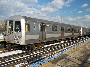
An train made up of R44 cars prior to their retirement, serving the stationStation statistics Address Beach 67th Street & Rockaway Freeway
Arverne, NY 11692Borough Queens Locale Arverne Coordinates 40°35′27″N 73°47′49″W / 40.590920°N 73.796810°WCoordinates: 40°35′27″N 73°47′49″W / 40.590920°N 73.796810°W Division B (IND, formerly LIRR Far Rockaway Branch) Line IND Rockaway Line Services A  (all times)
Connection - MTA Bus: Q22, QM17 (all on Beach Channel Drive)
Structure Elevated Platforms 2 side platforms Tracks 2 Other information Opened 1888 as an LIRR station
June 28, 1956 as subway stationFormer/other names Beach 67th Street – Arverne By The Sea
Beach 67 Street – GastonTraffic Passengers (2010) 473,942[1]  16.1%
16.1%Rank 404 out of 422 Station succession Next north Broad Channel: A
Beach 90th Street (via Hammels Wye): no regular serviceNext south Beach 60th Street: A Station service legend Symbol Description 
Stops in station at all times 
Stops all times except late nights 
Stops late nights only 
Stops late nights and weekends only 
Stops weekdays only 
Stops all times except rush hours in the peak direction Stops all times except weekdays 
Stops rush hours only 
Stops rush hours in the peak direction only 
Station is closed (Details about time periods) Beach 67th Street, sometimes referred as Beach 67th Street – Arverne By The Sea, is a station on the IND Rockaway Line of the New York City Subway. It is served by the A train at all times. There are two tracks and two side platforms.
The full time side of the station at the south end has four staircases, two to the street and one to each platform. The mezzanine layout gives evidence that there were originally separate turnstiles for entry and exit. The entry turnstiles are all on one side of the booth while the exit turnstiles are on the opposite side. Since the elimination of the double fare, steel gates have replaced the turnstiles. A sealed exit is at the north end of the Far Rockaway-bound platform and has a non-functional high wheel turnstile designed to collect single fares upon exiting. The extreme long length of this and other station platforms along the entire line is a legacy of its former use by the Long Island Rail Road before it transferred ownership to New York City Transit Authority in 1955.
Contents
History
The station was originally built as Arverne for the Long Island Rail Road in 1888 at Gaston Avenue, by New York lawyer and developer Remington Vernam. The station and the development were named by his wife who admired the way he signed his checks. The station had a large tower, was shaped like a Victorian hotel and had a connection to the Ocean Electric Railway. Due to a quarrel between the LIRR and Vernam, another Arverne Station was built at Stration Avenue in 1892. From then on, it was known as Arverne – Gaston Avenue to distinguish it from the Straiton Avenue station. Arverne station was rebuilt on a new site with a simpler structure in May 1912. Like all stations along the Rockaway Beach Branch, it was closed and replaced with the elevated Gaston Avenue (LIRR station) on April 10, 1942, only to be transferred to the New York City Transit Authority on October 3, 1955 and reopened as a subway station on June 28, 1956.[2]
Community Board 14 has voted in favor of renaming the station to Beach 67th Street – Arverne By The Sea. New signs with this name were installed in July 2011.[3]
Leaving the station northbound, trains reach the Hammels Wye, where it is possible to head north to Broad Channel (the usual service pattern) or traverse a short single-track segment onto the southbound Rockaway Park-bound branch of the line. This connection is not currently used in revenue service.
Gallery
-

South platform looking east
-

Street stair
References
- ^ "Facts and Figures: 2010 Annual Subway Ridership". New York City Metropolitan Transportation Authority. http://mta.info/nyct/facts/ridership/ridership_sub_annual.htm. Retrieved 2011-05-18.
- ^ LIRR Station History
- ^ "Beach 67 Street Station – Arverne By The Sea," by Nicholas Briano (The Wave; March 12, 2010)
External links
- nycsubway.org — IND Rockaway: Beach 67th Street/Gaston Avenue
- Station Reporter — A Rockaway
- The Subway Nut — Beach 67th Street – Gaston Pictures
- Beach 67th Street entrance from Google Maps Street View
Categories:- IND Rockaway Line stations
- New York City Subway stations in Queens
- Railway stations opened in 1956


Wikimedia Foundation. 2010.