- Fezile Dabi District Municipality
-
Fezile Dabi — District municipality — Location of Fezile Dabi District Municipality within Free State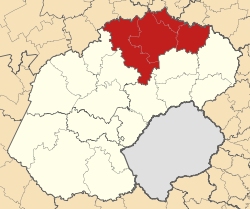
Coordinates: 26°49′S 27°49′E / 26.817°S 27.817°ECoordinates: 26°49′S 27°49′E / 26.817°S 27.817°E Country  South Africa
Province Free State Seat Sasolburg Neighbors Government – Mayor Jonas Ramokhoase (ANC) Area – Total 21,301 km2 (8,224.4 sq mi) Population – Total 460,289 – Density 21.6/km2 (56/sq mi) Racial makeup – Black 85.71% – White 12.19% – Coloured 1.99% Languages – Sesotho 67.99% – Afrikaans 13.56% – Xhosa 7.58% Time zone SAST (UTC+02) Municipal code DC20 Website nfsdc.co.za Fezile Dabi District Municipality, formerly known as Northern Free State District Municipality, is one of the 5 districts of Free State province of South Africa. The seat of Northern Free State is Sasolburg. The majority of its 460 289 people speak Sesotho (2001 Census). The district code is DC20.
Contents
Geography
Neighbours
Northern Free State is surrounded by:
- Sedibeng in Gauteng to the north (DC42)
- Gert Sibande in Mpumalanga to the north-east (DC30)
- Thabo Mofutsanyane to the south-east (DC19)
- Lejweleputswa to the west (DC18)
- Dr Kenneth Kaunda in North-West to the north-west (DC40)
Local municipalities
The district contains the following local municipalities:
Local municipality Population % Moqhaka 167 886 36.47% Ngwathe 118 820 25.81% Metsimaholo 115 964 25.19% Mafube 57 637 12.52% Demographics
The following statistics are from the 2001 census.
Language Population % Sesotho 312 962 67.99% Afrikaans 62 430 13.56% IsiXhosa 34 888 7.58% IsiZulu 31 229 6.78% Setswana 6 121 1.33% English 4 749 1.03% Sepedi 2 628 0.57% SiSwati 1 537 0.33% IsiNdebele 1 243 0.27% Xitsonga 1 241 0.27% Other 757 0.16% Tshivenda 522 0.11% Gender
Gender Population % Female 233 921 50.82% Male 226 368 49.18% Ethnic group
Ethnic group Population % Black African 394 519 85.71% White 56 094 12.19% Coloured 9 174 1.99% Indian/Asian 502 0.11% Age
Age Population % 000 - 004 41 558 9.03% 005 - 009 43 971 9.55% 010 - 014 49 984 10.86% 015 - 019 51 062 11.09% 020 - 024 42 606 9.26% 025 - 029 39 124 8.50% 030 - 034 34 867 7.58% 035 - 039 32 496 7.06% 040 - 044 28 301 6.15% 045 - 049 24 171 5.25% 050 - 054 19 601 4.26% 055 - 059 14 915 3.24% 060 - 064 12 049 2.62% 065 - 069 9 577 2.08% 070 - 074 7 059 1.53% 075 - 079 4 119 0.89% 080 - 084 2 922 0.63% 085 - 089 1 249 0.27% 090 - 094 469 0.10% 095 - 099 132 0.03% 100 plus 57 0.01% Politics
Election results
Election results for Northern Free State in the South African general election, 2004.
- Population 18 and over: 293 994 [63.87% of total population]
- Total votes: 182 833 [39.72% of total population]
- Voting % estimate: 62.19% votes as a % of population 18 and over
Party Votes % African National Congress 146 691 80.23% Democratic Alliance 20 395 11.15% Freedom Front Plus 4 210 2.30% United Democratic Movement 2 326 1.27% African Christian Democratic Party 2 265 1.24% New National Party 1 511 0.83% Pan African Congress 1 449 0.79% Independent Democrats 1 097 0.60% Azanian People's Organisation 894 0.49% Inkhata Freedom Party 749 0.41% United Christian Democratic Party 301 0.16% SOPA 203 0.11% NA 167 0.09% CDP 126 0.07% EMSA 109 0.06% PJC 94 0.05% UF 84 0.05% TOP 60 0.03% KISS 35 0.02% NLP 34 0.02% Minority Front 33 0.02% Total 182 833 100.00% References
- Municipal Demarcation Board
- Stats SA Census 2001 page
- Independent Electoral Commission 2004 election results
Province of Free State, South Africa Provincial Capital: BloemfonteinMetropolitan
MunicipalityDistrict
and Local
MunicipalitiesThabo MofutsanyanaFezile DabiCategories:- District municipalities of the Free State (South African province)

Wikimedia Foundation. 2010.