- Durham Area Transit Authority
-
Durham Area Transit Authority 
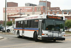
Headquarters 1907 Fay Street Locale Durham, NC Service type bus service, paratransit Hubs Durham Station Transportation Center Fleet 53 Operator MV Transportation Web site DATA Homepage  DATA bus on Chapel Hill St in Durham.
Durham Area Transit Authority (DATA) is the public transit system serving Durham, North Carolina.
The fixed-route system incorporates 165 employees and 53 buses transporting more than 13,000 daily riders on 18 routes. The paratransit system includes 43 vans and 57 employees transporting clients to various places within the city and nearby Chapel Hill.
DATA operates 48 full-sized and 5 22-seat Goshen Cutaway buses on 18 routes. All of the full-size buses are of Gillig manufacture and are dual-door low-floor. The fleet livery is white with red, blue and yellow striped relief. Bicycle racks are fitted to the front of all buses. 20 Gillig BRT hybrid 40-foot buses are on order for September 2009 delivery.[citation needed]
There is a flat fare system US$1, $2 for unlimited one-day pass; senior citizens ride free. The system's service contracts are let for five years.
Most routes depart/arrive at the downtown terminal at the top of the hour and every half hour from 5:30 a.m. until 12:30 a.m., Monday through Saturday, and from 7:30 a.m. to 7:30 p.m. Sunday. There is no service Christmas day.
The downtown terminal was relocated to a new transportation center (Durham Station) that also serves Triangle Transit Authority and Greyhound Lines buses on February 23, 2009. The building was designed by the Freelon group.
History
The City of Durham assumed the operation of the local Duke Power bus system in 1991, naming it Durham Area Transit Authority (DATA).
- 1891-1902 - Durham Street Railway Co.
- 1902-1913 - Durham Traction Co.
- 1913-1921 - Durham Traction Co. (Cities Service Co.)
- 1921-1943 - Durham Public Service Co. (Cities Service Co.)
- 1930 - streetcars discontinued
- After 1943 - Duke Power Company
Routes
No. Destination 1 Northgate Mall and North Pointe 2 East Durham and Highway 70 3 Holloway Street and The Village 4 Durham Regional Hospital and N. Roxboro Road 5 Fayetteville Street and South Square 6 Duke University and VA Hospital 7 Fayetteville Road and The Streets at Southpoint 8 McDougald Terrace and Durham Technical Community College 9 Dearborn Drive and Durham Regional Hospital 10 Woodcroft and New Hope Commons 11 Duke University and Hillsborough Road 12 Highway 55 and Highway 54 12B Lowe's Grove 13 Durham Technical Community College and The Village 15 Alston Avenue - Brier Creek 16 Southern High School and The Village 16B Neal Middle School 17 Snow Hill Road and Horton Road External links
Categories:- Bus transportation in North Carolina
- Transit authorities with hybrid buses
- Transportation in Durham, North Carolina


Wikimedia Foundation. 2010.