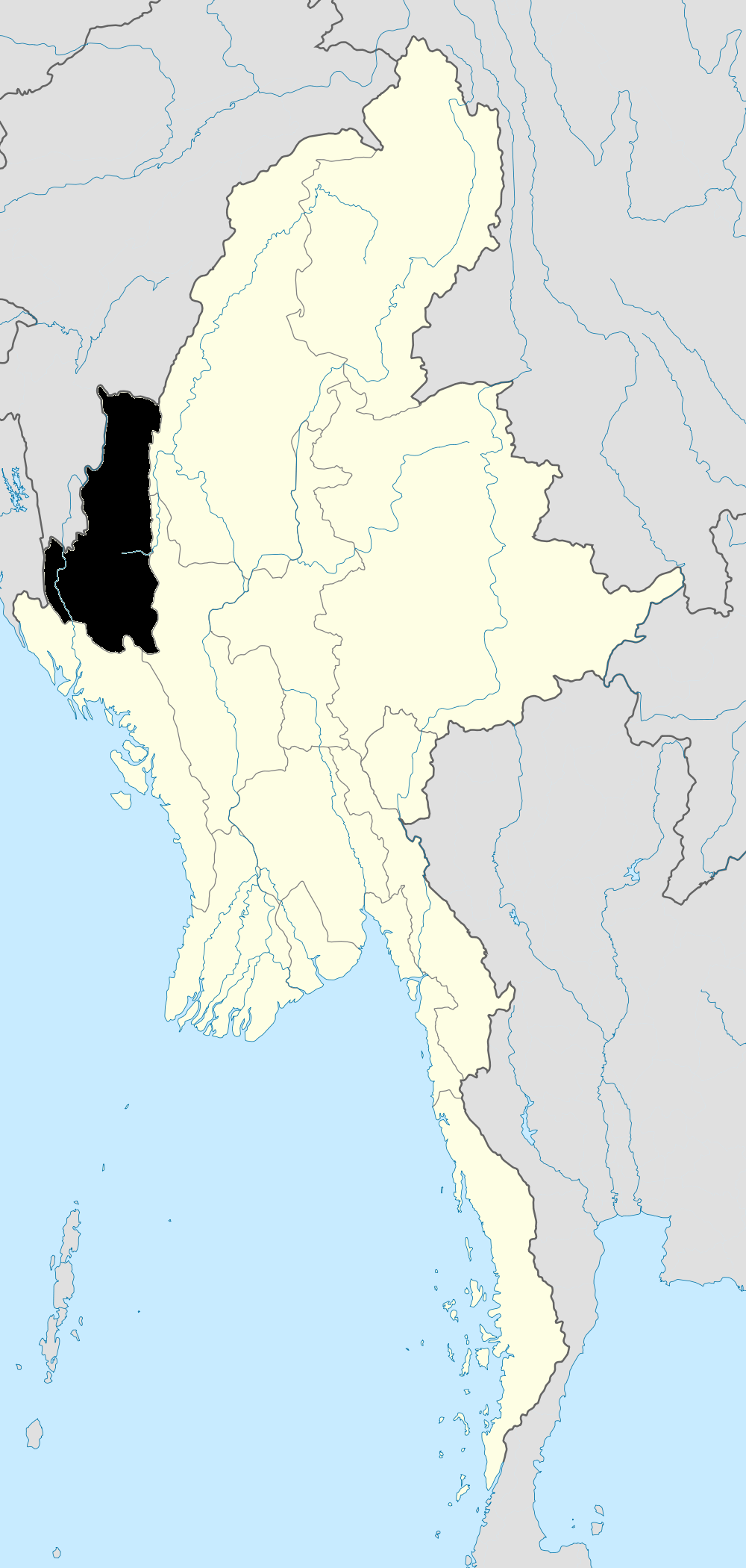
- Chin State
-
Not to be confused with Chinland (Lairam), the Laimi-inhabited areas of Bangladesh, India and Burma (Myanmar).
Chin State
ချင်းပြည်နယ်— State — Myanma transcription(s) – Burmese kyang: pranynai 
FlagLocation of Chin State/Chinland in Burma
Coordinates: 22°0′N 93°30′E / 22°N 93.5°ECoordinates: 22°0′N 93°30′E / 22°N 93.5°E Country  Burma
BurmaRegion Western Burma Capital Hakha Government – Chief Minister Hong Ngai[1] (USDP) Area[2] – Total 36,019 km2 (13,907 sq mi) Population (2000)[2] – Total 480,000 – Density 13.3/km2 (34.5/sq mi) Demographics – Ethnicities Chin – Religions Christianity, Buddhism and Animism Time zone MST (UTC+06:30) Chin State (Burmese: ချင်းပြည်နယ်, pronounced [tɕʰɪ́ɴ pjìnɛ̀]) is a state located in western Burma (Myanmar). The 36,019-square-kilometre (13,907 sq mi) Chin State is bordered by Rakhine State in the south, Bangladesh in south-west, Sagaing Division and Magway Division in the east, Indian state of Manipur in the north and Indian state of Mizoram in the west. The Chin ethnic group make up the majority of the state's 500,000 people.
The capital of the state is Hakha. The state is covered with mountainous region with few transportation links, Chin State is sparsely populated and remains one of the least developed areas of the country.
Contents
History
Early history
The Tibeto-Burman Chin peoples entered the Chin Hills some time in the first millennium AD, as part of the wider migration of Tibeto-Burman peoples into the area. Some historians speculate that the Thet people mentioned in the Burmese Chronicles might be the Chins.[3] For much of history, sparsely populated Chin Hills were ruled by local chiefs. Political organization in the region prior to the Toungoo dynasty's conquest in mid-16th century remains largely conjectural. The first recorded instance of a western kingdom believed to be near the Chin Hills is the Kingdom of Pateikkaya, a tributary to the Pagan Kingdom in the 11th and 12th centuries. Some historians (Arthur Phayre, Tun Nyein) put Pateikkaya in eastern Bengal, thus placing the entire Chin Hills under Pagan suzerainty but others like Harvey, citing stone inscriptions, put it near eastern Chin Hills.[4] (Burmese Chronicles report the kings of Pateikkaya as Indian though the ethnicity of the subjects is not explicitly cited.)
Feudal era
 Bayinnaung's Empire
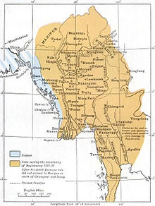
The first confirmed political entity in the region was the Shan State of Kale (Kalay), founded by the Shan people who came to dominate the entire northwestern to eastern arc of Burma after the fall of Pagan Kingdom in 1287. Kale was a minor Shan state, and its authority did not extend more than its immediate surrounding area, no more than a small portion of northern Chin Hills. The minor state occasionally paid tribute to the larger Shan States of Mohnyin and Mogaung, and ultimately became a vassal state of Burmese Ava Kingdom in the 1370s. Starting in the 1480s, Ava began to disintegrate, and Kale was swallowed up by the Shan State of Mohnyin by the 1520s.
The entire Chin Hills came under the authority of Burmese kingdoms between 1555 and 1559 when King Bayinnaung of Toungoo Dynasty conquered all of Upper Burma and its surrounding regions—stretching from the eastern and northern Shan states to the western Chin Hills and Manipur.[5] Toungoo began to weaken in the late 17th century. By the 1730s, a resurgent Manipuri Kingdom had conquered the Kabaw Valley from the Burmese. Kabaw valley's adjacent northern Chin Hills likely came under Manipuri suzerainty.
Burma re-exerted control over the region in the 1750s as King Alaungpaya of Konbaung dynasty conquered Manipur in 1758 and made it a tributary to the Burmese kingdom once more.[6] Konbaung kings conscripted many Chin levies (along with Hkamti Shans) to fight in their wars in Lower Burma, Siam, and Manipur. The Chin Hills were one western region the Burmese retained after the rest of their western possessions—Assam, Manipur, and Arakan—were ceded to the British after the First Anglo-Burmese War of 1824-1826. After the Second Anglo-Burmese War of 1852, the Konbaung throne's authority in the remote regions was largely nominal, with the vassals paying nominal tribute.
Colonial era
The British acquired the Chin Hills a decade after the Third Anglo-Burmese War of 1885. The ensuing Chin resistance to the British was suppressed only by 1896. The British administered the Chin Hills as part of Arakan Division.[7] American missionaries began arriving in the 1890s and by the middle of 20th century, most of the Chin people had converted to Christianity.
The region was the westernmost advance of the Imperial Japanese Army, which occupied the region in November 1943, in World War II. After the war, Chin leaders, along with Burman, Shan and Kachin leaders, participated in the Panglong Conference which discussed the future of an independent Union of Burma. Because of the region's heavy economic dependence on Burma Proper, Chin leaders, unlike Shan and Kachin leaders, asked only for a "special administrative division", not a full fledged state. As a result, when the 1947 Constitution of Burma granted the right of secession to states after a period of ten years after the independence, the Chin did not get a state (no right to secede). (Ironically, the Karen who did not even participate in the conference received a state, along with the right to secede.)
Post independence
Upon independence from the United Kingdom in 1948, Chin Hills Special Division was created out of Arakan Division, with the capital at Falam. On January 4, 1974, it was granted the state status and became Chin State.[7] Today, the state has little infrastructure and remains extremely poor and undeveloped.
Administrative divisions
Chin State consisted of two districts North (now Falam) and South (now Mindat) and was further subdivided into nine townships. Falam had been the state capital since the British Colonization, but after the military coup in 1962, the junta in the 1974 reorganization shifted the state capital to Hakha. The township borders have been adjusted a couple of times, most recently in a reorganization of Falam District in 2008 where Falam Township lost area in its northeast to Tiddim Township, but gained territory from Tiddim in the northwest, extending northward as far as the developing town of Rihkhawdar (Reehkawdar) on the Indian border. In that reorganization Falam also lost a small area in its southwest back to Htlantlang Township from which it had recently been shifted.
Districts and townships
- Falam District of Northern Chin State
- Falam Township
- Hakha Township
- Thantlang Township
- Tedim (Tiddim) Township
- Tonzang Township
- Mindat District of Southern Chin State
Cities
Geography
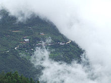 HiangHing Village, Tedim Township - View
Nat Ma Taung (Burmese), Thuamvum (Tedim), (Mount Victoria, English), 10,500 feet (3,200 m) high, is the highest peak in Chin State and the second highest peak in Burma. Many natural watercourses flow among mountain ranges running from north to south forming a number of valleys and gorges. The state has a lot of rivers and the Manipur River flows through its northern half. The Tayawbar River (Tiau River) forms much of the border with India for the northern half of the state. The Boynu River, as the Kaladan River is known upstream from its confluence with the Tayawbar, forms the border with India for the central portion of the state. In the southwestern part of the state, the Kaladan River enters from India and flows down past Paletwa and exits into Rakhine State. The longest water fall in Chin state is the Bungtla Waterfall near Matupi.
Demographics
Chin State has a population of about 518,144 and a population density of 37 persons per square mile on December 12, 2006.[citation needed]
The Chins are made up of many clans, which although historically related now speak divergent languages and have different cultural and historical identities. Some consider the name Chin seems an exonym, given by the Burmese and of unclear origin. These names are justified respectively by the fact that Chin are world known for Loyalty to the Masters and were well-known for their weaving skills and have been in trade relations with the lowlands for many years. The term "Zomi" represents one dialect group who once upon a time live together in a Ciimnuai Area represents Tedim, Tonzang, Kalay, Rih, Haimual, Cikha, Tamu and Lamka people while the term "Laimi" is the most common name for Haka, Thantlang.
Even though there is no common language in Chin State, Zopau @ Zokam is used as main communication languages in the Zomi habitat area whereas Duhlien is used in most parts of Haka and Falam habitat area of the Chin State. As Hakha and Falam dialects are from Dulien dialect and 85% of the phonetic and accent are exactly the same, people from Falam can easily communicate with Hakha language and vice versa.
Chin people are called by different names such as Zomi, Lusei, Kuki,and others based on their own different dialects. Zomi is widely used for their names amongst the known-said Chin like among the Tedim, Tonzang, Cikha, Haimual, Rih, Sagaing Division, Lushai Hills, Manipur and in the lowlands of Burma.
The Chin peoples [Zomi] escaped to Burma and then moved around until they reached the high-lands of the then Zogam, now the 'Chin States', Manipur, Nagaland, Assam (all three in India), Mizoram, Bangladesh, even until the Nepal land (the Gurkha gam). Therefore, though 'Chin' is not included in their word, each tribe of Chin people has its own name, e.g. Zomi, Mizo, These terms could well be cognates, but each has its own pronunciation and sometimes its own meaning. According to the record of Zam Sian Sang, Gualnam who'd surveyed the Seasons and Population of the called Chin (Zomi) Nationalities during the years 2004-2007 with the 'Zogam Survey' Researched team, the Different combination of all Chin peoples and their populations are as follows:
1. In Sagaing Division
- Chin (Lai & Zomi) (427800 + )
- Lai (Haka, Thantlang), Zomi (Tedim, Tonzong)
- Mizo (5000 -/+ )
- Paite (2100 -/+)
- Kuki (5000 -/+ )
- Matupi (3000-/+)
- Asho (40000 -/+ ), they live mostly in the lowlands and mixed with Burmans.
2. In Chin State
- numbered 500,000 in population.
- Plain Chin (340000 + ) all along the Chin States and in India.
3. In India (Census of India 2011)
- Zomi (280000 + )
- Mizo (1000000 -/+ )
- Kuki/zomi (250000 -/+ )
No one can say the exact population of Zomi (Chin) whilst they are dispersing in rush since the past 50 years even. Besides, the number of chin in Chin State has been decreasing at a rapid rate due to migration since early 2000s for economic and political reasons. Economically, making a living is getting much harder due to rapid population increase and unsustainable agricultural practice of Slash and Burn agriculture. Politically, since early 1990s, a large number of Burmese soldiers began moving into Chin State despite the fact that there hasn't been any movement of rebellion. It is estimated that from Falam region alone, approximately 100,000 have moved to other parts of Burma and a significantly large number has gone to neighboring countries of India, Malaysia and Thailand since year 2000. From Hakha and Thantland regions, no less than 100,000 people have migrated to Malaysia, India and other parts of Burma. This phenomenon of emigration of a large number of people is true for other townships in Chin State, with the exception of Mindat, Kanpetlet and Paletwa, three of the most isolated towns in Chin State. Since early 2000, a large number of chins living and working both legally and illegally have been resettled as refugees in third countries including Australia, Norway, Finland, Denmark, Netherland, Canada, United States and New Zealand with the United States taking in the largest numbers of them.
The ethnic Lai Chin use the word 'Salai' indicates 'Mr.' (Mister) and 'Mai' as 'Miss since early 1970s under the leadership of Salai. Tin Maung Oo. Though the Hakha of ethnic Chin use 'Leng' as Miss and 'Val' as Mr. The Tedim (Zomi) ethnic group use 'Tang' as 'Mr' and 'Lia' as 'Miss'. Matu use 'Mang' and 'Tuem' for (Matu woman)and 'Pu' and 'Pi', and 'Pa' and 'Nu', are used commonly for elderly Chin and Chin leaders such as Pu. Hrang Thio (famous for is courageous in the nation wide). The title of 'Pu' is a term of respect, failure to use it where it might be expected may be interpreted as a sign of disrespect. The word 'Pi' is used to address elderly Chin women. Different tribes also practice different ways in naming people.
Owing to missionaries' work over the last hundred years, a great deal of the population now identifies itself as Christian. A sizable minority, however, adheres to Theravada Buddhism and also Animism.
Transport
The Government has been building many new miles of roads in the mountainous region. Earth roads have been upgraded into metalled ones, and the metaled roads to bituminous facilities. The 115-mile (185 km) Kalay-Falam-Haka road is already completed. Bituminous roads include
- 70 miles and four furlong Gangaw-Haka road
- 102 miles Mindat-Matupi road
- 172 miles and seven furlong Haka-Matupi road
- 115 miles and one furlong Kalay-Falam-Haka road
- 53 miles long Haka-Hmandaw road is under construction and almost completed by the donation of Chin (Laimi peoples) communities around the world.
- Kyaukhtu-Mindat road linking Chin State and Magway Division
have been built.ASEAN Highway crosses through the center of Zomi settling areas of Madalay-Kalay-Tamu-Lamka/Behiang The sector wise upgrading of the gateways to Chin State
- Mandalay-Sagaing-Monywa-Gangaw-Haka road
- Pakokku-Pauk-Tabyin-Kyaukhtu-Mindat road
is in progress at present.The Kyaukhtu Airport, built by Directorate of Military Engineers of the Ministry of Defence in Kyaukhtu, Saw Township, Gangaw District, Magway Division, was commissioned into service on July 10, 2004. The airport has helped develop the transport sector of southern Chin State linking Yaw and Pakokku regions in Magway Division. Cars can reach Kanpetlet from Magway (capital of Magway division) via Saw and from Kyautthu and Mindat and Matupi in southern Chin State from Pakukku via Kyaukhtu.
In 1988, the state has two over 180-foot (55 m) bridges:
- 270 foot Natzan Bridge in Tonzang Township
- 240 foot Lemro Bridge in Matupi Township.
The Military Government has built the 340-foot (100 m) Var Bridge across Manipura River on Kalay-Haka Road in Falam Township in 1998 and 480-foot (150 m) 'Mansuang Hlei' Bridge across River Manipura on Tiddim-Kaptel-Rih Lake road in Tiddim District in 2002. The 460-foot (140 m) Manhsaung Bridge is being built across Manipura River on Tiddim-Rih Lake section.
List of bridges in Chin State
- 270-foot (82 m) Naakzang Bridge Narkzang Lei in Tonzang Township
- 240-foot (73 m) Lemro Bridge Lemro Lei in Matupi Township
- 340-foot (100 m) Var Bridge Var Lei in Falam Township
- 480-foot (150 m) Kaptel Bridge Kaptel Lei in Tiddim Township
- 460-foot (140 m) Manhsuang Bridge Mansuang Lei, or Mansuangpi Lei, or Laitui Lei crossing the Manipur River near Laitui
- Vuephu Bridge Vuephu Hlei, Vuephu Due in Zotung(Rezua) Township
- 250-foot (76 m) Boinuva Bridge Biinuv hlei conect to Khuahrang village from Hakha-Matupi Road(Hakha-Matupi lam in Khuahrang khua lei.
Airports
Communication
Development in the communication sector of Chin State
"Comparison between period preceding 1988 and after (up to 31-12-2006)
Subject Count 1988 31-12-2006 Progress Post Office office 29 45 16 Telegraph Office office 11 24 13 computer offices/trainings 1.Vontawi Compute in Sakollam_PaNangSuanGin 2.Will Computer in Lawibual
Facsimile 22 22 Computer telegraph 3 3 Telephone -telephone office office 8 29 21 -telephone line line 3390 4519 1129 -exchange exchange 8 18 10 -direct line line 2431 3402 3159 -auto/manual phone phone 2431 3402 3159 Microwave station station 5 5 Rural telephone exchange exchange 11 11 e-Mail/Internet 12 12 Satellite station -VSAT station 1 1 -MPT satellite Terminal station 15 15 Electricity
The effective utilization of land and water resources in the state has helped develop the power generation capacity of the state.
In 1988, the state has four small scale hydro-power stations
- the Zarlwi in Tiddim Township
- the Daungvar in Haka Towhship
- the Ngasitvar in Falam Township
- the Paletwa in Paletwa Township.
The Military Government has built another 12 diesel power stations and six new hydel power plants, helping increase the power consumption of the state.
The four new hydraulic power plants are
- the 0.2 megawatt Namhlaung Creek plant in Matupi Township
- the 0.6 megawatt Laiva plant in Falam Township
- the 0.2 megawatt Htweehsaung plant in Tonzang Township
- the 0.2 megawatt Chichaung plant in Mindat Township.
The Manipura Multipurpose Dam Project will be implemented in chin State. The Table informs the reader about the development of the state's electricity sector.
Development in the electric power sector of Chin State"Comparison between period preceding 1988 and after (up to 31-12-2006)"
Subject Count 1988 31-12-2006 Progress Electricity consumption unit (in million) 1.552 5.736 4.184 Maximum power megawatt 2.000 2.217 0.217 Installed power megawatt 2.709 5.787 3.078 Extend generating of electricity -Hydel power plant completed Plant 4 10 6 -Small (up to 1 megawatt) Plant 4 10 6 -Diesel used plant Plant 19 31 12 -Private Plant Plant 0 99 99 List of Hydel power plants
- Zalui 0.40 megawatt
- Dongva 0.40 megawatt
- Ngasipva 1.00 megawatt
- Paletwa 0.05 megawatt
- Nanlaungchaung 0.20megawatt
- Laiva 0.60 megawatt
- Htwihsaung 0.20 megawatt
- Chichaung 0.20 megawatt
- Thinthe 0.05 megawatt
- Linebon 0.05 megawatt
Industrial sector
Due to the facilitation of the transport and communication sectors and increase in the power generation in the state, many new private industries have emerged in the region. The state now has 522 private industires, 179 more than 343 in 1988. The number of State owned industries has now reached nine from five in the past. The Government has been striving to develop the industrial sector of the state which will become a major tea-growing region in the future.
"Comparison between period preceding 1988 and after (up to 31-12-2006)"
Subject Count 1988 31-12-2006 Progress Upgrading of industrial power Industry -Private industry industry 343 522 179 -Cottage industry industry 0 2 2 -State owned industry industry 5 9 4 Education
See also: List of universities in Chin StateAccording to official statistics,[8] Chin State had only 25 high schools in 2003. The state does not have any secular colleges or universities. Students have to go outside the state to pursue higher education. The majority attend university in Tahan-Kalay, Sagaing Division. However, there are few private theological colleges in Chin state and they are:
- Chin Christian College (CCC, Haka)
- Union Theological College (UTC, Matupi)
- Zomi Theological College (ZTC, Falam)
- Government Technology of Institute (GTI,Hakha)
- Bethel Bible College (BBC, Tedim)
- Kalay University
- Technological University (Kalay)
- Computer University, Kalay
AY 2002-2003 Primary Middle High Schools 1058 83 25 Teachers 2708 818 333 Students 66,000 30,600 9900 Health care
The general state of health care in Myanmar is poor. The health care infrastructure outside of Yangon and Mandalay is extremely poor. Although health care is nominally free, in reality, patients have to pay for medicine and treatment, even in public clinics and hospitals. Public hospitals lack many of the basic facilities and equipment. The following is a summary of the public health system in the state.[9]
2002–2003 # Hospitals # Beds Specialist hospitals 0 0 General hospitals with specialist services 1 150 General hospitals 9 314 Health clinics 12 192 Total 22 656 References
- ^ "Division and State Administrations". Alternative Asean Network on Burma. 8 July 2011. http://www.altsean.org/Research/Regime%20Watch/Executive/DivisionsStatesAdmins.php. Retrieved 21 August 2011.
- ^ a b "Union of Myanmar". City Population. http://www.citypopulation.de/Myanmar.html. Retrieved 2009-04-10.
- ^ GE Harvey (1925). "Notes on Pateikkaya and Macchagiri". History of Burma. London: Frank Cass & Co. Ltd.. p. 3.
- ^ GE Harvey (1925). "Notes on Pateikkaya and Macchagiri". History of Burma. London: Frank Cass & Co. Ltd.. p. 326.
- ^ Maung Htin Aung (1967). A History of Burma. New York and London: Cambridge University Press. p. 117.
- ^ Lt. Gen. Sir Arthur P. Phayre (1967). History of Burma (2 ed.). London: Susil Gupta. p. 167.
- ^ a b "Myanmar Divisions". Statoids. http://www.statoids.com/umm.html. Retrieved 2009-04-10.
- ^ "Education statistics by level and by State and Division". Myanmar Central Statistical Organization. http://www.etrademyanmar.com/STATS/s1701.htm. Retrieved 2009-04-19.
- ^ "Hospitals and Dispensaries by State and Division". Myanmar Central Statistical Organization. http://www.etrademyanmar.com/STATS/s0413.htm. Retrieved 2009-04-19.
- WorldStatesman- Myanmar- States of Burma 1948-1974
- For more cultural information about the Chin see: F.K. Lehman. 1963. 'The Structure of Chin Society;: A Tribal People of Burma Adapted to a Non-Western Civilization.' University of Illinois Press.

Manipur,  India
IndiaMizoram, India
Sagaing Region
Magway Region Chin State

Chittagong Division,  Bangladesh
Rakhine State - Stavanger Chin Organization
- The Chin National Front
- Chin Human Rights Organization
- Matupi Students Union
- Chin Community in Japan
- Chin Community in Norway
- Chin Community in Denmark
- Chinland Development and Research Society in Sweden
- Chin Community in Germany
- Chin Christian Fellowship in Denmark
- English- Chin Online Dictionary
- MITCS
- ZOGAM Home
- Vaphual news & articles on Zo people
- Chin Community Germany
- The official website of Zomi Reunification Organisation
- Institutes of Higher Education in Myanmar (January 2002) - arranged by state and division
Chin State Capital: HakhaFalam District 

Mindat District Cities and towns Administrative divisions of Burma (Myanmar) States 
Regions Self-Administered Zones Self-Administered Divisions WaUnion Territories Categories:- Chin State
- States of Burma
- Falam District of Northern Chin State


Wikimedia Foundation. 2010.