- Fort Reno (Wyoming)
Infobox nrhp
name = Fort Reno
nrhp_type =
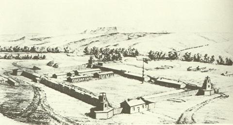
caption = Old Fort Reno
location = E of Sussex on Powder River
nearest_city = Sussex, Wyoming
lat_degrees =
lat_minutes =
lat_seconds =
lat_direction =
long_degrees =
long_minutes =
long_seconds =
long_direction =
area =
built =
architect =
architecture =
added =April 28 ,1970
visitation_num =
visitation_year =
refnum = 70000672
mpsub =
governing_body =Fort Reno (also known as Fort Connor or Old Fort Reno) was a wooden
fort constructed in 1865 by theUnited States Army on theGreat Plains frontier in theDakota Territory in present-dayJohnson County, Wyoming . It served to protect travellers on theBozeman Trail from warring Native American tribes.Establishment
Following the
American Civil War , a large number of settlers headed west to seek new opportunities and land. With the discovery of gold in theBlack Hills region of what is todayMontana , large numbers of miners, adventurers, and settlers flocked to the area, but lacked a direct route to the gold fields. Soon, the Bozeman Trail was constructed through the middle of a region considered sacred by the LakotaSioux , who began to attack travellers along the trail. Concerned, the Army constructed a series of forts and outposts in 1865–66 to house garrisons to deter the Indians.One such fort was established on
August 14 ,1865 , on a highplateau on the banks of the Powder River near the mouth of Dry Fork. It was originally named "Fort Connor" for Brig. Gen. Patrick Connor, whose men of the 6th Michigan Cavalry constructed the fort as a supply depot during thePowder River Expeditions of that summer. OnNovember 11 ,1865 , the post was renamed "Fort Reno" in honor of Maj. Gen.Jesse L. Reno , who had been killed in theAmerican Civil War at theBattle of South Mountain .Fort Reno was crudely built with a quartermaster's and commissary warehouse and stables surrounded by a 120 square foot stockade of 8-10" diameter cottonwood logs. The rough logs were set four feet deep in a trench, leaving a wall about eight feet high. During the fall of 1865, workers constructed other buildings outside of the stockade, including two barracks, two officers' quarters, hospital, shops, teamsters' quarters, and two sutler's buildings. All of the buildings had sod-covered roofs and dirt floors. In August, Companies C and D of the 5th U. S. Volunteers (a command of former Confederate
prisoners of war who had taken theoath of allegiance ), and Company A, Omaha Scouts (members of the Winnebago tribe), relieved the Michigan cavalry. Under the command of Capt. George M. Bailey, they garrisoned the isolated fort during the harsh winter of 1865–66.Reinforcement and abandonment
During
Red Cloud's War the following summer, Col.Henry B. Carrington of the 18th U. S. Infantry led a force of 700 men into the Powder River country to begin construction of two other new posts farther to the north. They reached Fort Reno onJune 28 ,1866 , and stayed two weeks. When he left onJuly 9 , Carrington left behind two companies to replace the existing volunteer garrison, which mustered out of the service and departed home "without a single regret." The newly arrivedRegular Army soldiers constructed a log stockade around the unprotected garrison buildings, complete with log bastions on the northwest and southeast corners. They also built a sturdyadobe commander's quarters. In 1867, the post was renovated and expanded. The garrison (whose number ranged from 125 to a high of 300 soldiers) endured the routines of camp life and the harsh winters and hot summers, occasionally skirmishing with hostile Indians and keeping the southern end of the Bozeman Trail open and passable.The 1868 Treaty of Fort Laramie ended
Red Cloud's War and essentially ceded much of their old hunting grounds to the Lakota. Along with Forts C.F. Smith and Phil Kearny, Fort Reno was abandoned as a condition of the agreement. Shortly after the military left, the entire post was destroyed by fire, possibly ignited byCheyenne warriors. Gen.George Crook 's troops briefly visited Fort Reno in March 1876, but found that all that was left were some adobe walls and building debris. Nevertheless, he used the site as a supply base.Bodies left in the post cemetery were later reinterred and placed at the Custer Battlefield National Cemetery during the 1880s. The grounds that comprised the fort site have generally returned to a natural prairie sod cover.
The site, approximately 12 miles northeast of Sussex, Wyoming, was listed on the
National Register of Historic Places onMarch 28 ,1970 . There is a large stone monument and several interpretive signs marking the site.Two other army posts were also named Fort Reno—one in the defenses of
Washington D.C. during the Civil War, and another frontier outpost built in 1874 in what is nowOklahoma .References and links
* Brown, Dee, "The Fetterman Massacre", University of Nebraska Press, 1971. ISBN 0-8032-5730-9.
* [http://www.philkearny.vcn.com/fortreno.html Fort Phil Kearny Historic Site: Fort Reno]
* [http://wyoshpo.state.wy.us/fortreno.htm Wyoming State Parks & Cultural Resources: Fort Reno]
Wikimedia Foundation. 2010.