- Cabo Rojo, Puerto Rico
Infobox Settlement
settlement_type =
subdivision_type = Country
subdivision_name =United States
subdivision_type1 = Territory
subdivision_name1 =Puerto Rico
subdivision_type2 =
subdivision_name2 =
timezone=AST
utc_offset=-4
timezone_DST=
utc_offset_DST=
unit_pref=Imperial
map_caption =Location of Cabo Rojo, Puerto Rico within Puerto Rico.
latNS=N
longEW=W| official_name = Cabo Rojo, Puerto Rico | nickname = El Pueblo de Cofresí", "Los Mata con Hacha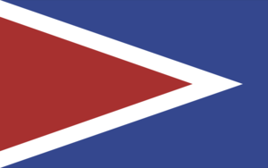
| image_ | population_blank1 = Caborrojeños|population_blank1_title=
| map_caption = Location within the island ofPuerto Rico
established_date = December 17, 1771|established_title=Founded| leader_title =Mayor | leader_title=Mayor
leader_name = Hon. Perza Rodríguez| political party = Partido Nuevo Progresista
leader_party = PNP
leader_title1=Senatorial dist.
leader_name1= 4 - Mayagüez
leader_title2=Representative dist.
leader_name2 = 20| area_magnitude = 1 E9 | area_total_km2 = 459.47
area_land_km2 = 182.21| area_water_km2 = 277.26| population_as_of = 2000 | population_note =
population_total = 46911|population_footnotes= | population_density_km2 = 257.5| timezone = AST | utc_offset = -4 | timezone_DST = | utc_offset_DST = -4| latitude = 18°05'23" N
longitude = 67°09'00" W | website = http://www.ciudadcaborojo.com/| footnotes = Anthem - "Hoy estoy triste por la distancia" |Cabo Rojo (KAH-bo, ro-ho) located on the Western Costal Valley. Bordering the
Caribbean Sea ; and theMona Passage , south of Mayagüez and Hormigueros; and east of Hormigueros, San Germán and Lajas spread over 18 wards and Cabo Rojo Pueblo (The downtown area and the administrative center of the city).It is said that Cabo Rojo obtained its name from the considerable amount of minerals found in its coasts that made the waters look reddish. "Cabo" is the Spanish word for "tip" and analogous to the English word "Cape" in this context. The word "rojo", translates to "red". According to legend, the name was given by
Christopher Columbus himself, although this is highly unlikely. The first church, founded in 1783, was called San José. The present-day main catholic church is called San Miguel Arcángel located in the town's square.People from Combate are known as "mata con hacha" ("those who kill with axes") based on an old folk tale about a fight over the "Salinas" where those from Cabo Rojo fought with axes against people from the adjacent town of Lajas. The latter apparently fought back by throwing stones and are thus known as "tira piedras" ("those who throw stones").
History
Cabo Rojo was founded on December 17, 1771 by Nicolás Ramírez de Arellano and Miguel de Muesas.
Flag
The flag contains elements of the coat of arms, excluding the sword, the anchors and the crown.
Coat of Arms
The point or red triangle symbolizes the "cabo bermejo" (cape bermejo) in Los Morillos. The blue and white, with the anchors, represent the sea that bathes our coasts. The flaming sword, is an attribute to San Miguel de Arcángel, patron of the town. Finally, the crown, which heightens and distinguishes the shield, stands for the status of municipality.
National
protected area *
Cabo Rojo National Wildlife Refuge Demographics
Barrios (Districts/Wards) [http://welcome.topuertorico.org/maps/caborojo.pdf]
Anthem
By Mildred Arroyo
Hoy estoy triste por la distancia
que me separa de mi dulce patria,
y de un pueblito donde mi
padre y mi madre me esperanMi Cabo Rojo pueblo adorado,
jardín de flores te quiero yo
y en la distancia a ti te añoro,
por eso lloro en mi cantar.Son tus palmeras flores divinas
y son tus playas, un manantial
Mi Cabo Rojo, me siento solo
por eso lloro en mi cantar
pero muy pronto besaré tu suelo
o desde el cielo te adoraré.Economic
Tourism
Its tourism industry has flourished with the development of hotels and marinas, but local and international environmentalists are concerned that this development will endanger Cabo Rojo's rich and beautiful beaches,sunsets and natural resources. Cabo Rojo is also well-known for its fishing, particularly the "Puerto Real" fishing village, and its many seafood restaurants, most of which are found in the village of "Joyuda".
Landmarks and places of interest
The famous Cabo Rojo lighthouse,
Los Morrillos Lighthouse , known by locals as "El Faro", was built in 1881 over limestone cliffs that rise 200 feet above sea level. This old lighthouse was automated and electrically charged in 1967 and is considered to have some, if not the, most spectacular ocean views in Puerto Rico's West Coast. The lighthouse has undergone recent renovations, of which has created controversy because of the quality of work. According to locals and scholars, the internal structure was gutted leaving nothing of historical significance behind.The lighthouse is located near the "Salinas", or
salt mine s. These salt mines are reported to be the oldest industry in theNew World . Salt has been mined in this site non-stop since the times of theTaínos . Near the "Salinas", a local civic group "Caborrojeños Pro Salud y Ambiente " run a visitor's center known as the "Centro Intepretativo Las Salinas De Cabo Rojo donEfrén Pérez Rivera ". They offer free guided tours of the local area, which is rich in flora and fauna.In 2006, Cabo Rojo was specifically chosen by the Latin Grammy-winning Puerto Rican group Calle 13 as the setting for their video "La Jirafa" because of its beautiful natural scenery.
*Boquerón Beach
*Cofresí Cave
*El Combate Beach
*Joyuda Beach
*Joyuda Lagoon
*Market Plaza
*Nautical Club
*Punta Arenas Beach
*Punta Real Beach
*Isla de Ratones
*Buye Beach
*The Lighthouse (El Faro) BeachFestivals and events
*Pescao Festival - March
*Años Cuarenta Festival - April
*Chigüero Festival - April
*Betances Festival - April
*Oyster Festival - May
*Boquerón Bay Crossing - July
*Watermelon Festival - July
*Retorno a la Arena - July
*Patron Festivities - September
*La Pileta Festival - December
*Le Lo Lai Festival - DecemberTransportation
Although Cabo Rojo lacks an
airport , it is approximately 11 miles from theEugenio Maria de Hostos Airport (MAZ), a commercial airport that serves direct flights to and from San Juan. Cabo Rojo has grown tremendously in the last few years as evidenced by its recent accreditation as acity . Cabo Rojo nearest airport servicing international destinations is only 45 minutes away in the Aguadilla'sRafael Hernandez Airport (BQN). This airport was part of the now deactivated Ramey Air Force Base.ports
Cabo Rojo had a BSN
basketball team, "Los Turistas de Cabo Rojo" (the "Cabo Rojo Tourists") from1989 to1993 .Notable "Caborrojeños"
Some "caborrojeños" who have distinguished themselves are:
Eziah M. González Ramos ,Mildred Arroyo,Ramón Emeterio Betances ,Carlos Betances Ramírez ,Salvador Brau , pirateRoberto Cofresí ,Rebekah Colberg ,Ramón López Irizarry ,Tommy Muñiz andBartolomé Javier Petrovich .Cabo Rojo's former mayor, Santos "El Negro" Ortiz, made history in
1988 by becoming the first public servant to be elected into office without being affiliated with one of Puerto Rico's major political parties.Another of Cabo Rojo's former mayors, Santos Padilla, was affiliated with Puerto Rico's pro-statehood party. Puerto Rico's former (and first female Governor)
Sila Calderon , a San Juan native, was a member of the pro-status-quo party. Both Padilla and Calderon are credited with Cabo Rojo's recent development and growth spurt.Santos Padilla, Cabo Rojo's mayor, suffered a massive heart attack and died Aug 4, 2007.
Emiliano Mercado del Toro , who was for a time the world's oldest living man and oldest veteran, was born in Cabo Rojo onAugust 21 ,1891 .Other notable "caborrojeño" is
Mary Ann Acevedo , a singer and songwriter, participant of the reallity show Objetivo Fama.References
External links
* [http://factfinder.census.gov/servlet/GCTTable?_bm=y&-geo_id=05000US72023&-_box_head_nbr=GCT-PH1&-ds_name=DEC_2000_SF1_U&-redoLog=false&-format=CO-2&-mt_name=DEC_2000_SF1_U_GCTPH1_ST7 Cabo Rojo and its barrios, United States Census Bureau]
* [http://www.caborojopr.com/ Cabo Rojo Puerto Rico]
* [http://www.puertohost.com/maps/cabo-rojo-map.php Map of Cabo Rojo Puerto Rico]
* [http://www.nps.gov/history/nr/travel/prvi/ Historic Places in Puerto Rico and the Virgin Islands, a National Park Service Discover Our Shared Heritage Travel Itinerary]


Wikimedia Foundation. 2010.