- Otago Peninsula
-
 Otago Peninsula
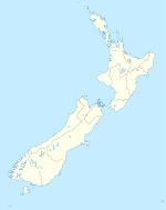
The Otago Peninsula is a long, hilly indented finger of land that forms the easternmost part of Dunedin, New Zealand. Volcanic in origin, it forms one wall of the eroded valley that now forms Otago Harbour. The peninsula lies south-east of Otago Harbour and runs parallel to the mainland for 20 km, with a maximum width of 9 km. It is joined to the mainland at the south-west end by a narrow isthmus about 1.5 km wide.
The suburbs of Dunedin encroach onto the western end of the peninsula, and seven townships and communities lie along the harbourside shore. The majority of the land is sparsely populated and occupied by steep open pasture. The peninsula is home to many species of wildlife, notably seabirds, pinnipeds, and penguins, and several ecotourism businesses operate in the area.
Contents
Geography
 NASA satellite photo of Otago Peninsula and Otago Harbour. The city of Dunedin is located at the isthmus at lower left.
The peninsula was formed at the same time as the hills that face it across the harbour, as part of a large, long-extinct, volcano. Several of the peninsula's peaks, notably the aptly named Harbour Cone, clearly show these volcanic origins in their form. These rocks were built up between 13 and 10 million years ago.
Much of the peninsula is steep hill country, with the highest points being Mount Charles (408 m), Harbour Cone, and Sandymount. Two tidal inlets lie on the Pacific coast of the peninsula, Hoopers Inlet and Papanui Inlet. Between them is the headland of Cape Saunders. Nearby natural features include the 250-m-high cliffs of Lovers' Leap and The Chasm.
At the entrance to the Otago Harbour the peninsula rises to Taiaroa Head, home to a breeding colony of Northern Royal Albatross, the only colony of albatross to be found on an inhabited mainland. The viewing centre for the albatross colony is one of the peninsula's main ecotourism attractions, along with other wildlife such as seals and Yellow-eyed Penguins. Most of the Otago Peninsula is freehold farming land, with increasing numbers of small holdings or lifestyle blocks. Some biodiversity sites such as Taiaroa Head are managed as sanctuaries for wildlife. Many species of seabirds and waders in particular may be found around the tidal inlets, including spoonbills, plovers, and herons.
 Black-winged Stilt on the peninsula
The Pacific coast of the peninsula includes several beaches that are far enough removed from Dunedin to be sparsely populated even in mid-summer. These include Allan's Beach, Boulder Beach, Victory Beach, and Sandfly Bay.
Victory Beach, named after the 19th century shipwreck of the Victory close to this coast, features a rock formation known locally as "The Pyramids" for its resemblance to the ancient Egyptian monuments. Sandfly Bay, named not for the insect but for the sand blown up by the wind, is reached via a path through some of New Zealand's tallest sand dunes, which rise for some 100 metres above the beach.
Other tourist attractions on the peninsula include Larnach Castle, a restored Armstrong 'disappearing' gun coastal defence post, and a war memorial cairn. There are views of the city and surrounding country from Highcliff Road, which runs along the spine of the peninsula.
The total population of the peninsula is under 10,000, with about half of these in the suburbs of Dunedin that encroach onto its western end, such as Vauxhall and Shiel Hill. For much of its length, only the strip adjacent to the Otago Harbour is populated, with several small communities dotting its length. Largest of these are Macandrew Bay (the peninsula's largest settlement, with a population of 1,100), Portobello, and Otakou, which was the site of the first permanent European settlement on the Harbour, and the site of an early whaling station, commemorated at nearby Weller's Rock.
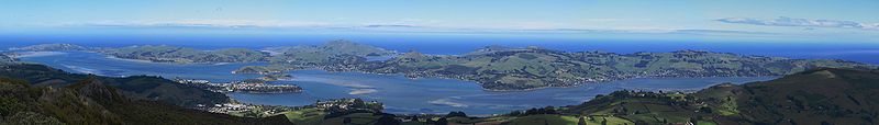 Panorama of Otago Peninsula from Mt. Cargill, looking southeast across Otago Harbour. On the extreme left are the harbour mouth, Aramoana and Taiaroa Head. Near the centre is Harbour Cone, and below it Broad Bay. Portobello and Macandrew Bay are to the left and right respectively. Quarantine Island/Kamau Taurua is mid left above Port Chalmers.
History
Pre-European settlement
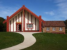 Otakou marae whare runanga
Modern archaeological opinion favours a date for New Zealand's first human settlement around 1100 AD with people concentrated on the east coast of the South Island. In Archaic (or moa hunter) times the Otago Peninsula was a relatively densely occupied area at the centre of the country's most populous region.
A map of recorded Māori archaeological sites for the Otago Conservancy shows many more on the Otago Peninsula than elsewhere in the region.[1] Another showing only those of the Archaic period shows sites clustered on the peninsula and along the coast across the harbour to the west and north.[2] This was one of three more or less distinct clusters on the South Island's south east coast: one from about Oamaru south to Pleasant River; another from Waikouaiti south, which includes the Otago Peninsula and tails off about the Kaikorai estuary; another extending south from the Clutha mouth. The clusters contain a few larger sites. On the Otago Peninsula the one at Little Papanui is of middle size while that at Harwood Township is one of the largest. These and numerous other smaller sites are clearly visible, though often not recognised by visitors for what they are.
Their occupants were people of Polynesian culture and descent, ancestral to modern Maori, who lived by hunting large birds, notably the now extinct flightless moa, but also seals and by fishing.
Whale ivory chevron pendants found at Little Papanui were made by the site's early occupants and are now in the Otago Museum, Dunedin. The site's lowest levels have been estimated to have been occupied some time between 1150 and 1300 A.D. Another peninsula site, at Papanui Inlet, is thought to have been occupied in the same period, as was the extensive one at Harwood Township.[3] Little Papanui and Harwood are considered to have been permanent settlements, not temporary camps. A single radiocarbon date for Harwood suggests it was also occupied in 1450.[4] Three magnificent greenstone adzes, said by H.D. Skinner to be the finest of their type, were found nearby and are dated to the same time. They represent a form already archaic when they were made. They are in the Otago Museum.
Southern Māori oral tradition tells of five successively arriving peoples and while the earliest, Kahui Tipua, appear to be fairy folk modern anthropological opinion is that nevertheless they represent historical people who have become encrusted with legend.[5][6] Te Rapuwai were next and seemed to be succeeded by two Waitaha tribes but it has been suggested this was really one with 'Waitaha' also being used as a catchall name for all earlier peoples by some later arrivals. 'Te Rapuwai' may perhaps also have been used like this.[5] Nevertheless some middens, such as those on the peninsula, have been identified traditionally with Te Rapuwai. Anderson's later, or tribal Waitaha, arrived in the south in the 15th century.
Moa and moa hunters went into decline but a new Classic Māori culture evolved, characterised by the construction of pa, fortified villages, and new peoples arrived on the Otago Peninsula. People here at this time practised what has been called a foraging economy. Increasing reliance seems to have been placed on harvesting the root of the cabbage tree (cordylline australis) and 'umu ti', cabbage tree ovens, proliferate over some parts of the Peninsula showing intensive use of the land.
Kati Mamoe (Ngāti Mamoe in modern standard Māori) arrived in the late 16th century. Kai Tahu (Ngāi Tahu in modern standard Māori) came about a hundred years later. Pukekura, a fortress on Taiaroa Head, was built about 1650. Nearby villages on Te Rauone Beach perhaps date from the same time. Pukekura's terraces are still visible some of them co-opted into later European defence works.
Many traditions survive from this period concerning figures such as Waitai and Moki II who at different times both lived at Pukekura pa. One of the best known concerns Tarewai who is difficult to place chronologically but was of Kai Tahu descent. He gained possession of Pukekura, was in conflict with Kati Mamoe at Papanui Inlet and made a famous escape back into Pukekura by a cliff still known as Tarewai's Leap. There had been an argument about Kati Mamoe fishing rights on Papanui Inlet. A particularly fine, talismanic, whale bone fishook of the 18th century was found there and is now in the Otago Museum.
The arrival of the Europeans
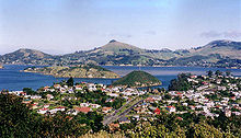 Looking across Port Chalmers and Otago Harbour towards the Otago Peninsula, Harbour Cone at top centre
James Cook was off the coast in February 1770 and named Cape Saunders after the Secretary of the Admiralty. His chart showed a bay at what is Hooper's Inlet, which may have been explored and named by Charles Hooper chief officer on Daniel Cooper's English sealer, Unity, in the summer of 1808-9. Sealers used the harbour from about this time, probably anchoring off Wellers' Rock, modern Otakou, where there was an extensive Māori settlement or settlements. The Sealers' War (also known as the War of the Shirt) was sparked by an incident on the Sydney Cove in Otago Harbour late in 1810 while her men were sealing at Cape Saunders. This incidentally produced James Kelly's attack on 'the City of Otago', probably the Te Rauone settlement(s) in December 1817 after William Tucker and others had been killed at Whareakeake (Murdering Beach) a few miles north. Peace was re-established by 1823. 1826 saw the visit of the Rosanna and the Lambton, ships of the first New Zealand Company bringing the first recorded European women and producing Thomas Shepherd's pictures of the Peninsula, the oldest now known, held in the Mitchell Library Sydney. In November 1831 the Weller brothers, Joseph, George and Edward, established their whaling station at Wellers Rock.
In the course of a turbulent decade the Wellers' Otago establishment grew to be the largest in the country and the harbour became an international whaling port. European women were present at the station from the beginning. There was conflict with Māori who suffered epidemics of measles and influenza in 1835 and 1836. Whaling collapsed in 1839 and Dumont D'Urville, a visiting French navigator, described the Peninsula's European and Māori communities both trafficking in alcohol and sex, in March 1840. The Treaty of Waitangi was signed on the Peninsula in June, although the South Island had already been annexed by 'right of discovery'. The first Christian service was preached on the Peninsula later that year at Otago by Bishop Pompallier. In 1841 Octavius Harwood and C.W. Schultze took over the Wellers' operation.
Various European visitors in the 1840s made records. In 1844 Māori reserved the land at the Heads when they sold the Otago Block to the Otago Association for its Scottish Free Church settlement. Charles Kettle, the Association's surveyor, laid out suburban and country blocks in 1846-7. The arrival of the first migrant ships in early 1848 saw the focus of settlement move to Dunedin while Port Chalmers on the other side of the harbour succeeded Otago as the international port. In December William Cargill, secular leader of the Otago settlement, successfully petitioned the government to re-instate 'Otago' as its original name. The old whaling village and adjacent Māori settlements had now become 'Otakou'.[7]
The growth of modern settlement
As Dunedin developed the Peninsula's southern end became a city recreation ground and then a suburb. Native bush was cleared over most of the terrain in a massive transformation of the landscape. Settlements were formed on the harbourside and on the Highcliff Road on the spine of the land mass, but in the early phase of European settlement, also on the more exposed Pacific slopes.
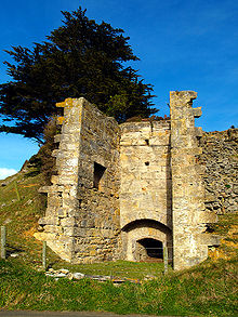 Peninsula lime kiln
During the Otago Gold Rush in the 1860s pleasure gardens were established at Vauxhall; George Grey Russell built his house at Glenfalloch and William Larnach acquired the land for his big house at Pukehiki, 'Larnach Castle'.[8] A lighthouse was built at Taiaroa Head in 1864 and work began using prison labour, sometimes including Maori prisoners of war, to build the winding harbourside road, with its distinctive seawalls of the local stone. Across the cleared land settlers built dry stone walls, following the pattern of 'Galloway Dykes', another conspicuous and distinctive feature of the landscape whose only other examples in New Zealand are across the harbour on the opposite heights. Stone lime kilns were built near Sandymount in 1864.
The land was used for mixed farming and later focused on dairying. This produced New Zealand's first dairy co-operative, at Springfield on the Highcliff Road, in 1871. The peninsula was made a county in 1876, the administrative centre being Portobello. In the 1880s, following fears of a Russian invasion, Taiaroa Head was extensively fortified. An Armstrong Disappearing gun was installed in 1886. Ferries linked the peninsula's harbour coast with the city and Port Chalmers.
In 1904 a marine fish hatchery was established at Aquarium Point, Portobello. Another sign of changing attitudes to wild life was the self-establishment of the Royal Albatross colony at Taiaroa Head in the 1920s which was now carefully nurtured for its scientific interest.
The 20th century saw land use change as the draining and development of the Taieri Plain eventually led to that area eclipsing the Peninsula's dairying and mixed farms gave way to extensive grazing. The rural population, especially on the Pacific coast, dwindled, leaving abandoned steadings and roads decaying slowly behind macrocarpa and hawthorn plantings. The re-made, Europeanised landscape now took on an air of mellow decay, and started to look 'natural', unusual in a recently colonised country like New Zealand. This attracted the attention of visitors and artists. Colin McCahon, New Zealand's most celebrated painter, first worked out his 'vision' of the New Zealand landscape with studies of the peninsula, the most developed being that of 1946-49 now owned by the city and on display in the central Dunedin Public Library.
Radio masts appeared at Highcliff and rural depopulation was compensated by the growth of the harbourside settlements. Improving roads saw the demise of the ferries. After World War 2 the Taiaroa Head garrison was withdrawn and the lighthouse automated. The University of Otago took over the hatchery as a research facility as its commercial purpose waned. The City of Dunedin absorbed Peninsula County in 1967, promising to extend water and sewerage reticulation.
In recent decades there has been growing suburban occupation of the townships, some 'lifestyle' developments on the harbour slopes and an increasing tourist traffic.
The Otago Peninsula is one of the few places in New Zealand where there is everywhere visible evidence of the long human occupation of the land. In a magnificent but compact setting the challenge is to maintain its balance of human and natural in the face of growing residential and tourist development.
Natural history
There is a diverse flora and fauna on the Otago Peninsula. Avafauna observed include the endangered Yellow-eyed Penguin, Megadyptes antipodes,[9] Little Blue Penguin, shags, Jewelled Geckos and the Royal Albatross. Seal and sea lion colonies have regenerated during the 20th century. A number of New Zealand Fur Seals and Hooker's Sea Lions currently breed around Taiaroa Head. Southern Elephant Seals and Leopard Seals are also known to occur.[citation needed]
In 1975 a whale was seen in Otago Harbour for the first time since the whaling days and the number of sighting of larger whales in this area is increasing. Southern Right Whales are the most frequent of all large cetaceans in the area, followed by Humpback Whale.[10] In addition, two Blue Whales were sighted just offshore from Taiaroa Head in March 2008.[11] Minke Whales also visit the area.[12] Several species of dolphins or small whales also occur constantly around the peninsula: Dusky Dolphin, Bottlenose Dolphin, Common Dolphin, and endangered Hector's Dolphin. Orca, the Killer Whale are occasionally seen. Sperm Whales and some species of beaked whales can be found further offshore and rarely stranded.
Tourist attractions
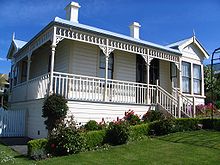 Fletcher House in Broad Bay
- Fletcher House, an Edwardian cottage museum, Broad Bay.
- Otago Peninsula Museum & Historical Society Museum, Peninsula social and agricultural history, Portobello.
- Otago University Marine Aquarium, Aquarium Point, Portobello.
- Larnach Castle
Notes
- ^ (Hamel 2001) fig. 1
- ^ (Hamel 2001) fig. 2
- ^ (Anderson 1983, p. 7)
- ^ (Entwisle 1976, p. 8)
- ^ a b (Anderson 1993, p. 7)
- ^ (Anderson 1998, p. 13)
- ^ (Entwisle 1998, p. 137)
- ^ (Knight 1978, p. 51 & 53)
- ^ (C. Michael Hogan 2009 p.1)
- ^ Benson, Nigel (29 April 2009). "Beholding bounty, beauty and a beast". Otago Daily Times. http://www.odt.co.nz/news/dunedin/53327/beholding-bounty-beauty-and-a-beast. Retrieved 1 November 2011.
- ^ http://www.wildlife.co.nz/galleries/G14_Newsletter-24_4_08.html
- ^ Rudd, Allison (20 October 2008). "Dwarf minke pays a surprise visit". Otago Daily Times. http://www.odt.co.nz/news/dunedin/28100/dwarf-minke-pays-a-surprise-visit. Retrieved 1 November 2011.
References
- Anderson, Atholl (1983), When All the Moa-Ovens Grew Cold : nine centuries of changing fortune for the southern Maori, Dunedin, NZ: Otago Heritage Books
- Anderson, Atholl; Allingham, Brian; Smith, Ian W G (1996), Shag River Mouth : the archaeology of an early southern Maori village, Canberra, Australia: Australian National University, ISBN 0-7315-0342-1, OCLC 34751263
- Anderson, Atholl (1998), The Welcome of Strangers : an ethnohistory of southern Maori A.D. 1650-1850, Dunedin, NZ: University of Otago Press with Dunedin City Council, ISBN 1-877133-41-8 pb
- Dann, Christine; Peat, Neville (1989), Dunedin, North and South Otago, Wellington: GP Books, ISBN 0-477-01438-0
- Entwisle, Peter (1976), The Otago Peninsula, Dunedin: John McIndoe, ISBN 0-908565-23-2
- Entwisle, Peter (1998), Behold the Moon, the European Occupation of the Dunedin District 1770-1848, Dunedin, NZ: Port Daniel Press., ISBN 0-473-05591-0
- Hamel, J (2001), The Archaeology of Otago, Wellington, NZ: Department of Conservation, ISBN 0-478-22016-2
- Hogan, C. Michael (2009), N. Stromberg, ed., Yellow-eyed Penguin: Megadyptes antipodes, GlobalTwitcher.com, http://globaltwitcher.auderis.se/artspec_information.asp?thingid=222
- Knight, Hardwicke (1978), Otago Peninsula : a local history, Broad Bay, NZ: Hardwicke Knight
External links
 Media related to Otago Peninsula at Wikimedia CommonsCategories:
- Otago Peninsula
- Volcanoes of New Zealand
- Visitor attractions in Dunedin


Wikimedia Foundation. 2010.