- Military Demarcation Line
-
Military Demarcation Line Hangul 군사분계선 / 휴전선 Hanja 軍事分界線 / 休戰線 Revised Romanization Gunsabungyeseon / Hyujeonseon McCune–Reischauer Kunsabungyesŏn / Hyujŏnsŏn The Military Demarcation Line (MDL), sometimes referred to as the Armistice Line, is the land border or demarcation line between North Korea and South Korea. On either side of the line is the Korean Demilitarized Zone (DMZ). The MDL and DMZ were established by the Armistice at the end of Korean War in 1953.[1]
In the Yellow Sea, the two Koreas are divided by a de facto maritime "military demarcation line" and maritime boundary called the Northern Limit Line (NLL) drawn by the United Nations Command in 1953.[2] The NLL is not described by the Korean Armistice Agreement.[3]
Contents
Demarcation on land
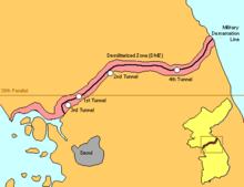 The Military Demarcation Line within the Demilitarized Zone
 MDL sign
 MDL sign in context
The DMZ runs near the 38th parallel, covering roughly 248 kilometers.[4] American and South Korean soldiers patrol this line along the South Korean side while North Korean soldiers patrol along the North Korean side.
In Korean, the line is called the Hyujeonseon (휴전선), meaning "armistice line."[5] It is also sometimes called the Gunsa Bungye-seon (군사분계선), which literally means "military demarcation line." However, in colloquial usage, the dividing line is more often called the Sampalseon (삼팔선, "38th parallel"), a name likely coined at the end of World War II, when it would have been an accurate description of the North-South border.
The line itself is marked off by a series of 1,292 identical signs which are placed at intervals across the peninsula. The north facing side of the signs are written in Chosongul and Chinese, and in Hangul and English on the south facing side. The signs are aging and rusting.
Military incidents
There have been frequent skirmishes along the line since the armistice ended the fighting of the Korean War.
Usage and conventional misuse
The Korean Armistice Agreement is the primary source which defines the MDL; and 21st century scholarly/academic secondary sources continue to recognize this as fundamental.[6] The Armistice is monitored by members of the Neutral Nations Supervisory Commission composed of members from the Swiss[7] and Swedish[8] Armed Forces.
Military Demarcation Line is a de jure term and MDL is an explicit acronym which remain valid today because no mutually acceptable changes have been made. The use of the term or acronym or line which is not explicitly mentioned in the 1953 KAA is not verifiable within the ambit of the primary source text.[9]
The unresolved aftermath of the Korean War has revealed unique, region-specific facets of this conflict.[10] Although the Korean Armistice Agreement specifies where the demarcation line and demilitarized zone are located on land, the agreement does not mention lines or zones in adjacent ocean waters.[11]
Historical context
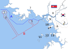 The disputed maritime border between North and South Korea in the Yellow Sea:[12]
A: United Nations Command-created Northern Limit Line, 1953[13]
B: North Korea-declared "Inter-Korean MDL", 1999[14] The locations of specific islands are reflected in the configuration of each maritime boundary, including
Other map features4-Jung-gu (Incheon Intl. Airport), 5-Seoul, 6-Incheon, 7-Haeju, 8-Kaesong, 9-Ganghwa County, 10-Bukdo Myeon, 11-Deokjeokdo, 12-Jawol Myeon, 13-Yeongheung MyeonMain article: Northern Limit LineMain article: Korean maritime border incidentsShortly after the signing of the Armistice, a line in the sea was drawn unilaterally by the United Nations Command (UNC).[15] The contrived Northern Limit Line or North Limit Line (NLL) represents the northern limit of the area in which South Korean vessels may navigate, not a demarcation line on which the two Koreas agreed.[16] The Korean Armistice Agreement (KAA) provisions regarding the MDL and DMZ do not extend into the Yellow Sea or Sea of Japan.[17]
In 1999, North Korea unilaterally asserted its own "North Korean Military Demarcation Line in the West Sea (Yellow Sea)",[18] also called the "Inter-Korean MDL in the Yellow Sea".[19]
The 1953 MDL is a demarcation line, and the 1953 NLL is a demarcation line as well; however, the MDL is a different line than the NLL. The 1999 North Korean MDL is also distinct. Across a span of decades, precision has been blurred by conventional usage and reports in the popular press.[20]
Maritime demarcation
Some now construe the existence of a de facto or "practical" extension of the 1953 MDL.[21]
After more than fifty years, the South Koreans have come to construe a de-facto western inter-Korean border[22] which has remained unchanged since 1953.[23] The map at the right shows that the ambits of the NLL and North Korea's maritime MDL represent overlapping jurisdictional claims.[24] The DPRK rejected the NLL and only recognized the demarcation line it drew in 1999, which was further south of the NLL.[22]
See also
- List of Korea-related topics
- Aftermath of the Korean War
- Military of North Korea
- Military of South Korea
- Division of Korea
- Geography of North Korea
- Geography of South Korea
- Panmunjom
- Camp Bonifas
Notes
- ^ The MDL was defined and established in the Korean Armistice Agreement (KAA), Article I, paragraphs 1–11. The KAA includes provisions regarding the MDL and DMZ; but those provisions do not extend into the Yellow Sea or the Sea of Japan. The subsequently devised Northern Boundary Line or NLL was not initially conceived as part of the MDL. Nor have the DPRK and UNC agreed to any subsequent extension of the MDL beyond the agreed upon limits of 1953/7/27.
- ^ Ryoo, Moo Bong. (2009). "The Korean Armistice and the Islands," p. 5. Strategy research project at the U.S. Army War College; excerpt, "Strategic Consequences of the Agreement. The agreement to retain the five islands under UNC control has shaped many aspects of the security environment of the Korean Peninsula. The most obvious and prominent consequence is the establishment of the Northern Limit Line (NLL). The NLL has served as a practical maritime borderline and an effective means to separate the forces and thus prevent military clashes between th two Koreas"; compare Kim, Kwang-Tae. "After Exchange of Fire, N. Korea Threatens More Strikes on South," Time (US). November 23, 2010.
- ^ Pak, Hŭi-gwŏn. (2000). The Law of the Sea and Northeast Asia: a Challenge for Cooperation, p. 108 at Google Books; excerpt, "Under the 1953 Armistice Agreement, the Military Demarcation Line was drawn across the Korean peninsula. Since no maritime demarcation line was specified in the Armistice Agreement, however, the United Nations Command drew the NLL...."
- ^ "Korean War History". http://www.lifeinkorea.com/culture/dmz/dmz.cfm?Subject=History2. Retrieved 2006-01-12.
- ^ See, e.g., Dictionary – Definition of armistice.
- ^ Compare, e.g., Van Dyke, Jon M., Mark J. Valencia and Jenny Miller Garmendia. "The North/South Korea Boundary Dispute in the Yellow (West) Sea," . Marine Policy 27 (2003), 143–158.
- ^ Swiss Armed Forces "NNSC in Korea" 2011
- ^ Swedish Armed Forces "NNSC – Korea
- ^ Compare, e.g., map in New York Times (US),
- ^ Clark, Gregory. "The N. Korea conundrum," Japan Times. December 1, 2010.
- ^ Glionna, John M. "Sea border a trigger for Korean peninsula tension," Los Angeles Times (US). January 6, 2011; retrieved 2011-07-28
- ^ Ryoo, p. 13.
- ^ "Factbox: What is the Korean Northern Limit Line?" Reuters (UK). November 23, 2010; retrieved 26 Nov 2010.
- ^ Van Dyke, Jon et al. "The North/South Korea Boundary Dispute in the Yellow (West) Sea," Marine Policy 27 (2003), 143–158; note that "Inter-Korean MDL" is cited because it comes from an academic source and the writers were particular enough to include in quotes as we present it. The broader point is that the maritime demarcation line here is NOT a formal extension of the Military Demarcation Line; compare "NLL—Controversial Sea Border Between S.Korea, DPRK, " People's Daily (PRC), November 21, 2002; retrieved 22 Dec 2010
- ^ Kim Young-koo. "A Maritime Demarcation Dispute on the Yellow Sea: Republic of Korea," Journal of East Asia and International Law (JEAIL), Volume 2, Number 2.
- ^ "Modern meaning of Korea’s maritime line," The Hankyoreh (ROK). October 15, 2007.
- ^ In principle, the UNC and PRK could agree to extend the MDL into the Yellow Sea (IAW para. 62 of the KAA); however, there is no such agreement.
- ^ Zou, Keyuan. (2005). Law of the Sea in East Asia: Issues and Prospects, p. 7 at Google Books; excerpt, "In response to the unilateral NLL, the North Korean authorities declared after the 1999 incident (on 2 September 1999), that they had set up a 'North Korean Military Demarcation Line in the West Sea (Yellow Sea)' which overlaps with the existing NLL"; Lee, Hy-Sang Lee. (2001). North Korea: a Strange Socialist Fortress, p. 191 at Google Books; "South Korea is a criminal without principle." – Noth Korea", Sir Lanka Guardian, November 25, 2010.
- ^ "NLL—Controversial Sea Border Between S.Korea, DPRK, " People's Daily (PRC), 2002-11-21; retrieved 2010-11-26.
- ^ "Two Killed In Sea Crash," St. Joseph Gazette (US). December 24, 1962; excerpt, "The gunboats clashed near Island in the Yellow Sea just south of the military demarcation line, the South Korean announcement said"; "Ships Trade Fire I With Reds," News And Courier (US). May 28, 1967; excerpt, "The shelling occurred near the military demarcation line separating North and South Korea. A ROK spokesman said that ships were in the area to protect fishing boats"; "Red Korea Seizes Boat, 20 Crewmen," Free Lance-Star (US). June 5, 1970; excerpt, "The general area is near the seaward extension of the military demarcation line that separates South Korea from the Communist North"; "In Korean Flareup," Miami News (US). February 27, 1975; excerpt, "... North Korean vessels found cruising about 20 miles south of the extension of the military demarcation line between the two Koreas"; "North Korea Returns 12 South Koreans," Toledo Blade (US). October 20, 1985; excerpt, "... fishing in international waters waters about 40 miles west of the South Korean island of Paeknyong-do near the western sea extension of the military demarcation line dividing the Koreas"
- ^ Ryoo, p. 11; excerpt, "The NLL has served as an effective means of preventing military tension between North and South Korean military forces for 46 years. It serves as a practical demarcation line, which has contributed to the separation of forces." --1999. 6. 11, United Nations Command (Korea); Aigner, Erin and Haeoun Park. "Military Strike in the Waters Between North and South Korea," New York Times. November 23, 2010; Williams, David and Peter Simpson. "Korea on the brink: South warns of retaliation after North's shellfire strike kills two marines," Daily Mail (UK). November 24, 2010; retrieve 22 Dec 2010.
- ^ a b "DPRK declares five more no sail zones off coast," China Daily (PRC). January 2, 2010; excerpt, "NLL was fixed unilaterally by the US-led United Nations Command after the 1950–1953 Korean War. South Korea holds the NLL as the de-facto western inter-Korean border, but the DPRK rejected the NLL and only recognized the demarcation line it drew in 1999, which was further south of the NLL."
- ^ Ryoo, p. 10; excerpt, The UNC stated in August 1999: "... the NLL issue was nonnegotiable, because the demarcation line had been recognized as the de facto maritime border for many years by both Koreas."
- ^ Van Dyke (2003) 143–158, 144; excerpt, "North Korean MDL declaration", citing "Koreas' North rejects maritime border with South in West Sea," Central Broadcasting Station, September 2, 1999; ... "North Korea issues communiqué on navigation around Yellow Sea islands," Central Broadcasting Station, March 23, 2000; compare Ryoo, pp. 13–15.
References
- Lee, Hy-Sang Lee. (2001). North Korea: a Strange Socialist Fortress. Westport, Connecticut: Praeger. 10-ISBN 0-275-96917-7/13-ISBN 978-0-275-96917-2; OCLC 237388400
- Pak, Hŭi-gwŏn. (2000). The Law of the Sea and Northeast Asia: a Challenge for Cooperation. Boston: Kluwer Law International. 10-ISBN 90-411-1407-6/13-ISBN 978-90-411-1407-5; OCLC 154667938
- Van Dyke, Jon M., Mark J. Valencia and Jenny Miller Garmendia. "The North/South Korea Boundary Dispute in the Yellow (West) Sea," . Marine Policy 27 (2003), 143–158.
- Zou, Keyuan Zou. (2005). Law of the Sea in East Asia: Issues and Prospects. London: Routledge. 10-ISBN 0-415-35074-3/13-ISBN 978-0-415-35074-7; OCLC 55960798
Categories:- Korean Demilitarized Zone
- North Korea–South Korea border
- Aftermath of war


Wikimedia Foundation. 2010.