- Fort Stanwix
Infobox Protected area
name = Fort Stanwix National Monument
iucn_category = V
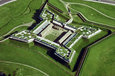
caption = Aerial view of Fort Stanwix
location = 112 E. Park St., Rome, NY
nearest_city =
area = 16 acres (6.4 ha)
established =August 21 ,1935
visitation_num = 84,933
visitation_year = 2002
governing_body =National Park Service Infobox_nrhp2 | name =Fort Stanwix
nhl=yes
nmon =yes
locmapin = New York
caption =
location=
lat_degrees = 43 | lat_minutes = 13 | lat_seconds = 7 | lat_direction = N
long_degrees = 75 | long_minutes = 27 | long_seconds = 32 | long_direction = W
area =
built =1758
designated_nhl =November 23 ,1962 cite web|url=http://tps.cr.nps.gov/nhl/detail.cfm?ResourceId=35&ResourceType=Building
title=Fort Stanwix|date=2007-09-13|work=National Historic Landmark summary listing|publisher=National Park Service]
added =October 15 ,1966 cite web|url=http://www.nr.nps.gov/|title=National Register Information System|date=2007-01-23|work=National Register of Historic Places|publisher=National Park Service]
refnum=66000057Fort Stanwix was a colonial fort whose construction was started on
August 26 1758 by British GeneralJohn Stanwix , at the location of present-dayRome, New York , but was not completed until about 1762. The fort guarded aportage known as the "Oneida Carrying Place" during theFrench and Indian War . A reconstructed fort has been built at the site by theNational Park Service , and the Fort Stanwix National Monument lies in the center of the modern city.Fort Stanwix was abandoned in 1768 and allowed to go to ruin.
In 1768, Fort Stanwix was the site of an important treaty conference between the British and the
Iroquois , arranged by William Johnson. By the time of this treaty the fort had become a dilapidated inactive fort. The purpose of the conference was to renegotiate the boundary line between Indian lands and white settlements set forth in theProclamation of 1763 . The British government hoped a new boundary line might bring an end to the rampant frontier violence, which had become costly and troublesome. Indians hoped a new, permanent line might hold back white colonial expansion.The final treaty was signed on November 5, and extended the earlier proclamation line much further west. The Iroquois had effectively ceded
Kentucky to the whites. However, the Indians who actually used the Kentucky lands, primarilyShawnee ,Delaware , andCherokee , had no role in the negotiations. Rather than secure peace, the Fort Stanwix treaty helped set the stage for the next round of hostilities.Fort Schuyler
The fort was reoccupied by Colonial troops under the command of Colonel
Elias Dayton in July 12, 1776. They began reconstruction of the fort and they renamed it Fort Schulyer, although many continued to call it Fort Stanwix. ColonelPeter Gansevoort took over command of the fort on May 3, 1776.On
August 3 , 1777 the fort was besieged by British forces under the command of Brigadier GeneralBarry St. Leger as part of a three-pronged attack (seeSaratoga Campaign ) to split American power in New York State. The fort commander, ColonelPeter Gansevoort , refused the terms of surrender offered by the British, and the siege commenced.On August 3, 1777 a flag was raised over the fort which some have claimed to have been the Stars and Stripes, but an analysis of the historical evidence has shown to have been the
Grand Union Flag [Fort Stanwix Construction and Military History] .The
Battle of Oriskany was fought when an American relief column, commanded by GeneralNicholas Herkimer , was ambushed byTories and their Indian allies. While many of the besiegers were attending to that battle, the defenders of the fort sallied forth and attacked the enemy camp, looting and destroying enemy stores. Demoralized and reduced in strength, the British withdrew when they heard reports of the approach of yet another relief column, led by GeneralBenedict Arnold . The British forces withdrew through Canada and joined Burgoyne's campaign atFort Ticonderoga .The British failure to capture the fort and proceed down the
Mohawk Valley was a severe setback and helped lead to the defeat of GeneralJohn Burgoyne at theBattle of Saratoga .The Fort burned to the ground on May 13, 1781 and was not rebuilt [Casemates and Cannonballs. Archaeological Investigations at Fort Stanwix ] . The fort was abandoned and the garrison was to take up quarters at
Fort Herkimer .The second Treaty of Fort Stanwix was conducted at the fort between the Americans and the Indians in 1784. During the
War of 1812 a blockhouse was built on the parade ground. Beginning in 1828 the fortifications were dismantled.The fort was designated a
National Historic Landmark , in 1962.cite web|url=http://tps.cr.nps.gov/nhl/detail.cfm?ResourceId=35&ResourceType=Building
title=Fort Stanwix|date=2007-09-13|work=National Historic Landmark summary listing|publisher=National Park Service] citation|title=PDFlink| [http://pdfhost.focus.nps.gov/docs/NHLS/Text/66000057.pdf National Register of Historic Places Inventory-Nomination: Fort Stanwix] |286 KB|author=Dwight T. Pitcaithley|date=August, 1981|publisher=National Park Service and PDFlink| [http://pdfhost.focus.nps.gov/docs/NHLS/Photos/66000057.pdf Accompanying 1 photo, aerial, from 1981.] |288 KB] The Park Service reconstructed the fort between 1974 and 1978.ee also
*
Oriskany Battlefield State Historic Site Notes
References
* "Casemates and Cannonballs. Archeological Investigations at Fort Stanwix, Rome, New York", by Lee Hanson, Dick Ping Hsu
* "Fort Stanwix Construction and Military History", by John F. Luzader, 2001, ISBN 1-888213-53-1External links
* [http://www.nps.gov/fost/index.htm Fort Stanwix National Monument]
* [http://www.nps.gov/history/NR/twhp/wwwlps/lessons/79oriskany/79oriskany.htm "The Battle of Oriskany: "Blood Shed a Stream Running Down"," a National Park Service Teaching with Historic Places (TwHP) lesson plan]
Wikimedia Foundation. 2010.