- Ochlockonee River
-
Ochlockonee River 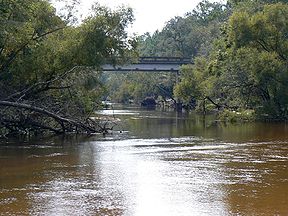 Ochlocknee River at the Old Bainbridge Road Bridge
Country United States States Georgia, Florida District NWFWMD Tributaries - right Little River, Telogia Creek, Crooked River Source - location Gordy, Georgia - coordinates 31°29′06″N 83°52′49″W / 31.485°N 83.88028°W Mouth Ochlockonee Bay - location Surf, Florida - coordinates 29°58′36″N 84°26′15″W / 29.97667°N 84.4375°W Length 206 mi (332 km) Basin 2,450 sq mi (6,345 km2) Discharge for Bloxham - average 1,796 cu ft/s (51 m3/s) 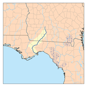 Ochlockonee River watershed
The Ochlockonee River is a fast running river originating in Georgia and flowing for 206 miles (332 km)[1] before terminating in Florida.
Contents
Background
The Ochlockonee originates south of the town of Sylvester in Worth County in southwest Georgia emptying into Ochlockonee Bay, then into Apalachee Bay, in Florida. In Florida, the river forms the western boundaries of Leon County and Wakulla County and eastern boundaries of Gadsden County, Liberty County, and Franklin County.
The Ochlockonee flows through the Red Hills, Talquin State Forest, Lake Talquin State Park and the Apalachicola National Forest, and past Ochlockonee River State Park, where it is tidally influenced and a mixture of fresh, brackish, and salt water,[2] on the way to its terminus in Ochlockonee Bay, which then empties into Apalachee Bay, with tidal influences extending upstream over 15 miles (24 km) from the river's mouth.[3]
History
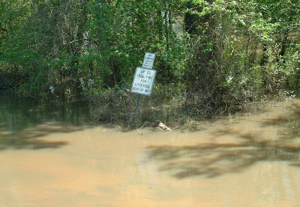
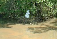 Ochlockonee flooding in Gadsden Co., Florida, near Fairbanks Ferry Road Bridge.
Old Spanish documents sometimes refer to the Ochlockonee River as the Rio Agna and in other instances as the Rio de Lagna, while a map from 1683 shows it as the Rio Lana. The names Lagna and Lana may be Spanish renditions of the Muskogean word LAH'nee, which translates as "yellow". The rich yellows and reds of Red Hills clay give the river a yellowish color. Eighteenth century English maps give the name as Ogeelaganu or Ochloconee, which probably retains at least the flavor of its Hitchiti name. Variations of these continued into century with O-clock-ney being used in 1822 and Ockatockany in 1855.[4]
About 1840, Fort Stansbury was established on the river by placing a two story home that had been abandoned by its owner due to Seminole raids during the Second Seminole War. This fort was important in the forced removal of Indians from the area. Boats traveled upriver to collect and move Native Americans down to Gulf of Mexico ports for removal to "Indian Territories." By 1844, Fort Stansbury had been abandoned.[4]
From 1839 to 1842, Fort Virginia Braden was established on the river located at Fort Braden in Florida. The fort was named after the commander's wife who died of yellow fever.
The Civil War
The Ochlockonee River saw action during the Civil War. On 15 July 1863 the screw steamer gunboat USS Stars and Stripes and wooden side-wheel steam ferryboat USS Somerset attacked the salt works at Mashes Sands. On 29 December 1863 Stars and Stripes sank the blockade-running schooner Caroline Gertrude, aground on the sandbar at the mouth of the Ochlockonee. Stars and Stripes also captured the blockade-running steamer Laura off the Ochlockonee on 18 January 1864. On 19 and 20 October 1864 Stars and Stripes destroyed an extensive Confederate fishery at Mashes Island and captured the troops stationed there as guards.[4]
Importance
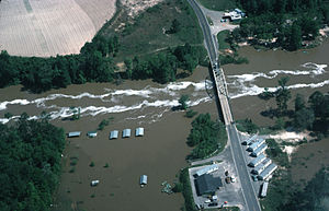 Aerial view of the Ochlockonee River in flood on April 16, 1975 near Bloxham, just southwest of the modern State Highway 20 bridge crossing and the Talquin Dam.
The Ochlockonee River corridor is home to many threatened fish, wildlife and plant species. It is a State of Florida designated Outstanding Florida Water and has been identified by the Florida Fish and Wildlife Conservation Commission as a Strategic Habitat Conservation Area.[5]
Rare animals that can be found along the Ochlockonee include Red-cockaded Woodpecker, Least Tern, and the Apalachicola Dusky Salamander.[5] The river is especially rich in rare freshwater mussels (Unionidae), including three federally listed endangered species: the Ochlockonee moccasinshell, the Shinyrayed pocketbook, and the Oval pigtoe.[6] "The Florida maybell tree can be found only along the Ochlockonee and Chipola Rivers.[5]
The Ochlockonee is connected to and a source of water for Lake Iamonia especially during flooding.
Recreation
Fishing for bass, perch, bream and catfish can be excellent on the Ochlockonee River, and a state-designated canoe trail can be found both upstream and downstream of Lake Talquin. Telogia Creek and the Little River near State Road 12 are also popular for canoeing.[5] The Florida National Scenic Trail follows the river for two miles.[5]
The Ochlockonee is a vital link in the production of seafood to the southwest in Apalachicola Bay. During floods, the river transports organic matter downstream into the estuary of Ochlockonee Bay where the shallows of the bay were created by the great volume of sand and clay brought down by the river. This estuary serves as a nursery for numerous species of fish and shellfish which are the basis for recreational and commercial fishing as well as the Apalachicola seafood that this area is known for.
Crossings
A number of major highways cross the Ochlockonee River along its course, including Interstate 10 and U.S. highways 19, 27 and 98.
References
- ^ Fernald, Edward A.; Patton, Donald J., eds (1984). Water Resources Atlas of Florida. Florida State University Institute of Science and Public Affairs. ISBN 0-9606708-1-5.
- ^ "Ochlockonee River State Park". http://www.floridastateparks.org/ochlockoneeriver/. Retrieved 2007-01-11.
- ^ Boning, Charles R. 2007. Florida's Rivers. Sarasota, Florida: Pineapple Press, Inc. ISBN 978-1-56164-400-1
- ^ a b c "Frank Howard". The Ochlockonee River. http://www.littletownmart.com/fdh/ochlockonee.htm. Retrieved 2007-01-11.
- ^ a b c d e "1000 Friends of Florida". The Ochlockonee River. http://www.1000friendsofflorida.org/PUBS/Apalachee/ochlockonee.asp. Retrieved 2007-01-11.
- ^ Hemming, Jon M. et al., 2006, Water and sediment quality at mussel (Unionidae) habitats in the Ochlockonee River of Florida and Georgia. Endangered Species Research 2: 37-49.
External links
- Ochlockonee River Soil and Water Conservation District
- Ochlockonee River Watershed - Florida DEP
- U.S. Geological Survey Geographic Names Information System: Ochlockonee River
Coordinates: 29°58′36″N 84°26′15″W / 29.97667°N 84.4375°W
Categories:- American Heritage Rivers
- Rivers of Florida
- Rivers of Georgia (U.S. state)
- Landforms of Franklin County, Florida
- Geography of Leon County, Florida
- Geography of Wakulla County, Florida
- Geography of Gadsden County, Florida
- Geography of Liberty County, Florida


Wikimedia Foundation. 2010.