- Nimruz Province
-
Nimruz (نیمروز) Province Country Afghanistan Capital Zaranj - coordinates 31°00′N 62°30′E / 31.0°N 62.5°E Area 41,005 km2 (15,832 sq mi) Population 149,000 (2002) [1] Density 3.634 / km2 (9 / sq mi) Governor Ghulam Dastagir Azad Timezone UTC+4:30 Main languages Balochi
Pashto
Persian Map of Afghanistan with Nimruz highlighted
Nimruz (Balochi/Pashto/Persian: نیمروز ) is one of the thirty-four provinces of Afghanistan, in the south-west of the country on the borders of Iran and Pakistan. The name Nimruz means "mid-day" or "half-day" in Persian. Nimruz covers 41,000 km² and has a population of 149,000 (2002 estimate). It is the most sparsely populated province in the country, located in the Sistan Basin. A substantial part of the province is the desert area of Dashti Margo.
Contents
History
Further information: History of AfghanistanThe area now composing Nimruz Province of Afghanistan was once part of the historical region of Sistan, which over the centuries was held by powers ranging from the Medean Empire to Alexander the Great, to the Kushan Empire before being conquered and converted to Islam by the Arab Rashidun Caliphate in the 7th century. The area came under the Saffarid dynasty in 860 CE with its capital being the city of Zaranj in Nimruz, which was one of the first local dynasties of the Islamic era. Its founder Yaqub Saffari was born and raised in this region. The territory became part of the Ghaznavids followed by the Ghurids, Timurids, and Safavids.
In the early 18th century, the region fell to the Afghan Hotaki dynasty until they were removed from power in 1738 by Nader Shah of Khorasan. By 1747, Ahmad Shah Durrani made it part of Afghanistan after he conquered the territory from northeastern Iran to the Indian subcontinent. Under the modern Afghan governments, the province was known as Chakhansur Province until 1968, when it became Nimruz Province.[1] The city of Zaranj became the capital of Nimroz province.
As the Taliban came to power in the area in 1995, they seized the road-controlling town of Delaram (then in southwestern Farah Province), and came to an agreement with the Mujahideen forces holding Nimroz that the fate of the province would not be decided until a clear victor emerged in the capture of Kabul. However, the Taliban advanced on Nimruz only days later, and the Mujahideen under command of Abdul Karim Brahui (later governor of Nimruz) withdrew to Iran. The Mujahideen briefly recaptured Zaranj later in 1995, but the city was retaken by the Taliban, and the capital later moved from Zaranj to the more Pashtun-populated town of Ghurghuri. The Taliban fled, losing control of the province, following U.S. airstrikes in November 2001.[2] The 215th Corps in Lashkar Gah is in charge of the military while the Afghan National Police are in charge of the law inforcement and the Afghan Border Police are securing the nation's border with Iran and Pakistan. The area is known for major drugs and weapons smuggling between Afghanistan, Iran and Pakistan. Many foreign militants also use the area to go back and forth between the 3 nations.
Demography
Further information: Demography of AfghanistanAccording to a 2006 provincial assessment provided by the United Nations Assistance Mission in Afghanistan (UNAMA).
Around four fifths (85%) of the population of Nimroz lives in rural districts while 15% lives in urban areas. Around 51% of the population is male and 49% is female. The major ethnic groups living in Nimroz province are Baluchi and Pashtoons, followed by Tajiks and Uzbeks. Baluchi is spoken by 61% of the population and 83% of the villages. The second most frequent language is Pashtu, spoken by the majorities in 39 villages representing 27% of the population, followed by Dari and Uzbeki each spoken by 10% of the population.[3]Districts
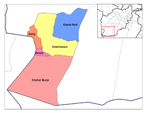 Districts of Nimruz
Districts of Nimruz Province District Capital Population Area[4] Chahar Burjak 8,080 Chakhansur 11,165 Kang 13,514 Khash Rod 35,381 Zaranj Zaranj (capital city) 49,851 Politics
Governors
Further information: List of governors of NimrozThe current governor is Abdul Karim Barahawi.
 Chakhansur, Nimruz
Towns and villages
Amenities
An airport was built on three kilometres of land in 1969 that had a small runway and was located near residential houses in the provincial capital Zaranj, however big airplanes could not land and take off there. In 2011 the construction work on a new airport took place that was funded by the Ministry of Transport and Civil Aviation, the new airfield costing $1,250,000 would be constructed in a year on 6.75km2 of land. The new airport would be built in a desert, 22km of Zaranj. The facility would pave the ground for big planes to operate, there were incidents in 1995 and 2008 where two N-32 planes had skidded off the airstrip and hit nearby houses.[5]
Airlines serving the province
References
- ^ Frank Clements. Conflict in Afghanistan: a historical encyclopedia. ABC-CLIO, 2003. ISBN 1851094024, 9781851094028. Pg 181
- ^ Robert D. Crews, Amin Tarzi. The Taliban and the crisis of Afghanistan. Harvard University Press, 2008. ISBN 067402690X, 9780674026902. Pg 185-187
- ^ "B. Demography and Population". United Nations Assistance Mission in Afghanistan and Afghanistan Statistical Yearbook 2006, Central Statistics Office. Afghanistan's Ministry of Rural Rehabilitation and Development. http://www.mrrd-nabdp.org/Provincial%20Profiles/Nimroz%20PDP%20Provincial%20profile.pdf. Retrieved 2011-01-12.
- ^ Afghanistan Geographic & Thematic Layers
- ^ http://www.pajhwok.com/en/2011/11/03

Farah Province 
Helmand Province  Nimruz Province

Sistan and Baluchistan Province,  Iran
IranBalochistan,  Pakistan
Provinces of Afghanistan Badakhshan · Badghis · Baghlan · Balkh · Bamyan · Daykundi · Farah · Faryab · Ghazni · Ghor · Helmand · Herat · Jowzjan · Kabul · Kandahar · Kapisa · Khost · Kunar · Kunduz · Laghman · Logar · Nangarhar · Nimruz · Nuristan · Oruzgan · Paktia · Paktika · Panjshir · Parwan · Samangan · Sar-e Pol · Takhar · Wardak · Zabul

 Baloch nationalism
Regions Balochistan • Balochistan, Pakistan • Sistan and Baluchestan Province (Iran) • Balochistan, AfghanistanParties and
student groupsBalochistan National Party • Jamhoori Wattan Party • National Party • Baloch National Movement • Baloch Republican Party • Baloch National Front • Baloch Students Organization • Baloch Students Organization – Awami • Balochistan People's Party • Kalat State National PartyMilitant groups Balochistan Liberation Army • Baloch Liberation Front • Baluch People's Liberation Front • Popular Front for Armed Resistance • Baluchi Liberation Front • Baluchi Autonomist Movement • Partisans of National Liberation of Afghanistan • Baloch Republican Army • Balochistan Liberation United Front • Parrari • JundallahKey figures Gul Khan Nasir • Abdul Hai Baloch • Habib Jalib Baloch • Hameed Baloch • Ghulam Mohammed Baloch • Mir Nooruddin Mengal • Allah Nazar Baloch • Ghaus Bakhsh Bizenjo • Hasil Bizenjo • Akbar Bugti • Brahamdagh Khan Bugti • Prince Karim Khan • Mir Lawang Khan • Nawab Nowroz Khan • Abdul Aziz Kurd • Yousaf Aziz Magsi • Balach Marri • Khair Bakhsh Marri • Jumma Khan Marri • Sher Mohammad Marri • Akhtar Mengal • Ataullah Mengal • Abdolmalek Rigi • Dad ShahHistory Kalat (princely state) • Balochistan conflict • 1970s Operation • Iraqi support • Arms discovery in Iraqi Embassy • Turbat killings • Missing personsNational
myths/epicsCategories:- Provinces of Afghanistan
- Nimruz Province
- Afghanistan geography stubs


Wikimedia Foundation. 2010.