- Japanese addressing system
-
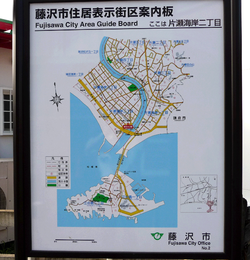 The Area Guide Board at Katase-Kaigan 2-chōme area, Fujisawa, Kanagawa. Block (banchi) is indicated with circled number and building number (gō) is not displayed.
The Japanese addressing system is used to identify a specific location in Japan. In Japanese, addresses are written using the opposite convention from Western addresses, starting with the biggest geographical entities down to the more specific ones.
Contents
Address parts
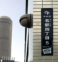 A town block indicator plate (街区表示板 gaiku-hyōjiban) displaying the address Nakamura-ku, Meieki 4-chōme, 5-banchi (in Nagoya).
Japanese addresses begin with the largest division of the country, the prefecture. These are generally called ken (県), but there are also three other special prefecture types: to (都) for Tokyo, dō (道) for Hokkaidō and fu (府) for the two urban prefectures of Osaka and Kyoto.
Following the prefecture is the municipality. For a large municipality this is the city (shi, 市). Tokyo has both ordinary cities and special wards (ku, 区), each of which has the status of a city. For smaller municipalities, the address includes the district (gun, 郡) followed by the town (chō or machi, 町) or village (mura or son, 村).
The next element of the address is the location within the municipality. Many cities have wards (ku, 区), which in turn may be divided into machi or chō (町). Towns may have smaller parts with names like chō, ōaza (大字), or aza (字), or even smaller koaza (小字).
The final three elements of the address in Jukyo hyōji style are the city district (chōme 丁目), the city block (ban 番) and finally the house number (gō 号). Chōme and ban numbers are usually assigned by order of proximity to the center of the municipality. Gō numbers are usually assigned by clockwise order around the ban city block. The final three elements of the address in Chiban style are the city district (chōme 丁目), the land number (banchi 番地) and finally the land number extension. The land number and land number extension designate a piece of land registered in the land registry. A land number extension is assigned when a piece of land is divided into two or more pieces in the registry. As these are all numbers, they are usually simply written as a string, 1-2-3, starting with the chōme and ending in the gō. In urban apartment buildings it is not unusual to add the apartment number as a fourth element. This three-element system is relatively new introduction, and is not completed in some areas such as older area of the cities or sparsely populated rural areas, where only the banchi is written after machi or aza.
 A sign displaying the town address Kamimeguro 2 chōme; block (banchi) 21, building (gō) 9 identifies the residential address. The upper plaque is the chōme-name plate (町名板) and the lower, the residential number plate (住居番号板).
Street names are seldom used in postal addresses (except in Kyoto and some Hokkaidō cities such as Sapporo), and most Japanese streets do not have names. Banchi blocks often have an irregular shape, as banchi numbers were assigned by order of registration in the older system, meaning that especially in older areas of the city they will not run in a linear order. It is for this reason that when giving directions to a location, most people will offer cross streets, visual landmarks and subway stations such as "at Chūō-dori and Matsuya-dori across the street from Matsuya and Ginza station", for a store in Tokyo. In fact, many businesses have maps on their literature and business cards. In addition, signs attached to utility poles often specify the city district name and block number, and detailed block maps of the immediate area are sometimes posted near bus stops and train station exits.
In addition to the address itself, all locations in Japan have a postal code. After the reform of 1998, this begins with a three-digit number, a hyphen, and a four-digit number, for example 123-4567. A postal mark, 〒, may precede the code to indicate that the number following is a postal code.
Address order
In Japanese, the address is written in order from largest unit to smallest, with the addressee's name last of all. For example, the address of the Tokyo Central Post Office is
- 〒100-8994
東京都中央区八重洲一丁目5番3号
東京中央郵便局
- 〒100-8994
Tōkyō-to Chūō-ku Yaesu 1-Chōme 5-ban 3-gō
Tōkyō Chūō Yūbin-kyoku'
or
- 〒100-8994
東京都中央区八重洲1-5-3
東京中央郵便局
- 〒100-8994
Tōkyō-to Chūō-ku Yaesu 1-5-3
Tōkyō Chūō Yūbin-kyoku
The order is reversed when writing in roman letters, to better suit Western conventions. The format recommended by Japan Post is:
- Tokyo Central Post Office
5-3, Yaesu 1-Chome
Chuo-ku, Tokyo 100-8994
In this address, Tokyo is the prefecture; Chuo-ku is one of the special wards; Yaesu 1-Chome is the name of the city district; and 5-3 is the city block and building number. In practice it is common for the chōme to be prefixed, as in Japanese, resulting in the somewhat shorter
- Tokyo Central Post Office
1-5-3 Yaesu, Chuo-ku
Tokyo 100-8994.
Special cases
As mentioned above, there are certain areas of Japan that use somewhat unique address systems. Sometimes the differing system has been incorporated into the official system, as in Sapporo, while in Kyoto the system is completely different from, but used alongside the official system. Kyoto and Sapporo have addresses based on their streets being laid out in a grid plan, unlike most Japanese cities.
Kyoto
 Kyoto was laid out on a grid in 794 (Heian-kyō), and grid-based addresses are used.
Although the official national addressing system is in use in Kyoto – in Chiban style, with ward (区 ku), district (丁目 chōme), and land number (番地 banchi), the chō divisions are very small, numerous, and there is often more than one chō with the same name within a single ward, making the system extremely confusing. As a result, most residents of Kyoto use an unofficial system based instead on street names, a form of vernacular geography. This system is, however, recognized by the post office and by government agencies.
For added precision, the street-based address can be given, followed by the chō and land number. Sometimes multiple houses share a given land number, in which case the name (either just family name, or full name of resident) must also be specified; this name is generally displayed in front of the house on a hyōsatsu (表札, name plate), often decoratively presented, as house numbers are in other countries.
The system works by naming the intersection of two streets and then indicating if the address is north (上ル agaru, "above"), south (下ル sagaru, "below"), east (東入ル higashi-iru, "enter east"), or west (西入ル nishi-iru, "enter west") of the intersection. More precisely, the two streets of the intersection are not treated symmetrically: one names the street that the address is on, then gives a nearby cross street, and then specifies the address relative to the cross street. What this means is that a building can have more than one address depending on which cross street intersection is chosen.
The official address to Kyoto Tower is:[1]
- 〒600-8216
- 京都府京都市下京区東塩小路721-1
- Higashi-Shiokōji 721-1, Shimogyō-ku, Kyōto-shi, Kyōto-fu 600-8216
However, the informal address to Kyoto Tower,[2] is:
- 〒600-8216
- 京都府京都市下京区烏丸七条下ル
- Karasuma-Shichijō-sagaru, Shimogyō-ku, Kyōto-shi, Kyōto-fu
This address means "south of the intersection of Karasuma and Shichijō streets" – more precisely, "on Karasuma, below (south of) Shichijō" (Karasuma runs north-south, while Shichijō is an east-west cross street). The street address may alternatively be given as 烏丸通七条下ル (with street (通 dōri) inserted), indicating clearly that the address is on Karasuma street.
However, the system is flexible and allows for various alternatives, such as:
- 京都府京都市下京区烏丸塩小路上ル
- Karasuma-Shiokōji-agaru, Shimogyō-ku, Kyōto-shi, Kyōto-fu
- "(On) Karasuma (street), above (north of) Shiokōji (street)"
For less well known buildings, the official address is often given after the informal one, as in the address for the Shinatora Ramen restaurant:
- 京都府京都市下京区烏丸通五条下ル大坂町384
- Ōsakachō 384, Karasuma-dōri-Gojō-sagaru, Shimogyō-ku, Kyōto-shi, Kyōto-fu
- "Ōsakachō 384, (on) Karasuma street, below (south of) Gojō"
Sapporo
Sapporo’s system, though official, differs in structure from regular Japanese addresses. The city is divided into quadrants at its centre by two intersecting roads. Blocks are then named based on their distance from this point. The east-west distance is indicated by chōme (which is a slightly different usage of chōme when compared to other cities), while the north-south distance is indicated by jō, which has been incorporated into the chō name.
The address to Sapporo JR Tower [2] is:
札幌市中央区北5条西2丁目5番地
Kita-5-jō Nishi-2-chōme 5-banchi, Chūō-ku, Sapporo-shi
This address indicates that it is the fifth building on a block located 5 blocks north (kita) and 2 blocks west (nishi) of the centre.
Although the streets of Sapporo form a fairly clean grid, outside of the city centre it gets less and less practical to use the original grid starting point. In these cases an arbitrary dividing starting point is chosen from which to measure the counting of chōme and jō.
Ishikawa Prefecture
Some cities in Ishikawa Prefecture, including Kanazawa and Nanao, sometimes use Katakana with ordering of Iroha instead of numbers for blocks. These katakana are called bu (部).
For example, the address of the Kagaya Hotel [3] in Nanao is:
〒926-0192
石川県七尾市和倉町ヨ80
Wakuramachi yo 80, Nanao-shi, Ishikawa-ken 926-0192
History
The current addressing system was established after World War II as a slight modification of the scheme used since the Meiji era.
For historical reasons, names quite frequently conflict. In Hokkaidō many place names are identical to names found in the rest of Japan; this is largely the result of past immigration into Hokkaidō of people from mainland Japan. Historians note that there is also a significant similarity between place names in Kansai region and those in northern Kyūshū. See Japanese place names for more.
Gallery
-

Two "chōme-name plates(町名板)" are with Romaji for people unable to read the Japanese. Left plate is Ginza 4 chōme road cross at 5 chōme 7-2, next to "Ginza 4 chōme koban", where the opposite side of main street from Wakō. Right plate is Shimbashi 2 chōme, block name is "underground city of (Shimbashi station) east exit (東口地下街)" without banchi number.
-

An older chōme address name plate in Kuwabara, a residential section of Matsuyama, Ehime. The address of this block in Japanese is 愛媛県松山市桑原4丁目3.
See also
References
External links
- Japanese telephone directory (no longer available)
- Lookup Japanese addresses in English
Categories:- Communications in Japan
- Postal system of Japan
- Government of Japan
- 〒100-8994


Wikimedia Foundation. 2010.