Besthmen — 52°30′10″N 6°25′50″E / 52.50278, 6.43056 … Wikipédia en Français
Ommen — Héraldique … Wikipédia en Français
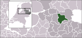
Ommen — Municipality The Sahara near Ommen … Wikipedia
List of places in the Netherlands — This is an alphabetical list of places (cities, towns, villages) in the Netherlands. Lists per province can be found at:* List of towns in Groningen * List of towns in Friesland * List of towns in Drente * List of towns in Overijssel * List of… … Wikipedia
Arriën — 52°31′37″N 6°26′59″E / 52.52694, 6.44972 … Wikipédia en Français
Beerze (Overijssel) — 52°30′49″N 6°31′43″E / 52.51361, 6.52861 … Wikipédia en Français
Beerzerveld — 52°29′38″N 6°34′36″E / 52.49389, 6.57667 … Wikipédia en Français
Dalmsholte — 52°28′32″N 6°21′54″E / 52.47556, 6.365 … Wikipédia en Français
Giethmen — 52°29′30″N 6°24′20″E / 52.49167, 6.40556 … Wikipédia en Français
Lemele — 52°27′8″N 6°24′53″E / 52.45222, 6.41472 … Wikipédia en Français