- Mopani District Municipality
-
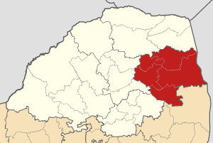 A map of Limpopo showing Mopani District
Mopani is one of the 6 districts of Limpopo province of South Africa. The seat of Mopani is Giyani. The majority of its 964 195 people speak Tsonga or Northern Sotho (2001 Census). The district code is DC33. After the 12th amendment of the Constitution of South Africa part of the area of the Bohlabela district was incorporated into Mopani.
Contents
Geography
Neighbours
Mopani is surrounded by:
- the republic of Zimbabwe to the north
- the republic of Mozambique to the east
- Ehlanzeni (DC32) to the south
- Sekhukhune (DC35) to the south-west
- Capricorn (DC35) to the west
- Vhembe (DC34) to the north-west
Local municipalities
The district contains the following local municipalities:
Local municipality Population % Maruleng 98 550 ?% Greater Tzaneen 375 588 38.95% Greater Giyani 237 436 24.63% Greater Letaba 220 126 22.83% Ba-Phalaborwa 131 081 13.59% Demographics
The following statistics are from the 2001 census.
Language Population % Tsonga 468 120 48.55% Northern Sotho 446 993 46.36% Afrikaans 18 131 1.88% Sotho 13 145 1.36% English 6 028 0.63% Venda 4 518 0.47% Zulu 2 149 0.22% Swati 2 014 0.21% Tswana 1 042 0.11% Other 923 0.10% Xhosa 833 0.09% Ndebele 335 0.03% Gender
Gender Population % Female 525 744 54.53% Male 438 451 45.47% Ethnic group
Ethnic group Population % Black African 940 970 97.59% White 21 457 2.23% Coloured 1 191 0.12% Indian/Asian 577 0.06% Age
Age Population % 000 - 004 104 678 10.86% 005 - 009 127 340 13.21% 010 - 014 137 175 14.23% 015 - 019 125 872 13.05% 020 - 024 90 804 9.42% 025 - 029 72 105 7.48% 030 - 034 58 523 6.07% 035 - 039 53 565 5.56% 040 - 044 44 346 4.60% 045 - 049 37 952 3.94% 050 - 054 27 961 2.90% 055 - 059 19 667 2.04% 060 - 064 19 862 2.06% 065 - 069 14 470 1.50% 070 - 074 13 493 1.40% 075 - 079 6 466 0.67% 080 - 084 6 243 0.65% 085 - 089 2 011 0.21% 090 - 094 1 145 0.12% 095 - 099 368 0.04% 100 plus 149 0.02% Politics
Election results
Election results for Mopani in the South African general election, 2004.
- Population 18 and over: 515 110 [53.42% of total population]
- Total votes: 304 747 [31.61% of total population]
- Voting % estimate: 59.16% votes as a % of population 18 and over
Party Votes % African National Congress 275 058 90.26% Democratic Alliance 11 012 3.61% African Christian Democratic Party 5 800 1.90% United Democratic Movement 4 444 1.46% Pan African Congress 1 986 0.65% New National Party 1 119 0.37% Azanian People's Organisation 998 0.33% Freedom Front Plus 904 0.30% Inkhata Freedom Party 696 0.23% Independent Democrats 533 0.17% United Christian Democratic Party 425 0.14% NA 326 0.11% SOPA 248 0.08% PJC 234 0.08% EMSA 208 0.07% CDP 202 0.07% UF 170 0.06% TOP 141 0.05% Minority Front 84 0.03% KISS 83 0.03% NLP 76 0.02% Total 304 747 100.00% See also
References
External links
- Mopani DM Official website
- Stats SA Census 2001 page
- Independent Electoral Commission 2004 election results
Province of Limpopo, South Africa Provincial Capital: Polokwane District
and Local
MunicipalitiesMopaniGreater Giyani · Greater Letaba · Greater Tzaneen · Ba-Phalaborwa · MarulengBlouberg · Aganang · Molemole · Polokwane · Lepelle-NkumpiEphraim Mogale · Elias Motsoaledi · Makhuduthamaga · Fetakgomo · Greater TubatseCategories:- Limpopo geography stubs
- District municipalities of Limpopo

Wikimedia Foundation. 2010.