- Clères
-
Clères

 ClèresLocation within Upper Normandy region
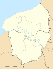 Clères
Administration Country France Region Upper Normandy Department Seine-Maritime Arrondissement Rouen Canton Clères (chef-lieu) Intercommunality Portes Nord-Ouest de Rouen Mayor Nathalie Thierry
(2001–2008)Statistics Elevation 63–181 m (207–594 ft)
(avg. 113 m/371 ft)Land area1 11.36 km2 (4.39 sq mi) Population2 1,324 (2006) - Density 117 /km2 (300 /sq mi) INSEE/Postal code 76179/ 76690 1 French Land Register data, which excludes lakes, ponds, glaciers > 1 km² (0.386 sq mi or 247 acres) and river estuaries. 2 Population without double counting: residents of multiple communes (e.g., students and military personnel) only counted once. Coordinates: 49°36′01″N 1°06′40″E / 49.6002777778°N 1.11111111111°E
Clères is a commune in the Seine-Maritime department in the Haute-Normandie region in northern France.
Contents
Geography
A large farming and forestry village situated by the banks of the Clérette river, in the Pays de Caux, some 17 miles (27 km) northeast of Rouen, at the junction of the D2, D6, D53 and the D100 roads. SNCF has a TER railway station in the town.
Heraldry
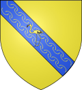
The arms of Clères are blazoned :
Argent, a bend azure diapered Or, charged with a flamingo Or.Population
Historical population of Clères 1962 1968 1975 1982 1990 1999 2006 1006 1055 1091 1302 1254 1266 1324 From the year 1962 on: population without double counting—residents of multiple communes (e.g. students and military personnel) are counted only once. Places of interest
- The church of Sts. Waast-&-Nicolas, dating from the sixteenth century.
- The church of St. Sauveur at Cordelleville, dating from the twelfth century.
- The church of Notre-Dame at the hamlet of Tot, dating from the twelfth century.
- A chateau and its park, home of the zoo.
- A seventeenth century sandstone cross.
- Ruins of a medieval castle.
- Several ancient wood-framed houses.
- The eighteenth century market hall ‘Les Halles’.
People with links to the commune
- Jean Delacour, ornithologist, lived here.
Twin towns
 Goldenstedt, Germany, since 1989
- Leverkusen, Germany, since 2000
See also
References
Bibliography
- Hippolyte Lemarchand, Histoire du canton de Clères, 1891 ; Le Pucheux, Fontaine-le-Bourg, 2002 ISBN|2-9517552-2-8
External links
- Clare, Clere, and Clères A paper on the origin of the town's name.
- Tourist Office website (French)
- Clères on the Quid website (French)
- Site Perso sur CLERES (French)
Categories:- Communes of Seine-Maritime
- Rouen geography stubs


Wikimedia Foundation. 2010.