- New York State Route 19
-
"NY 19" redirects here. NY 19 may also refer to New York's 19th congressional district.This article is about the current alignment of NY 19. For the former alignment of NY 19 in Ulster and Delaware Counties, see New York State Route 19 (1924–1930).
NYS Route 19

Map of New York with NY 19 highlighted in redRoute information Maintained by NYSDOT Length: 108.62 mi[2] (174.81 km) Existed: 1930[1] – present Major junctions South end:  PA 449 at Willing
 I-86 / NY 17 near Belmont
 NY 39 in Pike
 US 20A in Warsaw
 US 20 in Pavilion


 I-490 to I-90 / Thruway near Bergen village
 NY 31 near Brockport
North end:  Lake Ontario Parkway in Hamlin
Location Counties: Allegany, Wyoming, Genesee, Monroe Highway system Numbered highways in New York
Interstate • U.S. • N.Y. (former) • Reference • County←  NY 18F
NY 19A  →
→New York State Route 19 (NY 19) is a north–south state highway in Western New York in the United States. It is the longest state highway in that region, and the only other one besides NY 14 to completely transect the state from the Pennsylvania state line to the shore of Lake Ontario. It continues south into Pennsylvania as Pennsylvania Route 449 (PA 449) and ends at an intersection with the Lake Ontario State Parkway just south of the lakeshore in Hamlin. NY 19 does not serve any major cities or metropolitan areas and remains a two-lane rural road for almost its entire length. However, it follows the Genesee River for much of its lower length, and offers easy access to the gorges of Letchworth State Park midway along its route.
Most of modern NY 19 between Wellsville and Le Roy was originally designated as part of a legislative route in 1908. Much of this stretch was included in Route 16, an unsigned highway that initially extended from Cuba to Le Roy via Belfast. In 1921, Route 16 was altered to follow the path of what is now NY 19A instead. The first set of posted routes in New York were assigned in 1924, at which time the Wellsville–Belvidere segment of modern NY 19 was designated as part of NY 17 and a small portion of NY 19 in Brockport became part of NY 3. Within two years, the pre-1921 routing of legislative Route 16 from Belfast to Pavilion was designated as part of New York State Route 62, a new route that began at Belvidere and passed through Pavilion before following modern NY 63 northwest to the Lake Ontario shoreline north of Lyndonville.
In the 1930 renumbering of state highways in New York, NY 17 was altered to follow a more southerly routing between Olean and Wellsville while NY 62 became the basis for NY 19, which continued south of Belvidere to the Pennsylvania state line. The portion of what is now NY 19 north of Pavilion was initially part of NY 63; the alignments of NY 19 and NY 63 were flipped north of Pavilion ca. 1939. Only minor realignments and maintenance transfers have occurred since.
Contents
Route description
Allegany County accounts for about a third of NY 19's total length, with the other three counties splitting the rest about equally.[2]
Allegany County
PA 449 becomes NY 19 just north of Genesee, Pennsylvania, as it runs along the Genesee River through a narrow valley. Just south of the first New York community it encounters, the hamlet of Shongo in the Town of Willing, it crosses the river. Running a little further from the waterway, NY 19 reaches another hamlet, Stannards, several miles further north, along with its first state highway junction, NY 248, which leaves to the east.[3]
 NY 19 southbound at NY 248 in Stannards
After Stannards, NY 19 crosses Chenunda Creek as the Genesee Valley widens somewhat, and continues north to the village of Wellsville, the largest community in Allegany County. It merges with NY 417, the east–west former route of NY 17 through the village, following a four-lane arterial along the Genesee River, which here runs through a concrete-lined flood control channel. North of Wellsville, the NY 19 corridor remains fairly well-developed as the highway makes its way to the smaller village of Belmont, the county seat. Here NY 19 crosses the Genesee River for the last time, and NY 244 leaves for Alfred to the east at the village center.[3]
A mile past Belmont, NY 19 has its only direct freeway interchange, with the Southern Tier Expressway (NY 17 and Interstate 86 or I-86). Beyond it, it follows the river closely through the hamlet of Belfast, where NY 305 terminates. The next junction with another state highway, NY 243, comes at Caneadea, the next hamlet. It continues northward, passing through Houghton, home to Houghton College. NY 19A splits off in Fillmore to continue the riverside course and provide access to Letchworth State Park, while NY 19 climbs out of the valley and out of Allegany County.[3]
Wyoming County
 NY 19 north and NY 39 east in Pike
After the short bend where it crosses the Wyoming County line, NY 19 bends slightly to the west as it comes into the hamlet of Pike a mile to the north. The hamlet itself does not present any major intersections; however, NY 19 meets NY 39, the main east–west road across southern Wyoming County, northeast of the hamlet. The two routes overlap for just over 0.5 miles (0.8 km) before NY 19 turns back to the north and heads across mostly open fields to the next village, Gainesville, a few miles further on. Again the intersecting state highway is displaced to the north of the village, where NY 78 heads off to the east despite being signed as a north–south route.[3]
The route heads northeast from Gainesville to the hamlet of Rock Glen outside of Silver Springs, where NY 19A returns to its parent route and NY 19 passes under the Norfolk Southern Railway-owned Southern Tier Line. A few miles further on, NY 19 reaches another county seat, Warsaw. The highway, along with the intersecting U.S. Route 20A (US 20A), serves as one of the village's two commercial axes. Upon leaving Warsaw to the north, NY 19, having trended slightly to the west since the state line, reaches its apex and begins to go slightly to the northeast for the remainder of the route. It begins this new course while running through the Wyoming Valley, formed by Oatka Creek, a tributary of the Genesee River. At the Middlebury–Covington town line, NY 19 takes a sudden right turn from its route to follow Schwytzer – East Bethany Road for three miles (5 km) to Silver Springs Road, where it once again assumes a due north heading as it begins to parallel the Rochester and Southern Railroad and enters Genesee County.[3]
Genesee and Monroe Counties
Almost immediately after the county line NY 19 intersects NY 63 at a traffic light in the hamlet of Pavilion. The similarly named but smaller Pavilion Center 2 miles (3.2 km) to the north marks the junction—a pseudo-parclo interchange—with US 20. NY 19 follows the Rochester and Southern Railroad into the village of Le Roy, where NY 19 intersects the state's other major east–west route, NY 5, and crosses the railroad as it turns eastward to access Caledonia. Outside of Le Roy, the route begins to leave Oatka Creek behind as the river and the route both descend the Onondaga Escarpment. Shortly afterwards, it crosses the I-90 segment of the New York State Thruway just west of where I-490 leaves the Thruway. While NY 19 is signed for this exit along the Thruway, access to it comes via the first exit on I-490, which is accessed via connector roads as the two highways do not directly intersect.[3]
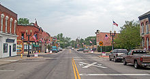 Downtown Bergen
North of the Thruway, NY 19 enters the village of Bergen, intersecting NY 33 south of the village and NY 262 in the community itself. After passing the historic buildings of Lake Street, it crosses the CSX Transportation-owned Rochester Subdivision before exiting the village limits. Several miles later, after passing the Bergen Swamp Wildlife Refuge and crossing over Black Creek, it crosses its last county line, entering the rural southwestern corner of Monroe County. The route heads north through the lightly populated town of Sweden to a large commercial district located a short distance south of the southern boundary of Brockport, the largest community on NY 19's entire length. Here, NY 19, named South Lake Road, intersects NY 31, which enters from the west as Fourth Section Road and leaves to the east as Brockport–Spencerport Road.[3]
NY 19 continues north into Brockport, where the road crosses the Erie Canal and passes SUNY Brockport and the Morgan-Manning House as Main Street. Less than a mile northeast of the village, NY 19 reaches NY 104 (Ridge Road) at the hamlet of Clarkson. Now known as North Lake Road, and eventually just Lake Road, NY 19 assumes a straight course again through the several miles of open country to its next junction, NY 18 at Hamlin. Just north of the quiet hamlet, Lake Road takes the right (northeast) fork as NY 360 branches off following the left one. A few miles more brings it to North Hamlin and finally NY 19's northern terminus at the Lake Ontario State Parkway. The road, no longer Route 19, crosses the Parkway to serve two Lake Ontario beach communities.[3]
History
In 1908, the New York State Legislature established a statewide legislative route system that initially consisted of 37 unsigned routes. The system included three segments of what is now NY 19, two of which were located south of Le Roy. The longest of the three pieces extended from modern NY 305 in Belfast to NY 5 in Le Roy and comprised most of Route 16, which also continued southwest along current NY 305 to Cuba. Two smaller segments, from the southeastern end of the overlap with current NY 417 in Wellsville to County Route 20 (CR 20) in Belvidere and from what is now NY 31 south of Brockport to West Avenue in the village, became part of Route 4 and Route 30, respectively.[4][5] On March 1, 1921, several routes were added, removed, or modified as part of a partial renumbering of New York's legislative route system. The portion of Route 30 between Medina and Rochester became part of an extended Route 20 while Route 16 was realigned to follow modern NY 19A between Fillmore and Gainesville. Lastly, the portion of modern NY 19 between NY 417 and NY 248 at Stannards was included in the new Route 46.[6]
 Approaching the north end of NY 19 at the Lake Ontario State Parkway in Hamlin
When the first set of posted routes in New York were assigned in 1924, the pieces of Route 4 between Belvidere and Wellsville and Route 20 along Main Street in Brockport were designated as part of NY 17 and NY 3, respectively. By 1926, the pre-1921 routing of Route 16 between Belfast and Pavilion was designated as part of NY 62, a route that continued south along modern NY 19 to Belvidere and northwest to the Lake Ontario shoreline by way of what is now NY 63.[7][8] In the 1930 renumbering of state highways in New York, NY 17 was realigned between Olean and Wellsville to follow a new, more southerly routing while NY 62 became part of NY 19, a new route that extended from the Pennsylvania state line to Lake Ontario by way of former NY 62, NY 17's former routing from Wellsville to Belvidere, the segment of legislative Route 46 north of Stannards, and a previously unnumbered highway between Stannards and the Pennsylvania border. At the same time, the portion of legislative Route 16 between Pavilion and Le Roy became part of NY 63, which extended north to the lakeshore in Hamlin by way of what is now NY 19.[1][9] The alignments of NY 19 and NY 63 north of Pavilion were flipped ca. 1939.[10][11]
Within the village of Wellsville, NY 19 and NY 17 (later NY 417) were originally routed on North and South Main Streets.[12][13] In the early 1970s, construction began on an arterial bypassing downtown Wellsville to the west.[14] It was opened to traffic as part of a realigned NY 19 and NY 417 in October 1977.[15][16] In Hamlin, the segment of NY 19 between North Hamlin Road and the Lake Ontario State Parkway was originally maintained by Monroe County as the unsigned CR 232.[17] In 2007, ownership and maintenance of that segment of NY 19 was transferred from Monroe County to the state of New York as part of a highway maintenance swap between the two levels of government. A bill (S4856, 2007) to enact the swap was introduced in the New York State Senate on April 23 and passed by both the Senate and the New York State Assembly on June 20. The act was signed into law by Governor Eliot Spitzer on August 28. Under the terms of the act, it took effect 90 days after it was signed into law; thus, the maintenance swap officially took place on November 26, 2007.[18]
NY 19A

NY 19A (19.06 miles or 30.67 kilometres) is a western alternate to NY 19 between Fillmore and Rock Glen, connecting to Silver Springs, Castile and Portageville.[2] It was assigned as part of the 1930 renumbering of state highways in New York.[9]
NY 19 Truck
NY 19 has had two short truck routes, one in the village of Belmont and another circumventing the village of Brockport.
Belmont

NYS Route 19 Truck
Location: Belmont Length: 0.5 mi[19] (0.8 km) NY 19 Truck in Belmont was a route that served as bypass around a bridge over the Genesee River on NY 19. The route began at the junction of Willetts Avenue (NY 19) and Genesee Street (NY 244) and followed Genesee Street northeastward across the Genesee River to Greenwich Street in the northern portion of the village. Here, NY 19 Truck split from NY 244 and turned southeastward, following Greenwich Street back to NY 19 east of the village center.[19] The bypassed bridge was originally built in 1935 and had an operating rating of 10 metric tons (11 short tons) and a sufficiency rating of 3%.[20] In late 2008, work began on a new bridge to replace the existing structure on NY 19. The new bridge cost $4.5 million and was opened to traffic on October 22, 2009. Signage for NY 19 Truck was removed following the completion of the project.[21]
Brockport
NYS Route 19 TruckLocation: Brockport Length: 4.23 mi[22] (6.81 km) NY 19 Truck in Brockport is a route that serves as a bypass around a low bridge carrying the Falls Road Railroad over NY 19 in the village. It begins at the intersection of NY 31 and NY 19 south of Brockport and follows NY 31 westward on Fourth Section Road and northward on Redman Road to West Avenue. At West Avenue, NY 19 Truck splits from NY 31 and travels east on West Avenue to rejoin NY 19 north of the village.[23]
The West Avenue leg of NY 19 Truck was originally designated as part of NY 31. In the early 1980s, NY 31 was rerouted to bypass Brockport on Redman and Fourth Section Roads.[24][25] West Avenue was redesignated as NY 943B, an unsigned reference route.[26] In 2007, ownership and maintenance of NY 943B was transferred from the state of New York to Monroe County as part of a highway maintenance swap between the two levels of government. A bill (S4856, 2007) to enact the swap was introduced in the New York State Senate on April 23 and passed by both the Senate and the New York State Assembly on June 20. The act was signed into law by Governor Eliot Spitzer on August 28. Under the terms of the act, it took effect 90 days after it was signed into law; thus, the maintenance swap officially took place on November 26, 2007.[18] The former routing of NY 943B is now designated as the unsigned CR 281.[27]
Major intersections
County Location Mile[2] Destinations Notes Allegany Willing 0.00 PA 449Continuation into Pennsylvania 6.74  NY 248
Hamlet of Stannards; western terminus of NY 248 Village of Wellsville 9.08  NY 417 east
Eastern terminus of NY 19 / NY 417 overlap 10.54 NY 417 westWestern terminus of NY 19 / NY 417 overlap Belmont 19.45  NY 244
Western terminus of NY 244 Amity–Angelica town line 22.37 I-86 / NY 17Exit 30 (I-86 / NY 17) Belfast 28.23  NY 305
Eastern terminus of NY 305 Caneadea 33.36  NY 243
Eastern terminus of NY 243 Hume 40.31 NY 19AHamlet of Fillmore; southern terminus of NY 19A Wyoming Town of Pike 48.90 NY 39 westSouthern terminus of NY 19 / NY 39 overlap 49.51 NY 39 eastNorthern terminus of NY 19 / NY 39 overlap Town of Gainesville 55.07  NY 78
NY 78Southern terminus of NY 78 56.59 NY 19ANorthern terminus of NY 19A Village of Warsaw 61.58 US 20AGenesee Pavilion 73.95  NY 63
NY 6376.29 US 20Hamlet of Pavilion Center Village of Le Roy 81.45  NY 5
NY 5Town of Le Roy 85.70 I-490 to I-90 / ThruwayExit 1 (I-490) Village of Bergen 88.64  NY 33
NY 3388.96  NY 262
Eastern terminus of NY 262 Monroe Sweden 97.53 NY 31Clarkson 100.08  NY 104
Hamlin 104.44  NY 18
NY 18105.25  NY 360
Eastern terminus of NY 360 108.62 Lake Ontario Parkway1.000 mi = 1.609 km; 1.000 km = 0.621 mi See also
- New York State Bicycle Route 19
References
- ^ a b Dickinson, Leon A. (January 12, 1930). "New Signs for State Highways". The New York Times: p. 136.
- ^ a b c d "2008 Traffic Volume Report for New York State" (PDF). New York State Department of Transportation. June 16, 2009. pp. 58–60. https://www.nysdot.gov/divisions/engineering/technical-services/hds-respository/NYSDOT%20TVR%202008%20by%20Route.pdf. Retrieved January 31, 2010.
- ^ a b c d e f g h Yahoo! Inc. Yahoo! Maps – overview map of NY 19 (Map). Cartography by NAVTEQ. http://maps.yahoo.com/#mvt=h&lat=42.674435&lon=-78.02588&zoom=9&q1=41.998209%2C-77.880565&q2=43.09378%2C-77.93672&q3=43.350465%2C-77.898611. Retrieved April 10, 2010.
- ^ State of New York Department of Highways (1909). The Highway Law. Albany, New York: J. B. Lyon Company. pp. 53–65. http://books.google.com/books?id=jZ0AAAAAMAAJ&pg=PA53. Retrieved April 10, 2010.
- ^ New York State Department of Highways (1920). Report of the State Commissioner of Highways. Albany, New York: J. B. Lyon Company. pp. 504, 524–525, 544. http://books.google.com/books?id=Sj4CAAAAYAAJ&pg=PA504. Retrieved April 10, 2010.
- ^ New York State Legislature (1921). "Tables of Laws and Codes Amended or Repealed". Laws of the State of New York passed at the One Hundred and Forty-Fourth Session of the Legislature. Albany, New York: J. B. Lyon Company. pp. 47–48, 56–59, 66, 71. http://books.google.com/books?id=6pE4AAAAIAAJ&pg=PA47. Retrieved April 10, 2010.
- ^ "New York's Main Highways Designated by Numbers". The New York Times: p. XX9. December 21, 1924.
- ^ Rand McNally and Company (1926). Rand McNally Auto Road Atlas (western New York) (Map). http://www.broermapsonline.org/members/NorthAmerica/UnitedStates/Midatlantic/NewYork/unitedstates1926ra_008.html. Retrieved April 10, 2010.
- ^ a b Automobile Legal Association (ALA) Automobile Green Book, 1930–31 and 1931–32 editions, (Scarborough Motor Guide Co., Boston, 1930 and 1931). The 1930–31 edition shows New York state routes prior to the 1930 renumbering
- ^ Thibodeau, William A. (1938). The ALA Green Book (1938–39 ed.). Automobile Legal Association.
- ^ Standard Oil Company (1939). New York (Map). Cartography by General Drafting.
- ^ United States Geological Survey (1976). Wellsville North Quadrangle – New York – Allegany Co. (Map). 1:24,000. 7.5 Minute Series (Topographic). http://www.nysgis.state.ny.us/gisdata/quads/drg24/usgspreview/index.cfm?code=o42077b8. Retrieved April 10, 2010.
- ^ United States Geological Survey (1978). Wellsville South Quadrangle – New York (Map). 1:24,000. 7.5 Minute Series (Topographic). http://www.nysgis.state.ny.us/gisdata/quads/drg24/usgspreview/index.cfm?code=o42077a8. Retrieved April 10, 2010.
- ^ MacFarquhar, Don. "History of Wellsville's Water Department – 1882 to 1991" (PDF). Village of Wellsville Department of Public Works. p. 6. http://www.wellsvillewater.com/pdf%20files/1882%201991%20plant%20history.pdf. Retrieved April 10, 2010.
- ^ New York State Department of Transportation (1976). Wellsville South Digital Raster Quadrangle (Map). 1:24,000. http://www.nysgis.state.ny.us/gisdata/quads/drg24/dotpreview/index.cfm?code=x15. Retrieved April 10, 2010.
- ^ "Baldwin Photo Gallery – "Wellsville Past"". http://alleganycountynylocalhistory.com/TownVillageReservation/TownWellsville/BaldwinPhotoGalleries/BaldwinBook1/BaldwinGallery14.htm. Retrieved April 10, 2010.
- ^ New York State Department of Transportation (1997). Hamlin Digital Raster Quadrangle (Map). 1:24,000. http://www.nysgis.state.ny.us/gisdata/quads/drg24/dotpreview/index.cfm?code=n15. Retrieved April 10, 2010.
- ^ a b New York State Legislature. "Bills of New York State – bill number-based search". http://public.leginfo.state.ny.us/menugetf.cgi. Retrieved February 5, 2010.
- ^ a b Google, Inc. Google Maps – overview map of NY 19 Truck in Belmont with Street View (Map). Cartography by Google, Inc. http://maps.google.com/maps?f=d&source=s_d&saddr=Willets+Ave&daddr=42.227575,-78.032795+to:Schuyler+St&geocode=FcRLhAId2j9Z-w%3BFXdXhAIdZVBZ-ykxyz06pRjSiTGKDmSxxClJ0w%3BFcZOhAIdDlxZ-w&hl=en&mra=mi&mrsp=1,0&sz=16&sll=42.225753,-78.033185&sspn=0.011266,0.027831&ie=UTF8&ll=42.224696,-78.037245&spn=0,0.027831&z=16&layer=c&cbll=42.224757,-78.037358&panoid=KuiRqfnwQmwYhRZh2v7wog&cbp=12,138.81,,0,8.33&via=1. Retrieved April 9, 2010.
- ^ Federal Highway Administration (2008). "Structure 1014970". National Bridge Inventory. United States Department of Transportation. http://nationalbridges.com/nbi_record.php?StateCode=36&struct=000000001014970. Retrieved April 9, 2010.
- ^ "NYSDOT Announces Opening of State Route 19 Bridge Over the Genesee River, Village of Belmont, Allegany County" (Press release). New York State Department of Transportation. October 22, 2009. https://www.nysdot.gov/news/press-releases/2009/2009-10-22. Retrieved April 10, 2010.
- ^ "Monroe County Inventory Listing" (CSV). New York State Department of Transportation. March 2, 2010. https://www.nysdot.gov/divisions/engineering/technical-services/hds-repository2/INV_2010-03-02_monroe.csv. Retrieved April 9, 2010.
- ^ Google, Inc. Google Maps – overview map of NY 19 Truck in Brockport with Street View (Map). Cartography by Google, Inc. http://maps.google.com/maps?f=d&source=s_d&saddr=Lake+Rd%2FNY-19+N&daddr=NY-31+W%2FRedman+Rd+to:N+Main+St&geocode=FawnkwIdnqxa-w%3BFRVRkwIdulBa-w%3BFYR8kwIdIMZa-w&hl=en&mra=ls&sll=43.211432,-77.949243&sspn=0.022176,0.055661&ie=UTF8&ll=43.198231,-77.943664&spn=0,0.055661&z=15&layer=c&cbll=43.198145,-77.943701&panoid=QSPGcnJ8ZDqSxnLZOsLf_Q&cbp=12,9.26,,0,-1.25. Retrieved April 9, 2010.
- ^ State of New York (1981). I Love New York Tourism Map (Map). Cartography by Rand McNally and Company.
- ^ Rand McNally and Company (1985). New York (Map). ISBN 0-528-91040-X.
- ^ New York State Department of Transportation (October 2004) (PDF). Official Description of Highway Touring Routes, Scenic Byways, & Bicycle Routes in New York State. https://www.nysdot.gov/divisions/operating/oom/transportation-systems/repository/tour_route_0.pdf. Retrieved July 17, 2009.
- ^ Monroe County, New York. "Monroe County Map Builder". http://www.mappingmonroe.org/mmb/. Retrieved March 23, 2009. The designations were obtained by using the Identify tool.
External links
Categories:- State highways in New York
- Genesee River
- Transportation in Allegany County, New York
- Transportation in Genesee County, New York
- Transportation in Monroe County, New York
- Transportation in Wyoming County, New York


Wikimedia Foundation. 2010.