- Baghdad
Infobox Settlement
official_name = Baghdad
native_name = بغداد
nickname =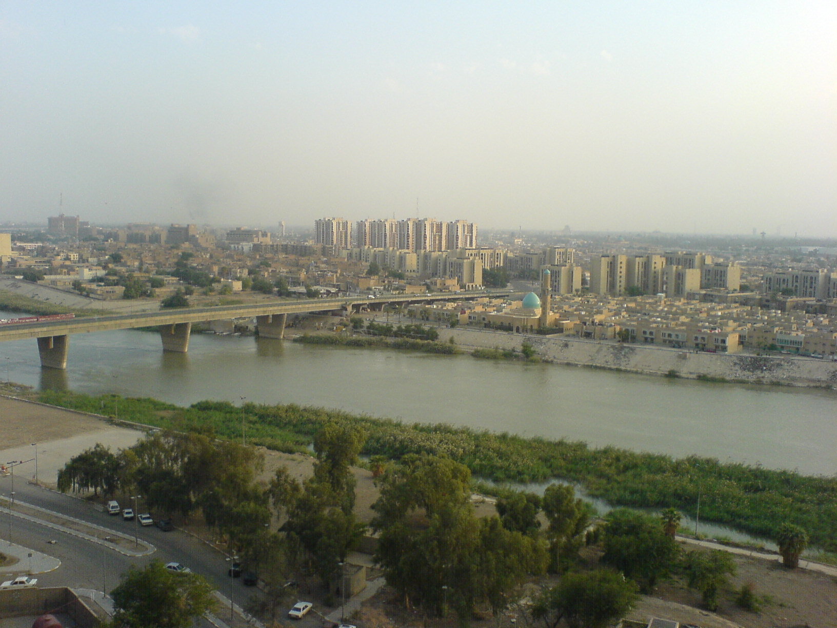
imagesize = 300px
image_caption = General view of the north-western part of Baghdad city across the Tigris, 2006.
image_
mapsize = 300px
map_caption = The location of Baghdad withinIraq .
pushpin_
pushpin_label_position =
subdivision_type =Country
subdivision_name =Iraq
subdivision_type1 = Province
subdivision_name1 =Baghdad Governorate
leader_title = Governor
leader_name =Hussein Al Tahhan
area_magnitude =
area_total_sq_mi =
area_total_km2 = 734
area_land_sq_mi =
area_land_km2 =
area_water_sq_mi =
area_water_km2 =
population_as_of = 2006
population_note = Approximate figures
population_footnotes =Estimates of total population differ substantially. TheEncyclopædia Britannica gives a 2001 population of 4,950,000, the 2006 Lancet Report states a population of 6,554,126 in 2004.
* [http://search.eb.com/eb/article-9109394 "Baghdad."] Encyclopædia Britannica. 2006. Encyclopædia Britannica Online. 13 November, 2006.
*PDFlink| [http://www.thelancet.com/webfiles/images/journals/lancet/s0140673606694919.pdf "Mortality after the 2003 invasion of Iraq: a cross-sectional cluster sample survey"] |242 KiB . By Gilbert Burnham, Riyadh Lafta, Shannon Doocy, and Les Roberts. "The Lancet ," October 11, 2006
* [http://www.globalsecurity.org/military/world/iraq/baghdad.htm Baghdad] from GlobalSecurity.org] [http://www.mongabay.com/igapo/Iraq.htm "Cities and urban areas in Iraq with population over 100,000"] , Mongabay.com]
population_total = 7000000
population_metro = 9000000
population_density_km2 = 34280
population_density_sq_mi =
timezone = GMT +3
utc_offset =
timezone_DST = +4
utc_offset_DST =
latd=33 |latm=20 |lats=00 |latNS=N
longd=44 |longm=26 |longs=00 |longEW=E
elevation_m =34
elevation_ft =
website =
footnotes =Baghdad ( _ar. بغداد"ArabDIN|Baġdād") is the
capital ofIraq and ofBaghdad Governorate , with which it is also coterminous. With a municipal population estimated at 7,000,000, it is the largest city in Iraq, and the third largest city in the Middle East afterCairo andTehran .This city of 23 square miles is located on the Tigris River. The city dates back to at least the 8th century, and probably to pre-
Islamic times. Once the center of Dar al-salam, theMuslim world , Baghdad is now important because of the ongoingIraq War .Name
Although there is no dispute over its Iranian origin, [Page 563 of the First Encyclopaedia of Islam edited by M. Th. (Martijn Theodor) Houtsma] there have been several rival proposals as to its specific etymology. The most reliable and most widely accepted among these is that the name is a
Middle Persian compound of "Bag" "god" + "dād" "given", translating to "god-given" or "God's gift", whenceModern Persian " _fa. Baɣdād". Another leading proposal is that the name comes from Middle Persian "Bāgh-dād" "The Given Garden". The name is pre-Islamic and the origins are unclear, but it is related to previous settlements, which did not have any political or commercial power, making it a virtually new foundation in the time of the Abbasids [ Encyclopaedia of Islam pg. 895 ] .Mansur called the city “Madinat as-Salam”, or “City of Peace”, as a reference to paradise [ Unus, Nada “Baghdad” ] . This was the official name on coins, weights, and other things.History
Foundation
Founding of Baghdad
Baghdad is a city within Iraq that is near the
Tigris andEuphrates Rivers. On 30 July 762 thecaliph Abu Ja'far Al-Mansur founded the city [ Times History of the World, Times Books, London 2000 ] . Mansur believed that Baghdad was the perfect city to be the capital of the Islamic empire under theAbbasids . Mansur loved the site so much he is quoted saying, “This is indeed the city that I am to found, where I am to live, and where my descendants will reign afterward". [ Wiet, Gastron. Baghdad: Metropolis of the Abbasid Caliphate. Univ. of Oklahoma Press, 1971. ] The city's growth was helped by its location, which gave it control over strategic and trading routes (along the Tigris to the sea and east-west from theMiddle East to the rest of Asia. Monthly trade fairs were also held in this area. Another reason why Baghdad provided an excellent location was due to the abundance of water and its healthy climate. Water exists on both north and south ends of the city gates, allowing all households to have a plentiful supply, which was very uncommon during this time. Baghdad reached its greatest prosperity during the reign of the caliphHarun al-Rashid in the early 9th century. Baghdad eclipsedCtesiphon , the capital of thePersian Empire , which was located some 30 km (20 miles) to the southeast, which had been under Muslim control since 637, and which became quickly deserted after the foundation of Baghdad. The site ofBabylon , which had been deserted since the 2nd century BC, lies some 90 km (55 miles) to the south.The Making of Baghdad
In its early years the city was known as a deliberate reminder of an expression in the Qu'ran, when it refers to Paradise [ Wiet, pg. 13 ] . Four years before Baghdad's foundation, in 758 Mansur assembled engineers, surveyors, and art constructionists from around the world to come together and draw up plans for the city. Over 100,000 construction workers come to survey the plans; many were distributed salaries to start the building of the grand city. The framework of the city itself is two large semicircles about twelve miles (19 km) in diameter. July was chosen as the starting time because two astronomers,
Naubaknt andMashallah , believed that the city should be built under the sign of the lion,Leo [ Wiet, pg. 12 ] . Leo is significant because he is the element of fire and symbolizes productivity, proudness, and expansion. The bricks used to make the city were 18” on all four sides.Abu Hanifa was the counter of the bricks and he developed a canal, which brought water to the work site for the use of both human consumption and the manufacturing of the bricks. Also, throughout the city marble was used to make the buildings and marble steps led down to the river’s edge. Within the city there were many parks, gardens, villas, and beautiful promenades which gave the city an elegant and classy finish [ “Yakut: Baghdad under the Abbasids, c. 1000CE” ] . The city was designed as a circle about 2 km in diameter, leading it to be known as the "Round City". The original design shows a ring of residential and commercial structures along the inside of the city walls, but the final construction added another ring, inside the first. [http://islamicceramics.ashmol.ox.ac.uk/Abbasid/baghdad.htm] In the center of the city lay the mosque, as well as headquarters for guards. The purpose or use of the remaining space in the center is unknown. The circular design of the city was a direct reflection of the traditional Persian Sasanian urban design. The ancient Sasanian city of Gur/Firouzabad is nearly identical in its general circular design, radiating avenues, and the government buildings and temples at the center of the city.The Surrounding Wall
The four surrounding walls of Baghdad were named
Kufa ,Basra , Khurasan, andSyria ; these names were given to the gates because they granted access to these destinations [ Wiet, pg. 14 ] . The distance between these gates was a little less than a mile and a half. Each gate had double doors that were made of iron, because the doors were so heavy it took several men to open and close them. The wall, itself, was about convert|145|ft|m thick at the base and about convert|39|ft|m thick at the top. Also, the wall was convert|98|ft|m high, which included themerlons , a solid part of an embattled parapet usually pierced byembrasures . This wall was surrounded by another impressive wall that consisted of convert|165|ft|m and was extremely thick. The second wall had towers and rounded merlons, which surrounded the towers. This outer wall was protected by solidglacis , which is made out of bricks andquicklime . Beyond the outer wall was a water filled moat [ Weit, pg. 14 ] .Golden Gate Palace
In the middle of Baghdad, in the central square was the Golden Gate Palace. The Palace was the residence of the caliph and his family. In the central part of the building was a green dome that was convert|160|ft|m high. On top of this dome was a horseman holding a lamp. This horseman was believed to have magical powers that leaving a mysterious presence to visitors of the caliph. Surrounding the palace was an
esplanade , a waterside building, in which only the caliph could come riding on horseback. In addition, the palace was near other mansions and officer’s residences. Near the Gate of Syria a building served as the home for the guards. It was made of brick and marble. The palace governor lived in the latter part of the building and the commander of the guards in the front. In 813, after the death of caliphAmin the palace was no longer used as the home for the caliph and his family [ Wiet, pg. 15 ] . The roundness points to the fact that it was based on Persian precedents such asFirouzabad in Persia. [See:
*cite book|title=Islam Art and Architecture|first=Markus|last=Hattstein|coauthors=Peter Delius|year=2000|pages=96|id=ISBN 3-8290-2558-0
*Encyclopedia Iranica ,Columbia University , p.413.] The two designers who were hired byal-Mansur to plan the city's design wereNaubakht , a former Persian Zoroastrian who also determined that the date of the foundation of the city would be astrologically auspicious, andMashallah , a Jew from Khorasan,Iran .cite book|title=Islamic Science and Engineering|first=Donald R.|last=Hill|year=1994|pages=10|id=ISBN 0-7486-0457-X]The Abbasids and the Round City
The Abbasid Caliphate was based on them being the descendants of the uncle of
Muhammad and being part of theQuraysh tribe. They usedShi’a resentment, Khurasanian movement, and appeals to the ambitions and traditions of the newly conquered Persian aristocracy to overthrow theUmayyads [ Atlas of the Medieval World pg. 78 ] . The Abbasids sought to combine the hegemony of the Arabic tribes with the imperial court ceremonial and administrative structures of the Persians. The Abbasids considered themselves the inheritors of two traditions: the Arabian-Islamic (bearers of the mantle of Muhammad) and the Persian (successors to theSassanid monarchs). These two things are evident from the construction, which is modeled after Persian structures and the need of Mansur to place the capital in a place that was representative of Arab-Islamic identity by building theHouse of Wisdom , where ancient texts were translated from their original language, such as Greek, to Arabic. Mansur is responsible for the “Translation Movement” for this. The Persian structures are exemplified in how the city was built: round, which is why it is called the “Round City”. It is also near the ancient Sassanid imperial seat ofCtesiphon on the Tigris River [ Atlas of the Medieval World pg. 79 ] .A center of learning (8th to 9th c.)
Within a generation of its founding, Baghdad became a hub of
learning andcommerce . TheHouse of Wisdom was an establishment dedicated to the translation of Greek,Middle Persian andSyriac works. Scholars headed to Baghdad from all over theAbbasid empire, facilitating the introduction of Greek and Indian science into the Arabic and Islamic world at that time. Baghdad was likely the largest city in the world from shortly after its foundation until the 930s, when it was tied by Córdoba. [ [http://geography.about.com/library/weekly/aa011201a.htm Largest Cities Through History ] ] Several estimates suggest that the city contained over a million inhabitants at its peak. [Matt T. Rosenberg, [http://geography.about.com/library/weekly/aa011201a.htm "Largest Cities Through History".] ] Many of the "One Thousand and One Nights " tales are set in Baghdad during this period. A portion of the population of Baghdad were non-Arabs such asPersians ,Arameans andGreeks . These communities gradually adaptedArabic language .The End of the Abbasids in Baghdad
By the 10th century, the city's population was between 300,000 and 500,000. Baghdad's early meteoric growth slowed due to troubles within the
Caliph ate, including relocations of the capital toSamarra (during 808–819 and 836–892), the loss of the western and easternmost provinces, and periods of political domination by theIran ianBuwayhid s (945–1055) andSeljuk Turks (1055–1135).The
Seljuks were a clan of theOghuz Turks from theSiberian steppes that converted to theSunni branch of Islam. In 1040, they destroyed theGhaznavids , taking over their land and in 1055,Tughril Beg , the leader of the Seljuks, took over Baghdad. The Seljuks expelled theBuyids dynasty of Shiites that ruled for some time and took over power and control of Baghdad. They ruled asSultans in the name of the Abbasid caliphs (they saw themselves as being part of the Abbasid regime) Tughril Beg saw himself as the protector of the Abbasid Caliphs [ Atlas of the Medieval World pg. 170 ] . On February 10, 1258, Baghdad was captured by theMongols led byHulegu , a grandson ofChingiz Khan during the sack of Baghdad. Many quarters were ruined by fire, siege, or looting. The Mongols massacred most of the city's inhabitants, including the caliphAl-Musta'sim , and destroyed large sections of the city. Thecanal s and dykes forming the city'sirrigation system were also destroyed. The sack of Baghdad put an end to the Abbasid Caliphate, a blow from which theIslamic civilization never fully recovered.At this point Baghdad was ruled by the
Il-Khanids , theMongol emperors ofIran . In 1401, Baghdad was again sacked, byTimur ("Tamerlane"). It became a provincial capital controlled by theJalayirid (1400–1411), Kara Koyunlu (1411–1469), Ak Koyunlu (1469–1508), and the IranianSafavid (1508–1534) dynasties.Ottoman Baghdad (16th to 19th c.)
In 1534, Baghdad was captured by the Ottoman Turks . Under the Ottomans, Baghdad fell into a period of decline, partially as a result of the enmity between its rulers and Persia, which did not accept the Turkish control of the city. Between 1623 and 1638, it was once again in Iranian hands. For a time, Baghdad had been the largest city in the
Middle East . The city saw relative revival in the latter part of the 18th century under a Mamluk government. TheNuttall Encyclopedia reports the 1907 population of Baghdad as 185,000.20th century
Baghdad and Southern Iraq were once again brought under Ottoman rule in 1638 and remained so until captured by the British during the
First World War in 1917. It became the capital of the kingdom ofIraq under British control in 1921. Iraq was given formal independence in 1932, and increased autonomy in 1946. In July 1958 the Iraqi Army staged a coup underAbdul Karim Kassem . The KingFaisal II , and his Prime MinisterNuri al-Said , amongst others, were killed.The city's population grew from an estimated 145,000 in 1900 to 580,000 in 1950 of which 140,000 wereJewish . , and sanitary infrastructure.2003 Invasion of Iraq
Baghdad was bombed very heavily in March and April 2003 in the
2003 invasion of Iraq and fell under US control byApril 7 -April 9 . Additional damage was caused by the severelooting during the days following the end of the war. With the deposition ofSaddam Hussein 's regime, the city was occupied by U.S. troops. TheCoalition Provisional Authority established a three-square-mile (8 km²) "Green Zone " within the heart of the city from which it governed Iraq during the period before the new Iraqi government was established. TheCoalition Provisional Authority ceded power to the interim government at the end of June 2004 and thereafter dissolved itself. [Rajiv Chandrasekaran, in his book "Imperial Life in the Emerald City: Inside Iraq's Green Zone (Vintage Books 2006), cites the day as June 28, 2004, at 10:00 AM, with Viceroy Bremer declaring a dissolution and presenting documents to that affect to Prime Minster Ayad Allawi two days before the announced date of June 30th. (p.329)]On
September 23 2003 , aGallup poll indicated that about two-thirds of Baghdad residents said that the removal of Hussein was worth the hardships they encountered, and that they expected a better life in five years. As time passed, however, support for the occupation declined dramatically. By April 2004, "USA Today " reported that a follow-upGallup poll in Baghdad indicated that "only 13 percent of the people now say the invasion of Iraq was morally justifiable. In the 2003 poll, more than twice that number saw it as the right thing to do." [ [http://www.usatoday.com/news/world/iraq/2004-04-28-poll-cover_x.htm USATODAY.com - Poll: Iraqis out of patience ] ]Most residents of Baghdad became impatient with the United States because essential services like
electricity were still unreliable more than a year after the invasion. In the hot summer of 2004, electricity was only available intermittently in most areas of the city. The lack of security was another pressing concern. Thecurfew imposed immediately after the invasion was lifted in the winter of 2003, but the city with a once-vibrant night life was still considered too dangerous after dark for many citizens. Those dangers includedkidnapping and the risk of being caught in fighting between security forces andinsurgent s.Fact|date=September 2007On
April 10 , 2007, theUnited States military began construction of a three mile (5 km) long, 3.5 metre tall wall around theSunni district of Baghdad. [ [http://www.guardian.co.uk/Iraq/Story/0,,2062426,00.html Latest US solution to Iraq's civil war: a three-mile (5 km) wall] ] OnApril 23 , theIraq i Prime Minister,Nouri Maliki , called for construction to be halted on the wall. [ [http://www.guardian.co.uk/Iraq/Story/0,,2063700,00.html Iraqi PM calls for halt to Baghdad wall] ] [ [http://news.bbc.co.uk/1/hi/world/middle_east/6582225.stm Iraqi PM criticises Baghdad wall] ]In 1950, 90 percent of the Baghdad's population were Sunnis Muslims. Now
Shi'ite Muslims make up 40 percent of Baghdad's population and most of the rest are Sunni. A sizeableChristian community also has a presence in Baghdad.The capital is now in the middle of a power struggle with insurgents forcing Shi'ite residents out of some areas in western Baghdad where the Sunni sect is in the majority. After the bombing of a Shi'ite shrine in
Samarra , north of Baghdad, Shi'ite militias retaliated and forced out 26,000 Sunni families from predominantly Shi'ite areas.Geography and climate
climate chart
Baghdad
3|14|20
6|17|20
10|22|20
15|28|10
20|35|0
23|40|0
25|43|0
23|42|0
21|39|0
15|32|0
8|23|20
5|16|20
source= [http://www.weatherbase.com/weather/weather.php3?s=5604&refer=&units=metric Weather Base]
float=right
clear=noneThe city is located on a vast plain bisected by theTigris River . The Tigris splits Baghdad in half, with the Eastern half being called 'Risafa ' and the Western half known as 'Karkh '. The land on which the city is built is almost entirely flat and low-lying, being of alluvial origin due to the periodic largeflood s which have occurred on the river.Baghdad has a hot
arid climate (Koppen climate classification "BWh") and is, in terms of maximum temperatures, one of the hottest cities in the world. In the summer from June to August, the average maximum temperature is as high as 44 °C (111 °F) accompanied by blazing sunshine: rainfall is almost completely unknown at this time of year. Temperatures exceeding 50 °C (122 °F) in the shade are by no means unheard of, and even at night temperatures in summer are seldom below 24 °C (75 °F) Though thehumidity is very low (usually under 10%) due to Baghdad's distance from the marshyPersian Gulf ,dust storm s from the deserts to the west are a normal occurrence during the summer.In the winter, from December to February, by contrast, Baghdad has maximum temperatures averaging 15 to 16 °C (59 to 61 °F). Minima can indeed be very cold: the average January minimum is around 4 °C (39 °F) but temperatures below 0 °C (32 °F) are not uncommon during this season.
Annual rainfall, almost entirely confined to the period from November to March, averages around 140
millimetre s (5.5 in), but has been as high as 575 millimetres (23 in) and as low as 23 millimetres (~1 in). On January 11th of 2008, light snow fell across Baghdad for the first time in memory, caused by temperatures falling below zero degrees Celsius (32 degrees Fahrenheit). [ [http://afp.google.com/article/ALeqM5huPkYk4bGVvo1Sa1tWeH-tgENiFw Afp.google.com, First snow for 100 years falls on Baghdad] ]Administrative divsions
The City of Baghdad has 89 official neighborhoods within 9 districts. These official subdivisions of the city served as administrative centers for the delivery of municipal services but until 2003 had no political function. Beginning in April 2003, the U.S. controlled Coalition Provisional Authority (CPA) began the process of creating new functions for these. The process initially focused on the election of neighborhood councils in the official neighborhoods, elected by neighborhood caucuses. CPA convened a series of meetings in each neighborhood to explain local government, to describe the caucus election process and to encourage participants to spread the word and bring friends, relatives and neighbors to subsequent meetings. Each neighborhood process ultimately ended with a final meeting where candidates for the new neighborhood councils identified themselves and asked their neighbors to vote for them. Once all 88 (later increased to 89) neighborhood councils were in place, each neighborhood council elected representatives from among their members to serve on one of the city's nine district councils. The number of neighborhood representatives on a district council is based upon the neighborhood’s population. The next step was to have each of the nine district councils elect representatives from their membership to serve on the 37 member Baghdad City Council. This three tier system of local government connected the people of Baghdad to the central government through their representatives from the neighborhood, through the district, and up to the city council.
The same process was used to provide representative councils for the other communities in Baghdad Province outside of the City itself. There, local councils were elected from 20 neighborhoods (Nahia) and these councils elected representatives from their members to serve on six district councils (Qada). As within the City, the district councils then elected representatives from among their members to serve on the 35 member Baghdad Regional Council.
The final step in the establishment of the system of local government for Baghdad Province was the election of the Baghdad Provincial Council. As before, the representatives to the Provincial Council were elected by their peers from the lower councils in numbers proportional to the population of the districts they represent. The 41 member Provincial Council took office in February, 2004 and served until National elections held in January 2005, when a new Provincial Council was elected.
This system of 127 separate councils may seem overly cumbersome but Baghdad Province is home to approximately seven million people. At the lowest level, the neighborhood councils, each council represents an average of 74,000 people.
The nine District Advisory Councils (DAC) are as follows [http://images.usatoday.com/news/graphics/troop_surge/flash.swf] :
*
Adhamiyah
*Karkh [ [http://www.defenselink.mil/news/newsarticle.aspx?id=27637 DefenseLink News Article: Soldier Helps to Form Democracy in Baghdad ] ]
*Karadah [ [http://www.defendamerica.mil/articles/june2005/a060105la2.html Zafaraniya Residents Get Water Project Update - DefendAmerica News Article ] ] [http://www.usatoday.com/news/world/iraq/2006-03-26-councils-work_x.htm]
*Kadhimyah [ [http://www.defendamerica.mil/articles/mar2004/a031804d.html DefendAmerica News - Article ] ]
*Mansour
*Sadr City (Thawra) [ [http://www.csmonitor.com/2003/1205/p01s04-woiq.html Democracy from scratch | csmonitor.com ] ]
*Rasheed [ [http://www.defendamerica.mil/articles/sept2006/a091906dg2.html Leaders Highlight Successes of Baghdad Operation - DefendAmerica News Article ] ]
*Rusafa
*New Baghdad (Tisaa Nissan) (9th of April) [ [http://www.kcentv.com/news/c-article.php?cid=5&nid=235 NBC 6 News - 1st Cav Headlines ] ]The city comprises of the following smaller neighborhoods which may make up sectors of any of the districts above. The following is a selection of neighborhoods:
*Al-
Ghazaliya
*Al-A'amiriya
*Dora
*Karrada
*Al-Jadriya
*Zayouna
*Al-Saydiya
*Hurriya City
*Al-Sa'adoon
*Al-Shu'ala
*Bab Al-Moatham
*Bab Al-Sharqi
*Al-Baya'
*Al-Za'franiya
*Hayy Ur
*Sha'ab
*Hayy Al-Jami'a
*Al-Adel
*Al Khadhraa
*Hayy Al-Jihad
*Hayy Al-A'amel
*Hayy Aoor
*Al-Horaya
*Hayy Al-Shurtta
*Yarmouk
*Al-Saydiya
*Jesr Diyala
*Abu Disher
*Raghiba Khatoun
*Arab Jijur
*Al-Awashosh
*Al-Fathel
*Al-Ubedy
*Al-Wazireya Culture
Baghdad has always played an important role in Arab cultural life and has been the home of noted writers, musicians and visual artists.
The dialect of Arabic spoken in Baghdad today differs from that of other large urban centers in Iraq, having features more characteristic of nomadic Arabic dialects (Verseegh, "The Arabic Language"). It is possible that this was caused by the repopulating of the city with rural residents after the multiple sacks of the late Middle Ages.
Institutions
Some of the important cultural institutions in the city include:
*Iraqi National Orchestra ndash Rehearsals and performances were briefly interrupted during the second Gulf War, but have since returned to normal.
*National Theatre of Iraq ndash Thetheatre was looted during the2003 Invasion of Iraq , but efforts are underway to restore the theatre. [ [http://csmonitor.com/2003/0716/p01s04b-woiq.htm Five women confront a new Iraq | csmonitor.com ] ]The live
theatre scene received a boost during the 1990s when UN sanctions limited the import of foreignfilm s. As many as 30 movie theatres were reported to have been converted to live stages, producing a wide range of comedies anddrama tic productions. [ [http://www.commondreams.org/headlines03/0102-04.htm In Baghdad, Art Thrives As War Hovers ] ]Institutions offering cultural education in Baghdad include the
Academy of Music ,Institute of Fine Arts and theMusic and Ballet school Baghdad . Baghdad is also home to a number ofmuseum s which housed artifacts and relics ofancient civilization s; many of these were stolen, and the museums looted, during the widespread chaos immediately after U.S. forces entered the city.During the
2003 occupation of Iraq ,AFN Iraq ("Freedom Radio") broadcast news and entertainment within Baghdad, among other locations. There is also a private radio station called "Dijlah" (named after the Arabic word for the Tigris River) that was created in 2004 as Iraq's first independent talk radio station. Radio Dijlah offices, in theJamia neighborhood of Baghdad, have been attacked on several occasions. [ [http://www.iht.com/articles/ap/2007/05/03/africa/ME-GEN-Iraq-Media-Attacked.php Gunmen storm independent radio station in latest attack against media in Iraq - International Herald Tribune ] ]ights and monuments
Points of interest include the
National Museum of Iraq whose priceless collection of artifacts was looted during the 2003 invasion, and the iconic Hands of Victory arches. Multiple Iraqi parties are in discussions as to whether the arches should remain as historical monuments or be dismantled. Thousands of ancient manuscripts in the National Library were destroyed when the building burnt down during the 2003 invasion of Iraq. The Al Kadhimain Shrine in the northwest of Baghdad (inKadhimiya ) is one of the most important Shi'ite religious sites in Iraq. It was finished in 1515 and the 7th (Musa ibn Jafar al-Kathim ) and the 9thImam s (Mohammad al-Jawad ) were buried there. One of the oldest buildings is the 12th century or 13th centuryAbbasid Palace . The palace is part of the central historical area of the city and close to other historically important buildings such as the Saray Building and Al-Mustansiriyah School (From the Abbasid Period). There are other landmarks in Baghdad, each of which marks a certain historical era:*
Baghdad Tower (used to be known as Saddam Tower): before its partial destruction due to the USA bombing of the Ma'amoon Telecommunication Center next to it, the tower used to be the highest point in the city and from where all Baghdad can be seen. The construction of the tower marks a period of the post-Gulf-war of 1991 reconstruction efforts.*The Two Level Bridge in Jadriyah (Jisr Abul Tabqain). Even though planing for this bridge began before Saddam's take over, the bridge was never built. As part of recent reconstruction efforts, the long planned bridge was built. It connects Al-Doura area with the rest of the Baghdad and complements the 14th of July Bridge.
*Sahat Al Tahrir (Liberation Square) downtown Baghdad.
*Saray souq
*Baghdadi Museum (wax museum)
*
Mustansiriya School , a 13th century Abbasid structure*Al-Zawra'a Park in Al-Mansour Area and almost in a central location of Baghdad.
*Kahramana and the 40 Thieves Square.
*Al Jundi Al Majhool Monument (The unknown soldier).
*
Al Shaheed Monument . Monument to the Iraqi soldiers killed in theIran–Iraq War , located on the east bank of the Tigris.*A wide road built under Saddam as a parade route, and across it is the
Hands of Victory , which is a pair of enormous crossedsword s cast from weapons of soldiers who died in theIran–Iraq War underSaddam 's command.Baghdad Zoo
The
Baghdad Zoo was the largest zoo in the Middle East. Within eight days following the 2003 invasion, however, only 35 of the 650 to 700 animals in the facility survived. This was a result of theft of some animals for human food, and starvation of caged animals that had no food or water. cite web
url=http://www.bbc.co.uk/radio4/thechoice/pip/sszoc/
title="The Choice", featuring Lawrence Anthony
publisher=BBC radio 4
date=2007-09-04 |accessdate=2007-09-04] Survivors included larger animals like bears, lions, and tigers. Notwithstanding the chaos brought by the invasion,South African Lawrence Anthony and some of the zoo keepers cared for the animals and fed the carnivoresdonkey s they had bought locally. [cite book
last=Anthony|first=Lawrence|authorlink= |coauthors= Spence Grayham
title=Babylon's Ark; The Incredible Wartime Rescue of the Baghdad Zoo
publisher= Thomas Dunne Books|date=2007-06-03|location= |pages= |url= |doi= |isbn=0312358326] Eventually, Bremer ordered protection of the zoo, and American engineers helped reopen the facility.port
Baghdad is home to some of the most successful football teams in Iraq, the biggest being
Al Quwa Al Jawiya (Airforce club),Al Zawra ,Al Shurta (Police) andAl Talaba (Students). The largest stadium in Baghdad isAl Shaab Stadium which was opened in 1966. Another. Much larger stadium, is still in the opening stages of construction.The city has also had a strong tradition of
horse racing ever sinceWorld War I , known to Baghdadis simply as 'Races'. There are reports of pressures by the Islamists to stop this tradition due to the associated gambling.Fact|date=February 2007Reconstruction efforts
Most Iraqi reconstruction efforts have been devoted to the restoration and repair of badly damaged urban infrastructure. More visible efforts at reconstruction through private development, like architect and urban designer
Hisham N. Ashkouri 's Baghdad Renaissance Plan andSindbad Hotel Complex and Conference Center . [ [http://www.arcadd.com/baghdad-cbd.htm ARCADD ] ] There are also plans to build a giant Ferris wheel akin to theLondon Eye . Iraq's Tourism Board also is seeking investors to develop a "romantic" island on the Tigris River in Baghdad that was once a popular honeymoon spot for newlywed Iraqis.The project would including a six-star hotel, spa, an 18-hole golf course and a country club. In addition, the go-ahead has been given to build numerous architecturally unique skyscrapers along the Tigris that would devlope the city's financial centre in Kadhehemiah. [ [http://www.msnbc.msn.com/id/26425911/] ]Baghdad's major streets
Source: [http://stripes.com/02/dec02/baghdad.pdf stripes.com]
*Haifa Street
*Hilla Road -- Runs from the South into Baghdad viaYarmouk (Baghdad)
*Caliphs Street -- site of historical mosques and churches.
*Sadoun Street -- stretching fromLiberation Square toMasbah
*Mohammed Al-Qassim highway nearAdhamiyah
*Abu Nuwas Street -- runs along the Tigris from the fromJumhouriya Bridge to the14 July Suspended Bridge
*Damascus Street -- goes fromDamascus Square to the International Airport Road
*Mutanabbi Street -- A street with numerous bookshops, named after the 10th century Iraqi poetAl-Mutanaby
*Rabia Street
*Arbataash Tamuz (14th July) Street (Mosul Road )
*Muthana al-Shaibani Street
*Bor Saeed (Port Said) Street
*Thawra Street
*Al Qanat Street -- runs through Baghdad north-south
*Al Khat al Sare'a - Mohammed al Qasim (High Speed lane) - runs through bagdhad, north -south
*Al Sinaa Street (Industry St.) runs by the University of Technology - center of computers trade in Baghdad.
*Al Nidhal Street
*Al Rasheed Street -- Downtown Baghdad
*Al Jamhuriah Street -- Downtown Baghdad
*Falastin (Palestine) Street
*Tariq el Muaskar -- (Al Rasheed Camp Road)
*Matar Baghdad Al-Dawli (Airport Road) Town twinning (sister cities)
ee also
*
Reconstruction of Iraq
*List of places in Iraq
*Firdus Square
*Baghdad Arabic
*Baghdad Airport Road
*Baghdad bridge stampede
*Baghdad Security Plan
*Reconstruction of Iraq
*Baghdad Renaissance Plan
*Sindbad Hotel Complex and Conference Center References
Further reading
* [http://fax.libs.uga.edu/DS49x2xW684B/ By Desert Ways to Baghdad] , by Louisa Jebb (Mrs. Roland Wilkins), 1908 (1909 ed) "(a searchable facsimile at the University of Georgia Libraries;
DjVu & PDFlink| [http://fax.libs.uga.edu/DS49x2xW684B/1f/desert_ways_to_baghdad.pdf layered PDF] |11.3 MiB format)"
* [http://fax.libs.uga.edu/DS49x2xM465D/ A Dweller in Mesopotamia] , being the adventures of an official artist in the garden of Eden, by Donald Maxwell, 1921 "(a searchable facsimile at the University of Georgia Libraries;DjVu & PDFlink| [http://fax.libs.uga.edu/DS49x2xM465D/1f/dweller_in_mesopotamia.pdf layered PDF] |7.53 MiB format)"External links
* [http://www.au.af.mil/au/awc/awcgate/iraq/baghdadmapb.jpgMap of Baghdad]
* [http://memory.loc.gov/cgi-bin/map_item.pl?style=plnews&data=/gmtemp/news/ni000001.sid&title=Baghdad,+2003 Interactive map]
* [http://countrystudies.us/iraq/42.htm Iraq - Urban Society]
* [http://www.usatoday.com/money/world/2004-03-01-hisham_x.htm Envisioning Reconstruction In Iraq]
* [http://archnet.org/library/sites/one-site.tcl?site_id=7592 Description of the original layout of Baghdad]
* [http://healingiraq.blogspot.com/baghdadethno1.jpgEthnic and sectarian map of Baghdad - Healingiraq]
* [http://www.arcadd.com/baghdad-cbd.htm Baghdad Renaissance Plan]
* [http://www.iraqieconomy.org/home/bilecon/uae/2004.09.23 UAE Investors Keen On Taking Part In Baghdad Renaissance Project]
* [http://www.tufts.edu/home/feature/?p=ashkouri Man With A Plan: Hisham Ashkouri]
* [http://www.arcadd.com/scholastic-article.htm Renaissance Plan In The News]
* [http://www.arcadd.com ARCADD, Inc.]
* [http://www.cityoflight-kabul.com/index.htm Kabul, City of Light Development]
* [http://www.cityoflight-kabul.com/index.htm Kabul - City of Light, 9 Billion dollar modern urban development project]
* [http://www.cinemasindbad.com Sindbad Hotel Complex and Conference Center]
* [http://www.musicsa.com.au/artists/media/music/Track%203%20-%20Birds%20Over%20Baghdad.mp3 Song - Birds Over Baghdad]
* [http://baghdadtreasure.blogspot.com Baghdad Treasure]
* [http://riverbendblog.blogspot.com Baghdad Burning Riverbend]
* [http://electroniciraq.net Electronic Iraq]Template group
list =
Wikimedia Foundation. 2010.