- Marsworth
-
Coordinates: 51°49′21″N 0°39′58″W / 51.8225°N 0.6661°W
Marsworth 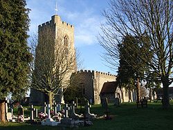
All Saints Church, Marsworth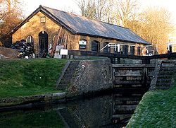
Marsworth Top Lock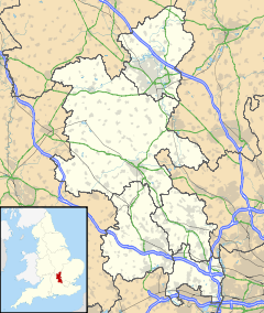
 Marsworth
Marsworth shown within BuckinghamshirePopulation 801 [1] OS grid reference SP920145 District Aylesbury Vale Shire county Buckinghamshire Region South East Country England Sovereign state United Kingdom Post town TRING Postcode district HP23 Dialling code 01296 Police Thames Valley Fire Buckinghamshire Ambulance South Central EU Parliament South East England List of places: UK • England • Buckinghamshire - For the nearby reservoir, see Marsworth reservoir
Marsworth is a village and also a civil parish within Aylesbury Vale district in Buckinghamshire, England. It is about two miles north of Tring, in Hertfordshire and six miles east of Aylesbury.
Contents
Early history
The village name is Anglo Saxon in origin, Mæssanwyrth, and means 'Mæssa's enclosure'. Marsworth is first mentioned in the will of Aelfgyfu (before 975) as granted to Edgar of England who in turn passed it to St Etheldreda's Church belonging to the Bishops of Ely. Brictric, a thegn of Edward the Confessor. After the Norman Conquest Marsworth (Missevorde) is recorded in the Domesday Book as in the possession of Robert D'Oyly and was connected to Wallingford, an association which continued into the 17th century. The tenants at this time were the Bassett family and the land was split between six sisters and through their line the estates passed to the Goldingtons at which time the manor becomes recorded as Marsworth with Goldringtons.
By 1319 records show there were still several overlords controlling various parts of Marsworth including a descendant of Isabel Bassett, John de Beauchamp Lord of the Manor at Hawridge. This is the first indication of a tie-up between Marsworth and the detached manor or Hawridge, possibly to provide woodland and hilltop summer pasture for the estate across the narrow isthmus of Hertfordshire.
There were connections between another estate in Marsworth and the Savoy Hospitalin London whom the Boughton family granted lands in 1514 in the honour of Henry III. It subsequently became an endowment for St Thomas's Hospital and in 1876 was swapped for lands in Essex by William Brown of Tring.
There are records of a church in Marsworth since the 12th century. All Saints Church was further extended in the 14th and 15th centuries. Despite further restoration in the first part of the 19th century by 1880 the church was in a deplorable condition and the newly appointed vicar, the Rev. F. W. Ragg set about with the help of parishioners to restore it over the next 25 years.
Marsworth today
The construction of the Grand Union Canal, which passes through this village brought with it many new business opportunities and the village expanded greatly as a result. Within the parish boundary of Marsworth, to the south of the main village where the canal cross the Lower Icknield Way is the hamlet of Startop's End. In 2010 the during building work engineers dug up over 40 bodies in un-marked graves which were subsequesntly interred in a ceremony conducted by the vicar.[citation needed]
Nearby are three of the four Tring reservoirs, one of which is named Marsworth reservoir.
References
External links
Categories:- Villages in Buckinghamshire
- Civil parishes in Buckinghamshire


Wikimedia Foundation. 2010.