Calcareous grassland

Calcareous grassland

Calcareous grassland (or alkaline grassland) is an ecosystem associated with thin basic soil, such as that on chalk and limestone downland.[1] Plants on calcareous grassland are typically short and hardy, and include grasses and herbs such as clover. Calcareous grassland is an important habitat for insects, particularly butterflies, and is kept at a plagioclimax by grazing animals, usually sheep and sometimes cattle. Rabbits used to play a part but due to the onset of Myxomatosis their numbers decreased so dramatically that they no longer have much of a grazing effect.

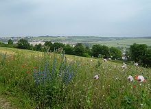
Ranscombe Farm, Medway on the North Downs. In June, these meadows are covered with chalk grassland flowers.

There are large areas of calcareous grassland in northwestern Europe, particularly areas of southern England, such as Salisbury Plain and the North and South Downs.

The machair forms a different kind of calcareous grassland, where fertile low-lying plains are formed on ground that is calcium-rich due to shell sand (pulverised sea shells).

See also

Notes

  1. ^ Chalk Grassland HAP

References

  • Gibson, C.W.D. (1995). Chalk grasslands on former arable land: a review. Bioscan (UK) Ltd, Oxford.
  • Gibson, C.W.D. & Brown, V.K. (1991). The nature and rate of development of calcareous grassland in southern Britain. Biological Conservation, 58, 297-316.
  • Hillier, S.H., Walton, D.W.H. & Wells, D.A. (Eds.) (1990). Calcareous grasslands - ecology and management. Bluntisham, Huntingdon.
  • Price, Elizabeth (2002), Grassland and heathland habitats, New York: Routledge, pp. 208, ISBN 0415187621 
  • Smith, C.J. (1980). The Ecology of the English Chalk. Academic Press, London.

Wikimedia Foundation. 2010.

Игры ⚽ Нужна курсовая?

Look at other dictionaries:

  • Grassland — This article is about vegetation and landscape. For other uses, see Grassland (disambiguation). Greensward redirects here. For park plan, see Central Park …   Wikipedia

  • Mendip Hills — Coordinates: 51°18′N 2°44′W / 51.3°N 2.733°W / 51.3; 2.733 …   Wikipedia

  • Crook Peak to Shute Shelve Hill — Site of Special Scientific Interest …   Wikipedia

  • Downland — Culver Down, Isle of Wight. A downland is an area of open chalk hills. This term is especially used to describe the chalk countryside in southern England. Areas of downland are often referred to as Downs. The word down derives from a medieval… …   Wikipedia

  • Beacon Hill, Warnford, Hampshire — There are two hills in Hampshire called Beacon Hill; the other one is near BurghclereBeacon Hill, Warnford, Hampshire is a chalk hill in the South Downs on the boundary of the parishes of Warnford and Exton. Part of the hill is a National Nature… …   Wikipedia

  • Cheddar — This article is about the settlement in Somerset, England. For the cheese, see Cheddar cheese. For other uses, see Cheddar (disambiguation). Coordinates …   Wikipedia

  • Marsh Fritillary — Euphydryas aurinia, northern Portugal Scientific classification Kingdom: Animalia …   Wikipedia

  • Boho, County Fermanagh — Infobox Irish Place|thumb|left|name = Boho irish = Botha map pin coords = north coord = | west coord = province = Ulster county = County Fermanagh NI district = Fermanagh UK constituency = Fermanagh and South Tyrone stdcode = 028, +44 28 posttown …   Wikipedia

  • Draycott Sleights — Site of Special Scientific Interest …   Wikipedia

  • Folkestone Downs — Infobox SSSI name=Folkestone To Etchinghill escarpment aos=Kent interest=Biological and Geological gridref=TR171394 to TR235376 area=269.5 hectares notifydate=1951 http://www.natureonthemap.org.uk/map.aspx Natural England ] The Folkestone Downs… …   Wikipedia

Share the article and excerpts

Direct link
Do a right-click on the link above
and select “Copy Link”