- Mount Signal, California
-
Coordinates: 32°40′42″N 115°38′21″W / 32.67833°N 115.63917°W
Mount Signal — Unincorporated community — Location in California
 Mount Signal
Coordinates: 32°40′42″N 115°38′21″W / 32.67833°N 115.63917°W Country United States State California County Imperial County Elevation[1] -13 ft (-4 m) Mount Signal is an unincorporated community located along State Route 98 about 7.5 miles (12.1 km) west of Calexico in the southern part of the Imperial Valley in Imperial County, California. The area is south of Interstate 8 and about 1.7 miles (2.7 km) north of the Mexico border. It lies at an elevation of 13 feet (4 m) below sea level.[1] This is an agricultural area. There are a few homes and businesses and many irrigation canals and green fields. Other nearby communities include Heber, El Centro, and Seeley.
The ZIP Code for Mount Signal is 92231 and the area is in Calexico's telephone exchange area. Its area code is 760. While not a Census Designated Place, the name is official and it does have a National Geographic Names Database feature ID of 1661068. The official U.S. Geological Survey coordinates are 32°40′42″N 115°38′21″W / 32.67833°N 115.63917°W: this defines a spot near the intersection of State Route 98 (SR98) and Brockman Road.
Contents
Name
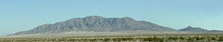
The community is named for Mount Signal, a summit about 5.5 miles (8.9 km) southwest, inside Mexico. It is also known as El Cerro Centinela, by the Mexicans, and Wi'Shspa, by the Kwapa: Cocopah people.
Mount Signal was used by the early Pioneers and Native Americans as a landmark to help guide them through the desert. Most of the fields in the area are currently growing alfalfa or sugar beets. On a clear winter morning, Mount Signal appears to leap into the scenic foreground making for a spectacular view.
Mount Signal Road takes you to the mountain and the International Border. Unfortunately, there is not a Port of Entry there. However, there is a limited access area for off-road vehicles.
Even though Mount Signal appears to be in the United States, it is actually located on the Mexican side of the border. If one would like to climb all 2,300 feet (700 m) to the top, one must do so from the Mexican side. Climbers need to take care, there are no maintained trails. During the 1870s U.S. engineers climbed the mountain to record the elevation, so there should be a monument marker at the top.
History
A post office operated at Mount Signal from 1916 to 1934.[2]
Points of interest
Other geographic features supporting the name include Mount Signal School, feature ID of 246276. It is believed the school no longer exists; its location was one mile (1.6 km) north of these coordinates on Brockman Road.
At the intersection of SR98 and Brockman Road is the Mount Signal Café, currently closed. The business was shown on an episode of "California's Gold".
Politics
In the state legislature Mount Signal is located in the 40th Senate District, represented by Democrat Denise Moreno Ducheny, and in the 80th Assembly District, represented by Republican Bonnie Garcia. Federally, Mount Signal is located in California's 51st congressional district, which has a Cook PVI of D +7[3] and is represented by Democrat Bob Filner.
References
- ^ a b U.S. Geological Survey Geographic Names Information System: Mount Signal, California
- ^ Durham, David L. (1998). California's Geographic Names: A Gazetteer of Historic and Modern Names of the State. Quill Driver Books. p. 1447. ISBN 9781884995149.
- ^ "Will Gerrymandered Districts Stem the Wave of Voter Unrest?". Campaign Legal Center Blog. http://www.clcblog.org/blog_item-85.html. Retrieved 2007-10-20.
External links
- One hundred and One Views of Mount Signal, maintained by American Artist Allan McCollum
- Map: "Mount Signal, California," 7.5-minute quadrangle, U.S. Geological Survey, 1976.
- California's Gold, Huell Howser Productions, (unknown episode, #302?)
- Map: "Imperial County," Automobile Club of Southern California, 1997.
Municipalities and communities of Imperial County, California County seat: El Centro Cities Brawley | Calexico | Calipatria | El Centro | Holtville | Imperial | Westmorland

CDPs Bombay Beach | Desert Shores | Heber | Niland | Ocotillo | Palo Verde | Salton City | Salton Sea Beach | Seeley | Winterhaven
Unincorporated
communitiesAcolita | Alamorio | Amos | Andrade | Anza | Araz Junction | Bard | Bertram | Bonds Corner | Boulder Park | Cactus | Citrus View | Clyde | Coolidge Springs | Coyote Wells | Curlew | Date City | Dixieland | Dunes | Edgar | Elmore Desert Ranch | Estelle | Felicity | Fondo | Frink | Fuller | Glamis | Gordons Well | Hovley | Imperial Gables | Iris | Kane Spring | Meloland | Mesquite | Moss | Mount Signal | Mundo | Munyon | Obregon | Ogilby | Orita | Paymaster Landing | Perrys Corner | Picacho | Plaster City | Pope | Rico | Rockwood | Ross Corner | Ruthven | Sandia | Slab City | Tortuga | Truckhaven | Verdant | Watermans Corner | Wiest | Wilsie | Wister
Indian
reservationsFort Yuma Indian Reservation | Torres-Martinez Indian Reservation
Ghost towns Araz | Barnes | Bernice | Bradtmoore | Butlers | Colorado | Concepcíon | Eastside | Gleason | Hazelwood | Highline | Indian Wells | Keystone | Laguna | Laparra | Lano | Mayflower | Mobile | No Mirage | Paringa | Picacho Basin | Potholes | Sackett's Wells | Sellew | Shamrock | Silsbee | Squeaky Springs
Categories:- Populated places in the Colorado Desert
- Unincorporated communities in Imperial County, California


Wikimedia Foundation. 2010.