- Milnsbridge
-
Coordinates: 53°38′29″N 1°49′34″W / 53.641288°N 1.826171°W
Milnsbridge 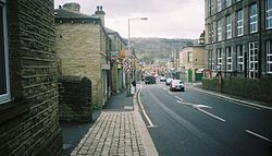
Market Street, Milnsbridge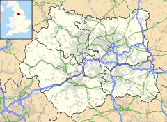
 Milnsbridge
Milnsbridge shown within West YorkshireOS grid reference SE1159016100 Metropolitan borough Kirklees Metropolitan county West Yorkshire Region Yorkshire and the Humber Country England Sovereign state United Kingdom Post town HUDDERSFIELD Postcode district HD3 Dialling code 01484 Police West Yorkshire Fire West Yorkshire Ambulance Yorkshire EU Parliament Yorkshire and the Humber UK Parliament Colne Valley List of places: UK • England • Yorkshire Milnsbridge is a district of Huddersfield, West Yorkshire, England 2.5 miles (4 km) west of the town centre, situated in the Colne Valley. The name is said to have derived from the water-powered mill and the bridge that stood alongside it in the 13th century.
The Huddersfield Narrow Canal runs through Milnsbridge close to the River Colne. A viaduct carries the trans-Pennine Huddersfield Line railway that runs through Milnsbridge, and links Leeds and Manchester via Huddersfield. The Huddersfield to Manchester road route A62 passes Milnsbridge along the south side of the valley.
Until recent times Milnsbridge was mostly centred on the woollen and worsted yarn textile industry, with mills situated along the riverside. These formerly relied on the river and the Canal. There is less evidence of this industry than there was, as most of the mill chimneys were removed when the mills were demolished or converted into housing. However, there are still many streets of 19th century terraced houses in the area; these were originally built as mill workers' houses.
Britannia Mills is well known for the manufacturing, by Arthur Quarmby & Son, of pub-related items such as beer mats, mirrors and clocks.
Jack Ramsay in his book "Made in Huddersfield" describes Milnsbridge in 1989:
“ ...for my own beliefs about the devastation and subsequent run-down feel of Milnsbridge are rooted in the very substance of the town's visual character, which is seen as being especially gloomy in the eyes of many local residents because the place is situated in the belly of the [Colne] valley and which has the psychological effect of making it appear somewhere rather morbid and inaccessible like a steelworks crowding the bottom of a hillside city. ” Milnsbridge spreads from Cowlersley - on the other side of the A62 Manchester Road - to Golcar, Longwood and Paddock. Since the demolition of the school on New Street (with its swimming pool) the main primary school in Milnsbridge has been Crow Lane School, with 11-18s either attending Royds Hall School, Salendine Nook High, All Saints Catholic High or Colne Valley High in Linthwaite. At the centre of Milnsbridge is the Baptist Church (founded 150 years ago, but rebuilt in 2004).
Books
- Ramsay, Jack (1989) Made in Huddersfield ISBN 978-1-871939-00-2
External links
- Milnsbridge.org website
- A night at the circus? A circus visit to Milnsbridge in 1891, pieced together from details in the census of that year. BBC Bradford and West Yorkshire, retrieved 12 December 2006.
Categories:- Geography of Huddersfield
- Kirklees
- Colne Valley


Wikimedia Foundation. 2010.