- Oroville Municipal Airport
-
Oroville Municipal Airport 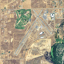
2006 USGS Orthopthoto IATA: OVE – ICAO: KOVE Summary Airport type Public Operator City of Oroville Location Oroville, California Elevation AMSL 192 ft / 58.5 m Coordinates 39°29′16.20″N 121°37′19.20″W / 39.487833°N 121.622°WCoordinates: 39°29′16.20″N 121°37′19.20″W / 39.487833°N 121.622°W Runways Direction Length Surface ft m 1/19 6,020 1,835 Asphalt 12/30 3,540 1,079 Asphalt Oroville Municipal Airport (IATA: OVE, ICAO: KOVE) is a public airport located 3 miles (5 km) southwest of the city of Oroville in Butte County, California, USA.
Contents
Facilities
Oroville Municipal Airport covers 920 acres (3.7 km2) and has two runways:
- Runway 1/19: 6,020 x 100 ft (1,835 x 30 m), Surface: Asphalt
- Runway 12/30: 3,540 x 100 ft (1,079 x 30 m), Surface: Asphalt
Table Mountain Aviation is part of the Oroville Municipal Airport, which lies approximately 3 miles (4.8 km) southwest of downtown.
The airport has two runways: Runway 1-19 (6,020 feet long and 100 feet wide) and Runway 12-30 (3,540 feet long and 100 feet wide). The runway system is anchored by three major parallel taxiways:
- Taxiway A is a full-length 60-foot-wide taxiway (18 m) located on the east side of Runway 1-19
- Taxiway J is a full-length 40-foot-wide taxiway (12 m) located on the west side of Runway 12-30
- Taxiway R is a full-length 70-foot-wide taxiway (21 m) located on the east side of Runway 12-30
Three main apron areas exist on the airfield. The largest apron area is located around the Table Mountain Aviation FBO buildings. The FBO apron area is home to 38 tie-downs as well as the fuel tanks and provides access to Taxiway R to the west of the apron and Taxiway S to the north of the apron. The second largest apron area is located in the midfield area of the airfield, south of Runway 19. This apron area is home to 76 tie downs. The third apron area is located east of the Table Mountain Golf Course and provides space for 5 tie downs, and is ideal for golfers that fly to the Airport. For more information, visit the website: http://www.tablemountainaviation.com/
History
In 1936, the City of Oroville acquired 188 acres (0.76 km2) of grazing land for use as a municipal airport. During 1941, the city and the Works Project Administration (WPA) extended the runways and increased the total airport land area to 428 acres (1.73 km2).
In 1942, the War Department leased the Oroville Municipal Airport and renamed it Oroville Army Air Field (AAF). That same year the Army purchased an additional 381.98 acres (1.5458 km2) of land for expansion of the field and construction of a cantonement area. Once operational, it served as a fighter group training installation from spring of 1943 through early summer 1944. Two fighter groups rotated through Oroville AAF: the 357th Fighter Group (fighter group of famed pilots Chuck Yeager and Bud Anderson) and the 369th Fighter Group. Aircraft present at the field were identified as the Bell P-39Q Airacobra, North American P-51B/C/D Mustangs, and possibly the North American A-36 Apache, the ground attack version of the P-51.
Layout plans of the former Oroville AAF dated 1944 indicate a Bomb Storage Area west of the two runways and a skeet range between the southern extents of the runways. Fueling pit boxes were located along former Taxiways A (running parallel to runway 12/30) and C (connecting the southernmost ends of runways 1/19 and 12/30). A 1947 Inventory Report of Buildings and Structures states that bombs were stored in earth revetments.
In 1945 Oroville AAF was listed as “temporarily inactive” under assignment to Air Technical Service Command and was later classified as surplus. In 1946 the War Assets Administration (WAA) assumed custody of the site and on 21 May 1947, the WAA terminated the U.S. Army’s lease with the City of Oroville and returned ownership to civil authorities.
See also
External links
- City of Oroville: Oroville Municipal Airport
- Resources for this airport:
- AirNav airport information for KOVE
- ASN accident history for OVE
- FlightAware airport information and live flight tracker
- NOAA/NWS latest weather observations
- SkyVector aeronautical chart, Terminal Procedures for KOVE
Airfields Group Training Stations · Replacement Training Stations · Tactical Airfields
Units Commands IV Bomber Command · IV Fighter Command · IV Air Support CommandWings 21st Bombardment · Los Angeles Fighter · San Diego Fighter · San Francisco Fighter · Seattle FighterGroups Bombardment 12th Bombardment · 30th Bombardment · 41st Bombardment · 42d Bombardment · 47th Bombardment · 380th Bombardment · 385th Bombardment · 389th Bombardment · 392d Bombardment · 399th Bombardment · 449th Bombardment · 450th Bombardment · 451st Bombardment · 453rd Bombardment · 454th Bombardment · 455th Bombardment · 456th Bombardment · 461st Bombardment · 463d Bombardment · 465th Bombardment · 466th Bombardment · 470th Bombardment · 483rd Bombardment · 486th Bombardment · 491st Bombardment · 492d BombardmentFighter 1st Fighter · 14th Fighter · 20th Fighter · 35th Fighter · 51st Fighter · 55th Fighter · 78th Fighter · 81st Fighter · 82d Fighter · 328th Fighter · 329th Fighter · 339th Fighter · 354th Fighter · 360th Fighter · 363rd Fighter · 364th Fighter · 369th Fighter · 367th Fighter · 372d Fighter · 412th Fighter · 473d Fighter · 474th Fighter · 478th Fighter · 479th FighterReconnaissance 68th Reconnaissance · 69th ReconnaissanceTroop Carrier Categories:- Oroville, California
- Airports in Butte County, California
- Airfields of the United States Army Air Forces in California
- USAAF Fourth Air Force Group Training Stations


Wikimedia Foundation. 2010.