- National Register of Historic Places listings in Kent County, Delaware
-
List of the National Register of Historic Places listings in Kent County, Delaware
-
- This National Park Service list is complete through NPS recent listings posted November 10, 2011.[1]
Contents: Counties in Delaware
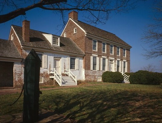
Kent - New Castle - Sussex [2] Landmark name Image Date listed Location City or town Summary 1 Allee House 
March 24, 1971 Off Delaware Route 9 on Dutch Neck Rd.
39°17′05″N 75°30′32″W / 39.284722°N 75.508889°WDutch Neck Crossroads 2 Archeological Site K-875 (7K-D-37/C) May 22, 1979 Address restricted Kitts Hummock 3 Archeological Site K-873 (7K-D-35/A, B and D) May 22, 1979 Address restricted Magnolia 4 Archeological Site K-876 (7K-D-38/C) May 22, 1979 Address restricted Kitts Hummock 5 Archeological Site K-880 (7K-D-42/F) May 22, 1979 Address restricted Magnolia 6 Archeological Site K-891 (7K-D-45/A and B) May 22, 1979 Address restricted Magnolia 7 Archeological Site K-913 (7K-D-47/C, D and E) May 22, 1979 Address restricted Kitts Hummock 8 Archeological Site K-914 (7K-D-48/F and G) May 22, 1979 Address restricted Kitts Hummock 9 Archeological Site K-915 (7K-D-86/C) May 22, 1979 Address restricted Kitts Hummock 10 Archeological Site K-916 (7K-D-49/C) May 22, 1979 Address restricted Kitts Hummock 11 Archeological Site K-920 (7K-D-52/A and C) May 22, 1979 Address restricted Kitts Hummock 12 Archeological Site No. 7K F 4 and 23 June 3, 1982 Address restricted Milford 13 George Arnold House June 27, 1983 Delaware Route 42
39°12′46″N 75°39′20″W / 39.212778°N 75.655556°WKenton 14 Aspendale 
April 15, 1970 1 mile west of Kenton on Delaware Route 300
39°13′18″N 75°41′09″W / 39.221667°N 75.685833°WKenton 15 Thomas Attix House June 27, 1983 County Road 140
39°13′31″N 75°42′28″W / 39.225278°N 75.707778°WKenton 16 Bank House July 31, 1978 119 N. Walnut St.
38°54′55″N 75°25′43″W / 38.915278°N 75.428611°WMilford 17 Bannister Hall and Baynard House April 11, 1973 South of Smyrna off Delaware Route 300
39°17′22″N 75°37′19″W / 39.289444°N 75.621944°WSmyrna 18 Barratt Hall April 13, 1973 South of Frederica off County Road 372
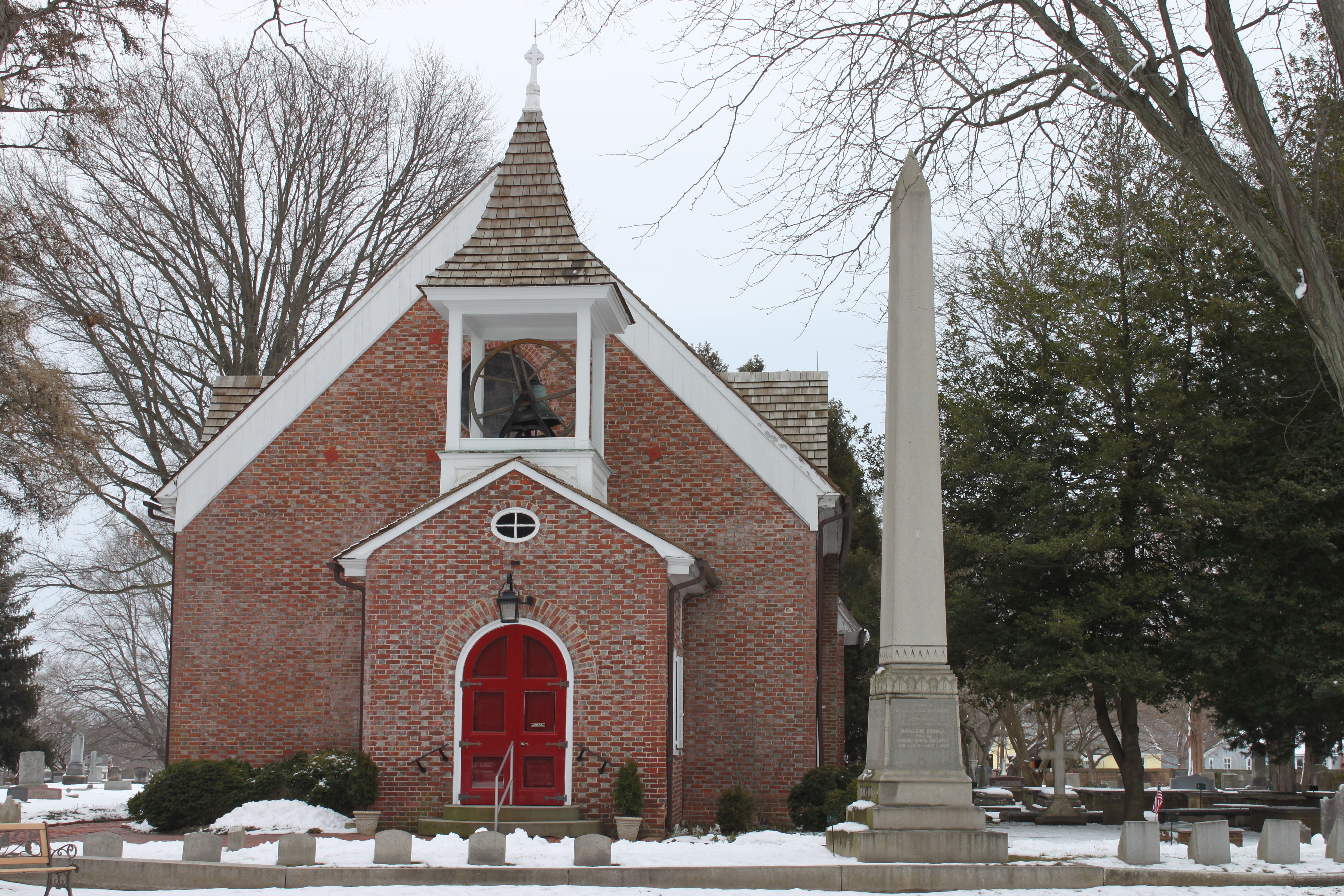
39°01′29″N 75°26′24″W / 39.024722°N 75.44°WFrederica 19 Barratt's Chapel 
October 10, 1972 North of Frederica on Delaware Route 1
39°01′29″N 75°27′34″W / 39.024722°N 75.459444°WFrederica 20 Belmont Hall 
December 16, 1971 1 mile south of Smyrna on U.S. Route 13
39°17′40″N 75°35′46″W / 39.294444°N 75.596111°WSmyrna 21 Bethel Methodist Protestant Church September 14, 1998 Junction of County Roads 61, 114, and 304
38°51′49″N 75°38′13″W / 38.863611°N 75.636944°WAndrewsville 22 J. F. Betz House August 29, 1983 Delaware Route 6
39°17′02″N 75°40′29″W / 39.283889°N 75.674722°WKenton 23 Benjamin Blackiston House June 27, 1983 Off Delaware Route 6
39°15′07″N 75°44′13″W / 39.251944°N 75.736944°WKenton 24 Bonwell House March 20, 1973 4 miles west of Frederica on County Road 380
39°01′23″N 75°30′34″W / 39.023056°N 75.509444°WFrederica 25 Bradford-Loockerman House 
November 30, 1972 419 S. State St.
39°09′19″N 75°31′24″W / 39.155278°N 75.523333°WDover 26 Brecknock December 24, 1974 0.5 miles north of Camden off U.S. Route 13
39°07′26″N 75°32′10″W / 39.123889°N 75.536111°WCamden 27 Building 1301, Dover Air Force Base 
December 7, 1994 Dover AFB, E. Dover Hundred Dover 28 John Bullen House 
April 14, 1975 214 S. State St.
39°09′28″N 75°31′29″W / 39.157778°N 75.524722°WDover 29 W. D. Burrows House June 27, 1983 Delaware Route 42
39°14′10″N 75°40′30″W / 39.236111°N 75.675°WKenton 30 Byfield Historic District May 22, 1979 Address restricted Kitts Humock 31 Byrd's AME Church October 19, 1982 Smyrna Ave.
39°17′32″N 75°37′38″W / 39.292222°N 75.627222°WClayton 32 Camden Friends Meetinghouse 
April 3, 1973 Commerce St.
39°06′52″N 75°32′54″W / 39.114444°N 75.548333°WCamden 33 Camden Historic District September 17, 1974 Both sides of Camden-Wyoming Ave. and Main St.
39°06′49″N 75°32′34″W / 39.113611°N 75.542778°WCamden 34 Carey Farm Site October 20, 1977 Address restricted Dover 35 Cherbourg Round Barn December 22, 1978 Southwest of Little Creek off Delaware Route 9
39°09′04″N 75°27′27″W / 39.151111°N 75.4575°WLittle Creek 36 Scene of Cheyney Clow's Rebellion January 14, 1974 West of Kenton on Delaware Route 300
39°12′15″N 75°44′35″W / 39.204167°N 75.743056°WKenton 37 Christ Church May 8, 1973 3rd and Church Sts.
38°54′56″N 75°25′55″W / 38.915556°N 75.431944°WMilford 38 Christ Church 
December 4, 1972 S. State and Water Sts.
39°09′16″N 75°31′20″W / 39.154444°N 75.522222°WDover 39 Clark-Pratt House June 27, 1983 Main St.
39°13′34″N 75°40′39″W / 39.226111°N 75.6775°WKenton 40 Clayton Railroad Station November 6, 1986 Bassett St.
39°17′28″N 75°38′00″W / 39.291111°N 75.633333°WClayton 41 Coombe Historic District April 8, 1982 West of Felton on Delaware Route 12 and County Road 281
39°00′09″N 75°37′10″W / 39.0025°N 75.619444°WFelton 42 Cooper House March 20, 1973 Delaware Route 300
39°13′40″N 75°39′49″W / 39.227778°N 75.663611°WKenton 43 Thomas B. Coursey House July 23, 1990 County Road 388 north of Coursey Pond
38°59′27″N 75°30′42″W / 38.990833°N 75.511667°WFelton 44 Cow Marsh Old School Baptist Church June 24, 1976 Northeast of Sandtown on Delaware Route 10
39°02′31″N 75°41′42″W / 39.041944°N 75.695°WSandtown 45 David J. Cummins House October 6, 1983 East of Smyrna
39°17′20″N 75°34′18″W / 39.288889°N 75.571667°WSmyrna 46 Timothy Cummins House October 6, 1983 East of Smyrna
39°16′44″N 75°32′25″W / 39.278889°N 75.540278°WSmyrna 47 Thomas Davis House February 28, 1983 Delaware Route 6
39°17′15″N 75°39′26″W / 39.2875°N 75.657222°WKenton 48 Delaware Boundary Markers February 18, 1975 Maryland and Pennsylvania state boundary lines Not applicable 49 Delaware State Museum Buildings 
February 1, 1972 316 S. Governors Ave.
39°09′22″N 75°31′39″W / 39.156111°N 75.5275°WDover 50 T.H. Denny House June 27, 1983 Delaware Route 42
39°12′42″N 75°36′25″W / 39.211667°N 75.606944°WKenton 51 John Dickinson House 
October 15, 1966 5 miles southeast of Dover and 3 miles east of U.S. Route 13 on Kitts Hummock Rd.
39°06′09″N 75°26′55″W / 39.1025°N 75.448611°WDover 52 Dill Farm Site October 2, 1978 Address restricted Sandtown 53 Dover Green Historic District 
May 5, 1977 Bounded by Governors Ave., North, South, and East Sts.
39°09′17″N 75°31′26″W / 39.154722°N 75.523889°WDover 54 N. C. Downs House June 27, 1983 County Road 141
39°14′04″N 75°42′03″W / 39.234444°N 75.700833°WKenton 55 Duck Creek Village February 1, 1972 County Road 65 between Duck Creek and Green's Branch
39°18′28″N 75°37′15″W / 39.307778°N 75.620833°WSmyrna 56 Durham-Shores House September 21, 2001 Eastern side of Delaware Route 15
39°11′46″N 75°33′49″W / 39.196111°N 75.563611°WDupont Station 57 Eden Hill May 8, 1973 Western end of Water St.
39°09′05″N 75°32′13″W / 39.151389°N 75.536944°WDover 58 Felton Historic District January 26, 1988 Roughly bounded by North, Walnut, Main, and Niles Sts.
39°00′27″N 75°34′56″W / 39.0075°N 75.582222°WFelton 59 Felton Railroad Station July 13, 1981 E. Railroad Ave.
39°00′38″N 75°34′35″W / 39.010556°N 75.576389°WFelton 60 Fennimore Store May 24, 1982 Main, Lombard, and Front Sts.
39°14′27″N 75°30′51″W / 39.240833°N 75.514167°WLeipsic 61 Fourteen Foot Bank Light 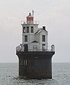
March 27, 1989 On Fourteen Foot Bank in Delaware Bay, 12 miles east of Bowers
39°02′54″N 75°10′57″W / 39.048333°N 75.1825°WBowers 62 Frederica Historic District November 9, 1977 Market, Front, and David Sts.
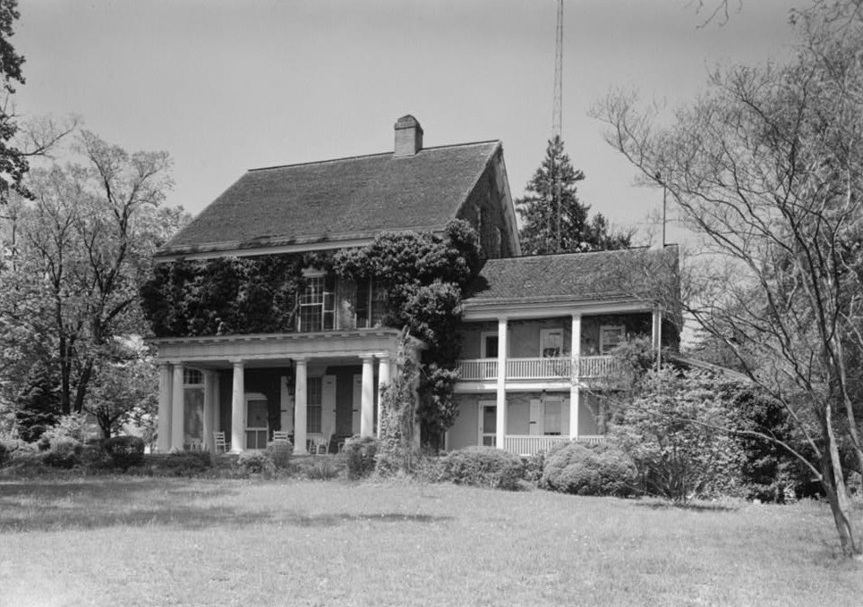
39°00′27″N 75°28′03″W / 39.0075°N 75.4675°WFrederica 63 George Farmhouse October 19, 1982 East of Smyrna off Delaware Route 6
39°18′41″N 75°33′00″W / 39.311389°N 75.55°WSmyrna 64 Golden Mine August 24, 1978 West of Milford on County Road 443
38°54′19″N 75°29′08″W / 38.905278°N 75.485556°WMilford 65 Governor's House 
December 5, 1972 Kings Hwy.
39°09′41″N 75°31′25″W / 39.161389°N 75.523611°WDover 66 Great Geneva March 26, 1973 3 miles south of Dover on County Road 356
39°07′10″N 75°30′32″W / 39.119444°N 75.508889°WDover 67 Green Mansion House June 27, 1983 Main St.
39°13′37″N 75°40′37″W / 39.226944°N 75.676944°WKenton 68 Greenwold 
March 20, 1973 625 S. State St.
39°09′06″N 75°31′19″W / 39.151667°N 75.521944°WDover 69 Griffith's Chapel October 29, 1983 Junction of County Roads 442 and 443
38°53′45″N 75°30′30″W / 38.895833°N 75.508333°WWilliamsville 70 Robert Hill House August 29, 1983 Delaware Route 6
39°16′33″N 75°41′21″W / 39.275833°N 75.689167°WKenton 71 Hoffecker-Lockwood House June 27, 1983 Delaware Route 6
39°13′36″N 75°35′53″W / 39.226667°N 75.598056°WKenton 72 Alfred L. Hudson House June 27, 1983 County Road 90
39°16′10″N 75°37′24″W / 39.269444°N 75.623333°WKenton 73 Hughes Early Man Sites July 24, 1979 Address restricted Felton 74 Hughes-Willis Site November 21, 1978 Address restricted Dover 75 Island Field Site February 1, 1972 Address restricted South Bowers 76 Ivy Dale Farm April 24, 1973 South of Smyrna off Delaware Route 9
39°17′13″N 75°34′47″W / 39.286944°N 75.579722°WSmyrna 77 Enoch Jones House June 19, 1973 Southwest of Clayton off Delaware Route 300
39°16′45″N 75°39′37″W / 39.279167°N 75.660278°WClayton 78 KATHERINE M. LEE (Schooner) April 25, 1983 Fox's Dock at Front and Lombard Sts.
39°14′31″N 75°30′51″W / 39.241944°N 75.514167°WLeipsic 79 Kenton Historic District August 29, 1983 Commerce St.
39°13′36″N 75°39′13″W / 39.226667°N 75.653611°WKenton 80 Kenton Post Office June 27, 1983 Main St.
39°13′38″N 75°39′54″W / 39.227222°N 75.665°WKenton 81 Thomas Lamb Farm August 29, 1983 County Road 130
39°17′35″N 75°41′04″W / 39.293056°N 75.684444°WKenton 82 Thomas Lamb House August 29, 1983 County Roads 129 and 130
39°16′53″N 75°42′26″W / 39.281389°N 75.707222°WKenton 83 Alexander Laws House April 25, 1983 Front and Walnut Sts.
39°14′27″N 75°31′00″W / 39.240833°N 75.516667°WLeipsic 84 Lewis Family Tenant Agricultural Complex August 13, 1986 County Road 227
39°06′15″N 75°36′30″W / 39.104167°N 75.608333°WWyoming 85 Jefferson Lewis House June 27, 1983 Delaware Route 42
39°12′51″N 75°38′02″W / 39.214167°N 75.633889°WKenton 86 John B. Lindale House May 8, 1973 24 Walnut St.
39°04′12″N 75°29′11″W / 39.07°N 75.486389°WMagnolia 87 Little Creek Hundred Rural Historic District November 7, 1984 Delaware Route 9
39°10′47″N 75°28′31″W / 39.179722°N 75.475278°WLittle Creek 88 Little Creek Methodist Church 
May 24, 1982 Main St.
39°09′49″N 75°26′49″W / 39.163611°N 75.446944°WLittle Creek 89 Peter Lofland House April 22, 1982 417 N. Walnut St.
38°55′03″N 75°25′43″W / 38.9175°N 75.428611°WMilford 90 Logan School House K-834 May 22, 1979 County Road 68
39°06′01″N 75°25′49″W / 39.100278°N 75.430278°WKitts Hummock 91 Loockerman Hall June 21, 1971 Delaware State University campus
39°11′06″N 75°32′44″W / 39.185°N 75.545556°WDover 92 Matthew Lowber House April 16, 1971 East of Main St.
39°04′21″N 75°28′50″W / 39.0725°N 75.480556°WMagnolia 93 Lower St. Jones Neck Historic District May 22, 1979 Address restricted Kitts Humock 94 Macomb Farm December 2, 1974 Long Point Rd. off Delaware Route 8
39°10′58″N 75°28′38″W / 39.182778°N 75.477222°WDover 95 MAGGIE S. MYERS (schooner) April 25, 1983 Killen's Dock at Front and Lombard Sts.
39°14′30″N 75°30′53″W / 39.241667°N 75.514722°WLeipsic 96 McClary House April 25, 1983 Main and McClary Sts.
39°14′23″N 75°30′49″W / 39.239722°N 75.513611°WLeipsic 97 James McColley House January 7, 1983 414 NW. Front St.
38°54′46″N 75°26′07″W / 38.912778°N 75.435278°WMilford 98 Delaplane McDaniel House June 27, 1983 County Road 92
39°13′36″N 75°35′53″W / 39.226667°N 75.598056°WKenton 99 Mifflin-Marim Agricultural Complex November 7, 1984 Delaware Route 9
39°12′40″N 75°30′06″W / 39.211111°N 75.501667°WDover 100 Mount Pleasant September 11, 1992 Sunnyside Rd. (County Road 90) in Duck Creek Hundred
39°16′38″N 75°36′27″W / 39.277222°N 75.6075°WSmyrna 101 Milford New Century Club April 22, 1982 6 S. Church Ave.
38°54′44″N 75°25′53″W / 38.912222°N 75.431389°WMilford 102 Mill House January 7, 1983 414 NW. Front St.
38°54′47″N 75°26′05″W / 38.913056°N 75.434722°WMilford 103 Moore House October 19, 1982 511 W. Mt. Vernon St.
39°17′45″N 75°36′52″W / 39.295833°N 75.614444°WSmyrna 104 Mordington 
April 13, 1973 South of Frederica on Canterbury Rd.
38°58′07″N 75°29′39″W / 38.968611°N 75.494167°WFrederica 105 North Milford Historic District January 7, 1983 Roughly bounded by Mispillion River, Silver Lake, N. Walnut and NW. 3rd Sts.
38°54′53″N 75°25′52″W / 38.914722°N 75.431111°WMilford 106 Octagonal Schoolhouse 
March 24, 1971 East of Cowgill
39°11′44″N 75°28′21″W / 39.195556°N 75.4725°WCowgill's Corner 107 Old Fire House January 7, 1983 Church Ave.
38°54′52″N 75°25′50″W / 38.914444°N 75.430556°WMilford 108 Old Statehouse 
February 24, 1971 The Green
39°09′23″N 75°31′23″W / 39.156389°N 75.523056°WDover 109 Old Stone Tavern 
July 2, 1973 Main St.
39°09′51″N 75°26′51″W / 39.164167°N 75.4475°WLittle Creek 110 Palmer Home 
September 13, 1988 115 American Ave.
39°09′50″N 75°31′31″W / 39.163889°N 75.525278°WDover 111 Peterson and Mustard's Hermitage Farm October 26, 1982 East of Smyrna off County Road 325
39°17′32″N 75°34′13″W / 39.292222°N 75.570278°WSmyrna 112 Poinsett House June 27, 1983 Delaware Route 6
39°15′46″N 75°44′34″W / 39.262778°N 75.742778°WKenton 113 Port Mahon Lighthouse 
October 25, 1979 Northeast of Little Creek
39°11′05″N 75°24′04″W / 39.184722°N 75.401111°WLittle Creek 114 Rawley House April 25, 1983 Main St.
39°14′26″N 75°30′51″W / 39.240556°N 75.514167°WLeipsic 115 Raymond Neck Historic District November 8, 1982 North of Leipsic between Leipsic River and County Road 85
39°14′53″N 75°30′32″W / 39.248056°N 75.508889°WLeipsic 116 Reed House April 25, 1983 Lombard St.
39°14′31″N 75°30′47″W / 39.241944°N 75.513056°WLeipsic 117 Jehu Reed House June 4, 1973 Delaware Route 1
39°02′30″N 75°27′27″W / 39.041667°N 75.4575°WLittle Heaven 118 Ruth Mansion House 
April 11, 1973 Main St.
39°14′25″N 75°30′51″W / 39.240278°N 75.514167°WLeipsic 119 Savin-Wilson House September 11, 1992 County Road 326, between County Road 12 and County Road 83, in Duck Creek Hundred
39°17′11″N 75°32′09″W / 39.286389°N 75.535833°WSmyrna 120 Saxton United Methodist Church 
July 23, 1990 Junction of Main and Church Sts.
39°03′30″N 75°24′14″W / 39.058333°N 75.403889°WBowers 121 Short's Landing Hotel Complex October 17, 1983 Northeast of Smyrna
39°20′49″N 75°32′20″W / 39.346944°N 75.538889°WSmyrna 122 Sipple House May 24, 1982 Denny and Front Sts.
39°14′27″N 75°31′04″W / 39.240833°N 75.517778°WLeipsic 123 Smyrna Historic District 
May 23, 1980 Delaware Route 6 and U.S. Route 13
39°17′59″N 75°36′24″W / 39.299722°N 75.606667°WSmyrna 124 Snowland March 20, 1973 Delaware Route 42
39°13′46″N 75°31′39″W / 39.229444°N 75.5275°WLeipsic 125 Somerville December 31, 1974 1 mile east of Kenton on Delaware Route 42
39°13′27″N 75°38′42″W / 39.224167°N 75.645°WKenton 126 St. Joseph's Industrial School December 12, 2002 355 W. Duck Creek Rd.
39°17′37″N 75°38′13″W / 39.293611°N 75.636944°WClayton 127 Star Hill AME Church November 25, 1994 County Road 366 southeast of Camden
39°06′06″N 75°32′10″W / 39.101667°N 75.536111°WCamden 128 William Stevens House August 29, 1983 Delaware Route 6
39°16′33″N 75°40′30″W / 39.275833°N 75.675°WKenton 129 Elizabeth Stubbs House May 24, 1982 Main St.
39°09′48″N 75°26′51″W / 39.163333°N 75.4475°WLittle Creek 130 Thomas Sutton House April 11, 1973 County Road 79, with Woodland Beach Wildlife Area
39°19′31″N 75°30′22″W / 39.325278°N 75.506111°WWoodland Beach 131 Tharp House March 20, 1973 East of Farmington on U.S. Route 13
38°52′17″N 75°34′35″W / 38.871389°N 75.576389°WFarmington 132 Thomas' Methodist Episcopal Chapel January 26, 1994 County Road 206 west of Chapeltown, West Dover Hundred
39°05′55″N 75°42′15″W / 39.098611°N 75.704167°WChapeltown 133 Parson Thorne Mansion 
June 21, 1971 501 NW. Front St.
38°54′49″N 75°26′07″W / 38.913611°N 75.435278°WMilford 134 Todd's Chapel September 14, 1998 Junction of Todd's Chapel Rd., and Hickman Rd.
38°50′07″N 75°40′25″W / 38.835278°N 75.673611°WGreenwood 135 Town Point December 5, 1972 Kitts Hummock Rd.
39°04′53″N 75°25′44″W / 39.081389°N 75.428889°WDover 136 Gov. George Truitt House December 12, 1978 Southwest of Magnolia on County Road 388
39°01′10″N 75°32′18″W / 39.019444°N 75.538333°WMagnolia 137 Tyn Head Court March 1, 1973 East of Dover on S. Little Creek Rd.
39°09′15″N 75°28′36″W / 39.154167°N 75.476667°WDover 138 Victorian Dover Historic District 
July 16, 1979 Roughly bounded by Silver Lake, St. Jones River, North and Queen Sts.
39°09′51″N 75°31′35″W / 39.164167°N 75.526389°WDover 139 Vogl House November 7, 1976 West of Masten
38°57′52″N 75°37′44″W / 38.964444°N 75.628889°WMasten's Corner 140 John M. Voshell House October 6, 1983 East of Smyrna
39°18′05″N 75°31′07″W / 39.301389°N 75.518611°WSmyrna 141 Walnut Farm November 10, 1982 Roosa Rd.
38°55′39″N 75°26′09″W / 38.9275°N 75.435833°WMilford 142 Gov. William T. Watson Mansion April 22, 1982 600 N. Walnut St.
38°55′12″N 75°25′47″W / 38.92°N 75.429722°WMilford 143 Wheel of Fortune 
April 11, 1973 South of Leipsic off Delaware Route 9
39°12′53″N 75°30′46″W / 39.214722°N 75.512778°WLeipsic 144 White-Warren Tenant House September 21, 2001 Northeastern side of County Road 261
39°00′56″N 75°40′15″W / 39.015556°N 75.670833°WSandtown 145 J. H. Wilkerson & Son Brickworks 
July 12, 1978 Off County Road 409
38°55′08″N 75°24′50″W / 38.918889°N 75.413889°WMilford 146 James Williams House June 27, 1983 Delaware Route 42
39°13′09″N 75°38′49″W / 39.219167°N 75.646944°WKenton 147 Woodlawn October 19, 1982 Southeast of Smyrna on U.S. Route 13
39°17′23″N 75°35′44″W / 39.289722°N 75.595556°WSmyrna 148 Jonathan Woodley House May 24, 1982 Main St.
39°09′46″N 75°26′48″W / 39.162778°N 75.446667°WLittle Creek 149 Woodside Methodist Episcopal Church February 16, 1996 Main St., North Murderkill Hundred
39°04′19″N 75°34′03″W / 39.071944°N 75.5675°WWoodside 150 Wright-Carry House June 27, 1983 Commerce St.
39°13′35″N 75°39′56″W / 39.226389°N 75.665556°WKenton 151 Wyoming Historic District February 18, 1987 Roughly bounded by Front St., Rodney Ave., Southern Blvd., and Mechanic St.
39°07′11″N 75°33′29″W / 39.119722°N 75.558056°WWyoming 152 Wyoming Railroad Station December 4, 1980 E. Railroad Ave.
39°07′07″N 75°33′31″W / 39.118611°N 75.558611°WWyoming 153 Zion African Methodist Episcopal Church November 25, 1994 Center St.
39°07′01″N 75°33′05″W / 39.116944°N 75.551389°WCamden References
- ^ "National Register of Historic Places: Weekly List Actions". National Park Service, United States Department of the Interior. Retrieved on November 10, 2011.
- ^ Numbers represent an ordering by significant words. Various colorings, defined here, differentiate National Historic Landmark sites and National Register of Historic Places Districts from other NRHP buildings, structures, sites or objects.
U.S. National Register of Historic Places Topics Lists by states Alabama • Alaska • Arizona • Arkansas • California • Colorado • Connecticut • Delaware • Florida • Georgia • Hawaii • Idaho • Illinois • Indiana • Iowa • Kansas • Kentucky • Louisiana • Maine • Maryland • Massachusetts • Michigan • Minnesota • Mississippi • Missouri • Montana • Nebraska • Nevada • New Hampshire • New Jersey • New Mexico • New York • North Carolina • North Dakota • Ohio • Oklahoma • Oregon • Pennsylvania • Rhode Island • South Carolina • South Dakota • Tennessee • Texas • Utah • Vermont • Virginia • Washington • West Virginia • Wisconsin • WyomingLists by territories Lists by associated states Other  State of Delaware
Topics - Index
- Architecture
- Communications
- Culture
- Delegations
- Demographics
- Economy
- Education
- Geography
- Government
- History
- Images
- Landmarks
- Law
- Military
- Music
- Nature
- Organizations
- Parks
- Sports
- Symbols
- Transportation
- Visitor Attractions
Cities Towns - Arden
- Ardencroft
- Ardentown
- Bellefonte
- Bethany Beach
- Bethel
- Blades
- Bowers
- Bridgeville
- Camden
- Cheswold
- Clayton
- Dagsboro
- Delmar
- Dewey Beach
- Ellendale
- Elsmere
- Farmington
- Felton
- Fenwick Island
- Frankford
- Frederica
- Georgetown
- Greenwood
- Hartly
- Henlopen Acres
- Houston
- Kenton
- Laurel
- Leipsic
- Little Creek
- Magnolia
- Middletown
- Millsboro
- Millville
- Milton
- Newport
- Ocean
- Odessa
- Selbyville
- Slaughter Beach
- South Bethany
- Townsend
- Viola
- Woodside
- Wyoming
Counties Categories:- Kent County, Delaware
- National Register of Historic Places in Delaware
-


Wikimedia Foundation. 2010.