- Novy Urengoy
-
For other uses of "Urengoy (disambiguation)|Urengoy", see Urengoy (disambiguation).
Novy Urengoy (English)
Новый Уренгой (Russian)- City[citation needed] - 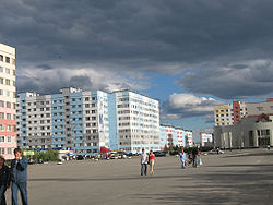
A square in the city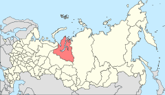
Location of Yamalo-Nenets Autonomous Okrug in Russia
 Novy Urengoy
Coordinates: 66°05′N 76°41′E / 66.083°N 76.683°ECoordinates: 66°05′N 76°41′E / 66.083°N 76.683°E 

Coat of arms Flag Administrative status Country Russia Federal subject Yamalo-Nenets Autonomous Okrug Municipal status Urban okrug Novy Urengoy Urban Okrug[citation needed] Mayor[citation needed] I. I. Kostogriz[citation needed] Statistics Population (2010 Census,
preliminary)104,144 inhabitants[1] - Rank in 2010 154th Population (2002 Census) 94,456 inhabitants[2] - Rank in 2002 176th Time zone YEKST (UTC+06:00)[3] Founded 1975[citation needed] Dialing code(s) +7 3494[citation needed] Official website Novy Urengoy (Russian: Но́вый Уренго́й) is a city in Yamalo-Nenets Autonomous Okrug, Russia. Population: 104,144 (2010 Census preliminary results);[1] 94,456 (2002 Census);[2] 93,235 (1989 Census).[4] It is served by the Novy Urengoy Airport.
It was founded in 1975 after the discovery of the Urengoy gas field, one of the largest in Russia. Town status was granted to it in 1980.
A major business of the district is oil and gas production, with one of the largest gas fields in the world in the area and substantial prospects for further exploration. Gazprom is the main local employer.
The town is situated on the Tyumen–Novy Urengoy railway line. Traveling north from Tyumen, Novy Urengoy is the last station of significance. Noyabrsk is the previous station of significance.
References
- ^ a b Федеральная служба государственной статистики (Federal State Statistics Service) (2011). "Предварительные итоги Всероссийской переписи населения 2010 года (Preliminary results of the 2010 All-Russian Population Census)" (in Russian). Всероссийская перепись населения 2010 года (All-Russia Population Census of 2010). Federal State Statistics Service. http://www.perepis-2010.ru/results_of_the_census/results-inform.php. Retrieved 2011-04-25.
- ^ a b Федеральная служба государственной статистики (Federal State Statistics Service) (2004-05-21). "Численность населения России, субъектов Российской Федерации в составе федеральных округов, районов, городских поселений, сельских населённых пунктов – районных центров и сельских населённых пунктов с населением 3 тысячи и более человек (Population of Russia, its federal districts, federal subjects, districts, urban localities, rural localities—administrative centers, and rural localities with population of over 3,000)" (in Russian). Всероссийская перепись населения 2002 года (All-Russia Population Census of 2002). Federal State Statistics Service. http://www.perepis2002.ru/ct/doc/1_TOM_01_04.xls. Retrieved 2010-03-23.
- ^ Правительство Российской Федерации. Постановление №725 от 31 августа 2011 г. «О составе территорий, образующих каждую часовую зону, и порядке исчисления времени в часовых зонах, а также о признании утратившими силу отдельных Постановлений Правительства Российской Федерации». Вступил в силу по истечении 7 дней после дня официального опубликования. Опубликован: "Российская Газета", №197, 6 сентября 2011 г. (Government of the Russian Federation. Resolution #725 of August 31, 2011 On the Composition of the Territories Included into Each Time Zone and on the Procedures of Timekeeping in the Time Zones, as Well as on Abrogation of Several Resolutions of the Government of the Russian Federation. Effective as of after 7 days following the day of the official publication).
- ^ "Всесоюзная перепись населения 1989 г. Численность наличного населения союзных и автономных республик, автономных областей и округов, краёв, областей, районов, городских поселений и сёл-райцентров. (All Union Population Census of 1989. Present population of union and autonomous republics, autonomous oblasts and okrugs, krais, oblasts, districts, urban settlements, and villages serving as district administrative centers.)" (in Russian). Всесоюзная перепись населения 1989 года (All-Union Population Census of 1989). Demoscope Weekly (website of the Institute of Demographics of the State University—Higher School of Economics. 1989. http://demoscope.ru/weekly/ssp/rus89_reg.php. Retrieved 2010-03-23.
External links
- Official website of Novy Urengoy (Russian)
- Official website of Yamalo-Nenets Autonomous Okrug. Information about Novy Urengoy
Cities and towns in Yamalo-Nenets Autonomous Okrug Administrative center: Salekhard
 Categories:
- Cities and towns in Yamalo-Nenets Autonomous Okrug
- Populated places of Arctic Russia


Wikimedia Foundation. 2010.