- Marford
-
Coordinates: 53°06′00″N 2°57′32″W / 53.10003°N 2.95879°W
Marford 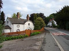
Main road through Marford, showing a typical Gothic Revival house and the Trevor Arms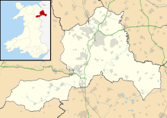
 Marford
Marford shown within WrexhamOS grid reference SJ359563 Community Gresford Principal area Wrexham Ceremonial county Clwyd Country Wales Sovereign state United Kingdom Post town WREXHAM Postcode district LL12 Dialling code 01978, 01244 Police North Wales Fire North Wales Ambulance Welsh EU Parliament Wales UK Parliament Wrexham Welsh Assembly Wrexham List of places: UK • Wales • Wrexham Marford, near Wrexham, is a village in the county borough of Wrexham in Wales. It has been described as "a delightful Gothick estate village"[1] and several of its cottages have been listed by Cadw.
Marford covers some 750 acres (3.0 km2), where the hills of north-east Wales meet the Cheshire Plain. Distant landmarks that can be seen clearly from Marford include Eaton Hall, Chester Town Hall and Cathedral. Beyond that on the Cheshire plains, Peckforton Castle and its hills form the skyline, with the outcrop of rock at Beeston Castle.
Contents
History
Marford was formerly always pronounced and spelt Merford, and continued to be written as such on the township rate books until 1804.[2] The name is English in origin, and may mean either the "ford of the mere", or refer to "mere" in its alternative sense of "boundary".[2] At the time of Domesday Merford was, along with Wrexham, one of the two commotes of the Lordship of Bromfield, or Maelor Gymraeg, and at that time was part of the English county of Chester, although it soon after became part of the Welsh kindgdom of Powys Fadog.[3] It once formed a small enclave of Flintshire completely surrounded by Denbighshire. Formerly in the ancient parish of Gresford, in 1840 the township of Marford and Hoseley became part of the newly formed parish of Rossett.[4]
A detached part of Marford (or Merford) township lay in neighbouring Rossett, next to the bridge over the River Alyn, until 1884.[5] This contained the Marford and Hoseley tenants' mill, with the result that the building often known today as Rossett Mill is still confusingly, though more correctly, referred to as Marford Mill.
The rural area to the south-east of Marford was historically known as Hoseley. It was originally a separate township, and was recorded in the Domesday book as "Odeslei" and later as "Hodeslei", meaning Oda or Hoda's lea (meadow).[6] The name is still attached to several farms, roads and other features. There was an adjacent estate known as Horsley ("horse-pasture"), which is sometimes confused with Hoseley, although the names have different origins.[6]
Architecture
Marford is best known for its quaint looking Gothic revival cottages, built as part of the former Trevalyn Hall estates: the style is also called cottage orné.[7] Although a few are earlier, most were built at the end of the 18th until the beginning of the 19th centuries by George Boscawen, whose wife had inherited the estate.[8] Originally the buildings were roofed in thatch, but were soon re-roofed in Bwlch yr Oernant slate, although some retain the distinctive roof lines of formerly thatched buildings. Many of Marford's houses feature crosses built into the design. A local folk tale states that these were included to protect the inhabitants from a ghost, supposedly the spirit of Margaret Blackbourne of Rofft Hall, who was said to have been murdered in September 1713 by her husband George Blackbourne, the steward of the Trevalyn estate.[9] The original story having become garbled over the years, the ghost of Marford is often now referred to as "Lady Blackbird", and is said to tap at windows in the village.[10]
Today
Although still largely surrounded by farmland, Marford is now partly contiguous with the larger village of Gresford to the south-west, and forms part of the community of Gresford for local administration purposes. Marford and Hoseley is still, however, a separate ward of Wrexham County Borough, having a population of 2,458 at the 2001 census.[11]
There are two public houses in Marford, one at the bottom of the Marford hill - The Trevor Arms (its name referencing the landowning family of Trevalyn Hall, the Trevors) - and the other at the top, The Red Lion. There are no shops in Marford or places of worship, although there were two Nonconformist chapels; a Baptist chapel in Cox Lane and Wesleyan chapel on the old turnpike lane in the Pant. Both are now private houses.
The village also has a disused quarry which has become colonised by many interesting plants, moths and butterflies,[12] including the Dingy Skipper and White-letter Hairstreak: a small colony of the Silver-studded Blue, introduced from Prees Heath in the 1970s, may now have died out.[13] The quarry was originally opened in 1927 to provide materials for the construction of the Mersey Tunnel, quarrying ceased in 1971 when the 39 acres (160,000 m2) were allowed to regenerate naturally. The area was designated a SSSI in 1989 and 26 acres (110,000 m2) were purchased in 1990 by the North Wales Wildlife Trust as a nature reserve.
References
- ^ Beazley & Howell, The companion guide to North Wales, Collins, 1975, p.61
- ^ a b Palmer, A. N. A History of Ancient Tenures of Land in North Wales..., 1910, p.128
- ^ Palmer, p.44
- ^ Gresford, All Saints, GENUKI
- ^ Palmer, p.69
- ^ a b Palmer, p.139, 237
- ^ Cottage orné, Conservation Glossary, University of Dundee
- ^ Marford's Gothic Cottages, Chester Chronicle, 16-02-09
- ^ Holland, R. Supernatural Clwyd: the folk tales of North-East Wales, Gwasg Carreg Gwalch, 1989, pp.195-196. George Blackbourne, also spelt Blackborne, is recorded as having been buried at Gresford on November 4, 1725, leaving two children by his first wife and two by his second wife (see Archaeologia Cambrensis, 1904, 306-308).
- ^ Holland, p.196
- ^ Marford and Hoseley Ward, Wrexham County Borough Council
- ^ Marford Quarry Nature Reserve, North Wales Wildlife Trust
- ^ Action Plan for Wales, Butterfly Conservation, p.153
External links
- Official Cadw site
- North Wales Wildlife Trust site
- photos of Marford and surrounding area on geograph
Wrexham County Borough Principal settlements 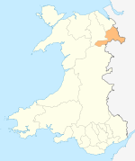
Communities Abenbury • Acton • Bangor-on-Dee • Bronington • Broughton • Brymbo • Caia Park • Cefn • Ceiriog Ucha • Chirk • Coedpoeth • Erbistock • Esclusham • Glyntraian • Gresford • Gwersyllt • Hanmer • Holt • Isycoed • Llangollen Rural • Llansantffraid Glyn Ceiriog • Llay • Maelor South • Marchwiel • Minera • Offa • Overton-on-Dee • Penycae • Rhosddu • Rhosllannerchrugog • Rossett • Ruabon • Sesswick • Willington WorthenburyOther villages and areas Acrefair • Arowry • Bersham • Borras Park • Bradley • Bryn Offa • Brynteg • Burton • Bwlchgwyn • Caego • Cefn Mawr • Cross Lanes • Froncysyllte • Garden Village • Glyn Ceiriog • Gwynfryn • Hightown • Horseman's Green • Johnstown • Llanarmon Dyffryn Ceiriog • Marford • Moss • Penley • Pentre Broughton • Pentre Bychan • Pentre Maelor • Ponciau • Pontfadog • Rhosrobin • Rhostyllen • Rhosymedre • Southsea • Stansty • Summerhill • Sydallt • Tanyfron • Tregeiriog • TrevorCastles Chirk Castle • Holt CastleBuildings and structures Rivers Geographical features Esclusham Mountain • Fenn's Moss • Ruabon MoorsCategories:- Villages in Wrexham county borough


Wikimedia Foundation. 2010.